Northeast Region:
(Information provided by the Northeast
Regional Climate Center)
- Despite some significant temperature swings during the month in
the Northeast, December's average temperature was exactly normal or
28.4°F (-2.0°C). Only three states had temperatures that
averaged below normal: Maine (-1.9°F, 1.1°C); New
Hampshire and New York (-0.1°F, -0.1°C). Departures among
the remaining states ranged from normal in Connecticut to
2.1°F (1.2°C) above normal in Delaware.
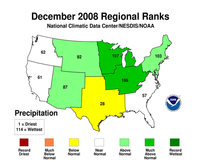
- The Northeast's average precipitation total was 4.90 inches
(12.45 cm), making this month the tenth wettest December since
1895. Among the states in the region, it was the third wettest in
Pennsylvania, the 9th wettest in Connecticut and the 10th wettest
in New Jersey. Precipitation totals ranged from 117% of normal in
Maine to 164% of normal in New Jersey and Pennsylvania. In spite of
the wet conditions in the Northeast, the U.S. Drought Monitor
indicated that portions of northwest Pennsylvania remained
abnormally dry and the southern half of West Virginia continued to
experience moderate drought conditions as of December 30, 2008.
- The Northeast experienced a season's worth of winter weather in
December. The first major event was an ice storm on the 11th and
12th that left over a million homes and businesses without power in
portions of New Jersey, New York, Connecticut, Rhode Island,
Massachusetts, Vermont, New Hampshire and Maine. Conditions were
most severe in New Hampshire and Massachusetts, where downed trees
and power lines closed over 300 state and local roads, shelters
housed over 3000 and states of emergency were declared by President
Bush. While ice was coating northern and interior locations, 3 to 5
inches of rain drenched the coastal plain from Maryland to
Massachusetts as well as eastern Pennsylvania. Highway and river
flooding were reported in the areas of heaviest rainfall.
A week later, a series of storms brought snowy conditions to the
northern half of the region, including areas still recovering from
the ice storm. About 26,000 residents in Massachusetts were still
without power when the first winter storm warning was issued on the
19th. By the time the snow ended on the 22nd, 6 to 24 inches of
snow blanketed the northern half of the Northeast.
Cold temperatures and high winds postponed New Year's Eve
celebrations in New Bedford, MA and Baltimore, MD, but did not keep
the crowds away from Times Square. Wind speeds of 20 to 25 mph and
gusts of 35 to 40 mph yielded a wind chill near zero as the crowd
greeted the new year.
For more information, please go to the Northeast
Regional Climate Center Home Page.
Midwest Region:
(Information provided by the Midwest
Regional Climate Center)
- December was a cold and wet month for most of the Midwest.
Temperatures were below normal across the entire region, ranging
from only slightly below normal in southeastern Ohio to 9°F
(5°C) below normal in northwestern Minnesota. Temperature
departures were generally more than 3°F (1.7°C) below
normal north of a line from Kansas City, MO to Detroit, MI. Subzero
readings were frequent the first half of the month across the
northern Midwest where snow cover was persistent. Temperature
extremes across the Midwest ranged from -35°F (-37°C) at
Babbit and Brimson, MN on December 17 to 75°F (24°C) at
Henderson, KY on December 29.
- Precipitation ranged from near normal in southwestern Missouri
to much above normal in the upper Midwest. Precipitation was
generally 150 to 200 percent of normal north of a line from Sioux
City, IA to Louisville, KY. The largest departures above normal
were found in northwestern Minnesota, southern Wisconsin, northern
Illinois, and much of Michigan. Based on preliminary data, this was
the second wettest December on record for Michigan; the fourth
wettest for Ohio and Wisconsin; the seventh wettest for Indiana and
Minnesota; and the eighth wettest for Illinois. In Kentucky,
December was the first month since July with above normal
precipitation, which helped to alleviate the drought conditions
that have persisted in the state. December snowfall ranged from 200
percent of normal to more than 400 percent of normal north of a
line from Kansas City, MO to Detroit, MI. South of this line
December snowfall was less than 60 percent of normal. In Iowa this
was the fourth snowiest December among 122 years of state snow
records.
- There were frequent freezing rain events across the central
Midwest during the month. The storms produced widespread power
outages and hazardous travel. In Indiana alone, 16 deaths occurred
in traffic accidents due to the ice and many injuries resulted from
falls on the ice covered ground. Long sections of interstate
highways were closed at times due to numerous accidents and slide
offs. High winds slowed utility crews from restoring widespread
power outages after a storm on December 18. An ice storm in
Kentucky on December 23 resulted in four deaths due to traffic
accidents. Strong southerly winds ahead of a strong storm system on
December 27-29 brought much warmer air and heavy rain to the
Midwest, causing rapid snow melt. The rapid snow melt along with
the heavy rain brought flooding to many rivers across southeastern
Iowa, northern Illinois, and northwestern Indiana. The flooding
from the rain and snow melt was exacerbated in some areas by ice
jams on rivers. At the end of the month most of the flooding had
subsided, but moderate flooding was still occurring on the Illinois
River in central Illinois.
For details on the weather and climate events of the Midwest during
December, see the weekly summaries in the
MRCC Midwest Climate Watch page.
Southeast Region:
(Information provided by the Southeast Regional
Climate Center)
- In contrast to recent trends, average temperatures for December
2008 were above normal across the region, with exception to a small
portion of southern FL and northern VA. More than three-quarters of
the region displayed temperatures that were 2.0°F (1.1°C)
or more above normal. Portions of SC and extreme eastern GA
displayed mean temperatures more than 6.0°F (3.3°C) above
normal. Most notably, Augusta, GA recorded a mean temperature of
54.3°F (12°C), which was the 4th warmest December in a
60-yr record. In most of the region, the coldest temperatures were
observed in the first half of the month. There were only 44 record
lows set during the month and more than half of these records
occurred in FL. Most notably, Lake City, FL recorded a minimum
temperature of 25°F (-4°C) on the 13th of the month. The
cold air did not have a significant impact on agricultural
interests in the region. At least 213 record high temperatures were
set across the region. Augusta, GA recorded a high temperature of
82°F (28°C) on the 18th, which tied with dates from
several years for being the warmest daily high for December. Mean
monthly temperatures were average to slightly below average across
Puerto Rico.
- There was much variability in the monthly precipitation totals
across the region. Precipitation totals were below normal across
most of FL southeastern GA, SC and NC as well as small portions of
northern VA, central GA and southern AL. The area of greatest
precipitation deficits included much of FL and southeastern
portions of GA, SC, and NC, which received less than half of the
normal precipitation for the month. In contrast, precipitation
totals were above normal over portions of northwestern and
southeastern AL, northern and southwestern GA, western SC, western
NC and southern VA. Several locations within this region recorded
monthly totals that exceeded 200% of normal. Nearly 12 inches (300
mm) of precipitation fell in Huntsville, AL, making it the 5th
wettest December on record. Much of the precipitation for the month
was associated with low pressure systems tracking across the
Midwest and Great Lakes and pushing cold fronts through the area.
An exceptionally strong low developed along a stalled front and
tracked northeastward from the Gulf Coast across the eastern slopes
of the Appalachians on the 10th and 11th of the month. Many
locations in the western and northern portions of the region
received more than 2 inches of rain over this two day period. Berry
and Moulton AL received over 5 inches (130 mm) of rain on the 10th
and several stations in the western panhandle of Florida reported
two day precipitation totals exceeding 6 inches (150 mm). This
rainfall produced some minor flooding along small rivers and
streams. Most of Puerto Rico recorded precipitation totals that
were below normal for the month. Relatively little snow was
reported across the Southeast, and what fell was largely confined
to the mountains. The greatest monthly snowfall total was a mere
8.4 inches (213 mm), which was recorded in Nora, VA.
- Above normal precipitation during the month contributed to a
slight lessening of the drought persisting across northwestern SC
extreme NE GA and extreme western NC. Drought intensity lowered
from the exceptional to the extreme category in this region. This
marked the first time in six months that no area in the Southeast
experienced exceptional drought conditions. Moderate drought
conditions disappeared across NE AL but continued across
southwestern VA, portions of western NC, and west-central FL. There
were very few reports of severe weather across the region during
the month. Wind damage was reported in a few places across northern
FL in connection with the cyclone on the 10th and 11th. Also, wind
gusts exceeding 60 mph were reported in several mountainous areas
of western NC on the 31st of the month.
For more information, please go to the Southeast Regional
Climate Center Home Page.
High Plains Region:
(Information provided by the High Plains
Regional Climate Center)
- While November was warmer than normal across the region,
December was below normal for most of the region. The monthly
average temperature departures from normal generally ranged from
-2°F to -6°F (-1.1°C to -3.3°C), however
several locations exceeded 8°F (4.4°C) below normal. Many
stations recorded average temperatures that ranked in the top 10
for coldest Decembers on record. Record setting locations include
Grand Forks International Airport, ND, Redfield, SD, Cody Municipal
Airport, WY, and Lincoln, NE. With the 4th coldest December on
record, Grand Forks International Airport had an average
temperature of 5.1°F (-14.9°C). Redfield had an average
temperature of 9.8°F (-12.3°C) which was the 5th coldest
December on record. Cody Municipal Airport recorded its 8th coldest
December on record with an average temperature of 18.5°F
(-7.5°C) and Lincoln recorded its 9th coldest December with an
average temperature of 23.0°F (-5°C).
- Precipitation varied quite a bit across the region this month
as there were widespread areas of both above and below normal
precipitation. Dry locations which received less than 50% of normal
precipitation included much of Wyoming, Colorado, Nebraska, and
Kansas, and pockets of eastern South Dakota and north central North
Dakota. Areas experiencing drought did not get any relief this
month as drought conditions have remained largely unchanged across
the region. For instance, the Rawlins Municipal Airport in Wyoming
recorded no precipitation and tied the record for driest December
(last set in 2001). Areas that received at least 150% of normal
precipitation include North Dakota, South Dakota, the western half
of Colorado, the northwestern part of Wyoming, and small pockets of
Nebraska. Extreme locations in North Dakota and Colorado received
above 400% of normal precipitation. Many locations in North Dakota
broke December snowfall records. Most interestingly, Bismarck not
only recorded the record December snowfall, but also the total
snowfall for any one month. Bismarck recorded 33.3 inches (84.58
cm) of snow in December breaking the previous record of 21.7 inches
(55.12 cm) set in 1916. Bismarck December snowfall also set the
record snowfall for any month by beating the previous record of
31.1 inches (78.99 cm) set in March 1975.
- A blizzard struck North Dakota and South Dakota December 13-14.
Snowfall totals ranged from 1-14 inches (2.54-35.56 cm). Strong
winds gusting over 50 mph (80.5 km/h) accompanied the snow which
reduced visibilities to zero and created wind chills from
-30°F to -50°F (-34.4°C to -45.6°C). I-90 was
closed in South Dakota, I-94 was closed in North Dakota, and I-29
was closed from South Dakota to the Canadian border.
For more information, please go to the High Plains
Regional Climate Center Home Page.
Southern Region:
(Information provided by the Southern
Regional Climate Center)
- During the month of December, average temperatures in the
Southern Region were generally within 0 to 2°F
(°0-1°C) of normal. Temperatures in Arkansas were only
slightly below normal. Similar conditions were observed in eastern
Oklahoma, western Tennessee, and parts of northeast Texas.
Elsewhere, temperatures were only slightly above the monthly norm,
with the exception of southeastern Louisiana and southern
Mississippi; where temperatures averaged between 4-6°F
(2-3°C) above normal.
- In December, precipitation in the Southern Region was well
below normal in the western states of Texas and Oklahoma,
near-normal to slightly below normal in the central states of
Arkansas and Louisiana, and well above normal in Tennessee and
northern Mississippi. The driest area of the Southern Region
included a large portion of north central Texas, where most
stations reported less than 0.1 inches (2.54 mm). In fact, a
majority of stations in Texas climate division 2 (Low Rolling
Plains) did not record any precipitation for the entire month.
Throughout Texas, most stations reported 50% or less of the monthly
average. Similar conditions occurred in western and central
Oklahoma. In Arkansas, only the eastern counties received
near-normal precipitation. Conditions in the remainder of the state
were dry, with most stations reporting between 50-90% of the
monthly normal. In Louisiana, conditions were dry in the south and
northwestern portions of the state. Central parishes did observe
near-normal precipitation. In Mississippi, precipitation was
generally well above normal, particularly in the central and
northern counties. Within those regions, precipitation totals
varied from 130 to over 200% of normal. In Tennessee, similar
conditions were observed with much of the state enjoying a very wet
month for a change, including the eastern counties where drought
has been persistent for many months.
- Drought conditions in the Southern Region have changed slightly
over the past month. Below normal precipitation totals in south
central Texas has led to a slight deterioration of drought
conditions. Specifically, the area of exceptional drought in south
central Texas has expanded slightly from last month. Conversely,
above normal precipitation in Tennessee has led to a significant
improvement in drought conditions. For example, the eastern portion
of the state has seen drought conditions change from extreme
drought to just moderate drought. In addition, central counties in
the state that were observing moderate to severe drought are now
drought-free.
For more information, please go to the Southern
Regional Climate Center Home Page.
Western Region:
(Information provided by the Western
Regional Climate Center)
- Temperatures throughout the west were mostly below normal
except for New Mexico, eastern Arizona and isolated pockets of the
Rockies. Parts of eastern Montana were 8°F (4.5°C) below
normal, the coldest December in 12 years. This followed on the
heels of a very warm November where eastern Montana was
8°F(4.5°C) above normal. Seattle and Spokane, WA, and
Pendleton, OR, recorded their coldest Decembers since 1990. On the
opposite end of the extreme, Barrow, AK, recorded their second
warmest December in 60 years of observations.
- Precipitation was a very mixed bag with no discernable pattern.
Much of the southwest and northern plains were well above normal
with the Pacific northwest being below normal as well as most of
Wyoming and southern New Mexico. Although precipitation was only
60-75% of normal in NW Washington this was the snowiest months in
13 years at lower elevations. Spokane measured 61.5 inches (156 cm)
of snow, the greatest monthly total ever with records dating back
113 years. Through December Spokane had already measured 63 inches
(160 cm) of snow so far this winter, roughly 140% of their annual
average. Crater Lake National Park recorded 13.86 inches (352 mm)
of precipitation and 169.9 inches (432 cm) of snow, with the snow
depth climbing from 0 on the 7th to 74 inches (188 cm) on the 29th.
The 3.38 inches (86 mm) of rain in San Diego was the second
greatest December total in the past 25 years. In Palm Springs 1.62
inches (41 mm) of rain fell on the 17th leading to the wettest
December in 42 years. Winter finally reached the Sierra Nevada
mid-month. Through December 12th, New Orleans LA had measured more
snow than Lake Tahoe (Tahoe City) CA, but that changed quickly. By
the end of the month, the Sierra Nevada snowpack had risen from 3%
of normal on the first to 85% of normal on the 31st. Most of Hawaii
had an extremely wet month with Hilo recording its wettest December
since 1971 (30.38 inches, 772 mm).
- Western snowpack ranged from over 200% percent of normal in
parts of the Southwest on January 1, 2009, to slightly below normal
in the Sierra of California (85%) and the Pacific Northwest (90%)
to near normal in the Intermountain west (90-110%).
For more information, please go to the Western
Regional Climate Center Home Page.
Alaska: (Information provided by Audrey
Rubel at NOAA NWS Alaska Region Headquarters.)
- Barrow experienced a very warm December. Over an 88 year
timeframe, Barrow's December 2008 average maximum temperature of
7.9°F was the warmest; average monthly temperature of
0.5°F was the second warmest; and average minimum temperature
of -7.0°F was the third warmest. Barrow also experienced
several daily record high temperatures: 29°F on the 13th,
beating the old record of 26° F set in 1932; 30°F on the
14th, beating the old record of 23°F set in 1932; 26°F on
the 15th, beating the old record of 24°F set in 1984; and
29°F on the 19th, tying the old record set in 1990. On the
18th, Nome experienced its warmest minimum temperature ever on this
date, 31°F, breaking the record of 30°F set in 1986. On
the 16th and 17th, Cold Bay tied the record high minimum
temperature of 40°F set in 1983 and 1984 respectively. King
Salmon hit a record high temperature of 45°F on the 4th,
breaking the old record of 43°F, set in 2002. Bethel's average
monthly temperature was 5.2°F above normal. In the Southeast,
high and low temperatures were well below normal. Juneau and
Yakutat were 6.4 and 4.1°F, respectively, below normal for the
month.
- On the 6th, Fairbanks airport recorded 2.8 inches of snow,
breaking the old snowfall record of 2.2 inches set for this date in
1991. Also on the 6th, the Fairbanks airport recorded .21 inches of
precipitation, breaking the old record of .11 inches set for that
date in 1918. On the 17th, Nome received .32 inches of
precipitation, much of it rain, breaking the old record of .30
inches for the date set in 1929. Bethel received 171% more
precipitation than normal. Snow totals for Southeast were well
above normal, ranging from 57% above normal in northern locations,
to as much as 170% above normal for the southern panhandle. Total
precipitation was uniformly below normal with deficits ranging from
28% to 55% in Yakutat.
|