Northeast Region:
(Information provided by the Northeast
Regional Climate Center)
- Temperatures in the Northeast averaged a bit cooler than normal
in October. The region's average of 48.1°F (8.9°C) was
1.0 °F (0.6°C) below normal. This was 7.7 degrees F
(4.3°C) cooler than last October, which was the 2nd warmest
October since 1895. Maine was the only state that averaged above
normal, but it was only 0.2 degrees F (0.1°C) above the
30-year mean. The remaining states had temperature departures that
ranged from 0.3 °F (0.2°C) below normal in New Hampshire
to 1.7 degrees F (0.9°C) below normal in Maryland.
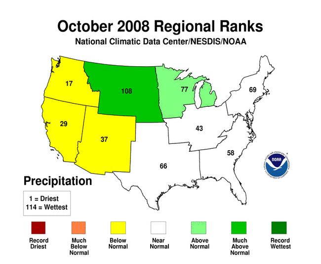
- Precipitation totals from a few weather systems during the last
week of October boosted the state averages in Maine, New Hampshire,
Vermont and New York to near or above normal levels, while the rest
of the region was on the dry side. West Virginia and Maryland were
the driest states, with only 44% and 47% of the normal October
rainfall, respectively. New York, at 128% of normal and Vermont,
with 137% of normal, were the wettest states. Overall, the
Northeast averaged 3.18 inches (81 mm) of precipitation, which was
91% of normal.
- Drought conditions worsened in southern West Virginia,
according to the U. S. Drought Monitor issued at the end of
October. Moderate drought conditions expanded farther north, to the
middle of the state, while the southern tip of the state was in the
severe drought category. The northern part of West Virginia and far
western Pennsylvania were 'abnormally dry', as was much of
Delaware, parts of eastern Maryland and southern New Jersey. Dry
conditions in South Jersey resulted in a fire that burned over 2000
acres within the Wharton State Forest from the 21st to the
25th.
- A week before Election Day, an unusually strong low pressure
system disrupted the World Series, presidential politics, and
everyday routines for Northeast residents. What turned out to be
the last game of the series between the Philadelphia Phillies and
the Tampa Bay Rays was called due to rain on the 27th and didn't
resume until conditions improved on the 29th. Presidential
candidate John McCain cancelled a rally in Quakertown, PA due to
nasty weather conditions. Heavy rainfall and high winds disrupted
travel throughout the New York metropolitan area, but it was the
wind-driven, wet snow that fell on northwestern New Jersey,
northeastern Pennsylvania, northern Vermont, and the Catskills,
Mohawk Valley and Adirondack Mountains of New York that left over
100,000 residents without power. Snow totals ranged from a few
inches to over a foot (305 mm), mainly depending on elevation. Even
sea level locations saw snow from this event - Atlantic City
reported a trace of snow on the 28th - the first time snow was
observed on this date since records began there in 1903. About 50
miles (80K) to the north, 1.5 inches (38 mm) of snow whitened New
Brunswick, NJ, tying their record, originally set in 1962, for the
most snowfall in October.
For more information, please go to the Northeast
Regional Climate Center Home Page.
Midwest Region:
(Information provided by the Midwest
Regional Climate Center)
- Temperatures were near normal across most of the Midwest during
October. It was slightly cooler than normal from Missouri into
northern Illinois and across parts of Michigan, where average daily
temperatures ranged from 1°F to 2°F (0.9°C
to1.1°C) below normal. Areas of Indiana, Kentucky, Wisconsin
and Minnesota ended the month with temperatures near to 1°F
(0.9°C) above normal. Average high temperatures ranged from
1°F (0.9°C) above normal over parts of Indiana to
2°F to 3°F (1.1°C to 1.7°C) below normal across
Missouri. Average low temperatures were 1°F to 2°F
(0.9°C to 1.1°C) above normal across northern Minnesota
and below average over much of the rest of the region.
- Precipitation was near to above average across most of the
western half of the Midwest, while eastern portions of the region
saw only 50% to 75% of normal precipitation. Rainfall was heaviest
this month in extreme western parts of Iowa and Minnesota, where as
much as 300% of normal rainfall was reported. Some areas of the
Midwest also saw their first snowfall of the winter season during
October. Parts of northern and northwestern Minnesota, and northern
Wisconsin received up to an inch of snow, with isolated totals of
more than two inches across upper Michigan.
- The growing season came to an end across the Midwest during the
last week of October as cold air plunged south from Canada. On
October 28 and 29 subfreezing temperatures were recorded throughout
the region, with low temperatures dropping into the upper 20s as
far south as the Ohio River.
Severe weather was very limited across the region, with two reports
of wind damage on October 15 in northern Indiana.
For details on the weather and climate events of the Midwest during
October, see the weekly summaries in the
MRCC Midwest Climate Watch page.
Southeast Region:
(Information provided by the Southeast Regional
Climate Center)
- Average temperatures for October 2008 were slightly below
normal over most of the region. A narrow area from southeastern AL
to extreme SE NC displayed temperatures 2-4°F below normal. A
high pressure persisted north or northeast of the region on many
days allowing relatively cool and dry air to move southward across
the region. On the 27th of the month, a strong cold front passed
rapidly across the area in conjunction with the development of a
strong cyclone northeast of the region. Strong northwesterly winds
occurred in response to the tight pressure gradient associated with
this system and a strong high pressure in the southern Great
Plains. The resultant cold advection and nocturnal radiational
cooling provided numerous daily record low temperatures across
southern portions of the area. Both Tallahassee and Jacksonville,
FL recorded all time record low temperatures of 29 and 33°F
(-2 and 1°C), respectively, for the month of October.
Interestingly, minimum temperatures were relatively warmer much
farther to the north in portions of VA as persistent windy
conditions during the nocturnal hours kept the surface air well
mixed. Temperatures were cold enough at Beech Mountain for the
resort to test its new snowmaking equipment.
- Monthly precipitation totals were below normal across VA, NC,
extreme northern SC, northeast GA, and Puerto Rico with many
locations reporting less than half of the normal precipitation. In
contrast, large portions of GA and SC as well as eastern AL
displayed above normal precipitation with many locations recording
totals exceeding 150% of normal. Much of this rain was associated
with the movement of two cyclonic systems across the region on the
9th to 11th and the 24th to 25th of the month. The second system
produced exceptional totals in coastal GA and SC with Charleston,
SC recording 6.57 inches (167mm) of rain. This rainfall contributed
substantially to the monthly totals of 11.10 inches and 9.29 inches
(282 and 236mm) at Charleston, SC and Savannah, GA, respectively,
which rank as the 2nd and 4th wettest Octobers on record. Florida
displayed much variability in monthly precipitation totals with Key
West reporting over 12 inches (305mm) and Mayport, FL, immediately
east of Jacksonville, reporting only 0.55 inches (14mm). Strong
northwesterly flow produced orographic snowfall across higher
elevations of the southern Appalachians during the late month cold
air outbreak. Mount Mitchell NC and Burkes Garden, VA reported 4
inches and 2 inches (50 and 25mm) of snow, respectively, between
the 27th and 29th of the month.
- There was little change in the drought lingering across
portions of the region during the month. Exceptional drought
continued to plague northwestern South Carolina, while extreme
drought conditions continued to affect western NC and northern GA.
Moderate drought conditions affected areas farther south including
central GA and extreme NE AL as well as northeastern NC. There were
17 preliminary tornado reports across portions of GA and FL between
the 7th and 9th of the month. An unusual high wind event affected
central portions of SC on the 24th of the month. Reported wind
gusts of 80 - 113 km/h (50-70 mph) resulted in widespread damage
across the region, including the cities of Columbia, Aiken,
Newberry, and Lancaster.
For more information, please go to the Southeast Regional
Climate Center Home Page.
High Plains Region:
(Information provided by the High Plains
Regional Climate Center)
- Temperatures were cooler than normal across the region for much
of October 2008. Examples of the cool locations include Manhattan
Municipal Airport, KS and Hutchinson, KS. Manhattan Municipal
Airport had an average temperature of 55.4°F (13.0°C)
which was the 3rd coolest October on record. Hutchinson, KS had an
average monthly temperature of 56.7°F (13.7°C) which was
the 4th coolest October on record. The highest temperature in the
region was 94°F (34.4°C) and occurred on October 5th in
Deerfield, KS. The lowest temperature in the region was -1°F
(-18.3°C) and occurred on October 23rd in Encampment 5NE,
WY.
- With the only exceptions being portions of Wyoming and
Colorado, October 2008 was wet with most of the region receiving
ample precipitation. The precipitation was welcomed as it helped
alleviate drought conditions in a number of locations. According to
the Drought Monitor, drought conditions have improved in South
Dakota, western North Dakota, and across the Colorado-Kansas
border.
- Extremes in monthly precipitation across the region include La
Junta Municipal Airport in Colorado which received 3.38 inches (86
mm) of precipitation or 537% of normal, Lenora, KS which received
7.67 inches (195 mm) of precipitation or 619% of normal, and
Minden, NE which received 11.64 inches (296 mm) of precipitation or
761% of normal. This was the wettest October on record for Minden
whose previous October total precipitation record of 7.34 inches
(186 mm) was set back in 1897. Another wet location was Kearney, NE
which also recorded its all-time wettest October on record with
9.36 inches (238 mm). The total precipitation for the year for
Kearney is currently 35.63 inches (905 mm) and this already ranks
as the 4th wettest year ever recorded, even with two months
remaining in the year.
- The High Plains region is reporting more heavy precipitation
this month with several daily and monthly precipitation records
broken. This excessive precipitation also contributed to minor
flooding in north-central Kansas.
For more information, please go to the High Plains
Regional Climate Center Home Page.
Southern Region:
(Information provided by the Southern
Regional Climate Center)
- In the month of September, average temperatures in the Southern
Region were generally near normal to slightly below normal. Areas
of slightly below normal temperatures included southwestern
Arkansas and southeastern Oklahoma. Temperatures there averaged
approximately 2-5°F (1-3°C) below the monthly normal.
Similar values were also observed in the east-central portion of
Texas.
- With the exception of the Texas and Oklahoma panhandles,
precipitation for the month of October was generally below the
expected monthly values. In the northwestern corner of the Southern
region, precipitation totals varied from 150-400% of normal. In
Oklahoma, there was a sharp precipitation gradient, with monthly
totals decreasing rapidly over the central portions of the state.
In eastern Oklahoma, precipitation totals were as low as 5-25% of
normal, but generally between 25 and 50% of normal. Similar
anomalies were also observed in southern Louisiana, southern
Mississippi, and in particular, south east Texas where serious
drought conditions have persisted from the previous month. Northern
Mississippi and western Tennessee recorded near normal
precipitation values for the month as did the south central
counties of Arkansas.
- Drought conditions in the Southern Region changed little
September. Extreme drought conditions were observed in central
Texas, and in eastern Tennessee. Central Tennessee was in a state
of severe drought during October, as was a small area in south
central Texas. Abnormally dry conditions were observed in southern
Louisiana, where precipitation had been quite scarce since the
tropical cyclone activity associated with Hurricanes Gustav and
Ike. Moderate drought was also present in eastern Oklahoma.
- The month of October was a quiet one in terms of severe weather
in the Southern Region. Over the course of the month, there was
only one reported tornado. It occurred on the 6th of the month in
Montabella, Texas. There were no reports of injuries or
damage.
For more information, please go to the Southern
Regional Climate Center Home Page.
Western Region:
(Information provided by the Western
Regional Climate Center)
Not available at time at this time.
For more information, please go to the Western
Regional Climate Center Home Page.
|