Northeast Region:
(Information provided by the Northeast
Regional Climate Center)
- Temperatures in the Northeast averaged 1.1°F (0.6°C)
below normal in November. West Virginias North Central,
Northwestern and Southwestern climate divisions were the only parts
of the region reporting above normal temperatures, leaving that
state with an average that was exactly normal. The remaining states
temperature averages ranged from 0.8°F (0.4°C) below
normal in Pennsylvania to 2.6°F (1.4°C) below normal in
Rhode Island. Preliminary data indicate that the coldest areas this
month were in New York's Northern Plateau, northeastern Vermont and
south central Maine.
- Precipitation totals varied from north to south. Parts of Maine
received over 7 inches (18 cm) in November, while southern New
Jersey, Delaware, and coastal Maryland totaled less than 2 inches
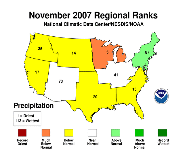
(5 cm). Overall, the Northeast averaged 112% of normal
precipitation, with Delaware the driest, at 43% of normal, and
Maine the wettest, with 181% of the normal November precipitation.
Moderate drought conditions continued in eastern Connecticut, Rhode
Island, central Maryland and southern Delaware; severe drought
conditions persisted in southwestern West Virginia and Maryland's
Eastern Shore.
- During the first week of November, the remnants of Hurricane
Noel made its way from the Bahamas to New England's coastal waters.
Strong winds caused damage from eastern Long Island to Maine, but
Cape Cod, Martha's Vineyard and Nantucket bore the brunt of this
storm. Sustained winds up to 59 mph (95 km/h) and peak gusts as
high as 89 mph (143 km/h) downed trees and power lines, while high
waves and tides eroded beaches. No injuries were reported, but at
least two homes in Chatham, MA were lost to beach erosion.
For more information, please go to the Northeast
Regional Climate Center Home Page.
Midwest Region:
(Information provided by the Midwest
Regional Climate Center)
- The western portions of the region were relatively warmer than
the eastern half of the Midwest during November. Average daily
temperatures ranged from 2.5°F (1.4°C) above normal in
western Minnesota to 1.5°F (0.8°C) below normal in
southern Kentucky and eastern Michigan. Across much of the central
Midwest, temperatures were close to normal. As might be expected
during the fall season, there were several large temperature swings
during the month. The first widespread hard freeze for most of the
region came during the first week of the month, followed by a brief
warm-up and then more cold weather. There was a larger west-to-east
temperature difference during the first half of the month, with
average daily temperatures running about 6°F (3.3°C)
above normal in northwestern Minnesota to 2°F (1.1°C)
below normal in the Ohio Valley. During the last two weeks of
November, the temperature departure gradient was much less as
temperatures were near to a little below normal over most of the
region. The exception was in the Michigan Upper Peninsula (UP),
where a developing snow cover helped keep the temperatures 5°F
(2.8°C) below normal. The first subzero temperatures of the
season occurred the morning of November 27 across snow-covered
northern Minnesota with readings as low as -13°F
(-25°C).
- Dry weather persisted in most of the region west of the
Mississippi River, where November precipitation was less than 25%
of normal, and as low as 5-10% of normal in northwestern Iowa and
southwestern Minnesota. Parts of the Ohio Valley and a band from
east-central Illinois through the northern half of Ohio received
normal to above normal precipitation. Heavy rainfall in Kentucky
during the second and fourth weeks of the month significantly
reduced the drought impacts in the southeastern portion of the
state, and at the end of the month Extreme Drought existed in all
or parts of only nine counties in Kentucky. November snowfall was
generally below normal, except in the lake effect areas in
Minnesota and the Michigan UP.
- Two storms during the last ten days of the month produced
significant snow across the Midwest. The first hit the Wednesday
before Thanksgiving, dropping snow on an area from Iowa through
Michigan and complicating holiday-related travel. On November 27th,
an intense low dropped into the northern United States and produced
heavy snow in the lake effect areas of Minnesota, Wisconsin and
Michigan. The snow was accompanied by winds gusting to 74 mph (119
km/h) in the Michigan UP, downing trees and power lines across the
affected areas. Persistent northwesterly flow across the upper
Midwest kept the lake-effect snow machine running through the end
of the month. By the end of November, up to 18 inches (46 cm) of
snow were on the ground from the arrowhead of Minnesota across the
Michigan UP.
For details on the weather and climate events of the Midwest during
November, see the weekly summaries in the
MRCC Midwest Climate Watch page.
Southeast Region:
(Information provided by the Southeast Regional
Climate Center)
- Drought continued to be the top climate story for almost all of
the southeast USA in November. The end of November is also the end
of the North Atlantic hurricane season. Earlier hopes that
hurricanes would bring relief, partly encouraged in September by
Hurricane Humberto in Alabama and Georgia and tropical storm
Gabrielle in eastern North Carolina, were unfulfilled. Indeed, the
dominance of the Bermuda high pressure system in November, which
helped to steer rain-bearing storms away from the region, seemed to
be even more marked. For numerous stations around the southeast,
November 2007 was the driest November for many years. For several
stations in Virginia and the Carolinas it was the driest on record.
Most notable was the new record for downtown Charleston, South
Carolina, where no rain fell. The old November record was 0.21
inches (0.5 cm), set in 1996, and the only other month which has
ever recorded zero precipitation was October 2000. Farther south,
the lack of rain was less spectacular; it was merely the driest
November for the past few decades. If the current circulation
pattern persists, however, some spots might be on the way to new
annual record dryness. For example, the total rainfall so far this
year, January through November, in Huntsville, Alabama is the
lowest since 1914.
- For much of the month, temperatures in the Southeast followed a
fairly typical November pattern. There were cold spells and warm
periods, balancing out such that the month ended with average
temperatures generally near normal for the month. This was in
contrast to several of the previous months, when many places had
temperatures well above average. These more seasonal temperatures
meant that the rate of evaporation slowed, decreasing the amount of
water naturally removed from the soil. But with no major rainfall,
the drought continued. Early in the month it was still
concentrated, as in earlier months, in the southern Appalachian
Mountains. An expansion southward and eastward took place, followed
by a slight retreat in a few areas by the end of November. The
slight amelioration in the middle of the month in south-central
Florida however, was reversed, and severe drought returned to that
area.
For more information, please go to the Southeast Regional
Climate Center Home Page.
High Plains Region:
(Information provided by the High Plains
Regional Climate Center)
- The temperature remained above normal for much of November,
with most of the region showing between 2-4°F (1.1-2.2°C)
above the 1971-2000 November mean temperature normal. An extreme
temperature swing (although not uncommon during November for the
High Plains Region) occurred in late November during the week of
November 20th, signaling the beginning of winter conditions for
much of the eastern High Plains. Prior to this systems passing,
several daily record-high maximum and minimum temperatures were
broken during the week of November 13th-20th, as locations in
Kansas and Nebraska recorded high temperatures rising into the
upper 70s and low 80s (°F; ~25-28°C). Monthly mean
temperatures would have been higher had this cold snap not
occurred, as it brought lows in the single digits (°F; -12 to
-17°C) to southern parts of the region, and temperatures below
0°F (-18°C) to parts of North Dakota, Wyoming, Colorado
and South Dakota.
- In stark contrast to the record precipitation amounts that
accrued in many eastern locations during the first half of October,
November was extremely dry. The northwest flow pattern that became
dominant during the latter part of October prevailed into November,
and led to dry weather conditions across much of the High Plains
region, particularly for parts of North Dakota, South Dakota,
Nebraska and Kansas. Most stations across this region reported less
than 0.25 inches (0.6 cm) of precipitation, and some locations
reported no measureable precipitation during the month of November.
This may be extreme, but it is not entirely unusual for the High
Plains region, as many locations east of the Rockies have
experienced no measureable precipitation once to several times in
their history for the month of November.
- Previous abnormally dry to moderate drought conditions extended
further into parts of Southwest Nebraska and Western Kansas in
November, reflecting the dryness that occurred over much of the
High Plains region. Winter wheat struggled in parts of Kansas and
Colorado due to very short to short soil moisture conditions. Grass
fires were present in Southern Kansas, where the Aetna fire burned
5,000 acres (20 km²) of vegetation during the week of November
23. The category of Severe Drought was introduced into parts of
Western South Dakota during November as dry conditions prevailed
throughout much of the High Plains.
For more information, please go to the High Plains
Regional Climate Center Home Page.
Southern Region:
(Information provided by the Southern
Regional Climate Center)
- Average monthly temperatures during the month of November in
the Southern Region were generally as expected, with most stations
deviating only 2-4°F (1.1-2.2°C) from the monthly normal.
In northeastern Texas and southeastern Oklahoma, however,
temperatures did average approximately 4-8°F (2.2-4.4°C)
higher than normal. In the Southern region, the highest daily
maximum temperatures ranged from the mid 70s to ~83°F
(~21-28°C), with the exception of central and southern Texas,
where values ranged from ~80-93°F (~27-34°C). Conversely,
the lowest daily minimum temperatures of 9°F (-12.8°C) in
the region were observed in northern Oklahoma. In general, the
lowest daily minimum temperatures ranged from the mid teens
(°F; ~-9°C) in the north of the Southern Region to the
low 40s (°F; ~5°C) in the south of the Southern
Region.
- For the most part, precipitation in the Southern Region was
slightly below normal, with most of the region receiving only
approximately 25-75% of normal precipitation. Conditions were much
drier in most of Oklahoma and northwestern Arkansas, where monthly
totals for most stations remained below the one inch (2.5 cm) mark.
In Oklahoma, the stations at Cordell, Colony, Retrop, Hennessey and
Altus all recorded zero precipitation for the entire month. In
contrast, some areas of the Southern Region, such as southeastern
and western Texas and southeastern and south-central Louisiana,
received above normal precipitation in November. In western Texas,
monthly precipitation totals varied from less than one inch (2.5
cm) at most stations to a total of six inches (15 cm) at Fort
Davis. The latter represents over a five inch (13 cm) deviation
above the monthly normal; it was received over a two day period
from a cold front that began to push through the region on November
24. Further east, persistent drought conditions in eastern
Tennessee continued throughout the month of November. As of
November 27, 46% of the state remains in severe or exceptional
drought. This is an improvement of approximately 4% from conditions
at the start of the month. Small pockets of moderate drought were
also present in the panhandle of Oklahoma, north-central Texas, and
east-central Mississippi at the end of November.
- November 2007 brought several incidents of severe weather to
the Southern Region. Damaging wind was reported on November 6 in
Nashville and Brighton, TN. In Brighton, strong winds knocked down
several trees and power lines. November 13th to the 15th brought
similar wind damage throughout the state. On these days, hail and
damaging winds also affected parts of Arkansas and Mississippi. In
downtown Little Rock, AR, wind gusts of up to 60 mph (97 km/h) were
reported, while in Cleveland, MS, golf ball-sized hail was
reported. On November 22, penny-sized hail was reported in
Tylertown, MS. That same day, damaging winds downed trees and large
limbs in parts of central Louisiana and southern Arkansas.
For more information, please go to the Southern
Regional Climate Center Home Page.
Western Region:
(Information provided by the Western
Regional Climate Center)
- Except for the Pacific Northwest and portions of coastal
California, temperatures for November 2007 were generally above
normal, especially for Alaska, the Southwest and portions of the
intermountain west. Both Tucson and Phoenix recorded their warmest
Novembers on record. Barrow, AK, recorded their 3rd warmest
November. High pressure during the first week produced some
impressive 60 degree (Fahrenheit; 33 degree Celsius) diurnal
temperature ranges in central Nevada with a max and min temperature
of 79°F (26.1°C) and 17°F (-8.3°C) at one
automated station on the 5th.
- Precipitation was generally below normal except for parts of
western Montana, eastern Oregon and portions of Southern California
and Arizona. The southwest was dry until the final day of the
month. Palm Springs had no rain through the first 29 days but ended
up 468% of normal for the month with 1.28 inches (3.3 cm) falling
on the 30th. Most monthly totals in Arizona all occurred on the
final day of the month. Thanks to a Kona low on the 4th, parts of
Oahu received over 10 inches (25.4 cm) of rain. Honolulu measured
3.81 inches (9.7 cm) on the 4th, which was 0.39 inches (1 cm) more
than the total they had received for January—October 2007
(3.42 inches/8.7 cm).
- Dense fog in the San Joaquin Valley south of Fresno on November
3rd caused a series of accidents involving 86 vehicles on Highway
99 during the early morning hours, killing two people. On November
12th, a strong storm system in the Pacific Northwest produced winds
of over 90 mph (145 km/h) along the coast of Washington. Downed
trees and power lines were reported in many locations of Washington
and Oregon. In Idaho, strong winds blew three semi trucks over on
highway 95 near Grangeville, causing two injuries. This storm
produced winds of over 100 mph (160 km/h) in parts of Montana, with
one automated station recording a gust of 106 mph (171 km/h) during
the early morning hours of the 13th.
For more information, please go to the Western
Regional Climate Center Home Page.
Alaska: (Information provided by Audrey
Rubel at NOAA NWS Alaska Region Headquarters.)
- In the southeast part of Alaska, temperatures were generally
close to normal for the month. In other parts of the state, it was
the fifth warmest November on record in Anchorage. The average
temperature of 30.8°F (-0.67°C) was 9.6°F
(5.3°C) above normal. This was in stark contrast to November
2006, which saw an average temperature 9.2°F (5.1°C)
below normal. Up north, Barrow had the third warmest November of
record, with a mean temperature of 13.9°F (-10°C). No sea
ice was visible at the end of November from Barrow. Some ice
visible earlier in the month was blown away by high east winds
before Thanksgiving. According to the NWS office in Barrow and the
residents they have spoken with, this is a first.
- After a wet October, November turned drier for most of
southeast Alaska with stations reporting at or below average
precipitation and below average snowfall. Juneau had 4.5 inches
(11.4 cm) of snow in November, compared to the record breaking 66
inches (168 cm) in November 2006. Elsewhere, Yakutat had the 3rd
lowest precipitation for the month of November since 1971, with
only 13.95 inches (35.4 cm), 1.22 inches (3.1 cm) below normal.
Fairbanks tied for the sixth driest November, with only 0.11 inches
(0.28 cm) of precipitation. Four of the six driest Novembers of
record have occurred since 2001. In contrast, Anchorage had 14.8
inches (37.6 cm) of snowfall, which is 4.3 inches (10.9 cm) above
normal.
- Several high wind events affected southeast Alaska on the
1st-2nd, 10th, 16th, 24th, and 26th. Sustained winds exceeded 40
mph (64 km/h) at many coastal observing stations during the month.
The long wind fetch over the North Pacific the second half of
November allowed seas to build above 20 feet (6.1 m) at the NOAA
data buoy sites. The Cape Suckling buoy reported the highest seas:
38 feet (8.5 m) on November 25.
For more information, please go to the Alaska
Center for Climate Assessment and Policy or the
Alaska Climate Research Center page.
|