Maps and Graphics:
PLEASE NOTE: All temperature and precipitation
ranks and values are based on
preliminary data. The ranks will change when the final data
are processed, but will not be replaced on these pages.
Graphics based on final data are available on the National Temperature and Precipitation Maps
page.
For graphics covering periods other than those mentioned above or
for tables of national, regional, and statewide data from
1895-present, for January, last 3 months or other periods, please
go to the Climate At A Glance
page.
National Overview:
January
For information on local temperature and precipitation records
during the month of January, please visit NCDC's Extremes page.
- Across the United States, extreme drought conditions were
observed in areas of Wyoming and Nebraska, as well as northern
Minnesota and parts of Texas. Exceptional drought was limited to
areas of south Texas. For more information on drought during
January, please visit the U.S. Drought
page.
- El Niño-Southern Oscillation (ENSO) conditions are
indicative of a weak warm episode (El Niño) in the tropical
Pacific basin. Sea Surface Temperatures (SSTs) in the Equatorial
Pacific decreased to between 0.5°C and 1.0°C above
average in most of the Niño regions. Current forecasts
indicate the likely development of ENSO-neutral conditions during
March - May 2007. For additional information on ENSO conditions,
please visit the NCDC ENSO
Monitoring page and the latest
NOAA ENSO Advisory.
For additional details, see the Monthly and
Seasonal Highlights section below and visit the January Climate Summary page. For details
and graphics on weather events across the U.S. and the
globe please visit NCDC's Global Hazards
page.
|
Monthly and Seasonal Highlights:
National:
| For additional national, regional, and
statewide data and graphics from 1895-present, for January, the
last 3 months or other periods, please visit the Climate At A Glance page. |
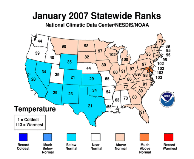
- January 2007 was the
49th warmest January in the 1895-2007 record. The preliminary
nationally averaged temperature was 31.80°F (-0.11°C),
which was 0.94°F (0.52°C) above the 1901-2000 (20th
century) mean.
- January had near-average
precipitation nationally, ranking as the 47th driest January in the
1895-2007 record. An average of 2.07 inches (53 mm) fell over the
contiguous U.S. in January, 0.15 inches (4 mm) below the 20th
century mean for the month.
- The 3-month period (November -
January) was the 7th warmest in the 1895-to-present record,
2.38°F (1.32°C) above the 20th century mean. The
preliminary nationally averaged November - January temperature was
37.97°F (3.32°C). A total of 6.98 inches (177 mm) of
precipitation fell during this 3-month period, which corresponds to
a ranking of 33rd wettest.
- The 6-month (August-January)
national average temperature was the 13th warmest such period on
record. The nationally-averaged temperature was 51.10°F
(10.61°C), which was 1.14°F (0.63°C) above the 20th
century mean. At 15.50 inches (394 mm), August-January
precipitation was above average and ranked as the 13th wettest such
period in the 1895-2007 record.
- February 2006 - January 2007
was the 6th warmest such period in the 1895-2007 record. The
preliminary nationally-averaged annual temperature was 54.41°F
(12.45°C), which was 1.62°F (0.90°C) above the mean.
Precipitation was near the mean for the February 2006 - January
2007 period, ranking it as the 48th driest February-January in the
112-year record. The nationally-averaged annual precipitation
accumulation was 29.02 inches (737 mm), or 0.12 inches (3 mm) below
the 20th century mean.
Regional and Statewide:
- January precipitation
across Texas
was 6th wettest on record. California
was 3rd driest and Utah
was the 10th driest on record. The West
region was 3rd driest on record.
- November - January
temperatures across Connecticut,
New
Hampshire , and New
Jersey ranked 2nd warmest on record. West
Virginia was 6th driest, and Washington
was the 6th wettest for the period.
- In the Northeast, East North Central, and Central regions, November - January temperatures
were much above average.
- Temperatures over the past 6-months (August-January) were
much-above-average in the Northeast and the East North Central
regions having their 4th and 10th warmest such periods on record,
respectively. Precipitation across the Northeast region was the 9th
wettest August-January period on record. The West region ranked 3rd
driest during this period.
- August - January temperatures
were much above average for fifteen states. New Jersey was 2nd
warmest for the period. Colorado and New Mexico had below normal
temperatures for the 6-month period. Indiana ranked 2nd wettest for
August - January. California experienced its 5th driest such period
on record.
- February 2006 - January 2007
was either warmer or much-warmer-than-average for all of the
contiguous U.S. New Jersey was record warmest for the 12-month
period. New Hampshire and Indiana ranked 2nd wettest for the
period.
|
See NCDC's Monthly
Extremes web-page for weather and climate records for the month
of January.
PLEASE NOTE: All of the temperature and precipitation
ranks and values are based on
preliminary data. The ranks will change when the final data
are processed, but will not be replaced on these pages.
Graphics based on final data are available on the National Temperature and Precipitation Maps
page.