Northeast Region:
(Information provided by the Northeast
Regional Climate Center)
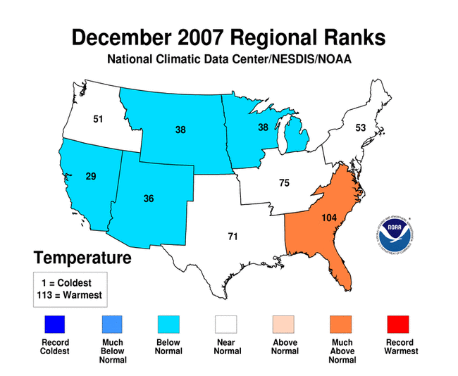
- Temperatures for the month of December averaged above normal in
the southern half of the region and below normal in New England and
New York State. This resulted in a regional average that was
exactly normal. Temperature departures ranged from 2.3°F
(1.2°C) below normal in Maine to 3.2°F (1.8°C) above
normal in West Virginia.
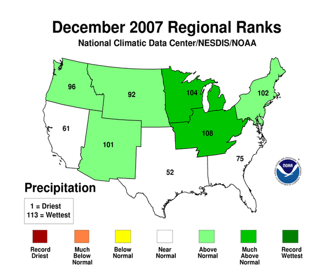
- December was wet in the Northeast. Precipitation totals ranged
from 120% of normal in Connecticut to 163% of normal in West
Virginia where it was the 7th wettest December in 113 years.
December 2007 was also the 6th wettest in Pennsylvania, the 10th
wettest in New York and the 11th wettest in the Northeast. Dry
conditions eased; according to the US Drought Monitor, only the
extreme southern tip of West Virginia and Maryland's Eastern Shore
were still experiencing severe drought. To the north, abnormally
dry conditions were limited to Rhode Island and eastern
Connecticut. According to the December 29, 2007 long-term Palmer
Drought Severity Index, most of the northern half of the region
ranged from unusually moist to extremely moist.
- Cool temperatures, above normal precipitation and an active
weather pattern brought above normal snowfall to parts of the
Northeast in December. Concord, NH, with 44.5 inches (113 cm) of
snow this month, broke the long-standing December record of 43.0
inches (109 cm), set in 1876. Boston, MA needed only 0.3 additional
inches (0.8 cm) of snow to break the record last set in 1970. Their
December total of 27.7 inches (70 cm) made this month the 2nd
snowiest since 1891.
For more information, please go to the Northeast
Regional Climate Center Home Page.
Midwest Region:
(Information provided by the Midwestern
Regional Climate Center)
- December was a cold and snowy month across the northwestern
half of the region, generally north of a Springfield, MO to St.
Louis to Chicago to Detroit line. Temperatures in the northwestern
half of the Midwest ranged from 4°F (2°C) below normal in
western Iowa to near normal in eastern Michigan. In the
southeastern half of the Midwest, temperatures ranged from 1°F
(0.5°C) above normal in southeastern Missouri to 4°F
(2°C) in southeastern Kentucky.
- December was a wet month across all but a few isolated areas of
the Midwest. Precipitation was heaviest in Minnesota, Iowa, and
Wisconsin, as well as along the Ohio River. The only areas with
slightly below normal precipitation were portions of southern lower
Michigan and extreme southeastern Kentucky. At the end of the month
the U.S Drought Monitor continued to depict extreme drought in far
southeastern Kentucky, and small areas of moderate drought in
Minnesota, Wisconsin, Michigan, Missouri, and Illinois. At various
times during the month, rivers in Illinois, Indiana, Ohio, and
Kentucky approached or exceeded flood stage as heavy rain and/or
runoff from melting snow caused rivers and streams to rise.
- The entire Midwest received some measurable snow during
December and snowfall was above normal across the entire region
except for the extreme south. On December 16, snow covered the
Midwest to south of the Ohio River in the wake of a series of
storms that moved through the nation's midsection.
For details on the weather and climate events of the Midwest during
December, see the weekly summaries in the
MRCC Midwest Climate Watch page.
Southeast Region:
(Information provided by the Southeast Regional
Climate Center)
- Persistent drought continued to dominate the climate across
much of the Southeast region, creating an ever-increasing number of
water supply problems. At the beginning of December, approximately
36% of the region suffered from exceptional drought. As the result
of two significant rainfall events during the second half of the
month, the drought coverage was down to 22% by the end of the year.
Some relief came across portions of the Florida panhandle, the
Atlantic Coast and the extreme northwestern portions of
Virginia.
- Heavy rain from these events produced between 4 and 7 inches
(102 and 178 mm) across most of the region, but was particularly
intense across the coastal areas of South Carolina and Georgia. In
Savannah, Georgia, 7.30 inches (185 mm) fell in a 24 hour period
spanning December 20-21 and contributed to a monthly total of 9.44
inches (240 mm), their wettest December on record. The annual
precipitation record in Savannah was being threatened by the lack
of rainfall during 2007 until the December rain events.
- With temperatures running some 4-8°F (2-4°C) higher
than normal throughout December, and with low relative humidity in
many areas, the threat of forest fires was added to the drought
concerns.
For more information, please go to the Southeast Regional
Climate Center Home Page.
High Plains Region:
(Information provided by the High Plains
Regional Climate Center)
- Precipitation was above normal for much of the southern High
Plains region as parts of Nebraska, Colorado and Kansas experienced
an active winter storm pattern for much of December. Liquid
precipitation totals were 200% of normal or higher for much of the
southern High Plains region, while the western Dakotas remained
dry. On December 10, a large storm system moved through central and
eastern Kansas bringing record precipitation amounts and
sub-freezing temperatures, resulting in a deadly mix of ice and
heavy snow. For the month, Grand Junction, CO reported 2.05 inches
(52 mm) of precipitation, which broke the previous December record
of 1.89 inches (48 mm) set in 1951.
- Those regions receiving above normal precipitation amounts also
experienced below normal mean temperature for the month of
December, with departures of 4-8°F (2-4°C) below normal
for parts of Nebraska and northern Kansas. The western Dakotas
experienced above normal temperatures and below normal
precipitation, continuing their warm and dry trend through
2007.
For more information, please go to the High Plains
Regional Climate Center Home Page.
Southern Region:
(Information provided by the Southern
Regional Climate Center)
- In the Southern Region, average temperatures were approximately
2 to 4°F (1 to 2°C) below normal throughout most of
Oklahoma and north central Texas. Overnight lows in these parts
reached the single digits on several occasions. In fact, on the
29th of the month, Beaver, OK reported a temperature of 1°F
(-17°C). In west-central Texas and northern Arkansas,
temperatures deviated only slightly from the monthly mean.
Elsewhere, average temperatures were generally above normal by
approximately 2 to 6°F (1 to 3°C), with the exception of
central Tennessee and west-central Mississippi, where values ranged
from 6 to 8°F (3 to 4°C) above normal.
- During the month of December, precipitation totals were
generally above normal in the north and below normal in the south.
In southwestern Texas, conditions were quite dry with most stations
reporting less than one inch of precipitation for the entire month,
which is 50 percent or less of normal precipitation for most areas.
Similar percentages were also observed in south central Tennessee
and northeastern Mississippi. In Louisiana, the only area of above
normal precipitation occurred predominately in the southeast
portion of the state. In northern Arkansas, precipitation was above
normal, with the highest values across the north central and
northeast portions of the state.
- In Tennessee, lower than normal precipitation in the central
and eastern portions of the state allowed drought conditions to
persist. As was the case last month, the severe drought conditions
were concentrated in the eastern half of the state. As of the end
of December, 53.8 percent of the state was in severe drought or
worse, of which 46.8 percent was classified as extreme drought, and
19.9 percent as exceptional drought. Small areas of moderate
drought were present in south central Texas and northwestern
Oklahoma.
For more information, please go to the Southern
Regional Climate Center Home Page.
Western Region:
(Information provided by the Western
Regional Climate Center)
- December 2007 showed no great temperature disparities
throughout the West. Northern tiers were slightly above normal
while the Intermountain and Southwest were slightly below.
Precipitation varied greatly with the Intermountain and Southwest
well above normal and most of Montana east of the divide extremely
dry. The Pacific coast region was mostly normal to slightly
above.
- Alamosa, CO, reported their wettest and snowiest December on
record. Combine that with 10 days of minimum temperatures at or
below -20°F (-29°C) (2nd greatest December total) and
that led to a very wintry month. Many valley locations in the West
were mired in strong cold air inversions. Vernal, UT, had its 6th
coldest December on record dating back 78 years with many
afternoons struggling to reach single digits. Grand Junction, CO,
recorded their wettest December in 107 years; Lander, WY, their
second wettest (and all-time snowiest); Salt Lake City their 4th
wettest and 2nd snowiest; and Prescott, AZ, their wettest December
in 40 years. Conversely, Helena, MT measured only 0.01 inch (0.25
mm) for the month. By the end of the month, mountain snowpack was
near or above normal for most of the West except for the Sierra
Nevada of California, which languished at 53% of normal.
- An extremely powerful storm slammed into the Pacific Northwest
during December 2-4. Heavy rain and strong winds produced several
power outages and contributed to at least 4 deaths. Interstate 5 at
Chehalis, WA, was flooded and closed for almost 2 days.
Precipitation totals exceeded 14 inches (356 mm) in some areas with
winds topping out at 130 mph (209 km/hr) along coastal
Oregon.
For more information, please go to the Western
Regional Climate Center Home Page.
Alaska: (Information provided by Audrey
Rubel at NOAA NWS Alaska Region Headquarters.)
- Heavy rains, strong onshore winds, high tide and storm surge,
and potentially frozen ground contributed to flooding between
Chignik Lake and Port Heiden on the Alaska Peninsula December 1-3,
2007. The ASOS rain gage at Chignik had been out of commission
since November 3, 2007, so no accurate rainfall amounts are
available for Chignik Lake. Three houses in the low-lying lake
shore area were inundated, with one house floating off its
foundation, a road culvert was damaged, and the road over the
culvert was washed out. Damage estimates for this probable record
flood event were nearly $700,000.
- National Weather Service, Natural Resource Conservation
Service, and Environment Yukon snow course and telemetered snow
sites indicate accumulated snow water equivalents throughout
interior Alaska are generally less than half of normal for this
period. Accumulations in the upper Chugach Mountains of the Kenai
Peninsula are near normal, while accumulations in the Canadian
Yukon River basin are slightly above normal, and snow water
equivalents in the southeast Alaska panhandle are up to 150% of
normal.
- The freezing degree day accumulations through the end of
December have been below normal across most of Alaska, with near
normal freezing degree day accumulations near Bristol Bay and in
the southeast. Kodiak Island registered 300% of normal for freezing
degree days.
|