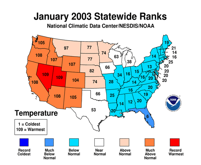
January Temperatures
larger image The graph to the left shows monthly mean temperature averaged across the contiguous United States based on long-term data from the U.S. Historical Climatology Network (USHCN). The value for 2003 is estimated from preliminary Climate Division data using the first difference approach. January 2003 ranked as the 31st warmest January in the 1895 to present record. The preliminary nationally averaged temperature was 32.9° F (0.5° C) which was 2.0° F (1.1° C) above the long-term mean.
Much above average warmth occurred in 10 western U.S. states in January with record warmth occurring in Nevada and Utah. Arizona, California and Oregon had their second warmest January on record while Idaho and Wyoming ranked 3rd warmest. Much of the remainder of the western half of the continental U.S. was also warmer than average for the month. In sharp contrast, most of the eastern half of the country (27 states) had below average temperatures for the month, with Florida falling into the much colder than average category.
As can be seen in a map of divisional temperature (below right), significantly cooler than average temperatures also occurred in Mississippi, Alabama and Ohio. In addition, many climate divisions in the west had record warm Januarys with record monthly average temperature occurring for every division in Nevada.
The pattern of warmth and cold in the contiguous U.S. in January broadly corresponded with the mean 500mb height and anomalies chart. This shows that well above normal 500mb heights extended from Mexico across the western half of the U.S., and on into northern Canada. These were associated with the much above average temperatures in January. Below average 500mb heights existed across the eastern portion of the United States leading to the lower monthly average temperatures.
It was the 18th warmest January since reliable statewide records began in 1918 for Alaska , with anomalies of 6.6°F (3.7°C) above normal relative to the period 1971-2000.
larger image 
Click here for animated image
Regional Temperature Ranks for the
Contiguous U.S., January 2003Region Rank Northeast 15th coldest / 95th warmest East North Central 64th coldest / 46th warmest Central 20th coldest / 90th warmest Southeast 13th coldest / 97th warmest West North Central 94th coldest / 16th warmest South 48th coldest / 62nd warmest Southwest 109th coldest / 1st warmest Northwest 108th coldest / 2nd warmest West 109th coldest / 1st warmest

Temperature Departures
The map below, based on over 500 airport stations, shows departures from the 1971-2000 normal temperatures for January 2003. In the lower 48 states, widespread positive departures (greater than 7.5°F [4.2°C]) occurred over much of the western U.S. Record warmth occurred in parts of this region during the last few days of January (as can be seen in an animation of daily temperature anomalies).
A new maximum daily temperature record was set in Los Angeles, CA on January 31st when the high reached 91°F (32.8°C) and Long Beach Airport reached 93°F (33.9°C) on the same day. Numerous other daily maximum temperature records were broken on January 31st over the western half of the country, including for Battle Mountain, NV (70°F/ 21.1°C), Phoenix, AZ (86°F/30°C) and Pocatello, ID (60°F/15.6°C). Many cities also had their warmest January on record including Las Vegas, NV (54.2°F/ 12.3°C) and San Jose, CA (55.6°F/13.1°C). However, records of extreme cold were broken over much of the east coast. For example, in Columbia, SC, a minimum temperature of 13°F (-10.6°C) was recorded on January 24th, tying the all-time record low for the city. Temperatures dropped as low as 17°F(-8.3°C) on the morning of the 24th in northern Florida.
larger image
See NCDC's Monthly Extremes web-page for more records.

November 2002 - January 2003 (and Dec-Jan)
larger image The graph to the left shows mean temperature averaged across the contiguous United States based on long-term data from the U.S. Historical Climatology Network (USHCN). The value for November 2002-January 2003 is estimated from preliminary Climate Division data using the first difference approach. November 2002-January 2003 was warmer than average and ranked as the 30th warmest such period in the 1895 to present record. The preliminary nationally averaged temperature for November-January was 37.1° F (2.8° C) which was 1.5° F (0.8° C) above the long-term mean.
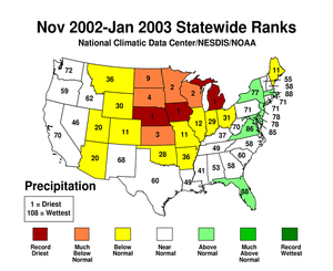
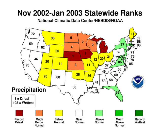
Ten states averaged much warmer than the long-term mean from November-January, and Nevada was record warm for the 3 months. Twenty-four states averaged colder than the long-term mean, though none of the contiguous U.S. states were much below normal averaged over November-January. November 2002 was a mild month with few records, so most of the November-January average can be derived from the pattern of warmth and cold in December and January as is illustrated by the 2-month temperature map below.
larger image
larger image
The average for December-January is very similar to the 3 month (Nov-Jan) average. Ten states were much warmer than average from December-January, and Nevada was record warm for the 2 months. Twenty-three states averaged colder than the long-term mean.


National Temperatures - February 2002-January 2003
larger image The graph to the left shows mean temperature averaged across the contiguous United States based on long-term data from the U.S. Historical Climatology Network (USHCN). February 2002-January 2003 ranked as the 17th warmest such period in the 1895 to present record. The preliminary nationally averaged temperature was 53.7°F (12.1°C) which was 0.9°F (0.5°C) above the long-term mean.
The contiguous U.S. was generally warm over the February 2002-January 2003 period with only 2 states (Mississippi and Arkansas) averaging significantly below normal temperature. The West and Southwest regions were 4th and 5th warmest respectively for the last 12 months, with all the states in those regions ranking in the top ten such warmest periods. In the east, only Delaware had much above average temperature during February 2002-January 2003.
larger image


January Precipitation
larger image The graph to the left is a time series depicting precipitation averaged across the contiguous U.S. Based upon preliminary precipitation data, January 2003 was much drier than average, ranking 2nd driest. This marks a return to dry conditions after a wet December .
Most states across the contiguous U.S. averaged drier than the 109-year mean for January 2003, with 7 states ranking as near average, and only 2 states which were wetter than the long-term mean. Four states (Louisiana, Arkansas, Florida and Minnesota) were record dry for January, while a further 18 states were much drier than average including Oklahoma, which was second driest in the last 109 years and 6 states (ME, GA, MS, TN, KY, and NM) that were 3rd driest. Only Washington and Idaho were significantly wetter than average with Washington state having its 10th wettest January since comprehensive record-keeping began in 1895. The drought alleviation in many eastern states, which had been reasonably sustained for the last several months, was interrupted in January, and some long-term dryness remained in Georgia and the Carolinas. For more details on drought across the country, please click on the U.S. drought page. 
larger image
Some precipitation fell as snow in January, especially in the New England region and along the east coast. More details of snowfall in January and the season so far can be found on the snow season page.


| Region | Rank |
|---|---|
| Northeast | 14th driest/ 96th wettest |
| East North Central | 3rd driest/ 107th wettest |
| Central | 5th driest/ 105th wettest |
| Southeast | 4th driest/ 106th wettest |
| West North Central | 39th driest/ 71st wettest |
| South | 3rd driest/ 107th wettest |
| Southwest | 3rd driest/ 107th wettest |
| Northwest | 84th driest/ 26th wettest |
| West | 14th driest/ 96th wettest |
 |
The graph to the left is a time series depicting precipitation from October 2002-January 2003 averaged across the Primary Hard Red Winter Wheat Belt. The growing season runs from October to February for the hard red winter wheat and preliminary data indicate that precipitation was above average for the growing season as of the end of January 2003. |
Precipitation Departures
The map below, based on more than 500 airport stations, shows January 2003 total precipitation as a percent of the 1971-2000 station normals. Above normal precipitation was generally confined to the Pacific Northwest and southern coastal Alaska. Much of the remainder of the contiguous U.S. was drier than normal.
Some of the precipitation which fell in January was in the form of snow. Click to the snow page for more details on January and the season-to-date.
Many minimum monthly precipitation records were broken in January 2003, with cities such as New Orleans and Baton Rouge, LA receiving over 5 inches (127 mm) less than average. Other towns which broke records for the driest January on record include Fayetteville, NC (0.65 in/ 16.5 mm), Little Rock, AR (0.31 in/ 7.9 mm), Los Angeles, CA (trace) and Lansing, MI (0.24 in/ 6.1 mm). Dozens of towns received their least amount of January precipitation in many years, including Tampa, FL, Flint, MI, Denver, CO and Albequerque, NM. For more records during January 2003, see NCDC's Extremes Page.
larger image

Past Two & Three Months (Dec-Jan, Nov-Jan)
larger image The graph to the left is a time series depicting precipitation averaged across the contiguous U.S. Based upon preliminary precipitation data, November 2002-January 2003 was drier than average, ranking 26th driest in the last 108 years.
Past THREE months
larger image
Past TWO months
larger image
Seven states along the eastern seaboard received slightly above average precipitation over November-January 2003. However dryness is again the story for the 3 months (Nov-Jan). Three states (Nebraska, Iowa and Michigan) received record low precipitation over the period, and 5 other states ranked in the top ten driest November-Januarys. The pattern of precipitation over the U.S. for the last 2 months appears very similar, though several strong Pacific storms in December led to above average totals in 4 western states. Dryness in January also contributed to a 2-month ranking of below average for 4 Southeastern states, and Maine, in the Northeast, fell into the much below average category for the 2 month precipitation totals.


National Precipitation - February 2002-January 2003
larger image The graph to the left is a time series depicting precipitation averaged across the contiguous U.S. Based upon preliminary precipitation data, February 2002-January 2003 was drier than average, ranking 32nd driest in the last 108 such periods. The last 4 February-January periods have averaged slightly to much below the long term mean precipitation.
Record dryness occurred in Colorado from February 2002 to January 2003. The pattern of state-averaged annual precipitation can be seen in the map to the right. Five other states ranked in the top ten driest such periods. More information on drought analysis for these states and others can be found on NCDC's Drought Pages. Despite a wetter than average fall and early winter, some residual dryness remained in the Carolinas. However, most of the Gulf states were wetter than average in part due to the moisture associated with tropical systems during the summer and fall of 2002.
larger image

