National Fall Season
Temperatures - September-November 2002
Statewide
mean temperature for the September-November period was below
average in 9 states and above average in 12 states with the
remainder averaging near-normal. None of the contiguous states
averaged much above or much below normal for the Fall season.
Over the September-November period, while no state-averaged
temperature was much cooler or warmer than the long-term mean, when
broken down by climate division, central Texas had the coolest
divisional temperature anomalies in the contiguous nation as can be
seen in the map to the right. Significantly warm divisional
temperature anomalies were confined to several divisions in the
southwest and west.
The pattern of fall temperature for the contiguous U.S. corresponds
quite well with height
anomalies in the 500mb level of the atmosphere. Though the
negative height anomalies were not large for the September-November
period, they were associated with cooler than average Statewide
temperature across the mid-section of the contiguous U.S.
Averaged over the Fall months, there were no significant positive
height anomalies in the continental US except for the extreme
northwest. But most notably, height anomalies over Alaska were
significantly greater than average and this is reflected by surface
temperatures which were warmest on record in that state for the
September-November period, as can be seen by the graph to the
right. |

larger
image
 larger
image
larger
image
|
November Temperatures

larger
image
|
The graph to the left
shows monthly mean temperature averaged across the contiguous
United States based on long-term data from the U.S. Historical
Climatology Network (USHCN). The value for
2002 is estimated from preliminary Climate Division data using the
first difference approach. November 2002 ranked as the 51st warmest November in
the 1895 to present record, which translates to near average for
the month of November. The preliminary nationally averaged
temperature was 42.6° F (5.9° C) which was 0.1° F
(0.6° C) above the long-term mean. |
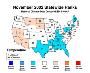
| Below average warmth
generally occurred in the southern and eastern half of the country
in November, while the western half of the country averaged slighly
above normal. No statewide mean temperature ranked much above or
much below average for the month. The east-west temperature
difference over the nation is reflected in the mean
500mb height and anomalies chart, which shows general ridging
in the west and troughing in the east. This can be translated to
cooler than average surface temperatures in parts of South and
East. The map of divisional temperature (below right) shows that
the cool anomalies were reasonably widespread in the eastern half
of the nation. Temperatures in Alaska
were record warm relative to the period 1971-2000 indicating again
the ridging over western North America. An animated image of
daily average
temperature anomalies shows the persistent warm anomalies in
the state of Alaska and variability across the rest of the
nation. |
larger
image
 larger
image
larger
image
|
Temperature
Departures
| The map to the right,
based on over 500 airport stations, shows departures from the
1971-2000 normal temperatures for November 2002. Warmer than
average temperatures extended along the west coast and in parts of
the High Plains, with the largest positive departures in the
contiguous U.S. (greater than 6.0° F [3.3° C]) occurring
in Montana. The largest negative temperature anomalies were
recorded along the east coast where widespread anomalies of
-3.0° F occurred. By far the largest anomalies occurred in
Alaska with anomalies greater than 9.0° F being recorded at
many stations. |

larger
image
|
National Fall Season
Precipitation - September-November 2002

larger
image
|
The graph to the left
is a time series depicting precipitation averaged across the
contiguous U.S. Based upon preliminary precipitation data,
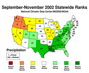
September-November 2002 was wetter than average, ranking 24th
wettest in the last 108 years. This belies considerable regional
variability as can be seen from the maps below. |
| Record high autumn precipitation occurred in
Louisiana
in 2002. Nine other states in the East also received much above
average precipitation with Mississippi
and West
Virginia having their second wettest fall on record. The
Northwest US however, received much below average precipitation
leading to a rank within the top ten driest falls for Idaho, Oregon
and Washington. |
November
Precipitation

larger
image
|
The graph to the left
is a time series depicting precipitation averaged across the
contiguous U.S. Based upon preliminary precipitation data, November
2002 was 0.25 inches drier that average, ranking 31st driest. |
| Statewide
precipitation for November was much below average in 8 states,
while only Virginia had much above average precipitation for the
month. Significant drought improvement occurred in the southwest
quarter of the country while rainfall deficits were severe in the
northern Great Plains and mid-Mississippi Valley. Several divisions
in Iowa and Illinois had their record driest November. East of the
Appalachian Mountain Range, most divisions received above or much
above average precipitation, as did most Gulf State climate
divisions. |
 larger
image
larger
image
|
Precipitation
Departures
The map to the right,
based on more than 500 airport stations, shows November 2002 total
precipitation as a percent of the 1971-2000 station normals.
Above normal precipitation generally occurred along the east coast
and in southern California. However, dryness extended across most
of the Midwest and northern Great Plains where as little as 10% of
normal rainfall was recorded in some locations. Widespread dryness
was also in evidence in the Pacific Northwest in November. |

larger
image
|


