June 2001-May 2002 Temperatures
larger image The graph to the left shows the twelve-month mean temperature averaged across the contiguous United States based on long-term data from the U.S. Historical Climatology Network (USHCN). The 2002 value is estimated from preliminary Climate Division data using the first difference approach. June 2001-May 2002 ranked as the 4th warmest such period in the 1895 to present record. The preliminary nationally averaged temperature was 54.4° F (12.4° C) which was 1.6° F (0.9° C) above the long-term mean.
Every state in the contiguous US, except Georgia, Alabama, Mississippi, Louisiana and Washington, had above average temperatures for the 12-month period. Much above normal (top ten percentile) temperatures were observed in many states in the northeast and southwest, with 6 states in the northeast ranking as the warmest June-May on record.
larger image
larger image As can be seen in the graph to the left, two-thirds of the contiguous U.S. was unusually warm in November 2001, which contributed significantly to the 12-month mean. However, at least 15% of the contiguous US has averaged very warm in all but 4 of the past 12 months.
larger image
June-May Precipitation
The graph to the left shows the twelve-month precipitation averaged across the contiguous United States. June 2001-May 2002 ranked as the 33rd driest such period in the 1895 to present record.
As can be seen in the map to the right, the last 12-months were characterized by dryness in the west and along the eastern seaboard with above average precipitation from Michigan and Wisconsin to Louisiana. Both Colorado and Arizona had their driest June-May on record, and this has resulted in extreme drought especially for Colorado. In contrast Indiana had its wettest June-May on record.
larger image


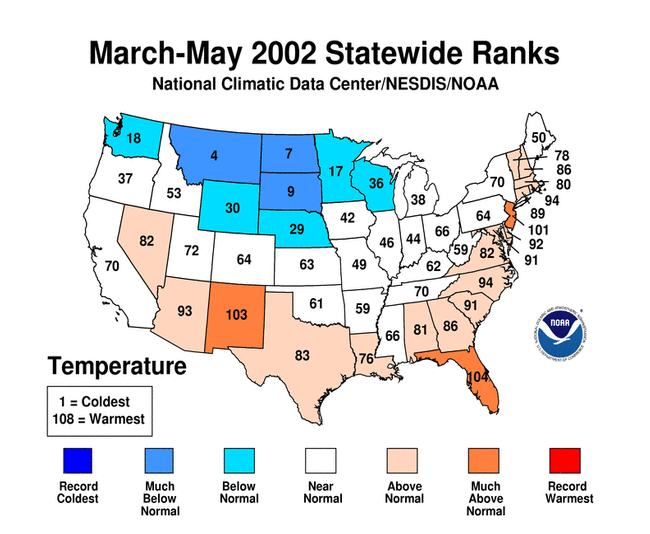
March-May Temperatures
larger image The graph to the left shows seasonal mean temperature averaged across the contiguous United States based on long-term data from the U.S. Historical Climatology Network (USHCN). The 2002 value is estimated from preliminary Climate Division data using the first difference approach. March-May 2002 ranked as the 45th warmest such period in the 1895 to present record. The preliminary nationally averaged temperature was 51.9° F (11.1° C) which was 0.1° F (0.06° C) above the long-term mean. The near-average national mean temperature for this period belies significant regional variability which is discussed below. The March-May temperature values from 1895 through 2002 are available.
Warmer than average temperatures covered much of the south while below average temperatures occurred from Wisconsin to Washington state. As is evident in the map to the right, much below average spring temperature rankings occurred in North and South Dakota and Montana. As can be seen by the spring 500mb height and anomalies map, there were significant negative anomalies over the northern tier of the country, corresponding to the unusually cool surface temperatures. However, Alaska's temperatures were above normal for the 3rd consecutive spring and averaged 0.8°C (1.4°C) above the 1961-1990 mean for March-May. Only 4 of the last 20 springs have averaged below the mean.
larger image
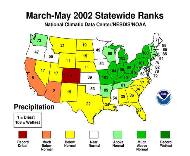
March-May Precipitation
larger image The March-May precipitation was near average for the contiguous US, ranking as 47th driest in the 1895-2002 record. However, as can be seen in the map to left, there was considerable regional variability. While many states in the central and northeastern regions received above normal precipitation, much of the west and southeast experienced continued dryness during the spring.

National Temperatures - May
larger image The graph to the left shows monthly mean temperature averaged across the contiguous United States based on long-term data from the U.S. Historical Climatology Network (USHCN). The value is estimated from preliminary Climate Division data using the first difference approach. May 2002 ranked as the 42nd coldest May in the 1895 to present record, which is slightly below average. The preliminary nationally averaged temperature was 60.6° F (15.9° C) which was 0.5° F (0.3° C) below the long-term mean. The May temperature values from 1895 through 2002 are available.
This is the first May since 1997 which has averaged below the long-term mean temperature. The May Mean 500mb Height and Anomalies chart shows large negative anomalies over Canada, spreading into the far northern states of the contiguous United States. These height anomalies are associated with below average temperatures in this region for the month. For the spring season, the pattern is similar with the addition of higher positive anomalies over the southeastern quadrant of the country, associated with greater warmth for the 3-month mean.
A more detailed analysis including how statewide and regionwide temperatures compare to other years is available.
larger image


Temperature Departures
The map to the right, based on more than 500 airport stations, shows departures from the 1971-2000 normal temperatures for May 2002. The largest negative temperature anomalies occurred around the Great Lakes and upper Midwest, but significant cold anomalies (< -1.8° F[-1° C]) occurred throughout the northern half of the country. The southeast and southwest experienced warmer than average temperatures, with the largest positive anomalies of 3.6° F (5° C) or greater from south Texas to northeastern New Mexico.
larger image
larger image Greater than normal day-to-day temperature variability is particularly noticeable in a band from the panhandle of Oklahoma to North Carolina, but above normal variability can be seen across most of the eastern half of the country. This is associated with the frequent passage of cold fronts in this region as seen both by the cold temperature departures in the map above and in an animated map of daily temperature anomalies.


National Precipitation
larger image The graph to the left is a time series depicting precipitation averaged across the nation. Based upon preliminary precipitation data, May 2002 was the 30th driest May on record. However, the month was characterized by considerable regional variability as is evident in the map below.
Missouri experienced its third wettest May on record. Much of the central and northeastern regions were wetter than average, contrasting the ongoing dryness in the southwest and much of the west and southeast. Additional details are available.
larger image


Precipitation Anomalies
The map to the right, based on more than 500 airport stations, shows May 2002 total precipitation as a percent of the 1971-2000 station normals. Above normal precipitation generally occurred from Missouri to New York, while the rest of the country was mostly dry. Especially dry were the southwestern states, as well as the Gulf coast and eastern Colorado to South Dakota.
larger image
