National Temperatures
larger imageThe graph to the left shows monthly mean temperature averaged across the contiguous United States based on long-term data from the U.S. Historical Climatology Network (USHCN). The value for 2002 is estimated from preliminary Climate Division data using the first difference approach. July 2002 ranked as the 5th warmest July in the 1895 to present record. The preliminary nationally averaged temperature was 76.4° F (24.7° C) which was 2.2° F (1.2° C) above the long-term mean. The July temperature values from 1895 through 2002 are available.
Much above average warmth occurred in 15 states across the U.S.in July. Utah had its warmest July in at least 108 years and Nevada its second warmest. July temperatures in Alaska were above normal (relative to the period 1971-2000), with the warmest July since 1997. Significantly cooler than average statewide mean temperatures were limited to Texas. The pattern of warmth and cold in the contiguous U.S. in July broadly corresponds with the mean 500mb height and anomalies chart. This shows that above normal 500mb heights existed in a broad band across the north and west of the U.S., with the largest anomalies occurring over the Great Lakes region. Cooler than average surface temperatures were associated with much above average rainfall in the far south rather than negative height anomalies. The pattern of state-averaged monthly temperature can be seen in the map to the right. A more detailed analysis including how statewide and regionwide temperatures compare to other years is available.
larger image


Temperature Departures
The map to the right, based on over 500 airport stations, shows departures from the 1971-2000 normal temperatures for July 2002. Much warmer than average temperatures extended across the whole northern tier of the country, except far northern New England, with the largest positive departures in the contiguous U.S. (greater than 6.0° F [3.3° C]) occurring in the northern and central Great Plains. The largest negative temperature anomalies were observed in the southern Great Plains of Texas and Oklahoma with some cooler than average temperatures also occurring along the southern coast of California and Florida. An animated map of daily temperature anomalies shows temperature throughout the month of July.
larger image

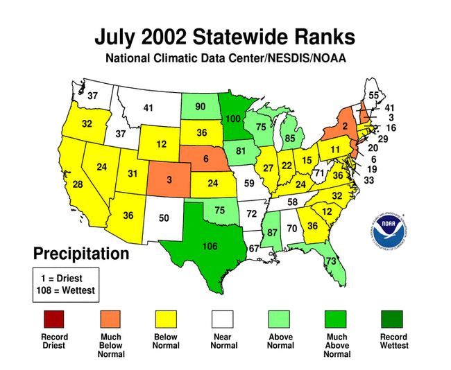
National Precipitation
larger imageThe graph to the left is a time series depicting precipitation averaged across the contiguous U.S. Based upon preliminary precipitation data, July 2002 was near average, ranking 53rd driest. July 2002 marks the second consecutive July which has been near average, nationally. There has been no significant trend in mean national July precipitation over the last century.
There was considerable regional variability in precipitation across the country. States in the Southwest U.S., central Great Plains and along the east coast received less rainfall than average in July, while states in the northern Great Plains and the South received above average rainfall this month. Two states, Minnesota and Texas, were much wetter than average for July with a rank of 3rd wettest July on record for Texas. Colorado and Nebraska were much drier than average and drought continued to worsen in these states and much of the West and Southwest. New York, New Jersey and New Hampshire were also much drier than average in July, but for New York and New Hampshire, this follows several months of wetter than average conditions. A more detailed analysis including how statewide and regionwide precipitation compares to other years is available.
larger image

Precipitation Anomalies
The map to the right, based on more than 500 airport stations, shows July 2002 total precipitation as a percent of the 1971-2000 station normals. Above normal precipitation generally occurred in the southern plains and parts of the North Central region, with more than 190% of normal precipitation falling in parts of Texas and Louisiana. While isolated stations across most parts of the country received more rainfall than normal, the dominant signal over the remainder of the contiguous U.S. was dryness, including much of the Northeast, the West, the central Plains and southeastern states excluding Florida and Mississippi.
larger image

Hurricane Season
larger imageHurricane season in the Atlantic began on June 1st. The map to the left shows sea-surface temperatures for the Atlantic averaged over the week of July 28th-August 3rd. Although much of the Gulf of Mexico and the Caribbean have sufficiently warm waters to support tropical storm development, much of the tropical Atlantic is at or below average for this time of year. As a consequence of this and a developing El Nino, scientists at NOAA's Climate Prediction Center have revised the seasonal prediction of Atlantic tropical storm activity. They are predicting that there will be 7-10 tropical storms this year (compared to 9-13 in the original outlook) of which 4-6 could develop into hurricanes and 1-3 of these hurricanes could be 'major' (category 3 or higher on the Saffir-Simpson Scale).
On average, 2 tropical storms will have formed in the Atlantic Basin by the end of July. July 2002 saw the development of Tropical Storm Arthur (shown in the satellite image to the right) which began as a tropical depression off the coast of North Carolina on July 14th and tracked northeastward becoming a tropical storm by the 16th with maximum sustained winds of 60 mph. Arthur never threatened land and there was no associated damage or death.
larger image


Wildfire Season
larger imagePartly due to ongoing drought, the western wildfire season in the U.S. has so far been both active and early compared to average. As of the end of July according to the National Interagency Fire Center, there were just over 4 million acres burned by July 31st this year. The (ten-year) average number of acres burned by the same date is not quite 2 million acres. Some of the contiguous states which have suffered the most acreage destroyed by wildfire include Arizona (nearly 630,000 acres), Colorado (~380,000 acres) and Oregon (~363,000 acres), all as of the end of July. Many states (especially Oregon) have had many more acres burned during the first couple of weeks of August. More details on this can be found on the National Interagency Fire Center's web-site and will also be available on NCDC's August State of the Climate report, available in mid-September.
While some of this year's fires were started by accident or arson, many were started by lightning, as was the case in Oregon's Sour Biscuit Fire. Most of the large fires in July occurred in Oregon, California, Idaho, Colorado, Arizona and Utah. Further information on this year's fire season can be found at the National Interagency Fire Center's web-site.
larger image


National Temperatures - January-July 2002
larger imageThe graph to the left shows seasonal mean temperature averaged across the contiguous United States based on long-term data from the U.S. Historical Climatology Network (USHCN). The value for January-July 2002 is estimated from preliminary Climate Division data using the first difference approach. January-July 2002 ranked as the 14th warmest such period in the 1895 to present record. The preliminary nationally averaged temperature was 53.5° F (11.9° C) which was 1.4° F (0.8° C) above the long-term mean.
Statewide mean temperature for the January-July period, was much above average for 15 states, with New Jersey and Delaware recording their 2nd warmest January-July on record. Above normal statewide temperatures also occurred throughout the northern and central plains, the Great Lakes region, the Ohio Valley, much of the west, the mid-Atlantic states and Florida. No state averaged significantly cooler than the long term mean over the January-July period. A more detailed analysis including how statewide and regionwide temperatures compare to other years is available.
larger image


National Precipitation - January-July 2002
larger imageThe graph to the left is a time series depicting precipitation averaged across the contiguous U.S. Based upon preliminary precipitation data, January-July 2002 was drier than average, ranking 15th driest in the last 108 years. The last 3 January-July periods have averaged below the long term mean precipitation.
Record dryness occurred in Colorado, Utah and Arizona averaged over the period January-July, 2002. Six other states in the western half of the country (CA, NV, WY, SD, NE, NM) and two in the east (NC, SC) also received much below average precipitation. One state (Wisconsin) received much above average precipitation, and 10 other states spread throughout the Great Lakes, Ohio Valley, Mississippi Valley and the Northeast also received above average precipitation over the first seven months of 2002. A more detailed analysis including how statewide and regionwide temperatures compare to other years is available.
larger image


National Temperatures - August 2001-July 2002
larger imageThe graph to the left shows monthly mean temperature averaged across the contiguous United States based on long-term data from the U.S. Historical Climatology Network (USHCN). The value for the last 12 months is estimated from preliminary Climate Division data using the first difference approach. August 2001-July 2002 ranked as the 4th warmest such period in the 1895 to present record. The preliminary nationally averaged temperature was 54.6°F (12.6°C) which was 1.8°F (1.0°C) above the long-term mean.
Record warmth occurred in 5 states (NY, NH, CT, RI, NJ) averaged over the last 12 months. The pattern of state-averaged monthly temperature can be seen in the map to the right. Twenty-five other states ranked in the top ten warmest such periods. Only 4 states maintained near-average temperatures for August-July (LA, MS, AL, AR). A more detailed analysis including climate division maps and information, and how statewide and regionwide temperatures compare to other years is available.
larger image


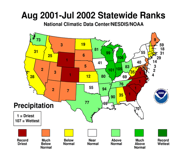
National Precipitation - August 2001-July 2002
larger imageThe graph to the left is a time series depicting precipitation averaged across the contiguous U.S. Based upon preliminary precipitation data, August 2001-July 2002 was drier than average, ranking 25th driest in the last 108 years.
Record dryness occurred in Colorado, Wyoming, Georgia, South Carolina, North Carolina and Virginia from August 2001-July 2002. Eleven other states were also much drier than average for the 12-month period. Four Great Lakes states (WI, MI, IL, IN) ranked much above average precipitation during the most recent 12 months. A more detailed analysis including how statewide and regionwide temperatures compare to other years is available.
larger image
