December-February Temperatures
larger image The graph to the left shows seasonal mean temperature averaged across the contiguous United States based on long-term data from the U.S. Historical Climatology Network (USHCN). The 2002 value is estimated from preliminary Climate Division data using the first difference approach. December-February 2002 ranked as the fifth warmest such period in the 1895 to present record. The preliminary nationally averaged temperature was 36.3° F (2.4° C) which was 3.3° F (1.8° C) above the long-term mean. Although not monotonic, winter temperatures in the US have increased approximately 1.5°F (0.8°C)/century since 1895. The December-February temperature values from 1895 through 2002 are available.
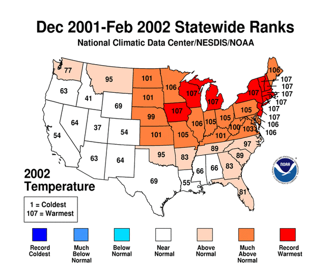
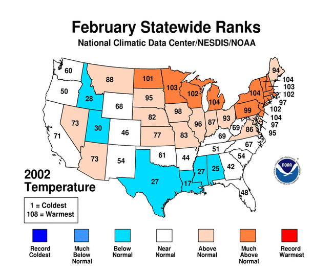
The historically warm winter season is due largely to an extensive area of much above normal temperatures, and the lack of very cold temperatures, during two of these three months. During February 2002 some colder than average state temperature ranks did occur, though even in this month, the north-central and northeast regions experienced above to much above normal temperatures. As seen in the map to the right, record warm winter temperature rankings occurred in ten states throughout the northeast quadrant of the country for the winter period. As can be seen by the winter 500mb height and anomalies map, there were significant positive anomalies over the northeast USA, corresponding to the unsually warm surface temperatures. Alaska's temperatures were also above normal for the third consecutive winter and averaged 4.7°F (2.6°C) above the 1961-1990 mean for December-February.
larger image

December-February Precipitation
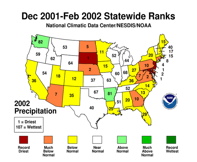 |
The December 2001-February 2002 mean precipitation was below normal for the contiguous US, ranking as 14th driest in the 1895-2002 record. However, as can be seen in the map to left, there was considerable regional variability. While many states received near normal precipitation, several states (New Jersey, South Dakota and Maryland) experienced record dryness during the winter. Below normal precipitation occurred along the entire Atlantic seaboard continuing the long-term drought conditions in many of those states. Much below normal precipitation also occurred in North Dakota and Nebraska, as well as Arizona. In contrast, above normal precipitation amounts occurred in Washington and Arkansas for December-February. |
November-February Temperatures
larger image The graph to the left shows the four-month seasonal mean temperature averaged across the contiguous United States based on long-term data from the U.S. Historical Climatology Network (USHCN). The 2002 value is estimated from preliminary Climate Division data using the first difference approach. November 2001-February 2002 ranked as the second warmest such period in the 1895 to present record. November 1999-February 2000 was the warmest November-February period on record. The preliminary nationally averaged temperature was 39.2° F (4.0° C) which was 3.8° F (2.1° C) above the long-term mean.
The anomalously warm November 2001-February 2002 period, like that for the meteorological winter, is due largely to an extensive area of much above normal temperatures (top tenth percentile), and the lack of very cold temperatures (lowest tenth percentile), during each of these four months. As seen in the graph to the right, two-thirds of the contiguous U.S. was unusually warm in November 2001, followed by approximately a quarter of the country unusually warm in December and about a fifth unusually warm in both January and February.
larger image
Aside from the very cold outbreak of November and December 2000, the last four years have been dominated by unusually warm temperatutes (see graph below left). The graph below right shows how this winter's unusual warmth fits into the pattern of the last decade. While episodes of unusually warm weather occurred during the 1990s, the frequency of cold outbreaks was greater during the first half of the decade.
larger image
larger image
Twelve states in the northeastern and north central U.S. had the warmest November-February on record in 2002. These states included Maine, New Hampshire, Vermont, Massachusetts, Rhode Island, Connecticut, New York, New Jersey, Michigan, Wisconsin, Minnesota, and Iowa. An area of much above normal temperatures extended from Maine to South Carolina, then westward to the central and northern Plains states.
larger image


National Temperatures - February
larger image The graph to the left shows monthly mean temperature averaged across the contiguous United States based on long-term data from the U.S. Historical Climatology Network (USHCN). The value is estimated from preliminary Climate Division data using the first difference approach. February 2002 ranked as the 30th warmest February in the 1895 to present record. The preliminary nationally averaged temperature was 36.8° F (2.7° C) which was 2.3° F (1.3° C) above the long-term mean. The February temperature values from 1895 through 2002 are available.
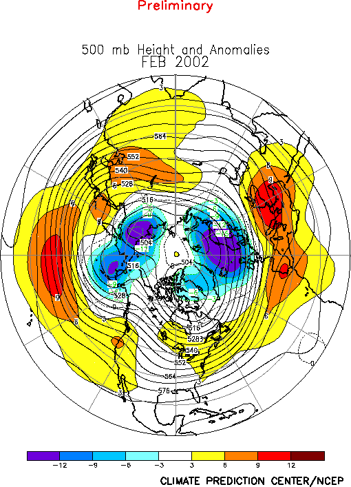
It is interesting to note that since 1995, only one year (2001) had February temperatures that were not much above average. The February Mean 500mb Height and Anomalies chart shows no large negative or postive anomalies over the contiguous United States. However, significant negative anomalies were observed over the west coast of Alaska. These height anomalies are associated with above average precipitation for the month. For the winter season, there are more substantial positive anomalies over the northeastern quadrant of the country, associated with the unusual winter warmth and dryness.
A more detailed analysis including how statewide and regionwide temperatures compare to other years is available.
larger image

Temperature Departures
The map to the right, based on approximately 250 airport stations, shows departures from the 1961-1990 normal temperatures for February 2002. The largest negative temperature anomalies occurred in northern Utah and southern Idaho, but significant cold anomalies (-1.8° F[-1° C]) occurred throughout the south-central region. Much of the rest of the contiguous states experienced unusually warm weather, with the largest positive anomalies of 9° F (5° C) or greater over the Dakotas eastward through the northeastern quarter of the country. The bulk of Alaska also had large positive anomalies.
larger image
larger image Greater than normal day-to-day temperature variability is particularly noticeable in a swath from New Mexico through Colorado, Wyoming and up into Montana and Idaho. This is associated with the unusually cool departures of monthly mean temperatures in this region as seen both in the map above and in an animated map of daily temperature anomalies.


National Precipitation
larger image The graph to the left is a time series depicting precipitation averaged across the nation. Based upon preliminary precipitation data, February 2002 was the second driest February on record following 7 months of near-normal precipitation nationally. However, considerable regional variability has occurred over the last 6 months.
New Jersey, Delaware and Maryland experienced their driest February on record. Much below normal precipitation for February is also evident in the mid-Atlantic states ranging westward into the Tennessee Valley, and northward into southern New England. Other states which experienced much below normal precipitation are the Dakotas, Nebraska, Arizona and Utah. Dryness also extends throughout most the southern half of the contiguous US. Additional details are available.
larger image


Precipitation Anomalies
The map to the right, based on approximately 250 airport stations, shows February 2002 total precipitation as a percent of the 1961-1990 station normals. Above normal precipitation generally occurred in Michigan and Wisconsin and far southeastern Florida, while the rest of the country was generally dry. Especially dry were the mid-Atlantic states, back into the Ohio/Tennessee valleys, as well as Nebraska,South Dakota and southern California and Arizona. Eastern Alaska was also dry but the west coast experienced anomalous wetness for February.
larger image

National Snow Cover
| Snow cover duration for February 2002, as observed by satellite, was well below the long-term average across the eastern and north central U.S. and in parts of the West (see map to right). Above-average snow cover duration occurred in a band across the central Plains, and in other parts of the West, especially the Pacific Northwest. |  |
|
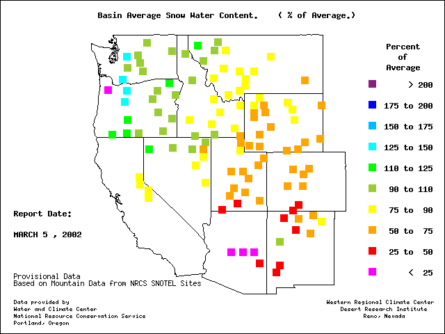
Mountain snowpack measurements in the western U.S., provided by the USDA Natural Resources Conservation Service, indicate a pattern of above average snowpack in the Pacific Northwest and below average snowpack over the rest of the Far West. The snowpack was especially low in the central Rockies and the mountains of the Southwest. Early March observations of the water content of the snow cover made by remote automated stations in the western mountains reveal a similar pattern (NRCS). End-of-February snowpack was below average across much of Alaska, but above average in the state's south central and southeastern coastal areas. The February 2002 snow cover in the north central and northeastern U.S. contrasts sharply with the February snow cover of just last year. As seen in maps from the National Weather Service North Central River Forecast Center, an end-of-February snow depth several feet deep extended from the western Great Lakes across the Upper Mississippi Valley in 2001 (see map below left). This year, a heavy snow cover existed only in the favored snow belt areas to the lee of Lake Superior (see map below right).
A similar contrast between snow depth for February 28, 2001 and February 28, 2002 is evident in the Northeast. As seen in maps from the National Weather Service Northeast River Forecast Center, a notable snow cover extended to the coast all along southern New England last year, with several feet of snow lying on the ground in northern New England (see map below left). The snow cover was largely absent this year, with only the higher elevations of the north having several feet of snow on the ground (see map below right).
The same contrast can be shown in seasonal snowfall in the Northeast. Unusually warm temperatures this winter have been accompanied by dry conditions. The drought in precipitation is reflected in less snowfall across much of the region this year (see map below right), compared to a much snowier season last year (see map below left). Less than 4 inches (10.2 cm) of snow fell in New York's Central Park from December to February, 15 inches (38.1 cm) less than normal, and snowfall in Boston, Massachusetts, was less than half of the normal 32 inches (81.3 cm). The exception was the favored snowbelt areas. The warmer than average surface water temperatures and the lack of very cold air over the Great Lakes extended the lake-effect snow season well into late winter. Heavy snow fell in the snowbelt areas of the Northeast as cold Canadian airmasses moved across the warmer than normal lakes. Marquette, Michigan, received 164 inches (416.6 cm) during the winter season and had their snowiest month on record in February. Buffalo, New York received a record 82.1 inches (208.5 cm) of snowfall in December.
|


| The long-term average snowfall for the season through the end of February can be seen in the map to the right. This map was created from the snow data available through December 2000 for 4748 stations. A comparison of the 2002 snowfall map (above right) with this climatology map shows the below-average 2002 snowfall for most of the Northeast. |  |