National Highlights:
|
Contents of this Section: |

 North American 500 Mb Maps
| The mean upper-air pattern during August was generally characterized by positive height anomalies over the northwest section of the nation. This dominating area of high pressure brought record heat to many states. As the month progressed, this high pressure area broadened its reach to encompass a large part of the country keeping the bulk of the nation warmer than normal.
Additional information on hydrometeorological analysis and forecasting can be found at the Hydrometeorological Prediction Center's Web Page. The principles behind the 500 mb flow are briefly explained here. |
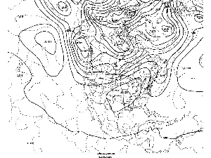 animation animation
|
National Temperatures
larger image The graph to the left shows August monthly mean temperature averaged across the contiguous United States based on long-term data from the U.S. Historical Climatology Network (USHCN). The 2001 value is estimated from preliminary Climate Division data using the first difference approach. August 2001 ranked as the fourth warmest August in the 1895 to present record. The preliminary nationally averaged temperature was 74.9° F (23.8° C) which was 2.1° F (1.2° C) above the long-term mean. The August temperature values from 1895 through 2001 are available. This is the fourth consecutive August where temperatures averaged across the nation have been above the long term mean.

Lower Tropospheric Temperatures
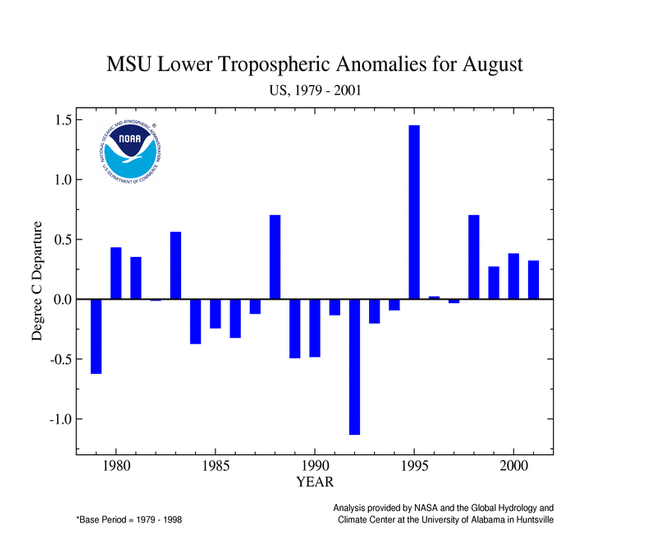
Data collected by NOAA's TIROS-N polar-orbiting satellites and adjusted for time-dependent biases by NASA and the Global Hydrology and Climate Center at the University of Alabama in Huntsville indicate that temperatures in the lower half of the atmosphere (lowest 8 km) were above average over the U.S. for August 2001. The average lower tropospheric temperature over the continental U.S. was 0.32° C (0.58° F) above the 1979-1998 mean. This was the fourth consecutive August with above average temperatures.
larger image
Temperature Departures
The map below, based on approximately 250 airport stations, shows departures from the 1961-1990 normal temperatures for August 2001.
In general, only coastal California was notably cooler than average. The bulk of the nation was warmer than normal, with the largest anomalies in the northeast and west. Warmer than average temperatures in early August were responsible for a heatwave that produced many record temperatures and were blamed for dozens of deaths. Above normal temperatures were a contributing factor in wildfires which burned over a million acres in several western states. Northern Alaska was cooler than average while southern Alaska reported warmer than normal conditions. Hawaii and Puerto Rico were near normal.
larger image Maps showing how the temperature anomalies varied day-to-day and how the day-to-day temperature variability compares to the long-term average are available. For further regional analysis, view NCDC's regional page.

Standardized Temperature Anomalies
larger image
The largest postive standardized temperature anomalies for August 2001 were generally located in the western third of the nation and in portions of the northeast. A small area of negative anomalies was located in the southeast. The adjacent animated map shows the geographical pattern of temperature anomalies for the last 12 months compared to a base period of 1931-1990. For further regional analysis, view NCDC's regional page.
National Precipitation
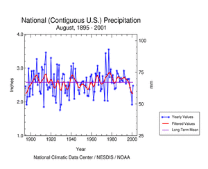
larger image The graph to the left is a time series depicting averaged precipitation across the nation. Based upon preliminary precipitation data, August 2001 was drier than average, ranking thirty-ninth in the 1895 to present record. This marks the fourth consecutive August where precipitation has been below normal. The National Precipitation Index ranked August 2001 as the thirty-second driest August.
For further regional analysis, view NCDC's regional page.
Precipitation Anomalies
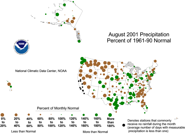
The map to the right, based on approximately 250 airport stations, shows August 2001 total precipitation as a percent of the 1961-1990 station normals. Below normal precipitation generally occurred in the west, portions of the southeast and northeast. Areas of Texas eastward to Alabama then northward to the Great Lakes, portions of Nebraska, Colorado and coastal Washington had the highest percent of normal precipitation. Puerto Rico was near normal while conditions in Alaska and Hawaii were mixed. For further regional analysis, view NCDC's regional page.
larger image
National Temperatures - Summer (June-August) 2001
larger image The graph to the left shows summer monthly mean temperature averaged across the contiguous United States based on long-term data from the U.S. Historical Climatology Network (USHCN). The 2001 value is estimated from preliminary Climate Division data using the first difference approach. Summer 2001 ranked as the fifth warmest summer in the 1895 to present record. The preliminary nationally averaged temperature was 73.6° F (23.1° C) which was 1.5° F (0.8° C) above the long-term mean. The actual summer temperature values from 1895 through 2001 are available. This is the fourth consecutive June-August where temperatures averaged across the nation have been above the long term mean.

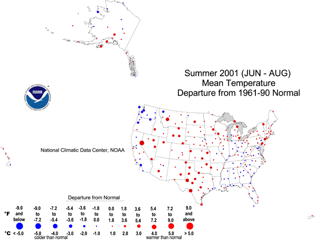
Temperature Departures - Summer
The map below, based on approximately 250 airport stations, shows departures from the 1961-1990 normal temperatures for summer 2001.
In general, the warmest temperature departures occurred in the middle third of the country, portions of Montana and Nevada and in the northeast. Only portions of the West Coast states had notable negative departures. Northern Alaska was cooler than average while southern Alaska reported warmer than normal conditions. Hawaii and Puerto Rico were near normal.
larger image
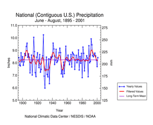
National Precipitation - Summer (June-August) 2001
larger image The graph to the left is a time series depicting averaged precipitation across the nation. Based upon preliminary precipitation data, summer 2001 was near the long term mean. Precipitation in ten of the last eleven summers have been near to or above the long term mean.
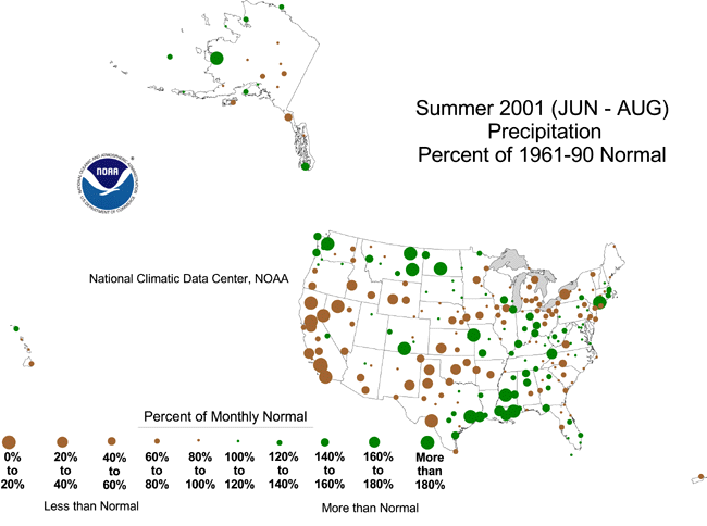
Precipitation Anomalies - Summer 2001
The map to the right, based on approximately 250 airport stations, shows summer 2001 total precipitation as a percent of the 1961-1990 station normals. Above normal precipitation generally occurred in the Pacific Northwest, from western Montana through North Dakota, parts of Colorado and Missouri, portions of the Mississippi Valley and the Gulf Coast states. Elsewhere in the country precipitation was normal to dry with very dry conditions in California, Nevada, Idaho and portions of the Southern Plains and the Great Lakes. Puerto Rico was dry while conditions in Alaska and Hawaii were mixed.
larger image
References
Current data are based on preliminary reports from River Forecast Center stations and First and Second Order airport stations obtained from the National Weather Service (NWS) Climate Prediction Center and real time Global Telecommunications System (GTS) monthly CLIMAT summaries. THE CURRENT DATA SHOULD BE USED WITH CAUTION. These preliminary data are useful for estimating how current anomalies compare to the historical record, however the actual values and rankings for the current year may change as the final data arrive at NCDC and are processed.The following NCDC datasets are used for the historical U.S. data: the climate division drought database (TD-9640), and the hurricane datasets (TD-9636 and TD-9697). It should be noted that the climate division drought database consists of monthly data for 344 climate divisions in the contiguous United States. These divisional values are calculated from the 6000+ station Cooperative Observer network.