National Highlights:
|
Contents of this Section: |
North American 500 Mb Maps
| The mean upper-air pattern during June was generally characterized by positive height anomalies over the southwestern and northeastern states and Alaska which were associated with above normal surface temperatures. A fairly persistent trough and low pressure system during the latter third of the month contributed to below normal surface temperatures in portions of the Mississippi Valley. Several low pressure systems tracking across the northwest kept Washington, Montana and North Dakota wetter than average. Additional information on hydrometeorological analysis and forecasting can be found at the Hydrometeorological Prediction Center's Web Page. The principles behind the 500 mb flow are briefly explained right here. | 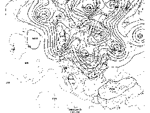 animation |
National Temperatures
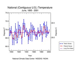 larger image |
The graph to the left shows June monthly mean temperature averaged across the contiguous United States based on long-term data from the U.S. Historical Climatology Network (USHCN). The 2001 value is estimated from preliminary Climate Division data using the first difference approach. June 2001 ranked as the twenty-fifth warmest June in the 1895 to present record. The preliminary nationally averaged temperature was 70.3° F (21.3° C) which was 1.0° F (0.6° C) above the long-term mean. This follows four consecutive years where June temperatures have averaged near the long-term mean. The actual June temperature values from 1895 through 2001 are available. |
The period April-June 2001 was the fourth warmest such period in the 1895 to present record. View the time series to see how this period compares with other years.
Lower Tropospheric Temperatures
| Data collected by NOAA's TIROS-N polar-orbiting satellites and adjusted for time-dependent biases by NASA and the Global Hydrology and Climate Center at the University of Alabama in Huntsville indicate that temperatures in the lower half of the atmosphere (lowest 8 km) resulted in the tenth coolest June in the 1979 to present record over the U.S. The average lower tropospheric temperature over the continental U.S. was 0.2° C (0.4° F) below the 1979-1998 mean. This contrasts with the previous five Junes where temperatures have been near to or above the mean. | 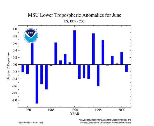 larger image |
Temperature Departures
| The map to the right, based on approximately 250 airport stations, shows departures from the 1961-1990 normal temperatures for June 2001. In general, the northwestern states and portions of the Mississippi Valley into the Gulf Coast states were cooler than normal. The rest of the contiguous United States was generally warmer than normal, especially in the southwest and northeast. Maps showing how the temperature anomalies varied day-to-day and how the day-to-day temperature variability compares to the long-term average are available. Most of Alaska reported above normal temperatures while Hawaii and Puerto Rico were near normal. For further regional analysis, view NCDC's regional page. | 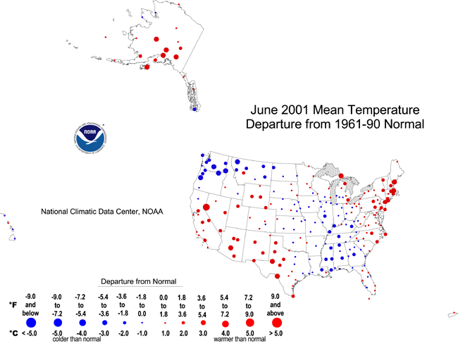 larger image |
Standardized Temperature Anomalies
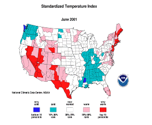 larger image |
The standardized temperature anomalies for June 2001 were positive in areas of the west and southwest, west Texas, and the northeast coast. Only the extreme northwest and portions of the Mississippi Valley had widespread negative anomalies. The adjacent animated map shows the geographical pattern of temperature anomalies for the last 12 months compared to a base period of 1931-1990. For further regional analysis, view NCDC's regional page. |
National Precipitation
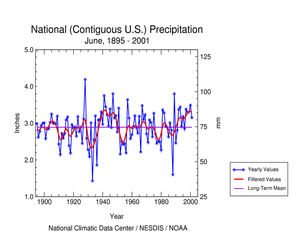 larger image |
Based upon preliminary precipitation data, June 2001 ranked as the thirty-first wettest such month since records began in 1895. This makes four consecutive Junes where precipitation has been above the long-term mean. The preliminary National Precipitation Index ranked June 2001 as the forty-fourth wettest June. Heavy rains associated with the remnants of Tropical Storm Allison eased the drought in many areas of the south and east. The system developed on the 5th in the northwest Gulf of Mexico and made landfall in southeast Texas later the same afternoon. |
Widespread flooding occurred in the Houston area with totals locally exceeding 35 inches (89 cm). The remnants of Allison emerged back into the Gulf of Mexico on the 9th and reorganized as a subtropical low pressure system before moving back inland over Louisiana on the 11th. Radar estimated precipitation across much of southeast Louisiana was 15-20 inches (38.1-50.8 cm). Heavy rains spread from the central Gulf Coast to the eastern Carolinas and into the eastern Mid-Atlantic by the 17th before Allison�s remnants merged with a cold front south of Nova Scotia on the 19th.
For further regional analysis, view NCDC's regional page.
Precipitation Anomalies
| The map to the right, based on approximately 250 airport stations, shows June 2001 total precipitation as a percent of the 1961-1990 station normals. Above normal precipitation generally occurred in the Gulf and East Coast states as well as across Washington, Montana and South Dakota. Northern portions of Hawaii and parts of far western Alaska were also wetter than normal. Below normal precipitation occurred over much of the rest of the country including most of Alaska, southern Hawaii and Puerto Rico. For further regional analysis, view NCDC's regional page. | 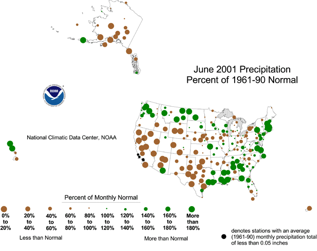 larger image |
References
Current data are based on preliminary reports from River Forecast Center stations and First and Second Order airport stations obtained from the National Weather Service (NWS) Climate Prediction Center and real time Global Telecommunications System (GTS) monthly CLIMAT summaries. THE CURRENT DATA SHOULD BE USED WITH CAUTION. These preliminary data are useful for estimating how current anomalies compare to the historical record, however the actual values and rankings for the current year may change as the final data arrive at NCDC and are processed.The following NCDC datasets are used for the historical U.S. data: the climate division drought database (TD-9640), and the hurricane datasets (TD-9636 and TD-9697). It should be noted that the climate division drought database consists of monthly data for 344 climate divisions in the contiguous United States. These divisional values are calculated from the 6000+ station Cooperative Observer network.
Questions?