National Highlights:
|
Contents of this Section: |

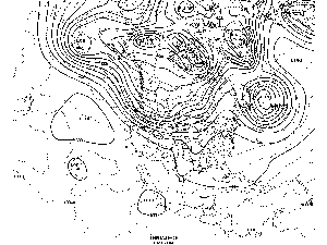
North American 500 Mb Maps
| The mean upper-air pattern during May was generally characterized by positive height anomalies over the West Coast states which were associated with above normal surface temperatures. No state in the contiguous United States experienced unusually cold temperatures. The general storm track kept the Central Plains into the western and central Great Lakes states very wet and the rest of the country dry. California, Nevada and Montana experienced very dry conditions.
Additional information on hydrometeorological analysis and forecasting can be found at the Hydrometeorological Prediction Center's Web Page. The principles behind the 500 mb flow are briefly explained here. |
 animation |
 National Temperatures
 larger image |
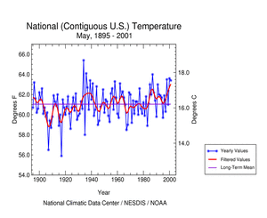
The graph to the left shows May monthly mean temperature averaged across the contiguous United States based on long-term data from the U.S. Historical Climatology Network (USHCN). The 2001 value is estimated from preliminary Climate Division data using the first difference approach. May 2001 ranked as the fifth warmest May in the 1895 to present record. The preliminary nationally averaged temperature was 63.8° F (17.7° C) which was 2.8° F (1.6° C) above the long-term mean. This was the fourth consecutive May where temperatures have averaged near to or above the long-term mean. The actual May temperature values from 1895 through 2001 are available. |
Lower Tropospheric Temperatures
| Data collected by NOAA's TIROS-N polar-orbiting satellites and adjusted for time-dependent biases by NASA and the Global Hydrology and Climate Center at the University of Alabama in Huntsville indicate that temperatures over the U.S. in the lower half of the atmosphere (lowest 8 km) were near the mean for May 2001. The average lower tropospheric temperature over the continental U.S. was 0.05° C (0.09° F) above the 1979-1998 mean. In May 2000, just one year ago, temperatures were the warmest in the 1979 to present record. This is the fourth consecutive May where temperatures have been near to or above the mean. | 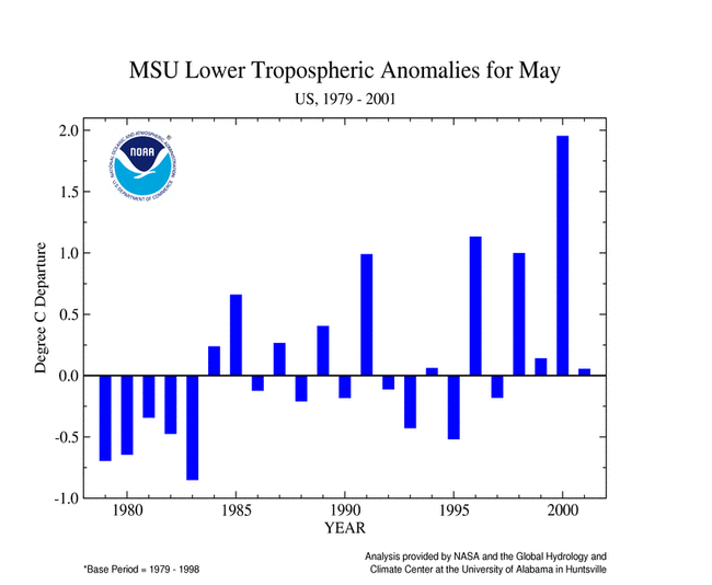 larger image |
Temperature Departures
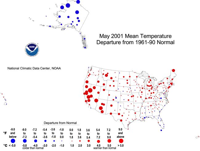
| The map to the right, based on approximately 250 airport stations, shows departures from the 1961-1990 normal temperatures for May 2001. Most of the contiguous United States was generally warmer than normal, especially in the West and Southwest regions. Maps showing how the temperature anomalies varied day-to-day and how the day-to-day temperature variability compares to the long-term average are available.
Alaska was significantly cooler than normal. For a regional analysis of conditions across the country, view NCDC's regional page. |
 larger image |
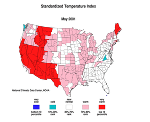
Standardized Temperature Anomalies
 larger image |
The standardized temperature anomalies for May 2001 were positive in a large portion of the western two-thirds of the nation, with the highest positive anomalies in the West and Southwest regions. Negative indices occurred only in central Virginia and the coast of Washington. The adjacent animated map shows the geographical pattern of temperature anomalies for the last 12 months compared to a base period of 1931-1990.
For a regional analysis of conditions across the country, view NCDC's regional page. |
National Precipitation
 larger image |
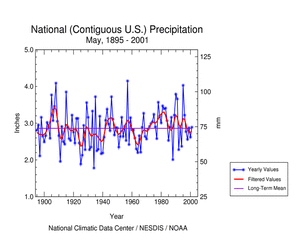
Based upon preliminary precipitation data, May 2001 ranked near the long term mean. This was the fifth consecutive May where precipitation was near to or below the long-term mean. The preliminary National Precipitation Index ranked May 2001 as the forty-seventh driest May in the 1895 to present record.
For a regional analysis of conditions across the country, view NCDC's regional page. |
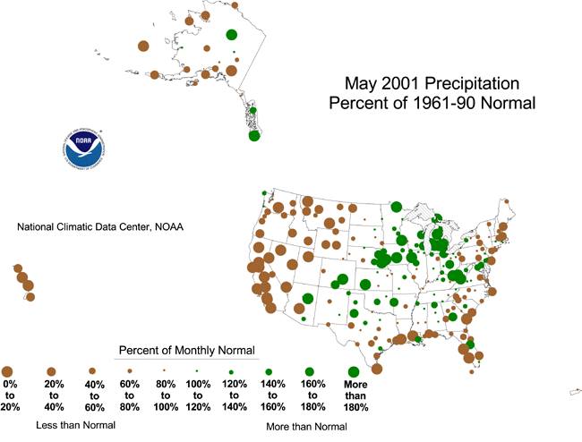
Precipitation Anomalies
| The map to the right, based on approximately 250 airport stations, shows May 2001 total precipitation as a percent of the 1961-1990 station normals. Above normal precipitation generally occurred from Arizona through the Central Plains into the Great Lakes states then southeast into West Virginia. Below normal precipitation occurred over much of the rest of the country including most of Alaska, Hawaii and Puerto Rico.
For a regional analysis of conditions across the country, view NCDC's regional page. |
 larger image |
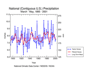
National Temperatures - Spring (March-May)
 larger image |
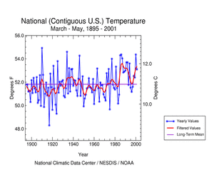
The graph to the left shows spring monthly mean temperature averaged across the contiguous United States based on long-term data from the U.S. Historical Climatology Network (USHCN). The 2001 value is estimated from preliminary Climate Division data using the first difference approach. March through May 2001 ranked as the thirteenth warmest spring in the 1895 to present record. The preliminary nationally averaged temperature was 53.5° F (11.9° C) which was 1.7° F (0.9° C) above the long-term mean. This was the fourth consecutive spring where temperatures have averaged above the long-term mean. The actual spring temperature values from 1895 through 2001 are available. |
Temperature Departures - Spring (March-May)
| The map to the right, based on approximately 250 airport stations, shows departures from the 1961-1990 normal temperatures for March-May 2001. Large negative departures were scarce. Most of the United States was generally warmer than normal, especially in the West and Southwest regions and near the Great Lakes. | 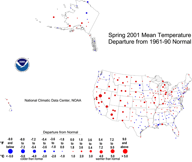 larger image |
National Precipitation - Spring (March-May)
 larger image |
Based upon preliminary precipitation data, March-May 2001 ranked near the long-term mean. Eight of the last twelve springs were near to or above the long-term mean. Precipitation extremes ranged from Maine, which had its second driest spring in the 1895 to present record, to Minnesota, which had its fourth wettest such period. |
Precipitation Anomalies - Spring (March-May)
| The map to the right, based on approximately 250 airport stations, shows March-May 2001 total precipitation as a percent of the 1961-1990 station normals. Above normal precipitation occurred in portions of western Alaska, Minnesota, northern Nebraska and southern Colorado into Arizona. Below normal precipitation occurred over much of the rest of the country including eastern Alaska and Hawaii. | 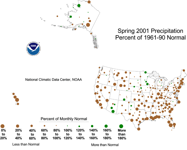 larger image |
References
Current data are based on preliminary reports from River Forecast Center stations and First and Second Order airport stations obtained from the National Weather Service (NWS) Climate Prediction Center and real time Global Telecommunications System (GTS) monthly CLIMAT summaries. THE CURRENT DATA SHOULD BE USED WITH CAUTION. These preliminary data are useful for estimating how current anomalies compare to the historical record, however the actual values and rankings for the current year may change as the final data arrive at NCDC and are processed.
The following NCDC datasets are used for the historical U.S. data: the climate division drought database (TD-9640), and the hurricane datasets (TD-9636 and TD-9697). It should be noted that the climate division drought database consists of monthly data for 344 climate divisions in the contiguous United States. These divisional values are calculated from the 6000+ station Cooperative Observer network.