 larger image |
 National Temperature - Winter
Preliminary USHCN data for winter (December 1999-February 2000) indicate the mean temperature for the three-month period averaged across the contiguous United States was much above the long-term mean and ranked as the warmest winter since 1895 (above graphic). Nearly 57% of the country was much warmer than normal while less than one percent of the country averaged much cooler than normal. Four of the last six winter seasons have been much above the long-term mean.
| The preliminary national standardized temperature index also ranked winter 1999-2000 as the warmest winter season since 1895. |  larger image |

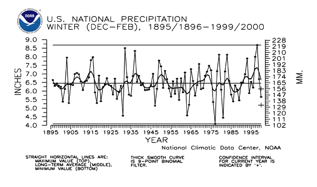
National Precipitation - Winter
 larger image |
Preliminary data for winter (December 1999-February 2000) indicate the three-month precipitation averaged across the contiguous United States was much drier than normal and ranked as the 16th driest winter since 1895. Over 12% of the country was much drier than normal while about six percent of the country was much wetter than normal. Winter 2000 was the first such season since 1989 to be much drier than normal. |
| The preliminary national standardized precipitation index ranked winter 2000 as the 30th driest winter on record. |  larger image
|
National Tornadoes
| Based on preliminary data from the National Weather Service Storm Prediction Center the count of 78 tornadoes ranked winter (December 1999-February 2000) as the tenth most active winter season since 1953-54. The 1953-1999 average winter tornado count is 59. The most active winter season was 1998-99 with 244 tornadoes while the least active winter season for tornadoes was 1984-85 with 13. |  larger image
|
Current data are based on preliminary reports from River Forecast Center stations and First and Second Order airport stations obtained from the National Weather Service (NWS) Climate Prediction Center and real time Global Telecommunications System (GTS) monthly CLIMAT summaries. THE CURRENT DATA SHOULD BE USED WITH CAUTION. These preliminary data are useful for estimating how current anomalies compare to the historical record, however the actual values and rankings for the current year may change as the final data arrive at NCDC and are processed.
The following NCDC datasets are used for the historical U.S. data: the climate division drought database (TD-9640), and the hurricane datasets (TD-9636 and TD-9697). It should be noted that the climate division drought database consists of monthly data for 344 climate divisions in the contiguous United States. These divisional values are calculated from the 6000+ station Cooperative Observer network.