Contents of This Report:

The North American 500 mb Maps for October
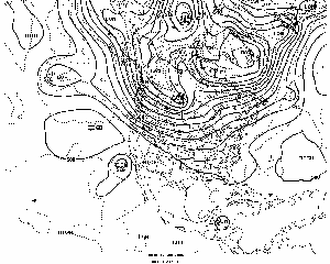
The upper-air pattern during October consisted of a trough along the Pacific coast, dominant high pressure through the Mississippi Valley region and a trough off the Atlantic Coast.
The Pacific coast trough provided below normal temperatures for the coastal states, although most coastal Oregon and Washington stations were warmer than normal. The mean upper-level ridge over the Mississippi Valley provided warmer than normal conditions for the northern and central Plains states, a good portion of the Ohio and Tennessee Valleys and parts of the Northeast. At the same time, a predominant northerly flow kept the Atlantic southeast coastal states at to slightly cooler than normal.
| The Mississippi Valley ridge kept most storm systems from reaching the eastern third of the country and provided several stations with a totally rain free month and made for the driest October on record for several mid-Atlantic States. This situation only worsened existing drought conditions in the Southeast. The return flow on the western side of the ridge, accompanied with the Pacific coastal trough, provided ample precipitation from the Southwest through the northern Plains.
|
larger animation
|
Additional information on hydrometeorological analysis and forecasting can be found at the Hydrometeorological Prediction Center's Web Page. The principles behind the 500 mb flow are briefly explained here.
 National Temperature - October
larger image
|
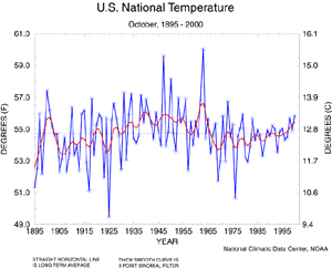
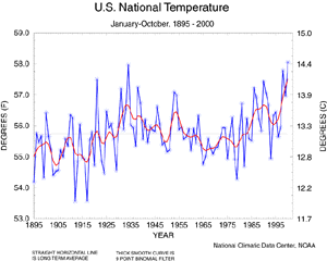
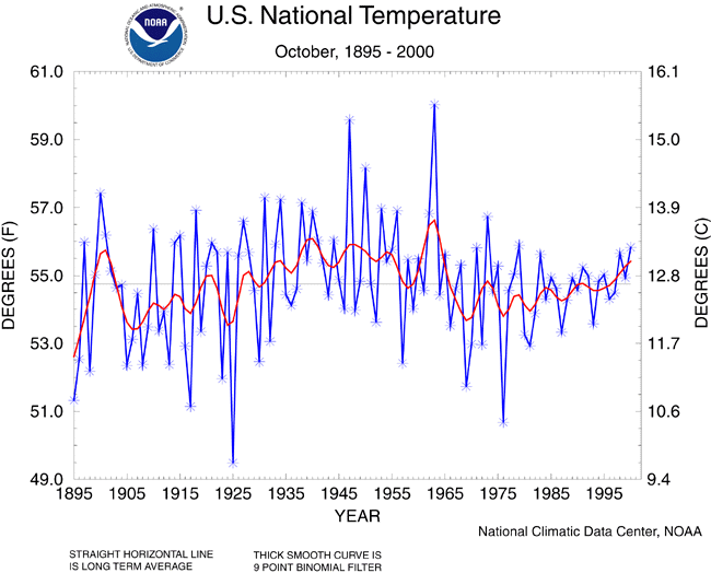
The October 2000 monthly mean temperature averaged across the contiguous United States ranked as the 25th warmest since records began in 1895. This information is based on data from the U.S. Historical Climate Network (USHCN) and preliminary data from the Climate Division Database. The preliminary nationally averaged temperature for October 2000 was 55.8° F, 1.0° F above the long-term mean. The rate of temperature increase since 1895 is 0.44° F per century and 6.3° F per century since 1976. The actual October temperature values from 1895 through 2000 are available.
|
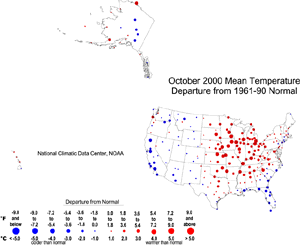
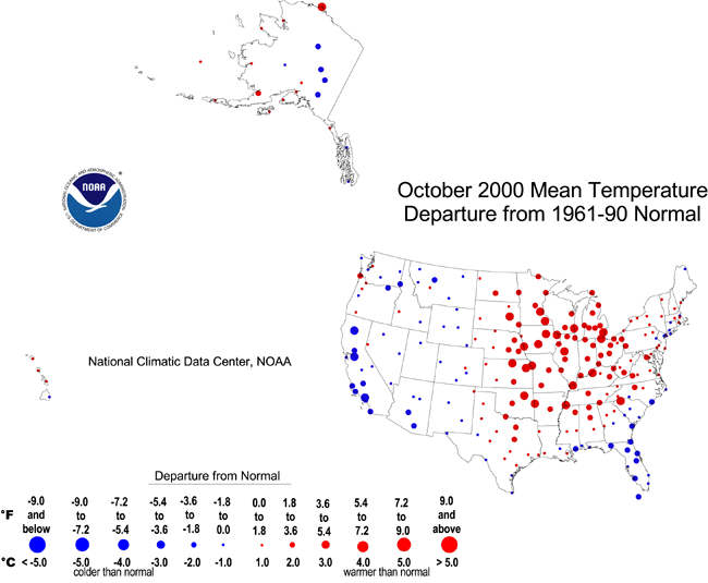
| The map to the right, based on approximately 250 airport stations, shows departures from the 1961-1990 normal temperatures for October 2000. The eastern Plains, western Great Lakes, Ohio Valley, interior mid-Atlantic, and interior Southeast were warmer than normal. The coastal Southeast and mid-Atlantic coastal regions, and from the High Plains westward, were cooler than normal. Interior Alaska was cooler than normal while the coastal sites were warmer than normal. The Hawaiian stations averaged slightly warmer than normal.
|
larger image
|
larger image
|
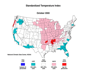
The standardized temperature anomalies for October 2000 show abnormal warmth from northern Texas to North Dakota, eastward to the Tennessee and Ohio Valleys. Very warm conditions were noted in eastern Oklahoma and the delta region of Arkansas and western Tennessee. Cooler than normal conditions are depicted along the southeast coast, portions of lower New England, southern New Mexico and Arizona, southern coastal and northern interior California and portions of the intermountain west. The map animation provided shows the geographical pattern of temperature anomalies for the last 12 months compared to a base period of 1931-1990.
|
National Precipitation - October
larger image
|
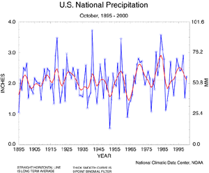
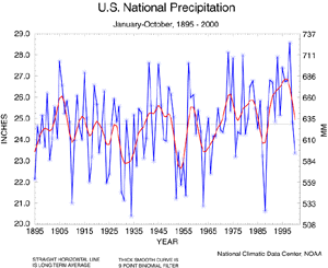
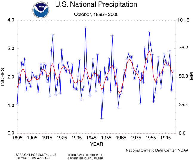
Based upon preliminary data, October 2000 ranked near normal for precipitation. Five of the last seven Octobers have been wetter than normal. The rate of precipitation increase since 1895 is 0.26 inch per century.
|
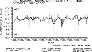
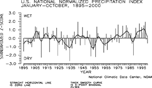
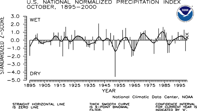
| The preliminary national standardized precipitation index ranked October 2000 as the 32nd wettest October since 1895.
|
larger image
|
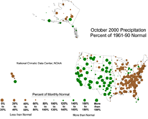
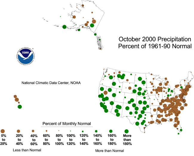
| The map to the right, based on approximately 250 airport stations, shows October 2000 total precipitation as a departure from 1961-1990 station normals. Above to much-above normal precipitation fell along portions of south coastal Alaska while the interior was drier than normal. October was much drier than normal in the northern Hawaiian stations and wetter than normal in the southern stations. On the mainland U.S., stations were predominantly wetter than normal from the central Plains westward and drier than normal from the eastern Plains to the Atlantic coast.
|
larger image
|
National Temperature - January-October 2000
larger image
|
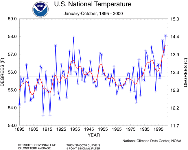
The January-October 2000 mean temperature averaged across the contiguous United States ranked as the warmest such ten-month period since records began in 1895 but only 0.08° F warmer than January-October 1934. This information is based on data from the U.S. Historical Climate Network (USHCN) and preliminary data from the Climate Division Database. The preliminary nationally averaged temperature for January-October 2000 was 58.1° F, which was 2.3° F above the long-term mean. The rate of temperature increase since 1895 is 1.0° F per century and the rate of temperature increase since 1976 is 6.7° F per century. The last three such year-to-date periods have averaged much above the long term mean. The actual year-to-date data values from 1895 through 2000 are available.
|
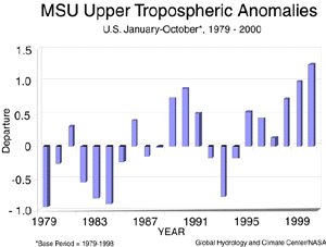
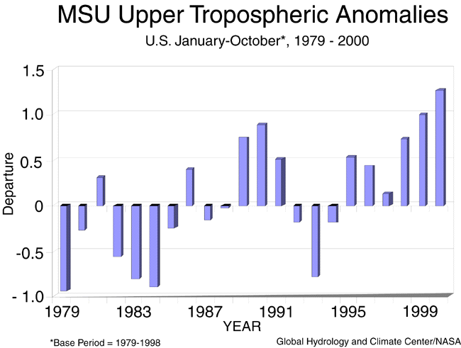
| Data collected by NOAA's TIROS-N polar-orbiting satellites and adjusted for time-dependent biases by NASA and the Global Hydrology and Climate Center at the University of Alabama in Huntsville indicate that temperatures in the lower half of the atmosphere (lowest 8 km) were the warmest on record over the U.S. for the year-to-date period (January-October 2000). The average lower tropospheric temperature over the continental U.S. during the January-October 2000 period was 1.26° F above the 1979-1998 long-term mean.
|
larger image
|
National Precipitation - January-October 2000
larger image
|
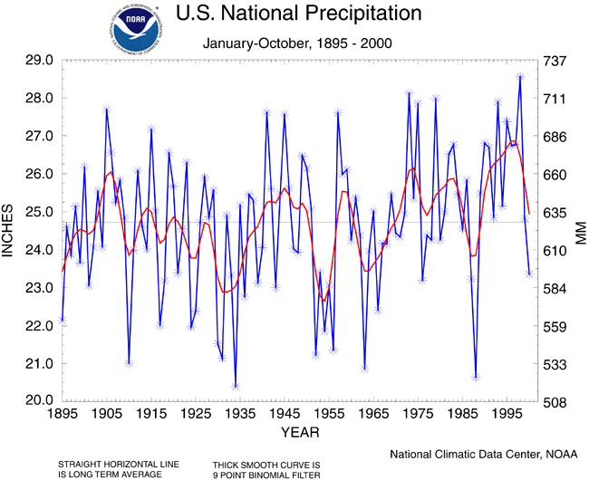
Based upon preliminary precipitation data, January-October 2000 ranked as the 24th driest such ten-month period since records began in 1895. About 14% of the country was much drier than normal, while about seven percent of the country was much wetter than normal. January-October 2000 is the first such period to average below the long-term mean since 1988. The rate of precipitation increase since 1895 is 1.22 inches per century.
|
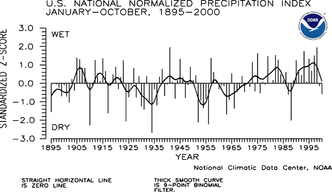
| The preliminary national standardized precipitation index ranked January-October 2000 as the 28th driest such ten-month period since records began in 1895.
|
larger image
|
Current data are based on preliminary reports from River Forecast Center stations and First and Second Order airport stations obtained from the National Weather Service (NWS) Climate Prediction Center and real time Global Telecommunications System (GTS) monthly CLIMAT summaries. THE CURRENT DATA SHOULD BE USED WITH CAUTION. These preliminary data are useful for estimating how current anomalies compare to the historical record, however the actual values and rankings for the current year may change as the final data arrive at NCDC and are processed.
The following NCDC datasets are used for the historical U.S. data: the climate division drought database (TD-9640), and the hurricane datasets (TD-9636 and TD-9697). It should be noted that the climate division drought database consists of monthly data for 344 climate divisions in the contiguous United States. These divisional values are calculated from the 6000+ station Cooperative Observer network.