 National Temperature - Spring
Preliminary USHCN data for spring (March-May 2000) indicate the mean temperature for the three-month period averaged across the contiguous United States was much above the long-term mean and ranked as the
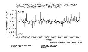
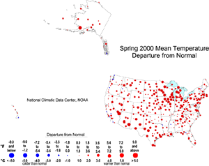
second warmest spring since 1895 (above graphic). Over 64% of the country was much warmer than normal while less than one percent of the country averaged much cooler than normal. Twelve of the last sixteen spring seasons have been above or much above the long-term mean. The preliminary
spring values are available.
| The preliminary national standardized temperature index also ranked spring 2000 as the warmest spring season since 1895. The spring 2000 value ties with that of the spring season of 1934.
|
 larger image
|
larger image
|
The map to the left, based on approximately 250 airport stations, shows departures from the 1961-1990 normal temperatures for the spring season (March-May) 2000. The entire country, except for scattered locations along the Pacific Coast and in the southeast and northeast, averaged above normal. Positive departures were greatest from the Great Lakes region through the mid-Atlantic and from the Great Basin to the western Gulf Coast. All of the Alaskan sites, except the extreme southeast, had positive departures and these were greatest in the south-central portion of the state. Hawaii was near normal.
|
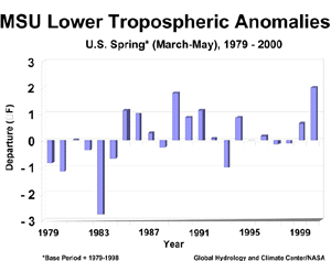
| Data provided by scientists at NASA and the Global Hydrology and Climate Center at the University of Alabama in Huntsville also indicated the presence of extremely warm temperatures in the lower half of the atmosphere (lowest 8km or 26,200 feet of the atmosphere) over the U.S. The Microwave Sounding Unit (MSU) on-board NOAA�s TIROS-N polar-orbiting satellite measured record warm temperatures during the May, spring, and January through May (year-to-date) periods. The average spring temperature anomaly was 2.0 degrees F above the long-term mean, breaking the previous record set in 1989.
|
 larger image
|

National Precipitation - Spring
larger image
|
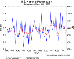
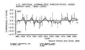
Preliminary data for spring (March-May) indicate the three-month precipitation averaged across the contiguous United States was drier than normal and ranked as the 35th driest spring since 1895. Over five percent of the country was much drier than normal while about four percent of the country was much wetter than normal. Spring 2000 was only the third such season since 1989 to average below normal for precipitation.
|
| The preliminary national standardized precipitation index ranked spring 2000 near the long-term mean.
|
 larger image
|
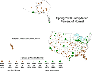
The map below, based on approximately 250 airport stations, shows spring (March-May) 2000 total precipitation as a departure from 1961-1990 station normals. Above-normal precipitation can be found in the Aleutians and the extreme southeastern portion of Alaska, while most of the other Alaskan stations, as well as the Hawaiian stations, were considerably drier than normal.
larger image
|
On the mainland U.S., stations were predominantly wetter than normal from the Northeast to the western Great Lakes, with pockets of above normal precipitation in eastern Texas, the extreme Southwest, and areas in the northern Plains and Pacific northwest. Stations were drier than normal across all of the Southeast, the mid-Mississippi Valley region, western Texas, and the intermountain West.
|
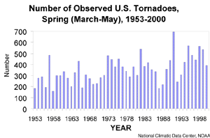
| Based on preliminary data from the National Weather Service Storm Prediction Center the count of 392 tornadoes ranked spring (March-May) 2000 as the 16th most active spring season since 1953. The 1953-1999 average spring tornado count is 352. The most active spring season was 1991 with 696 tornadoes while the least active spring season for tornadoes was 1958 with 159.
|
 larger image
|
It should be pointed out that the preliminary tornado count is traditionally higher than the final count and that the tornado observations have generally improved with time as better observing practices and instrumentation (especially weather radar and satellites) were utilized.
Current data are based on preliminary reports from River Forecast Center stations and First and Second Order airport stations obtained from the National Weather Service (NWS) Climate Prediction Center and real time Global Telecommunications System (GTS) monthly CLIMAT summaries. THE CURRENT DATA SHOULD BE USED WITH CAUTION. These preliminary data are useful for estimating how current anomalies compare to the historical record, however the actual values and rankings for the current year may change as the final data arrive at NCDC and are processed.
The following NCDC datasets are used for the historical U.S. data: the climate division drought database (TD-9640), and the hurricane datasets (TD-9636 and TD-9697). It should be noted that the climate division drought database consists of monthly data for 344 climate divisions in the contiguous United States. These divisional values are calculated from the 6000+ station Cooperative Observer network.

 larger image

 larger image

 larger image

 larger image