National Temperature - May
Preliminary data for May 1999 indicated that the monthly mean temperature averaged across the contiguous United States was near the long-term mean. Only about three percent of the country was much warmer than normal while about two percent of the country averaged much cooler than normal.
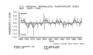
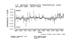
The national temperature index expresses temperature departure from the 60-year mean in terms of standard deviations. Each year's value is computed by standardizing the temperature for each of 344 climate divisions in the U.S. by using their 1931-90 mean and standard deviation, then weighting these divisional values by area.
| These area-weighted values are then normalized over the period of record. Positive values indicate warmer than the mean and negative values indicate cooler than the mean. The preliminary May 1999 national standardized temperature index also averaged near the long-term mean.
|
larger image
|
|
The May 1999 general circulation pattern consisted of a persistent trough over the western half of North America which brought unusually cool temperatures to the region during most of May. The cold anomalies helped maintain the above average snow pack in the higher elevations of the Rocky mountains and the coastal ranges. The trough extended over the adjoining Pacific Ocean, where temperatures were also cooler than average.
|
larger image
|
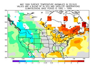
In contrast, an upper level ridge over the eastern portion of the continent, centered near the U.S. Canadian border, kept that area much warmer than usual. Further southward, temperatures were generally near the long term mean. The temperature anomaly map to the left is based on a blend of surface station data and satellite data.
|
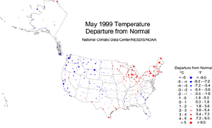
| The map to the right, based on approximately 250 airport stations, shows May 1999 average temperatures as a departure from 1961-1990 station normals. Much of the western U.S. averaged cooler than normal (blue dots) for May, while the Northeast and Great Lakes regions averaged warmer than normal (red dots). May temperatures averaged near normal over much of Alaska, with a few stations showing moderate departures. The Hawaiian stations averaged predominantly near normal.
|
larger image
|

larger image
|
The map animation to the left shows the geographical pattern of temperature anomalies for the last 12 months. On these standardized temperature anomaly maps, the color scheme ranges from blue (cold) to red (warm):
red = top 10 percentile
tan = 70-90 percentile
light blue = 10-30 percentile
dark blue = bottom 10 percentile.
|

 Temperature Variability
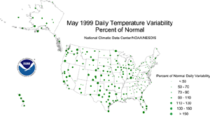
Monthly mean temperature maps show the average conditions during a month, but give no information about changes that occurred within the month. A measure of the day-to-day variability of temperature provides some insight into how temperatures changed during the month. Daily temperature variability is highly dependent on the weather systems and air masses that affect a region.
The daily difference in temperature may be lower in areas where a single air mass remains dominant. This can happen under a stable circulation pattern (at the jet stream level) that locks an air mass in place--for example, a strong zonal flow, or a stable ridge/trough pattern. The daily difference in temperature will be higher in areas that experience a greater frequency of frontal passages as cold arctic air moves southward and warmer, maritime air moves northward. This will happen under a variable circulation pattern, or along a stable storm track.
To quantify the variability in daily temperature, the average daily differences in temperature for the current month have been expressed as a ratio of the normal (1961-90) average daily difference. The magnitude of this ratio is expressed by the size of the dot representing the value at each of approximately 250 First Order airport stations across the United States. Small dots indicate that daily variability in temperature was less than normal, and may be a consequence of a dominant air mass. Large dots indicate that daily temperature variability was greater than normal reflecting a more frequent passage of differing air masses.
larger image
|
Daily temperature variability for May 1999 was above normal across much of the western and central U.S. This reflected the long-wave circulation pattern of a cold upper trough over the West, with an associated storm track across the central Great Plains into the western Great Lakes. Daily temperature variability over the eastern third of the country was generally below normal under the influence of a stagnant upper-level ridge.
|
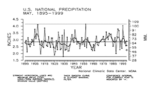
National Precipitation - May
larger image
|
May 1999 was somewhat drier than average, ranking 30th driest out of 105 years of data. Nearly seven percent of the country was much drier than normal while about five percent of the country was much wetter than normal.
|
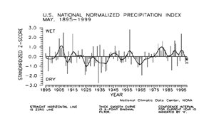
The national precipitation index expresses precipitation departure from the 60-year mean in terms of standard deviations. Each year's value is computed by standardizing the annual precipitation in each of 344 climate divisions across the U.S. using the gamma distribution over the 1931-90 period. The gamma statistical distribution takes into account heavy precipitation years and extremely dry years in the historical record (in mathematical parlance, "a zero-bounded skewed distribution"). These gamma-standardized divisional values are then weighted by area and averaged to determine a national standardized value for each year.
| These national values are normalized over the period of record. Negative values are drier and positive values are wetter than the mean. This index gives a more accurate indication of how precipitation across the country compares to the local normal (60-year average) climate.
|
larger image
|
|
The preliminary national standardized precipitation index ranked May 1999 as the 36th driest such month on record.
|
larger image
|
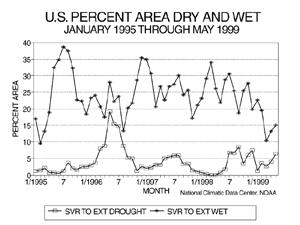
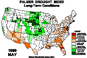
Long-term drought coverage (as measured by the Palmer Drought Index) was up slightly over April, with May 1999 having about six percent of the country in severe to extreme drought. The percent area of the country experiencing severe to extreme wetness increased slightly to about 15%.
|
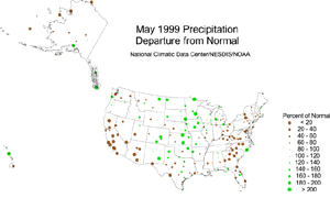
The map immediately below, based on approximately 250 First Order airport stations, shows May 1999 average precipitation as a departure from 1961-1990 station normals. La Niña brought dry conditions to much of the Southwest U.S., while the storm track across the central part of the country tapped Gulf of Mexico moisture to bring above-normal precipitation to the central and northern Great Plains.
| The upper-level ridge in the east weakened any storms that tracked into the area, inhibiting precipitation. A deflected storm track brought above normal precipitation to southern Alaska, while the rest of the state averaged below normal for May 1999. In Hawaii, the northern stations averaged wetter than normal, while the southern stations were drier than normal.
|
larger image
|
The Palmer Drought Indices
|
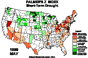
The Palmer Z Index shows how monthly moisture conditions depart from normal (short-term drought and wetness). The animated maps show the geographical pattern of the moisture anomalies for the last 12 months. On these maps, the red shading denotes dry conditions while the green shading indicates wet conditions.
|
larger image
|
larger image
|
The Palmer Drought Index Maps show long-term (cumulative) drought and wet conditions. Severe drought increased in the Southwest and along the Gulf Coast to mid-Atlantic region and into the eastern Great Lakes. The core wet areas included much of the central and northern Great Plains, and portions of the central Rockies, Pacific Northwest, and central California coast. The animated maps show how the geographical pattern of the long-term moisture conditions has changed over the last 12 months. On these maps, the red shading denotes drought conditions while the green shading indicates wet conditions.
|
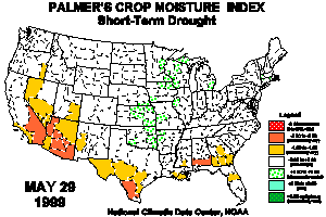
| The Palmer Crop Moisture Index is computed on a weekly basis by the National Weather Service's Climate Prediction Center and is useful for following the impact of precipitation anomalies on agriculture. The Animated Crop Moisture Index maps show the change in topsoil moisture conditions during the first 22 weeks of 1999. On these Crop Moisture Index maps, the red shading denotes dry conditions while the green shading indicates wet conditions.
|
larger image
|
Satellite-derived Analyses
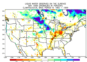
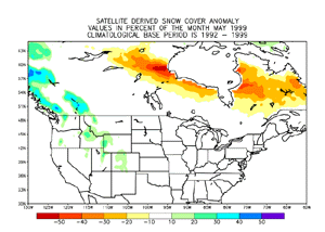
| Frequent storminess across parts of the Central Plain states led to a moisture surplus across areas from Nebraska northward to central Canada. Positive wetness anomalies were also observed across a large portion of eastern Canada east of Hudson Bay. Positive wetness anomalies across parts of eastern Canada were due to melting snowcover and most precipitation fell as rain. Portions of the eastern U.S. were drier than normal, with the southeastern U.S. from parts of Virginia to northern Florida experiencing drought conditions. These conditions are not accurately depicted in this image, since dense vegetation obscures the surface water from the satellite.
|
larger image
|
larger image
|
The snow cover anomaly map to the left reflects the overall upper-level circulation pattern over North America. The snowpack was above average over the western U.S. and western Canada beneath the cold upper trough. Mount Baker, Washington, set a new "unoffical" world snowfall record in May. In the eastern U.S. the snowpack was gone, but in eastern Canada the warm upper ridge resulted in a below-average snowpack.
|
For a look at the month's daily snow cover across North America, see the Animated North American Snow Cover Maps, May 1-31, 1999. The product is derived from NOAA/NESDIS's Satellite Services Division.
According to the USDA's National Water and Climate Center, by the end of May 1999 the snowpack remained well above average in the Pacific Northwest. Snowpacks ranged from 163 to 462 percent of average in Washington and from 273 to 310 percent of average in Oregon. The snowpack in Utah ranged from 163 to 462 percent of average.
National Temperature - January-May
larger image
|
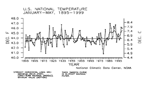
Preliminary temperature data indicate that the year-to-date, January-May 1999, was the ninth warmest January-May period since records began in 1895. About 29% of the country averaged much warmer than normal while near zero percent of the country averaged much cooler than normal. This was the second consecutive such five-month period with much-above normal temperatures.
|
| The preliminary national standardized temperature index ranked January-May 1999 as the 11th warmest January-May on record.
|
larger image
|
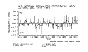
National Precipitation - January-May
larger image
|
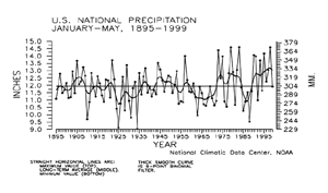
Preliminary precipitation data indicate that the year-to-date, January-May 1999, ranked near the long-term mean for nationally averaged precipitation summed across the five months. About four percent of the country was much wetter than normal for this period while about three percent of the country averaged much drier than normal. This contrasts with the second wettest such period on record which occurred just last year during the strong El Niño episode.
|
| The prelimininary national standardized precipitation index for January-May 1999 also ranked near the long-term mean.
|
larger image
|
Tornadoes - May and Year-to-date
larger image
|
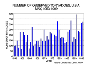
During May 1999, 324 tornadoes were documented across the contiguous United States. The 47-year average is 181. The most tornadoes observed in the May record was 391 in May 1995, while the least amount was 68 in May 1958. More information regarding May tornado statistics is located at the NCDC May Climate-Watch Page.
|
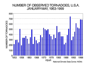
| For the year-to-date, January-May 1999, 682 tornadoes have been documented. This ranks as the third most active year-to-date, behind the count of 685 recorded just last year. The most tornadoes observed during this same five-month period is 740 in 1991 while the least amount was 191 in 1958.
|
larger image
|
It should be pointed out that the preliminary tornado count is traditionally higher than the final count and that the tornado observations have generally improved with time as better observing practices and instrumentation (especially weather radar and satellites) were utilized.
Current data are based on preliminary reports from River Forecast Center stations and First and Second Order airport stations obtained from the National Weather Service (NWS) Climate Prediction Center and real time Global Telecommunications System (GTS) monthly CLIMAT summaries. THE CURRENT DATA SHOULD BE USED WITH CAUTION. These preliminary data are useful for estimating how current anomalies compare to the historical record, however the actual values and rankings for the current year may change as the final data arrive at NCDC and are processed.
The following NCDC datasets are used for the historical U.S. data: the climate division drought database (TD-9640), and the hurricane datasets (TD-9636 and TD-9697). It should be noted that the climate division drought database consists of monthly data for 344 climate divisions in the contiguous United States. These divisional values are calculated from the 6000+ station Cooperative Observer network.


