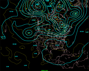
The North American 500 mb Maps for August
The dominant upper-level flow pattern during August showed a sharp trough off the California coast and a ridge covering most of the rest of the country. On several occasions a trough developed in the vicinity of the Great Lakes including a closed low from the 24th through the 27th, but it quickly lifted and the dominant ridge returned. This prevalent flow pattern allowed for cooler than normal conditions for California and the Great Lakes region and warmer to much warmer than normal conditions for the Pacific Northwest, northern Rockies, South, and Southeast.
Areas from the Rockies westward were wetter than normal, compliments of the flow from high pressure centered over the mid-south region. This flow along with the dominant Pacific coastal trough enhanced the seasonal monsoonal flow, a characteristic of the Desert Southwest during this time of year.
| Because of near-persistent high pressure, areas from Texas northeastward were drier than normal with most of the lower Mississippi valley suffering with not only one of the warmest Augusts on record, but one of the driest as well.
|
larger image
|
Additional information on drought conditions in the United States can be found on the NCDC Drought in the U.S. page. Additional information on hydrometeorological analysis and forecasting can be found at the Hydrometeorological Prediction Center's Web Page. The principles behind the 500 mb flow are briefly explained Here.

 National Temperature - August
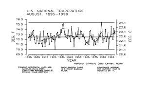
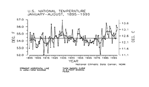
| Preliminary data for August 1999 indicate that the monthly mean temperature averaged across the contiguous United States was warmer than the long-term mean and ranked as the 23rd warmest August since 1895. About 16% of the country was much warmer than normal while less than one percent of the country was much cooler than normal.
|
larger image
|
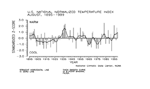
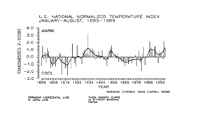
The national temperature index expresses temperature departure from the 60-year mean in terms of standard deviations. Each year's value is computed by standardizing the temperature for each of 344 climate divisions in the U.S. by using their 1931-90 mean and standard deviation, then weighting these divisional values by area.
larger image
|
These area-weighted values are then normalized over the period of record. Positive values indicate warmer than the mean and negative values indicate cooler than the mean. The preliminary August 1999 national standardized temperature index ranked August 1999 as the 16th warmest August since 1895.
|
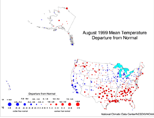
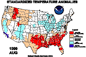
| The map to the right, based on approximately 250 airport stations, shows August 1999 average temperatures as a departure from 1961-1990 station normals. The surface temperature anomaly pattern in the contiguous states reflects the upper-level circulation pattern, as discussed above. The Alaskan stations were predominantly near to above normal, while the stations in Hawaii averaged slightly cooler than normal.
|
larger image
|
larger image
|
The map animation to the left shows the geographical pattern of temperature anomalies for the last 12 months, compared to a base period of 1931-1990. On these standardized temperature anomaly maps, the color scheme ranges from blue (cold) to red (warm):
red = top 10 percentile
tan = 70-90 percentile
white = 30-70 percentile
light blue = 10-30 percentile
dark blue = bottom 10 percentile.
|
Temperature Variability
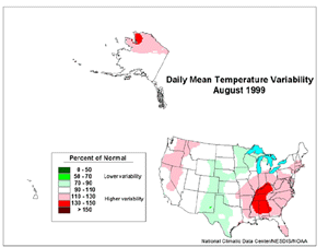
Monthly mean temperature maps show the average conditions during a month, but give no information about changes that occurred within the month. A measure of the day-to-day variability of temperature provides some insight into how temperatures changed during the month. Daily temperature variability is highly dependent on the weather systems and air masses that affect a region.
The daily difference in temperature may be lower in areas where a single air mass remains dominant. This can happen under a stable circulation pattern (at the jet stream level) that locks an air mass in place--for example, a strong zonal flow, or a stable ridge/trough pattern. The daily difference in temperature will be higher in areas that experience a greater frequency of frontal passages as cold arctic air moves southward and warmer, maritime air moves northward. This will happen under a variable circulation pattern, or along a stable storm track.
To quantify the variability in daily temperature, the average daily differences in temperature for the current month have been expressed as a ratio of the normal (1961-90) average daily difference. The magnitude of this ratio is expressed by the intensity of the shading on the map. Green shading indicates that daily variability in temperature was less than normal and may be a consequence of a dominant air mass. Red shading indicates that daily temperature variability was greater than normal reflecting a more frequent passage of differing air masses.
larger image
|
Summer weather over the southeastern U.S. is normally controlled by the stagnant Bermuda High pressure system. An unusual number of cold fronts, associated with upper-level troughs over the Great Lakes, moved through the Southeast, increasing the day-to-day temperature variability there during August 1999. Frequent cold fronts associated with an upper-level trough brought above-normal temperature variability to the West. Lower variability in the central U.S. was associated with a stagnant upper-level ridge.
|
National Precipitation - August
larger image
|
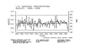
Based upon preliminary data, August 1999 ranked as the fifth driest August on record. Nearly 19% of the country was much drier than normal while about three percent of the country was much wetter than normal.
|
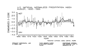
The national precipitation index expresses precipitation departure from the 60-year mean in terms of standard deviations. Each year's value is computed by standardizing the annual precipitation in each of 344 climate divisions across the U.S. using the gamma distribution over the 1931-90 period. The gamma statistical distribution takes into account heavy precipitation years and extremely dry years in the historical record (in mathematical parlance, "a zero-bounded skewed distribution"). These gamma-standardized divisional values are then weighted by area and averaged to determine a national standardized value for each year.
| These national values are normalized over the period of record. Negative values are drier and positive values are wetter than the mean. This index gives a more accurate indication of how precipitation across the country compares to the local normal (60-year average) climate.
|
larger image
|
The preliminary national standardized precipitation index ranked August 1999 as the 15th driest August since 1895.
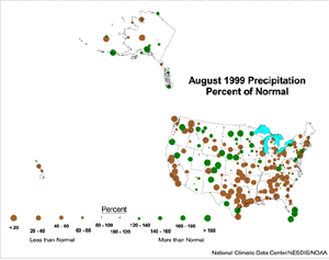
The map immediately below, based on approximately 250 First Order airport stations, shows August 1999 total precipitation as a departure from 1961-1990 station normals.
| The predominant pattern for the contiguous U.S. consisted of widespread dryness in the southern Plains to Great Lakes and eastward to the Atlantic coast. Stations were generally wetter than normal from the northern Plains to the southern Rockies. In both cases, however, there were spotty areas where the opposite pattern resulted from the convective nature of summertime precipitation. A mixed wet/dry pattern predominated over the Far West. It should be noted that percent-of-normal statistics in southern California can sometimes be exaggerated due to the normally dry summer climate there. Stations in the central Hawaiian Islands were unusually dry in August 1999, while the pattern in Alaska was mixed.
|
larger image
|
larger image
|
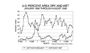
Long-term drought coverage (as measured by the Palmer Drought Index) was up considerably over July, with August 1999 having about 12% of the country in severe to extreme drought. The percent area of the country experiencing severe to extreme wetness dropped slightly to about 18%.
|
National Temperature - January-August
larger image
|
Preliminary temperature data indicate that the year-to-date, January-August 1999, was the seventh warmest January-August period since records began in 1895. About 18% of the country averaged much warmer than normal while about one percent of the country averaged much cooler than normal. Seven of the last fourteen such eight-month periods have been much above the long-term mean.
|
| The preliminary national standardized temperature index ranked January-August 1999 as the 11th warmest January-August on record.
|
larger image
|
National Precipitation - January-August
larger image
|
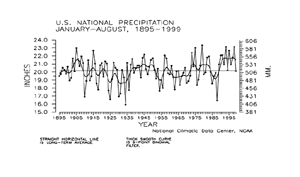
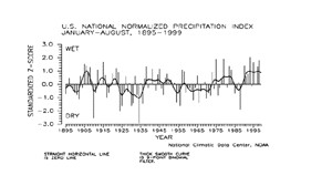
Preliminary precipitation data indicate that the year-to-date, January-August 1999, ranked near the long-term mean for nationally averaged precipitation summed across the eight month period. About five percent of the country was much wetter than normal for this period while about seven percent of the country averaged much drier than normal.
|
| The preliminary national standardized precipitation index for January-August 1999 also ranked near the long-term mean.
|
larger image
|
Tornadoes - August and Year-to-date
larger image
|
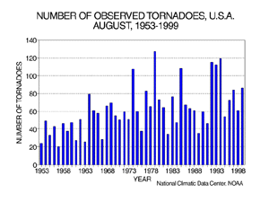
During August 1999, 86 tornadoes were documented across the contiguous United States. The 46-year average is 61. The most tornadoes observed in the August record was 127 in August 1979, while the least amount was 20 in August 1957.
|
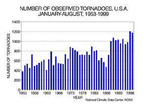
| For the year-to-date, January-August 1999, 1170 tornadoes have been documented. This ranks as the second most active year-to-date, behind the count of 1202 recorded in 1998. The least amount was 377 in 1953. The 1953-1998 mean for the year-to-date is 717.
|
larger image
|
It should be pointed out that the preliminary tornado count is traditionally higher than the final count and that the tornado observations have generally improved with time as better observing practices and instrumentation (especially weather radar and satellites) were utilized.
Current data are based on preliminary reports from River Forecast Center stations and First and Second Order airport stations obtained from the National Weather Service (NWS) Climate Prediction Center and real time Global Telecommunications System (GTS) monthly CLIMAT summaries. THE CURRENT DATA SHOULD BE USED WITH CAUTION. These preliminary data are useful for estimating how current anomalies compare to the historical record, however the actual values and rankings for the current year may change as the final data arrive at NCDC and are processed.
The following NCDC datasets are used for the historical U.S. data: the climate division drought database (TD-9640), and the hurricane datasets (TD-9636 and TD-9697). It should be noted that the climate division drought database consists of monthly data for 344 climate divisions in the contiguous United States. These divisional values are calculated from the 6000+ station Cooperative Observer network.


