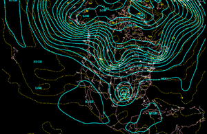
The North American 500 mb Maps for November
The month began with an upper-level closed low rotating through the southeastern states. This cold pool of air brought the season's first snowfall to the central Appalachians. The low quickly moved northeast and high pressure once again became the dominant feature across much of the country. Several upper-level troughs dropped southward from Canada into the Great Lakes and Northeast but moved quickly eastward with minimal impact on the warmer than normal temperatures. The western two-thirds of the country was dominated by high pressure nearly the entire month.
| Areas of the country from the Great Basin, eastward through the Plains, to the Atlantic coast were generally drier than normal in association with dominant high pressure. Portions of the Pacific Northwest were under the influence of a continued onshore flow, thus averaged about normal for precipitation.
|
animation
|
Additional information on hydrometeorological analysis and forecasting can be found at the Hydrometeorological Prediction Center's Web Page. The principles behind the 500 mb flow are briefly explained Here.
Twice-daily satellite images showing storm development and propagation from both GOES-8 (eastern U.S.) and GOES-9 (western U.S.) are provided.

 National Temperature - November
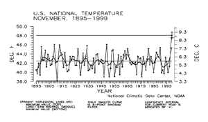
| Preliminary data for November 1999 indicated that the monthly mean temperature averaged across the contiguous United States was the warmest since 1895. The monthly mean temperature for November was 48.1F, a full two degrees warmer than the old record of 46.1F recorded in November 1949. Nearly 77% of the country was much warmer than normal while less than one percent of the country was much cooler than normal.
|
larger image
|
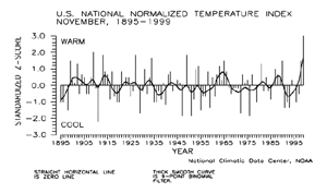
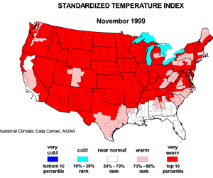
| The preliminary national standardized temperature index also ranked November 1999 as the warmest November since records began.
|
larger image
|
larger image
|
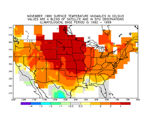
With most of the country under the influence of high pressure for a good portion of the month, positive temperature anomalies exceeded 4 degrees Celsius in portions of the Great Plains and were warmer than average from coast to coast. Only portions of Florida, the western Gulf Coast, south Texas, and the immediate Pacific Coast were near average.
|
The temperature anomaly map above is based on a blend of surface station data and satellite data.
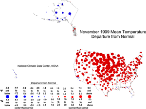
| The map to the right, based on approximately 250 airport stations, shows departures from the 1961-1990 normal of average temperatures for November 1999. Almost all of the contiguous U.S. averaged above normal, with the warmest departures occurring in the central and northern Plains states. Parts of California and the southeastern U.S. averaged near to slightly below normal.
|
larger image
|
Stations in the southeastern Alaskan panhandle averaged warmer than normal in November. Most of the rest of the stations in Alaska reported colder than normal temperatures. The Hawaiian stations were slightly cooler than normal.
animation
|
The map animation provided to the left shows the geographical pattern of temperature anomalies for the last 12 months, compared to a base period of 1931-1990.
|
Temperature Variability
larger image
|
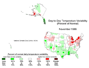
The November temperature variability map over the contiguous U.S. is shown to the left. Day-to-day variability in mean temperature was above normal from the Northeast to the Great Lakes and Ohio Valley, and in parts of the Pacific Northwest. Much of the southern third of the country experienced below-normal variability. The stations in southwestern Alaska had above-normal variability, while much of the rest of the state, as well as the Hawaiian stations, had less-than-normal variability.
|
National Precipitation - November
larger image
|
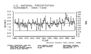
Based upon preliminary precipitation data, November 1999 ranked as the ninth driest such month since 1895. Nearly 38% of the country was much drier than normal while about one percent of the country was much wetter than normal.
|
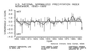
| The preliminary national standardized precipitation index ranked November 1999 as the sixth driest such month since 1895.
|
larger image
|
larger image
|
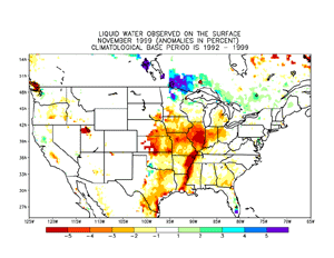
With high pressure dominating most of the country for most of the month, no major storm systems provided for significant surface wetness. Much drier than average surface conditions prevailed along the central and southern Mississippi valley, a good portion of the Midwest, parts of the central Plains, portions of southeast Texas and the Great Salt Lake valley. Pockets of above average surface wetness were noted in central Florida, parts of the mid-Atlantic and Northeast, the western Great Lakes, and areas of the Pacific Northwest. Localized convection also provided wetter than average surface conditions for extreme north-central Texas and southwestern Oklahoma.
|
The map immediately below, based on approximately 250 First Order airport stations, shows November 1999 total precipitation as a departure from 1961-1990 station normals.
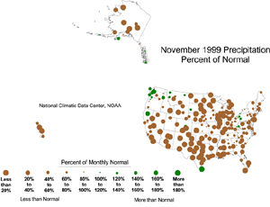
| Most of the U.S. (including the stations in Alaska and Hawaii) was drier than normal. Above-normal precipitation fell in parts of the Northwest, northern California, and the northern Rockies and in isolated areas in southern Texas and in the East. But the watchword for the nation in November was: DRY!
|
larger image
|
larger image
|
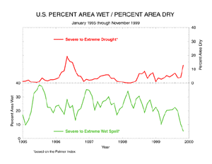
Long-term drought areal coverage (as measured by the Palmer Drought Index) increased significantly when compared to October, with November 1999 having about 13% of the country in severe to extreme drought. The percent area of the country experiencing severe to extreme wetness decreased to about five percent.
|
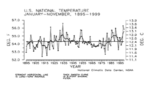
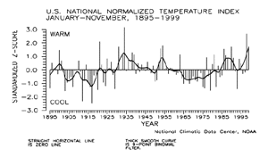
National Temperature - January-November
larger image
|
Preliminary temperature data indicate that the year-to-date, January-November 1999, was the fifth warmest January-November period since records began in 1895. About 29% of the country averaged much warmer than normal while less than one percent of the country averaged much cooler than normal.
|
| The preliminary national standardized temperature index also ranked January-November 1999 as the fifth warmest on record.
|
larger image
|
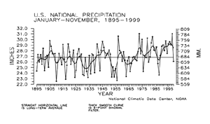
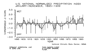
National Precipitation - January-November
larger image
|
Preliminary precipitation data indicate that the year-to-date, January-November 1999, ranked near the middle of the historical distribution for nationally averaged precipitation summed across the eleven month period. Less than one percent of the country was much wetter than normal for this period while nearly ten percent of the country averaged much drier than normal. The previous eleven such January-November periods have averaged at- to much above the long-term mean.
|
| The prelimininary national standardized precipitation index for January-November 1999 also ranked near the middle of the historical distribution.
|
larger image
|
Tornadoes - November and Year-to-date
larger image
|
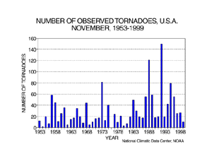
During November 1999, ten tornadoes were documented across the contiguous United States. The 46-year average is 31. The most tornadoes observed in the November record was 149 in November 1992, while no tornadoes were observed in November 1976.
|
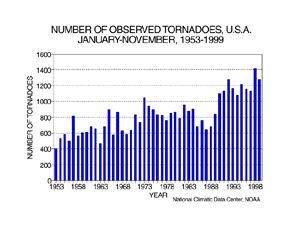
| For the year-to-date, January-November 1999, 1279 tornadoes have been documented. This ranks as the third most active year-to-date, behind the count of 1418 recorded in 1998 and 1282 in 1992. The fewest was 400 in 1953.
|
larger image
|
It should be pointed out that the preliminary tornado count is traditionally higher than the final count and that the tornado observations have generally improved with time as better observing practices and instrumentation (especially weather radar and satellites) were utilized.
Current data are based on preliminary reports from River Forecast Center stations and First and Second Order airport stations obtained from the National Weather Service (NWS) Climate Prediction Center and real time Global Telecommunications System (GTS) monthly CLIMAT summaries. THE CURRENT DATA SHOULD BE USED WITH CAUTION. These preliminary data are useful for estimating how current anomalies compare to the historical record, however the actual values and rankings for the current year may change as the final data arrive at NCDC and are processed.
The following NCDC datasets are used for the historical U.S. data: the climate division drought database (TD-9640), and the hurricane datasets (TD-9636 and TD-9697). It should be noted that the climate division drought database consists of monthly data for 344 climate divisions in the contiguous United States. These divisional values are calculated from the 6000+ station Cooperative Observer network.


