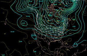
The North American 500 mb Maps for October
The dominant upper-level flow pattern during October showed a more active and variable pattern when compared to the recent summer months. This is to be expected for the transitional month of October. Several upper-level troughs dropped southward from Canada into the northern and central Plains during the month but moved quickly eastward before creating much of an impact on temperatures. The east coast, from the Carolinas northward, and the Great Lakes region were cooler than normal thanks to persistent troughs. The western two-thirds of the country, except for Washington, was warmer than normal due to prolonged periods of dominant high pressure.
| Areas of the country from the central and southern Pacific coast eastward through the eastern Plains, Ohio valley, and eastern Great Lakes were drier than normal due to high pressure and a prevalent northwesterly flow.
Coastal areas from New England through the central Gulf Coast were slightly wetter than normal.
|
animation
|
Additional information on hydrometeorological analysis and forecasting can be found at the Hydrometeorological Prediction Center's Web Page. The principles behind the 500 mb flow are briefly explained Here.

 National Temperature - October
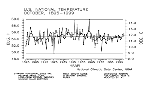
| Preliminary data for October 1999 indicated that the monthly mean temperature averaged across the contiguous United States was near the long-term mean. About six percent of the country was much warmer than normal while less than one percent of the country was much cooler than normal.
|
larger image
|
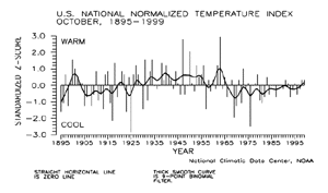
| The preliminary October 1999 national standardized temperature index ranked October 1999 near the middle of the historical distribution.
|
larger image
|
larger image
|
Several episodes of deepening upper-level troughs allowed cool air to spill down from the Canadian prairie and migrate south and eastward during October. This provided slightly cooler than average conditions for most of the country from the western Plains to the Atlantic coast. Sea surface temperatures were also slightly cooler than normal along the eastern Pacific Ocean.
|
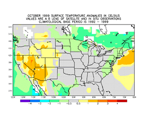
Separate ridges of high pressure dominated both the Great Basin area and the far western Atlantic. Temperatures were warmer than average in portions of central and northern California and in the Four Corners region while sea surface temperatures were warmer than average from off the Carolina coast, northward through the Canadian Maritimes. The temperature anomaly map above is based on a blend of surface station data and satellite data.
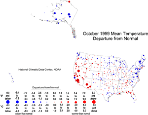
| The map to the right, based on approximately 250 airport stations, shows departures of average temperatures for October 1999. The series of upper-level troughs and associated cool Canadian air masses brought below normal temperatures to much of the mid-Atlantic to Northeast U.S., while upper ridges dominated the western third of the country bringing warmer than normal temperatures.
|
larger image
|
Average temperatures for the areas in between were a mix of slightly cooler than normal to slightly warmer than normal. The Alaskan stations were predominantly cooler than normal, and the stations in Hawaii averaged slightly cooler than normal.
The map animation above shows the geographical pattern of temperature anomalies for the last 12 months, compared to a base period of 1931-1990.
Temperature Variability
larger image
|
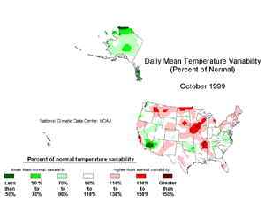
The October temperature variability map over the contiguous U.S. is shown to the left. Frequent weak frontal passages brought higher than normal daily temperature variability from the northern Rockies to the Northeast, central Plains, and lower Mississippi valley regions. Stable high pressure resulted in warm temperatures and low variability over the Southwest. Persistently cold air masses over Alaska resulted in below normal variability.
|
National Precipitation - October
larger image
|
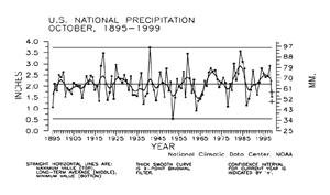
Based upon preliminary precipitation data, October 1999 ranked as the 18th driest such month since 1895. Nearly 20% of the country was much drier than normal while about one percent of the country was much wetter than normal.
|
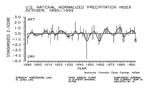
| The preliminary national standardized precipitation index ranked October 1999 as the 12th driest such month since 1895.
|
larger image
|
larger image
|
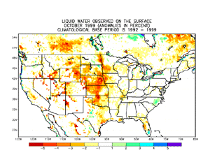
Wetness, due to coastal storms, was noted along the immediate northern Pacific Coast of the United States, but these storms quickly damped out due to prevalent high pressure covering most of the western two-thirds of the country. This dominant high pressure prevented storm systems from providing precipitation for most of the Great Plains states as well as portions of the Rockies and the Mississippi Valley, resulting in widespread areas of dry surface ground conditions. Pockets of surface wetness were noted in the eastern Great Lakes region, an area dominated by upper-level troughs, and along coastal North Carolina and southern Florida, areas impacted by Hurricane Irene.
|
The map immediately below, based on approximately 250 First Order airport stations, shows October 1999 total precipitation as a departure from 1961-1990 station normals.
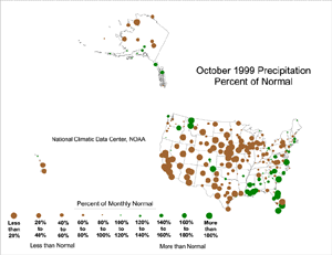
| Much of the contiguous U.S. was drier than normal. The dry area stretched from parts of the Northeast, across the Great Lakes and Great Plains, to the California coast. A few stations in the Northwest received above normal precipitation due to frontal activity, along with parts of the Southeast. Irene dumped heavy rain from southern Florida to the mid-Atlantic coast. Most of the Hawaiian stations and much of Alaska were drier than normal, while southern coastal Alaska was near normal to wetter than normal.
|
larger image
|
larger image
|
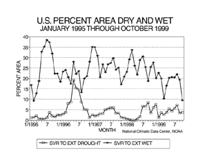
Long-term drought areal coverage (as measured by the Palmer Drought Index) remained nearly constant when compared to September, with October 1999 having about four percent of the country in severe to extreme drought. The percent area of the country experiencing severe to extreme wetness decreased sharply to about ten percent.
|
| Although dominated by high pressure during the month, several upper-level troughs and at least one closed low moved over the central and southern Rockies and provided snowfall to areas as far south as central New Mexico during October 1999. A clipper-type storm system gave portions of the northern Plains their first snow of the season early in the month while all of the east except isolated areas in New Hampshire and Maine remained free of snowcover the entire month.
|
larger image
|
In north central and northeastern Canada, the typical southerly progression of snowcover was becoming more evident.
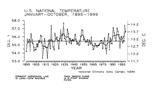
National Temperature - January-October
larger image
|
Preliminary temperature data indicate that the year-to-date, January-October 1999, was the tenth warmest January-October period since records began in 1895. About 19% of the country averaged much warmer than normal while less than one percent of the country averaged much cooler than normal.
|
| The preliminary national standardized temperature index ranked January-October 1999 as the 12th warmest January-October on record.
|
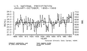
National Precipitation - January-October
larger image
|
Preliminary precipitation data indicate that the year-to-date, January-October 1999, ranked near the middle of the historical distribution for nationally averaged precipitation summed across the ten month period. About four percent of the country was much wetter than normal for this period while about five percent of the country averaged much drier than normal. The last eleven such ten-month periods have averaged at- to much above the long-term mean.
|
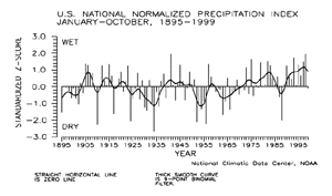
| The prelimininary national standardized precipitation index for January-October 1999 also ranked near the middle of the historical distribution.
|
larger image
|
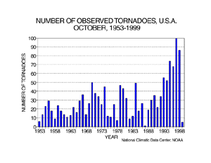
Tornadoes - October and Year-to-date
larger image
|
During October 1999, five tornadoes were documented across the contiguous United States. The 46-year average is 30. The most tornadoes observed in the October record was 100 in Ocotober 1997, while the least amount was one in October 1987.
|
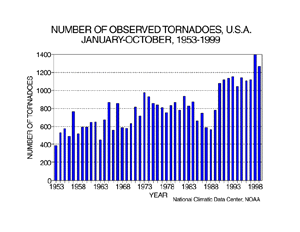
| For the year-to-date, January-October 1999, 1262 tornadoes have been documented. This ranks as the second most active year-to-date, behind the count of 1392 recorded in 1998. The least amount was 388 in 1953.
|
larger image
|
It should be pointed out that the preliminary tornado count is traditionally higher than the final count and that the tornado observations have generally improved with time as better observing practices and instrumentation (especially weather radar and satellites) were utilized.
Current data are based on preliminary reports from River Forecast Center stations and First and Second Order airport stations obtained from the National Weather Service (NWS) Climate Prediction Center and real time Global Telecommunications System (GTS) monthly CLIMAT summaries. THE CURRENT DATA SHOULD BE USED WITH CAUTION. These preliminary data are useful for estimating how current anomalies compare to the historical record, however the actual values and rankings for the current year may change as the final data arrive at NCDC and are processed.
The following NCDC datasets are used for the historical U.S. data: the climate division drought database (TD-9640), and the hurricane datasets (TD-9636 and TD-9697). It should be noted that the climate division drought database consists of monthly data for 344 climate divisions in the contiguous United States. These divisional values are calculated from the 6000+ station Cooperative Observer network.


