| Severe to extreme
drought was widespread throughout much of the western United
States. The most concentrated areas of extreme to exceptional
drought classification were across the Northern Rockies and parts
of New Mexico. Severely dry conditions along the immediate West
Coast were alleviated by heavy rain and snow during late December
2003 and into February 2004. |

larger
image
|
For complete drought analysis throughout the United States,
please see the U.S.
regional drought pages.

larger
image
|
A dust storm
originating from the Sahara Desert affected much of Chad and Niger
on February 11 with severely reduced visibilities. |
| Long term drought
continued across areas of Africa, including the Greater Horn and
parts of Southern Africa (WFP). In South Africa, at least 4 million
people were in need of immediate assistance due to the ongoing
drought (IRIN). The Lesotho Prime Minister declared a food
emergency for the country on the 11th, with projections that as
many as 700,000 people would require food aid in the coming months
(AFP/WFP). |
 larger
image
larger
image
|


larger
image
|
Heavy rains that began
in December across areas of Brazil continued
through January and into early February. Mudslides and floods
left tens of thousands of people homeless and resulted in 161
deaths since heavy rains began in late December 2003 (BBC
News/Reuters). The worst-affected areas included
the northeastern states of Pernambuco, Bahia and Piaui. |
Heavy rains produced flooding in the United Kingdom on February
3rd, specifically across areas of Wales. The villages of Llanrwst
and Trefriw in the Conwy Valley were among the worst affected
areas. Floodwaters cut off the village of Trefriw, stranding
residents for nearly two days (BBC News).
For an archive of flood events worldwide, see the
Dartmouth Flood Observatory.

A severe storm affected much of central New Zealand on the 15th
as high winds and heavy seas damaged roads and buildings in
Auckland and Wellington. Ferry traffic between the North and South
islands was also suspended (AFP).

| Tropical Cyclone
Elita first
affected Madagascar in late January as it moved into the northern
part of the country on the 28th. Elita moved southwest parallel to
the coastline before drifting back out over the Mozambique Channel
on February 1. The cyclone re-strengthened and made a second
landfall on the 3rd near the town of Morondava. Maximum sustained
winds at the time of landfall were near 120 km/hr (65 knots or 75
mph). Elita crossed the island nation and exited along the east
coast. At least 29 people were killed and 44,000 left homeless
(NASA/TRMM/AFP). |
 larger
image
larger
image
|
 larger
image
larger
image
|
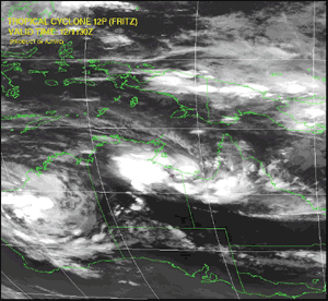
Tropical Cyclone
Fritz formed
on the 9th in the Coral Sea and moved across Australia's Cape York
Peninsula in Queensland as a depression. Fritz then moved into the
Gulf of Carpentaria and attained maximum sustained winds of 65
km/hr (35 knots or 40 mph) before moving ashore near the
Queensland/Northern Territory border on the 12th. The tropical
cyclone produced locally heavy rains along its path across areas of
Queensland and the Northern Territory. |
| Tropical Cyclone
Monty
developed in the Indian Ocean on the 27th. The cyclone reached peak
intensity over open waters on February 29 about 315 km (195 miles)
north-northeast of Learmonth, with maximum sustained winds near 205
km/hr (110 knots or 125 mph). The storm weakened as it made
landfall on the first of March near Mardie, Australia producing
torrential rainfall and packing maximum sustained winds near 175
km/hr (95 knots or 110 mph). |
 larger
image
larger
image
|
 larger
image
larger
image
|
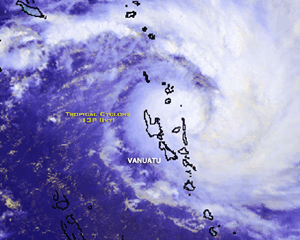
Tropical Cyclone
Ivy
developed in the South Pacific Ocean on the 22nd and crossed the
island chain of Vanuatu around the 24th with maximum sustained
winds near 160 km/hr (85 knots or 100 mph). At least one person was
killed from the storm and many homes and crops were damaged
(AFP). |
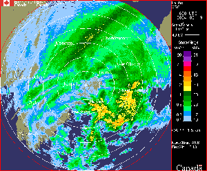
| An intense
low-pressure system brought blizzard conditions to the maritime
provinces of southeastern Canada during February 19. Across Nova
Scotia, more than 65 cm (25 inches) of snow accumulated through
parts of the province. |
 larger
image
larger
image
|
 Click
for Animation
Click
for Animation
|
Radar imagery courtesy
of
Environment Canada depicted the heavy snow bands, and surface
weather reports indicated severely reduced visibilities and wind
gusts over 100 km/hr (60 mph) across parts of Nova Scotia and
Prince Edward Island. The Nova Scotian minister of emergency
measures indicated that the storm "practically shut down the entire
province" and resulted in the first ever "Code Black" issuance by
goverment officials (Reuters/CBS News). High tides and a
significant 1-meter (3.3 foot) storm surge brought coastal flooding
to some communities. |

 Click
for Animation
Click
for Animation
|
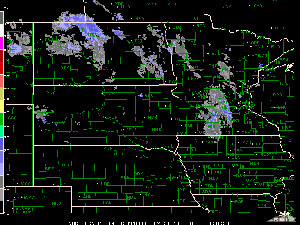
In the United States,
strong winds, heavy snow and cold temperatures combined to produce
blizzard conditions through areas of the Dakotas and western
Minnesota on February 11. |
| Winds gusting over 110
km/hr (70 mph) along with heavy snow produced low visibilities and
drifts up to 20 feet in northwestern North Dakota. Governor John
Hoeven declared a snow emergency, and Amtrak train service was
interrupted in the region (CNN). |
 larger
image
larger
image
|
In the United States, piedmont areas of the Carolinas received
exceptionally heavy snow on February 26. Locally up to 51 cm
(20 inches) of snow accumulated in the Charlotte metropolitan area.
It was Charlotte's third largest snowstorm on record, with 33.5 cm
(13.2 inches) observed at the airport.
A winter storm brought heavy snowfall to much of the eastern
Mediterranean region, from Greece eastward into parts of the Middle
East. Southern Greece received heavy accumulation of snow which
closed many regional airports, including the Athens International
Airport on the 13th (AFP). Farther east, strong winds and high seas
caused the sinking of two ships off the coast of Turkey. An
avalanche was blamed for three deaths in a small village in the
southeastern part of the country (AFP). Heavy snow blanketed areas
of the Middle East, including parts of Lebanon, Jordan and Syria.
Three deaths were blamed on the storm in Lebanon and Jordan, where
up to 61cm or 2 feet of snow accumulated (USA Today/AFP).
Additional wintry weather affected a large area of western
Europe during the last week of February, including parts of France,
Germany, Belgium and Spain. Significant transportation impacts were
reported, as heavy snowfall caused many traffic accidents and
travel delays.
References:
Basist, A., N.C. Grody, T.C. Peterson and C.N. Williams, 1998:
Using the Special Sensor Microwave/Imager to Monitor Land Surface
Temperatures, Wetness, and Snow Cover. Journal of Applied
Meteorology, 37, 888-911.
Peterson, Thomas C. and Russell S. Vose, 1997: An overview of
the Global Historical Climatology Network temperature data base.
Bulletin of the American Meteorological Society,
78, 2837-2849.
|


