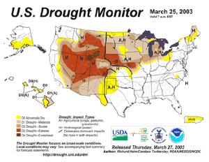
| While beneficial
precipitation fell throughout parts of the Western United States
during March, severe to exceptional drought continued throughout
much of the Intermountain region and into areas of the Great Plains
eastward into the southern Great Lakes. For detailed information on
drought conditions in the United States, see the March drought
pages. |
larger image |
 larger
image larger
image |
Across New Zealand, a
prolonged dry spell brought drought and high fire danger to much of
the country (New Zealand Herald). |

| The remnants of
Tropical Cyclone Japhet, which moved into Mozambique on the 2nd,
brought heavy rains to the region during the first week of March.
Parts of Mozambique, Malawi and Zimbabwe experienced strong gusty
winds and locally torrential rainfall, which produced areas of
flooding. In Mozambique, over 50,000 people were affected, leaving
thousands cut off from desperately needed food supplies (WFP). |

larger image |
 larger
image larger
image |
In Malawi, flooding
rains around the 10th damaged a major power station, causing
widespread power failures and water shortages in the country's two
main cities (Associated Press). The areas affected by heavy
precipitation and flooded are visible in the figure of surface
wetness. |
In South Africa, two separate storm systems brought heavy rain
to Western Cape Province during the 18th-19th and again during the
24th-25th. Rainfall totals locally exceeded 200 mm (7.87 inches),
which produced extensive flooding throughout the province.
Heavy rain and snow which began in February 2003 continued in
early March across areas of Afghanistan and Pakistan. The
precipitation provided relief to this region, which has suffered
through drought for the past four years. Afghanistan's head of the
Hydrology and Water Control Department said that recent snow and
rainfall had restored the country's water resources to 75 percent
of their normal levels (ENS).
| Heavy rainfall
continued during March 17-23 across areas of northern Afghanistan,
producing flooding in parts of Samangan and Kunduz provinces. The
flooding was responsible for at least 11 deaths and damaged or
destroyed hundreds of homes (Associated Press). |

larger image |
In South America, heavy rains on the 20th in Colombia's
mountainous coffee-growing region caused mudslides which damaged
dozens of homes and killed 11 people in the city of Manizales,
located about 160km (100 miles) northwest of Bogota. In Villamaria,
four people were killed by mudslides, while 4 other people drowned
in flooding along the eastern border city of Cucuta
(Disasterrelief.org).
For an archive of flood events worldwide, see the
Dartmouth Flood Observatory.

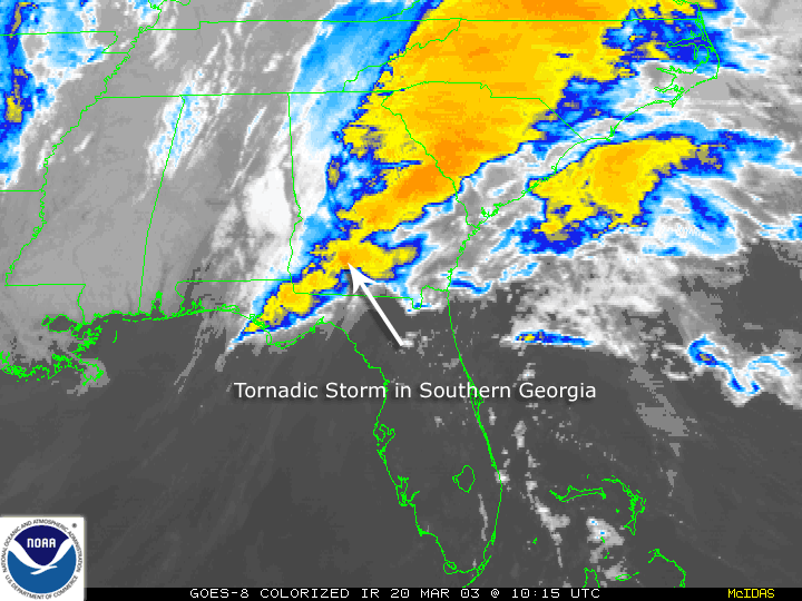
Farther south in Florida, severe thunderstorms and tornadoes
killed one and injured eight on the afternoon of March 28.
 larger image
 |
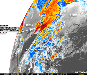
Severe thunderstorms
affected eastern India on the 12th and resulted in 30 deaths and
500 injuries in the state of West Bengal (OCHA/Associated Press).
Strong winds and hail uprooted trees, flattened hundreds of homes,
killed thousands of cattle and poultry and damaged crops in the
Howrah, Bankura and Hooghly districts of West Bengal state. |
Thunderstorms which affected eastern India late on the 12th also
affected adjacent areas of Bangladesh on the 14th. Winds gusting to
100 km/hr (~55 knots or 60 mph) leveled more than 500
mud-and-thatch huts leaving thousands homeless and 50 injured in
the Magura district (Associated Press).

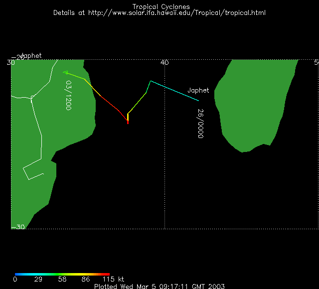
| Tropical Cyclone
Japhet
developed off the west coast of Madagascar on the 26th and tracked
slowly westward across the Mozambique Channel. The cyclone moved
into southern Mozambique on the 2nd with maximum sustained winds
near 160 km/hr (85 knots or 95 mph). Strong winds and heavy rains
exceeding 190 mm (7.5 inches) were reported in parts of Mozambique,
with the most severe conditions noted in the southern Inhambane
province. |

larger image |
 larger image
 |
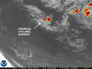
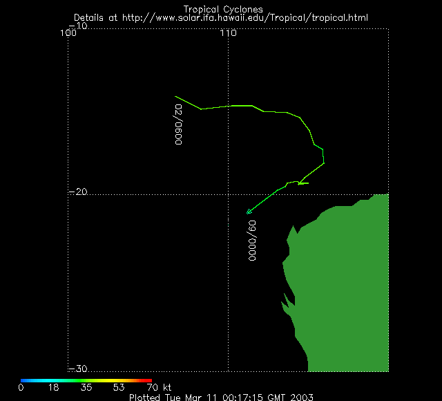
Tropical Cyclone
Harriet
developed in the South Indian Ocean on the 2nd and was located
about 330 km (~210 miles) northeast of Learmonth, Australia on the
6th with maximum sustained winds near 65 km/hr (35 knots or 40
mph). The system dissipated offshore by the 9th, but tracked close
enough to shore to bring locally heavy showers and gusty winds to
coastal areas of Western Australia. |
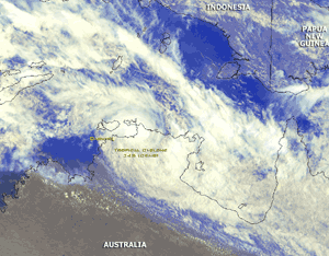
| Tropical Cyclone
Craig
developed in the Timor Sea on the 8th and made landfall in the
Australian Northern Territory approximately 185 km (115 miles) east
of Darwin on the 11th. Maximum sustained winds were near 65 km/hr
(35 knots or 40 mph) as the storm came ashore. Heavy rainfall
accompanied Craig as it moved slowly southeastward, finally
dissipating over northern Queensland on the 12th. |
larger image |
 larger image
 |
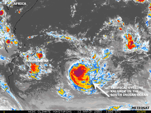
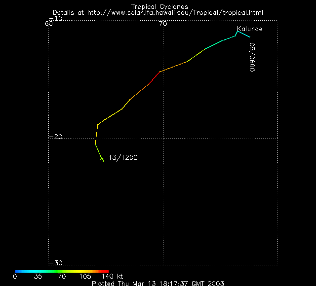
Tropical Cyclone
Kalunde
developed in the Indian Ocean on the 5th and passed across
Rodrigues in the Mascarene Islands on the 12th with maximum
sustained winds near 195 km/hr (105 knots or 120 mph). The cyclone
dissipated over open waters of the southern Indian Ocean on the
15th. |
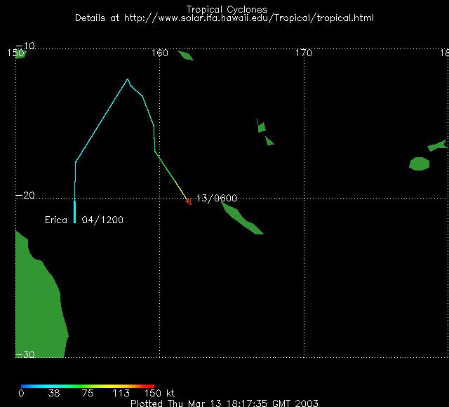
| Tropical Cyclone
Erica
developed over the Coral Sea on the 4th and crossed New Caledonia
on the 13th with maximum sustained winds near 185 km/hr (100 knots
or 115 mph). Erica caused two deaths on the island along with 100
injuries and an estimated 1,000 homeless (OCHA). The storm made
landfall near Kone and produced the most significant damage along
the west coast, including the capital city of Noumea. |

larger image |
 larger image
 |
A powerful storm
system moved across the Mediterranean Sea and affected Greece on
March 17. The storm produced wind damage and power outages, with
heavy snowfall in the southern Peloponnesian region (Associated
Press). Hurricane-force winds also swept through parts of the
Aegean Sea. This same weather system brought gusty winds and
associated dust storms to areas of northern Saudia Arabia, Kuwait,
and southern Iraq during the 18-19th. |
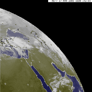
| A strong storm system
crossed the eastern Mediterranean and affected the Middle East
during March 24-26, bringing a variety of precipitation types to
the region. In Israel, Jerusalem reported a mix of rain and snow on
the 25th, while strong winds produced severe sandstorms over large
portions of Saudia Arabia, Iraq and Kuwait during the
25th-26th. |
Click for Animation |
In addition to near-zero visibilities and strong winds gusting
over 75 km/hr (40 knots or 45 mph), showers and thunderstorms
preceded a strong cold front which swept across areas of eastern
Iraq and Kuwait, severely affecting U.S. and coalition military
operations in the area. Strong thunderstorms produced large hail
that damaged some coalition aircraft flying missions in the Persian
Gulf (CNN).

| A Pacific storm
system, which moved into the northwestern United States during the
5th-6th, brought locally heavy rain and mountain snow to
drought-affected areas of the Rockies. Numerous warnings for heavy
snow were in effect on the 6th. |

larger image |
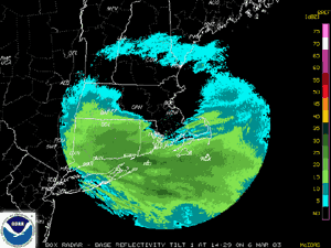 Radar Animation
 |
Another in a series of
winter storms that affected the Northeast United States during the
2002-2003 winter season brought snow to the area on March 6th. Snow
accumulations of 15-25 cm (6-10 inches) were common across parts of
Massachusetts, Rhode Island, Connecticut and westward into the
Poconos. |
Heavy snow fell from the mountains of North Carolina,
Virginia and West Virginia
northeastward into New York during March 30-31st. Accumulations of
7-15 cm (3-6 inches) were common in these areas.
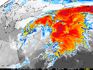
| In North America, cold
winter temperatures across the Great Lakes resulted in an unusually
high ice concentration. More than 90 percent of lakes Superior,
Erie and Huron were frozen by March 10, which is the most ice cover
on the Great Lakes since February 1994 (Duluth News Tribune). |

larger image |
 Click for larger AVI Loop (5.0MB) Click for larger AVI Loop (5.0MB) |
Colorado's biggest
winter storm of the season dumped several feet of snow on the Front
Range of the Rocky Mountains during March 17-19. Snowfall was
heaviest in Gilpin county, located west of Denver, where up to 222
cm (87.5 inches) of snow fell. |
| The Denver
International Airport was closed on the 19th, and the main terminal
was temporarily evacuated due to the possibility of a roof collapse
from the weight of heavy snow (TheDenverChannel.com). This (80.8 cm
or 31.8 inches) was Denver's second biggest snowstorm ever
recorded, and resulted in the snowiest March on record for the
city. (The most snow ever recorded in a single Denver snowstorm was
116 cm or 45.7 inches measured during the blizzard of December 1-6
of 1913.) Preliminary damage estimates from the storm were near $34
million (Associated Press). |

larger image |
References:
Basist, A., N.C. Grody, T.C. Peterson and C.N. Williams, 1998:
Using the Special Sensor Microwave/Imager to Monitor Land Surface
Temperatures, Wetness, and Snow Cover. Journal of Applied
Meteorology, 37, 888-911.
Peterson, Thomas C. and Russell S. Vose, 1997: An overview of
the Global Historical Climatology Network temperature data base.
Bulletin of the American Meteorological Society,
78, 2837-2849.
|

 Wind, Rain and Sandstorm Affect the Middle
East
Wind, Rain and Sandstorm Affect the Middle
East


 larger
image
larger
image
 larger
image
larger
image

 larger image
 larger image
 larger image
 larger image

