Global Focus
 Hurricane Kenna Strikes Mexico Hurricane Kenna Strikes Mexico |
|
Drought
| Severe to exceptional drought continued throughout much of the western United States. Above average rainfall in the eastern U.S. during September and October allowed for significant alleviation of short-term dryness. |  larger image |
Detailed drought information for the United States is available in the U.S. Drought pages.
 larger image |
In Australia, drought affected over 90 percent of New South Wales and threatened to move the country into an economic recession (Sydney Morning Herald). In the rural sector, about 40,000 jobs have been lost due to drought over the past three months, according to the Australian Bureau of Statistics. The Australian Bureau of Agriculture and Resource Economics predicted a 16 percent drop in the gross value of farm production throughout the country. |
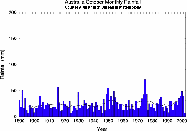
Averaged across the country, it was the driest October since 1890 in Australia, with New South Wales, Queensland and South Australia the worst affected (Australian Bureau of Meteorology).
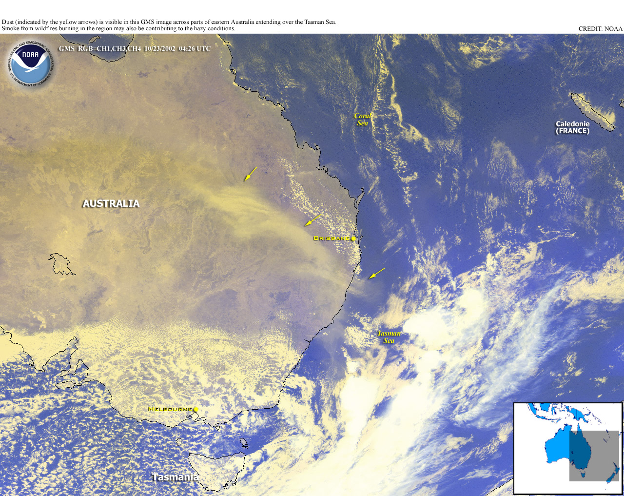
| Numerous wildfires occurred near Sydney, Australia as up to 70 fires that burned along the eastern coast of New South Wales were aggravated by warm, dry weather. As least 10 homes were destroyed by the flames (CIP report). |  larger image |
 larger image |
A large dust storm affected parts of New South Wales and Queensland during October 23-24, severely reducing visibility. |
| Temperatures over drought plagued regions of Australia were much above normal during the 18-24th, as high temperatures at Longreach in central Queensland topped out at 43.3°C (110°F) on the 20th (local time). Normal high temperatures in central Queensland in October are around 34°C (93°F). | 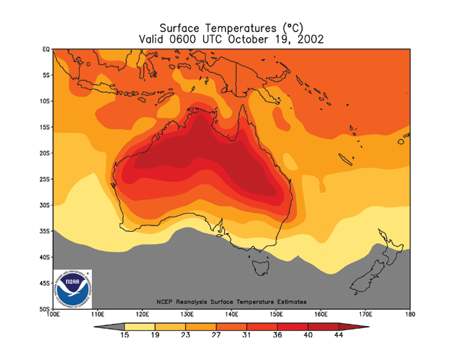 larger image |
 larger image |
Drought is affecting much of the Horn of Africa, with nearly 6 million people in Ethiopia in need of food aid (WFP). In neighboring Eritrea, prolonged drought has seriously affected agricultural and livestock production this year, threatening the lives of more than a million people (WFP/FAO). |
| In Paraguay, a 2-year drought is affecting Chaco region which includes the Department of Boqueron. The government of Paraguay declared a national emergency, as food and water reserves were depleted and approximately 5,000 people have been affected by food and water shortages. | 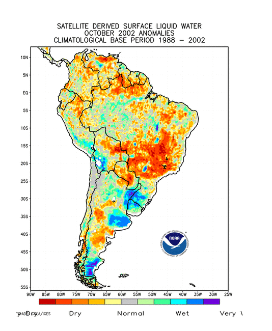 larger image |
Heavy Rainfall and Flooding
 larger image |
Torrential rain brought flash flooding to central Bangkok, Thailand on October 7, flooding homes and closing many schools. Rainfall amounts during the early morning ranged from 80-170 mm (3-7 inches) in parts of the city, up to half the normal monthly amount in October. Flooding from monsoon rains that began in early August have claimed over 120 lives in Thailand, and economists fear that flood damage could shave up to one percentage point off the forecast 2002 Gross Domestic Product (Reuters). |
Flooding continued in early October across Vietnam's Mekong Delta provinces, and was responsible for 116 deaths and over $7 million (USD) in damage since September (CIP report).
In southwestern China's Yunnan province, 15 people died after a landslide buried 14 homes in the village of Yichikou. More than 1,000 people have died in China this year due to flooding and landslides (CIP report).
In Syria, at least 25 people were killed when a landslide collapsed several houses in the city of Aleppo, located about 225 miles north of Damascus, Syria (UPI).
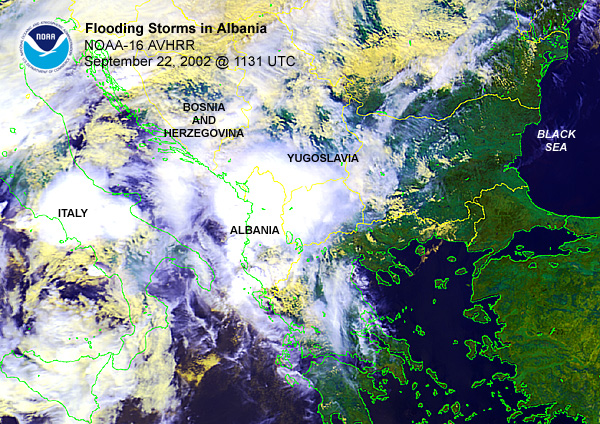
Flooding which began in late September in Albania continued into early October as a state of emergency remained in effect across 10 of the country's 12 communes.

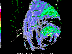
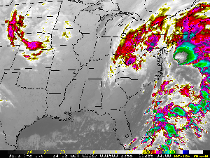
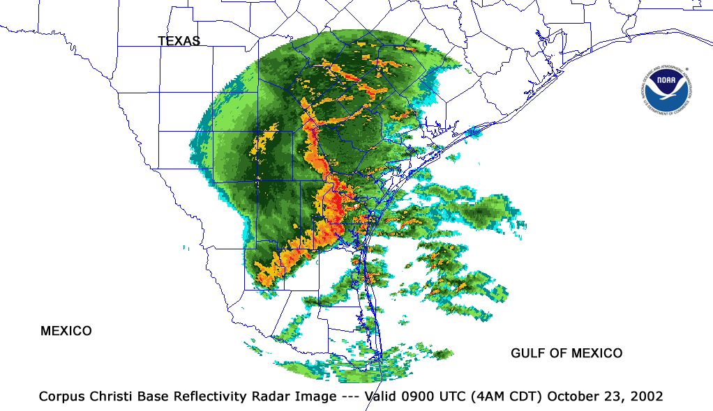
A line of thunderstorms brought severe weather to southeast Texas during the morning of October 23 (local time). Numerous reports of wind damage were received, including a wind gust to 120 km/hr (65 knots or 75 mph) at the Corpus Christi airport.
 Radar Animation Courtesy of UCAR |
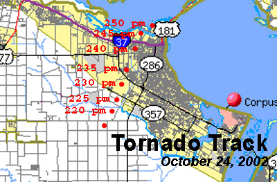
More severe weather occurred in south Texas on October 24, as thunderstorms produced tornadoes that caused one fatality and 14 injuries in the Corpus Christi area (Associated Press). Storm damage in the city was estimated as high as $100 million (USD), and Texas Governor Rick Perry declared Nueces County a disaster area. |
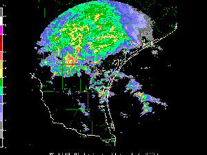
| Thunderstorms erupted along a cold front across the U.S. Plains states on October 1, resulting in numerous reports of hail and wind damage. | 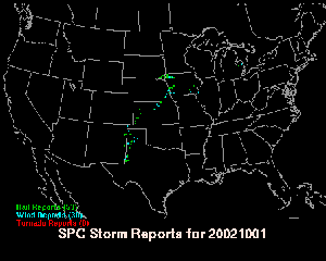 larger image |
In Israel, severe thunderstorms affected parts of the country on the 16th, with flooding reported in Haifa. Large hail from the storms damaged cars and other property (CIP report).
Tropical Cyclones
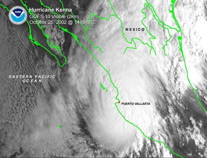
 larger image |
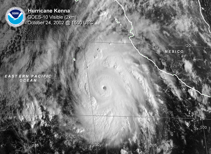
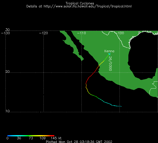
Hurricane Kenna developed in the eastern Pacific Ocean on the 21st and strengthened to a hurricane by the 23rd. On the 24th, Kenna reached category 5 intensity as maximum sustained winds reached 270 km/hr (140 knots or 165 mph). Kenna weakened slightly before making landfall on the 25th near San Blas, Mexico which is about 130 km (80 miles) north of Puerto Vallarta. Kenna resulted in three deaths, thousands of homeless and tens of millions of dollars (US) in damage (New York Times). In San Blas, only 5 percent of the town's homes remained intact after the storm. Kenna dissipated over the mountainous area of northern Mexico, producing torrential rainfall. |
 larger image |
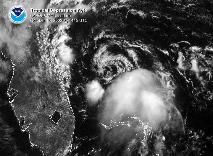
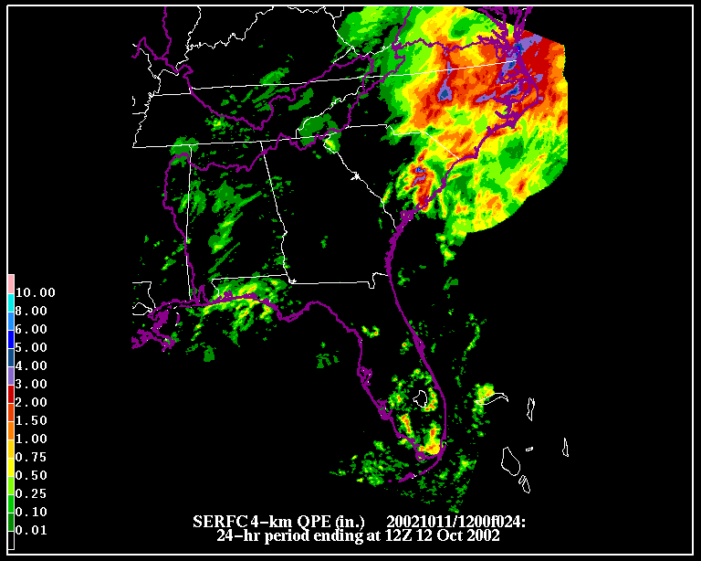
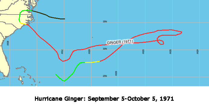
Tropical Storm Kyle developed on September 20, reaching maximum intensity as a hurricane during September 25-28. Kyle made landfall as a tropical storm on the South Carolina coast near Charleston on October 11, hugging the coast before turning back out to sea and losing its tropical characteristics. The storm brought heavy rains to coastal and inland sections of the Carolinas during the 11th and the 12th. Kyle was in the tropical Atlantic Ocean for over 3 weeks, which ranks as the third longest-lived tropical or subtropical cyclone ever in the Atlantic Ocean. The longest-lived tropical system was Hurricane Ginger, which existed for over 27 days in September and October 1971. |
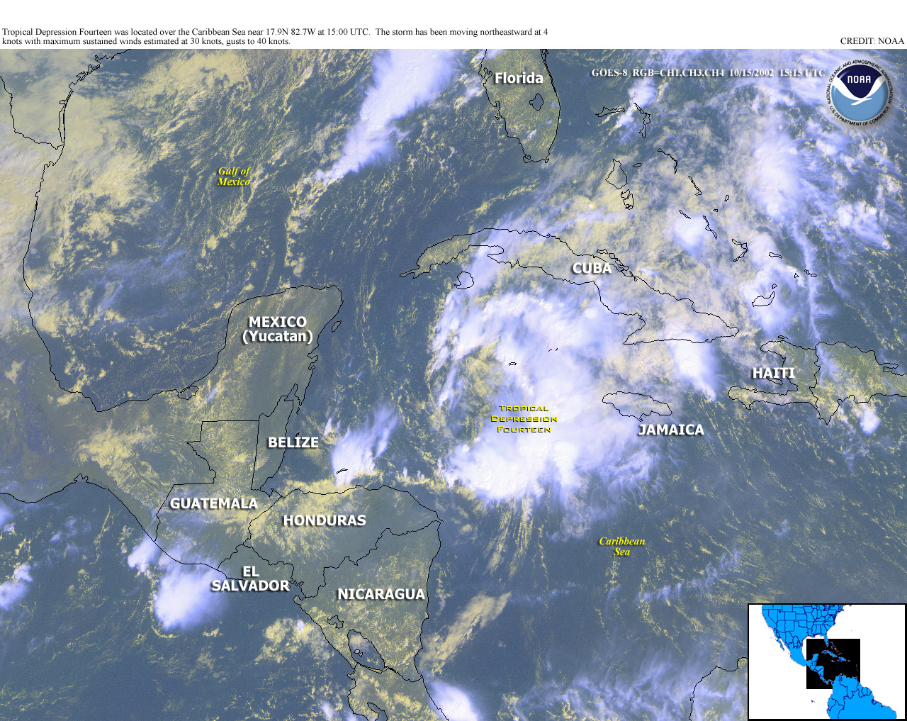
Tropical Depression #14 developed in the northwest Caribbean Sea on the 14th, about 240 km (150 miles) southwest of Grand Cayman Island. The depression moved into central Cuba on the 16th before merging with a cold front and dissipating later the same day.
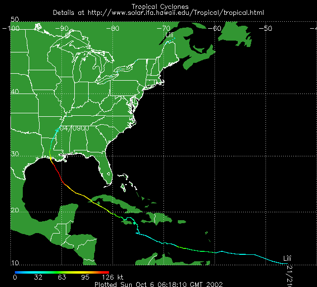
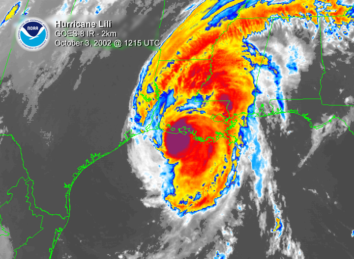
| Hurricane Lili developed as a tropical depression in the central Atlantic Ocean on September 21st and became a tropical storm two days later. Lili brought heavy rains and gusty winds over 110 km/hr (~60 knots or 70 mph) to the southern Windward Islands on September 23rd before briefly losing its identity on the 26th. The storm regained intensity and skirted the north coast of Jamaica on the 29th. Lili reached hurricane strength on the 30th, passing near the Cayman Islands and crossing western Cuba on October 1. Lili was the second hurricane in less than 2 weeks to strike western Cuba, and it forced the evacuation of thousands of people. | 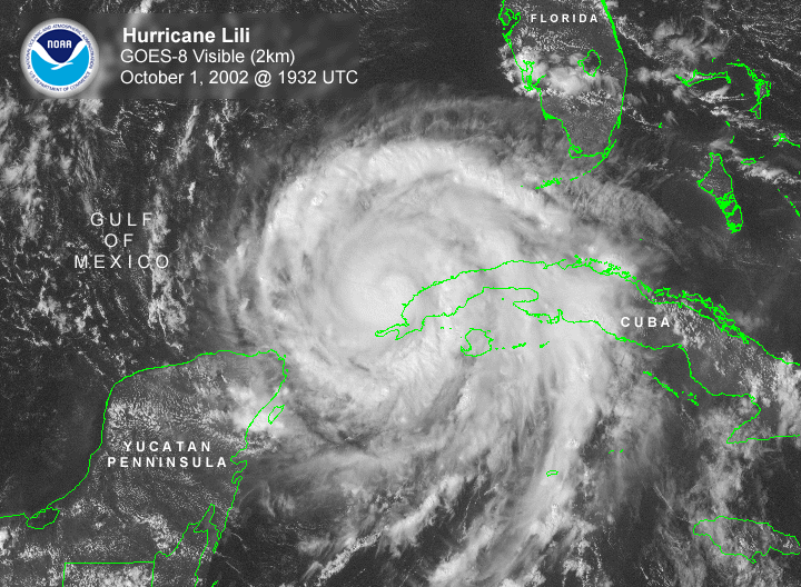 larger image |
 Radar Animation Courtesy of UCAR |
Lili pulled away from
the western tip of Cuba and strengthened into a major category 4
hurricane on October 2, reaching maximum sustained winds of 145
mph in the central Gulf of Mexico. As Lili passed just west of
a moored meteorological buoy, a wind gust to 240 km/hr (130
knots or 149 mph) was recorded, along with wave heights of 10
meters (33 feet). This is the strongest wind speed ever recorded by
a U.S. sponsored buoy.
Lili weakened prior to landfall along the central coast of Louisiana in Vermillion Bay early on October 3rd. Maximum sustained winds were near 160 km/hr (~85 knots or 100 mph), or category 2 intensity, as the storm crossed into Vermillion Parish. The storm prompted the evacuation of nearly a half-million people as it approached the Louisiana coast (Washington Post). Lili was the first landfalling U.S. hurricane since Irene in October 1999, and the preliminary damage estimate to insured property was $170 million (USD) in Louisiana.
For the latest official advisories and information on tropical systems in the western Pacific, please refer to the Joint Typhoon Warning Center. In the central Pacific, the latest information can be obtained from the Central Pacific Hurricane Forecast Center, while the latest advisories on Atlantic and eastern Pacific systems are available from the National Hurricane Center. Extratropical Cyclones
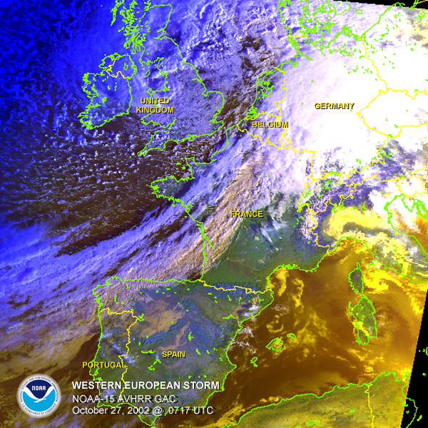
In the United Kingdom, wind gusts between 95 and 130 km/hr (60 and 80 mph) were common with a gust of 155 km/hr (96 mph) reported at Mumbles. In terms of wind speed, it was the biggest storm in the United Kingdom since late October 2000 when the Isle of Wight recorded 160 km/hr (100 mph) winds (UK Met Office).
|
