Global Temperatures
The State of the Climate November 2015 report noted that in order for 2015 to not become the warmest year in the 136-year period of record, the December global temperature would have to be at least 0.81°C (1.46°F) below the 20th century average—or 0.24°C (0.43°F) colder than the current record low December temperature of 1916. In fact, December 2015 was the warmest month of any month in the period of record, at 1.11°C (2.00°F) higher than the monthly average, breaking the previous all-time record set just two months ago in October 2015 by 0.12°C (0.21°F). This is the first time in the NOAA record that a monthly temperature departure from average exceeded 1°C or reached 2°F and the second widest margin by which an all-time monthly global temperature record has been broken. (February 1998 broke the previous record of March 1990 by 0.13°C / 0.23°F.)
With the contribution of such record warmth at year's end and with 10 months of the year record warm for their respective months, including the last 8 (January was second warmest for January and April was third warmest), the average global temperature across land and ocean surface areas for 2015 was 0.90°C (1.62°F) above the 20th century average of 13.9°C (57.0°F), beating the previous record warmth of 2014 by 0.16°C (0.29°F). This is not only the highest calendar year temperature, but also the highest temperature for any 12-month period on record. The global temperatures in 2015 were strongly influenced by strong El Niño conditions that developed during the year.
The 2015 temperature also marks the largest margin by which an annual temperature record has been broken. Prior to this year, the largest margin occurred in 1998, when the annual temperature surpassed the record set in 1997 by 0.12°C (0.22°F). Incidentally, 1997 and 1998 were the last years in which a similarly strong El Niño was occurring. The annual temperature anomalies for 1997 and 1998 were 0.51°C (0.92°F) and 0.63°C (1.13°F), respectively, above the 20th century average, both well below the 2015 temperature departure.
This marks the fourth time in the 21st century a new record high annual temperature has been set (along with 2005, 2010, and 2014) and also marks the 39th consecutive year (since 1977) that the annual temperature has been above the 20th century average. To date, including 2015, 15 of the 16 warmest years on record have occurred during the 21st century. 1998 is currently tied with 2009 as the sixth warmest year on record.
Overall, the global annual temperature has increased at an average rate of 0.07°C (0.13°F) per decade since 1880 and at an average rate of 0.17°C (0.31°F) per decade since 1970.
Sixteen Warmest Years (1880–2015)
The following table lists the global combined land and ocean annually-averaged temperature rank and anomaly for each of the 16 (two tied at #15) warmest years on record.
| Rank 1 = Warmest Period of Record: 1880–2015 |
Year | Anomaly °C | Anomaly °F |
|---|---|---|---|
| 1 | 2015 | 0.90 | 1.62 |
| 2 | 2014 | 0.74 | 1.33 |
| 3 | 2010 | 0.70 | 1.26 |
| 4 | 2013 | 0.66 | 1.19 |
| 5 | 2005 | 0.65 | 1.17 |
| 6 (tie) | 1998 | 0.63 | 1.13 |
| 6 (tie) | 2009 | 0.63 | 1.13 |
| 8 | 2012 | 0.62 | 1.12 |
| 9 (tie) | 2003 | 0.61 | 1.10 |
| 9 (tie) | 2006 | 0.61 | 1.10 |
| 9 (tie) | 2007 | 0.61 | 1.10 |
| 12 | 2002 | 0.60 | 1.08 |
| 13 (tie) | 2004 | 0.57 | 1.03 |
| 13 (tie) | 2011 | 0.57 | 1.03 |
| 15 (tie) | 2001 | 0.54 | 0.97 |
| 15 (tie) | 2008 | 0.54 | 0.97 |
Much of the record warmth for the globe can be attributed to record warmth in the global oceans. The annually-averaged temperature for ocean surfaces around the world was 0.74°C (1.33°F) higher than the 20th century average, easily breaking the previous record of 2014 by 0.11°C (0.20°F). Ocean temperatures for the year started with the first three months each third warmest for their respective months, followed by record high monthly temperatures for the remainder of the year as one of the stongest El Niños in the historical record evolved.
Prior to 2015, the highest monthly anomaly on record for the global oceans was 0.74°C (1.33°F) above the 20th century average, occurring just last year in September 2014. This all-time monthly record was broken in August 2015 (+0.78°C / +1.40°F), then broken again in September (+0.83°C / +1.49°F), and then broken once more in October (0.86°C / 1.55°F)—making three all-time new monthly high global ocean temperature records set in a single calendar year. [Three all-time records (at the time) were also broken in 2014.] In 2015, the last four months of the year were more than 0.80°C higher than their respective average, the first instances in which this monthly-average threshold has been crossed.
The warmth was due to the near-record strong El Niño that developed during the Northern Hemisphere spring in the eastern and central equatorial Pacific Ocean and to large regions of record warm and much warmer-than-average sea surface temperatures in parts of every major ocean basin. Record warmth for the year was particularly notable in large parts of the northeastern and equatorial Pacific, a large swath of the western North Atlantic, most of the Indian Ocean where a positive Indian Ocean dipole prevailed, and parts of the Arctic Ocean. Similar to 2014, some of the Southern Ocean waters off the tip of South America and part of the Atlantic Ocean south of Greenland were much cooler than average, with one localized area in the Atlantic region record cold.
Separately, temperatures were record warm across land surfaces as well. The global land temperature for 2015 was 1.33°C (2.39°F) above the 20th century average, surpassing the previous records of 2007 and 2010 by 0.25°C (0.45°F). This is the largest margin by which an annual global land surface temperature has been broken. Previously, 1981 had broken the record of 1980 by 0.22°C (0.40°F).
Because land surfaces generally have low heat capacity relative to oceans, temperature anomalies can vary greatly between months. In 2015, the average monthly land temperature anomaly ranged from +0.94°C (+1.69°F) in June to +1.89°C (+3.40°F) in December, a difference of 0.95°C (1.71°F). The ocean has a much higher heat capacity than land and thus anomalies tend to vary less over monthly timescales. During the year, the global monthly ocean temperature anomaly ranged from +0.58°C (+1.04°F; February) to +0.86°C (+1.55°F; October), a difference of 0.28°C (0.51°F).
| January–December | Anomaly | Rank (out of 136 years) | Records | ||||
|---|---|---|---|---|---|---|---|
| °C | °F | Year(s) | °C | °F | |||
| Global | |||||||
| Land | +1.33 ± 0.18 | +2.39 ± 0.32 | Warmest | 1st | 2015 | +1.33 | +2.39 |
| Coolest | 136th | 1884 | -0.61 | -1.10 | |||
| Ocean | +0.74 ± 0.01 | +1.33 ± 0.02 | Warmest | 1st | 2015 | +0.74 | +1.33 |
| Coolest | 136th | 1909 | -0.45 | -0.81 | |||
| Land and Ocean | +0.90 ± 0.08 | +1.62 ± 0.14 | Warmest | 1st | 2015 | +0.90 | +1.62 |
| Coolest | 136th | 1908 | -0.44 | -0.79 | |||
| Northern Hemisphere | |||||||
| Land | +1.44 ± 0.21 | +2.59 ± 0.38 | Warmest | 1st | 2015 | +1.44 | +2.59 |
| Coolest | 136th | 1884 | -0.70 | -1.26 | |||
| Ocean | +0.87 ± 0.01 | +1.57 ± 0.02 | Warmest | 1st | 2015 | +0.87 | +1.57 |
| Coolest | 136th | 1908, 1909 | -0.47 | -0.85 | |||
| Land and Ocean | +1.09 ± 0.11 | +1.96 ± 0.20 | Warmest | 1st | 2015 | +1.09 | +1.96 |
| Coolest | 136th | 1908 | -0.47 | -0.85 | |||
| Southern Hemisphere | |||||||
| Land | +1.04 ± 0.11 | +1.87 ± 0.20 | Warmest | 1st | 2015 | +1.04 | +1.87 |
| Coolest | 136th | 1891 | -0.59 | -1.06 | |||
| Ocean | +0.64 ± 0.02 | +1.15 ± 0.04 | Warmest | 1st | 2015 | +0.64 | +1.15 |
| Coolest | 136th | 1911 | -0.43 | -0.77 | |||
| Land and Ocean | +0.70 ± 0.06 | +1.26 ± 0.11 | Warmest | 1st | 2015 | +0.70 | +1.26 |
| Coolest | 136th | 1911 | -0.44 | -0.79 | |||
| Arctic | |||||||
| Land and Ocean | +1.53 ± 0.16 | +2.75 ± 0.29 | Warmest | 1st | 2015 | +1.53 | +2.75 |
| Coolest | 136th | 1902 | -1.23 | -2.21 | |||
The 1901-2000 average combined land and ocean annual temperature is 13.9°C (56.9°F), the annually averaged land temperature for the same period is 8.5°C (47.3°F), and the long-term annually averaged sea surface temperature is 16.1°C (60.9°F).
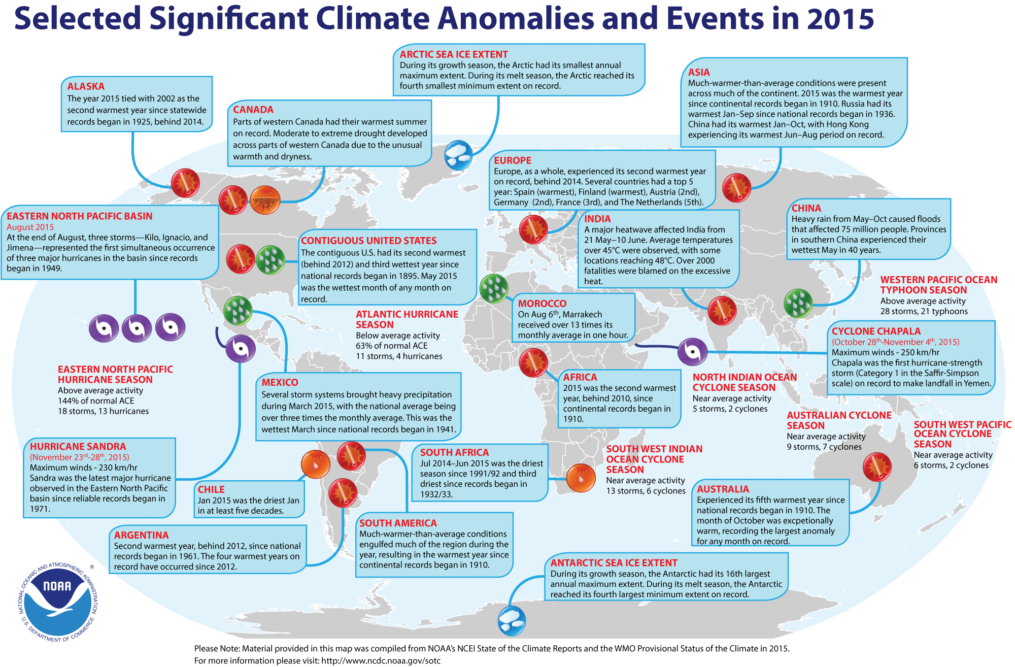
Regional Temperatures
The following information was compiled from previous NCDC monitoring reports and public reports by National Hydrometeorological Services (NHMSs; peers of the U.S. National Weather Service), including those submitted to inform the Provisional Status of the Climate in 2015 by the World Meteorological Organization. More comprehensive information will be available in the WMO's final Statement, to be released in Spring 2016.
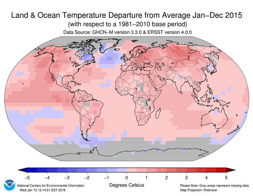
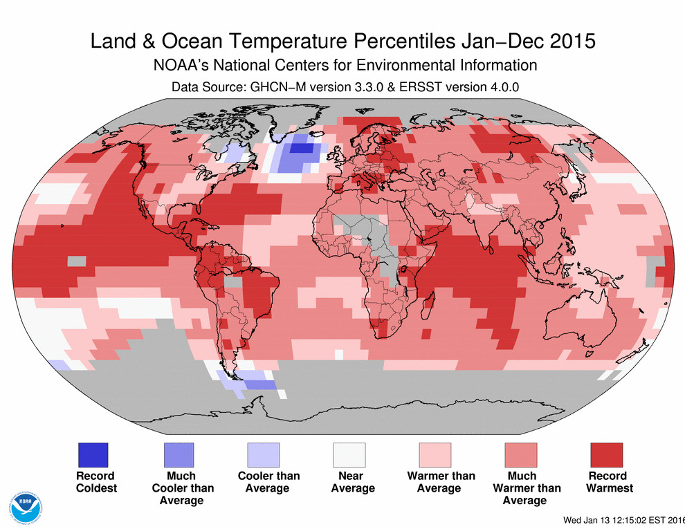
Most areas of the world experienced above-average annual temperatures, as indicated by the Temperature Percentiles map below. Record warmth was observed over various regions of the world's land surfaces, including Central America, the northern half of South America, parts of northern, southern, and eastern Europe stretching into western Asia, a large section of east central Siberia, regions of eastern and southern Africa. It was also much warmer than average across many other land areas all across the globe. Only part of Quebec in northeastern Canada and the very southern tip of Argentina were cooler than average. No land areas were record cold or even much cooler than average.
The World Meteorological Organization (WMO) reported that Europe experienced its second warmest year, behind only the record warmth of 2014. As detailed below, many countries confirmed record or near-record warmth for the year:
- Austria observed its second warmest year in its 247-year period of record, behind only 2014, with an annual temperature 1.5°C (2.7°F) above the 1981–2010 average. According to ZAMG, the overall high temperature was driven primarily by constant warmth throughout the year, with 10 months much warmer than their long-term averages, July being record warm and December second warmest. For alpine stations only, 2015 tied with 2011 and 2014 as the warmest year on record for the high elevation regions of the country.
- France observed its third warmest year since national records began in 1900, at 1.0°C (1.8°F) higher than the 1981–2010 average; only 2014 and 2011 were warmer. December 2015 saw temperatures above the average for March.
- In The Netherlands, 2015 tied as the fifth warmest year since national records began in 1706. The temperature in De Bilt was 0.8°C (1.4°F) above average. An extremely warm November and December were major contributors to the overall warmth.
- In Spain, even with a cool start to the year, 2015 tied with 2011 as the warmest year in the 51-year period of record, at 0.94°C (1.69°F) above the 1981–2010 average. The month of May and the summer season were both second warmest on record (July was record warm) and the year was capped with its second warmest December.
- Finland observed its warmest year on record during 2015. Lapland was the only province that was not record warm; it was second warmest. The average temperature for the country was 1.9°C (3.4°F) higher than the 1981–2010 average. New monthly high temperatures for the country were recorded in both November and December: 14.3°C (57.7°F) in Kemiönsaari on November 3rd and 11.3°C (52.3°F) in Pori and Kokemäki on December 20th.
- 2015 tied with 2000 and 2007 as the second warmest year in the 135-year period of record for Germany, with an annual temperature 1.7°C (3.1°F) above the 1981–2010 average. The warmest year on record is 2014. Both November and December were record warm for their respective months.
- Across the Atlantic in Iceland, preliminary data indicate that the 2015 temperature was 0.2°C (0.4°F) higher than the 1981–2010 average. This is the 20th consecutive year with an above-average temperature, but coolest among all years to-date in the 21st century.
Overall, Asia observed its warmest year on record during 2015. With national information available through November 2015 and records dating back to 1961, China began 2015 with a warm January, 1.9°C (3.4°F) above the 1981–2010 average. This was the warmest on record for the month and was followed by its sixth warmest February and fourth warmest March. All of the subsequent months through November remained above average, albeit by a smaller margin. With records dating back to 1884, Hong Kong was record warm during both June and July. With the exception of July and August, the temperature was above average throughout the year in South Korea. The highest monthly departures from average occurred at the beginning of the year (January: +1.5°C / 2.9°F) and the end of the year (December: +2.5°C / 4.5°F). In Japan, record high temperatures were observed across the eastern portion of the country in April, with the record warmth spreading to the northern regions in May as well. Okinawa/Amani was record warm during both June and November.
The African continent observed its second warmest year, behind only 2010. Northern Africa began the year colder than average, but by March temperatures became warmer than average across the region. Temperature departures remained high for the remainder of the year, with the area recording its fourth warmest summer and September, October, and November all among their 10 warmest since records began in 1980. As of this release, December data were not yet available. In South Africa, many record high temperatures were observed during the Southern Hemisphere spring. Vredendal reached 48.4°C (119.1°F) on October 27th, soaring past the previous record high temperature of October 30th, 1999 by 5.9°C (10.6°F). A heatwave during November 9th–12th brought 74 new record high maximum and 16 high minimum temperature records to stations in the northern provinces of the country.
In South America, the continent as a whole was the warmest on record for 2015. Argentina observed its second warmest year in the country's 55-year period of record, making the past four years (2012–2015) the four warmest in that record, with 2012 warmest. The cities of Iguazu, Old Willow, Rosario, Pehuajó and Buenos Aires were record warm for 2015. On average, Chile observed warmer-then-average monthly temperatures throughout most of the year. October, however, was cooler than average.
Following its warmest year on record in 2013 and third warmest in 2014, 2015 remained warm in Australia, with the country experiencing its fifth highest nationally-averaged annual temperature in the 106-year period of record, with a mean temperature 0.83°C (1.49°F) higher than the 1961–1990 average, according to the Bureau of Meteorology. The last three months of the year in particular, which included several significant heat waves, contributed to the exceptional warmth. October was record warm for the country, while April and May were actually below average for their respective months. The strong El Niño and record warmth of the Indian Ocean influenced the temperatures in this region during the year. Including 2015, 8 of the 10 warmest years in Australia have occurred since 2002. The past three springs (September–November 2013, 2014, 2015) have been the three warmest on record. Most of New Zealand saw near-average temperatures for 2015 as a whole, although above-average temperatures (0.5–1.2°C / 0.9–1.9°F) were observed in parts of the Bay of Plenty and Queenstown Lakes district. The nationally averaged annual temperature for the country was 0.1°C (0.2°F) above the 1981–2010 average.
Despite the cold start to the year in parts of eastern North America, the continent as a whole experienced its fifth warmest year on record. Record and near-record heat during much of the year in the western part of the contiguous United States and record heat in December across the eastern half contributed to the country's second warmest year on record, at 1.3°C (2.4°F) above the 20th century average. The warmest year occurred in 2012. This marks the 19th consecutive year the contiguous U.S. has observed an above-average annual temperature. Every state reported an above-average temperature for the year, with Florida, Montana, Oregon, and Washington record warm. The average temperature for Alaska during 2015 was 2.3°C (4.1°F) above average. This tied 2002 as the second warmest year on record, behind the record warmth of last year, in a record that dates back to 1925. For the winter period, western Canada observed record high temperatures along the Pacific Coast. Many regions across western Canada also had their warmest summer on record.
Global Precipitation
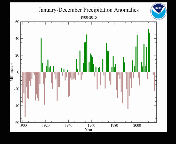
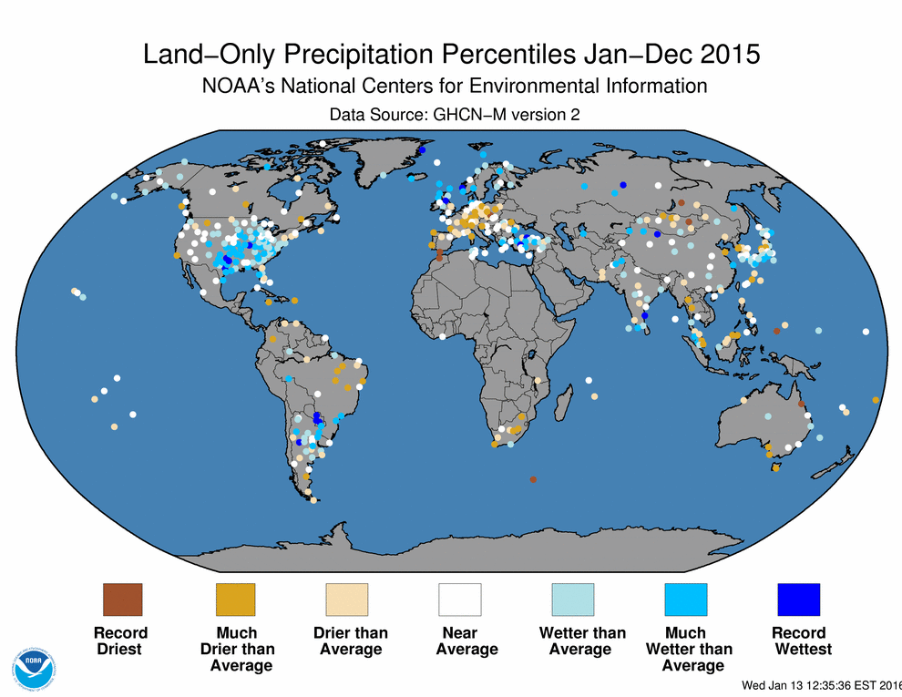
For 2015, annual precipitation was just below average on balance for land-based rain gauges around the globe. Precipitation for 2015 was 22.5 mm (0.8 inch) below the 1961–1990 average of 1,033 mm (40.7 inches). As indicated by the Global Precipitation Percentiles map below, the eastern half of the United States was notably wet, as were regions in southern South America, parts of northern and southeastern Europe, and areas of Japan. Dryness was notable in eastern Brazil, central Europe, South Africa, Mongolia, and parts of southeastern Asia. Also, as discussed below, extreme precipitation and drought events occurred across the world.
In South Africa, the season from July 2014 to June 2015 was the driest such period since 1991/92 and the third driest in a record that began in 1932/33. The dry conditions are ongoing with no significant rain having yet been received in the early part of the 2015/16 rainy season.
The end of summer in the Southern Hemisphere was a dry one for Australia, with February receiving just 49 percent of average monthly precipitation, marking the country's 11th driest February on record. The dryness encompassed most of the country, with every state and the Northern Territory reporting below-average rainfall. Later, an East Coast Low in late April brought heavy rainfall to coastal New South Wales, Australia, resulting several daily and monthly rainfall records. It was the 11th wettest April on record and wettest April in 25 years for the state.
In February, heavy rain affected countries in southern Europe including Italy and the southern Balkan Peninsula. In May, Sweden was very wet across almost the entire country, with the capital city of Stockholm observing its wettest May in 200 years. Norway had its second wettest May in its 116-year period of record. .
Guam International Airport observed just 7.8 mm of precipitation during February. This was the lowest monthly rainfall for any month at this location since records began here in 1957.
In February, heavy rain affected Morocco, Algeria and Tunisia. Alhoceima, Morocco received 206.1 mm, 574 percent of its average monthly precipitation.
In February, heavy rain in Argentina broke February precipitation records at many stations. The Córdoba Observatory recorded 385.4 mm of rain for the month, easily surpassing the 127-year standing record of 266.4 mm set in 1889.
Torrential rainfall led to major flooding events in Angola in mid-March. The Angolan capital of Luanda was impacted on March 9th while heavy rainfall and subsequent flooding hit Lobito three days later.
Some areas in Chile experienced their driest January in at least 50 years. But near the end of March, in northern Chile, unusually heavy rainfall impacted the extremely dry regions of Atacama and Antofagasta. Some areas received well over their annual rainfall during this event. Antofagasta received 24.4 mm of rainfall in 24 hours during March 25th–26th, about the average rainfall expected over a 14-year period.
At the end of March drought remained entrenched in the western United States, where mountain snowpack was record low for many locations in the Cascade and Sierra Nevada Mountains. Moderate to exceptional drought conditions were present across more than 98 percent of California, leading to unprecedented water restrictions in the state. Even with several heavy rainfall events from El Niño conditions toward the end of the year, nearly 88 percent of the state continued to experience the ongoing drought at year's end.
Mexico had its wettest March since national records began in 1941, at 373 percent of the normal precipitation. in June, Baja California and Baja California Sur each had their wettest June on record.
Heat in Spain during May was accompanied by extreme dryness. With precipitation records dating back to 1947, May 2015 was the driest May on record for the country, with total average rainfall for the month just 25 percent of normal.
Heavy rainfall brought torrential floods to the capital city of Tbilisi, Georgia as the Vere River overflowed its banks in June. At least 49 mm of rain fell on June 14th, with locally heavier amounts in places.
Mauritius, in the southwest Indian Ocean, had its wettest June since 1976, receiving 180 percent of average precipitation.
New Zealand experienced both wet and dry extremes during June. Due to heavy rains, major flooding impacted areas of the lower North Island during June 20th–21st. Whanganui experienced its worst flood on record, as more than 100 mm of rain reportedly fell within a 24-hour period. On the other hand, it was dry in the eastern parts of both the North and South Islands. Soil moisture was particulalry dry around East Cape, around Napier, coastal Wairarapa, southern Marlborough, and eastern parts of Canterbury north of Christchurch.
The Southwest Indian monsoon season lasts from June to September. In 2015, the monsoon made its annual onset over Kerala on June 5th, just a few days later than normal. Rainfall for the seasonal period June 1st to September 30th was 86 percent of the 1951–2000 average. About half of India received normal rainfall, while the other half received deficient rainfall (less than 80 percent of average). This marks the fourth time in the 115-year record that two consecutive years have been below average.
Heavy precipitation fell across parts of northeastern Argentina in August. The heavy downpours overflowed rivers and prompted floods. Many locations broke their precipitation total records for the month.
Austria recorded only 35 percent of normal precipitation in August 2015, marking its driest August since 1991.
Between May and October, China experienced 35 heavy rain events. During May 5th–31st , the Huanan region in the northeast received rainfall 150 percent of its average precipitation, the most in nearly 40 years.
Latvia had its driest October on record, at 8.7 mm of rainfall for the month, or 13 percent of the average monthly rainfall. This breaks the previous record of 9.9 mm accumulation set in 1951.
In the southwestern highlands of Tanzania 327.8 mm of rain was recorded at the Tukuyu station on November 4th, the highest recorded at the station.
Brazil, which started the year in drought in southern and eastern areas, saw the focus of the drought shift northward with little rainfall during the dry season over the Amazon. The drought continued through the year, impacting major cities including Rio de Janeiro and São Paulo.
Large areas of Puerto Rico, Central America, and the Caribbean recorded below average rainfall for the year. This dryness is typical during El Niño events.
With an average total of 904 mm, preliminary data indicate that Denmark fell just 1 mm shy of tying 1999 for the wettest year since national records began in 1874. This is despite observing its driest October since 1972, with just 29 mm of rainfall, or about 30 percent of average for the month. November–December marked the wettest two-month period since August–September 1994 and the third wettest such period in measurement history.
The United Kingdom observed 1289 mm of total rainfall on average during 2015, marking its sixth wettest year in the 116-year period of record. From late autumn through the end of 2015, a series of storms brought extremely wet conditions and flooding to the northern and western regions of the UK. On December 5th, Storm Desmond dropped 341 mm of rainfall over Honister Pass, Cambria, setting an all-time 24-hour record for the UK.
In contrast, France received less than 90 percent of its average precipitation total for 2015, making this one of the 10 driest years for the country in the past half century.
References
- Peterson, T.C. and R.S. Vose, 1997: An Overview of the Global Historical Climatology Network Database. Bull. Amer. Meteorol. Soc., 78, 2837-2849.
- Quayle, R.G., T.C. Peterson, A.N. Basist, and C. S. Godfrey, 1999: An operational near-real-time global temperature index. Geophys. Res. Lett., 26, 333-335.
- Smith, T.M., and R.W. Reynolds (2005), A global merged land air and sea surface temperature reconstruction based on historical observations (1880-1997), J. Clim., 18, 2021-2036.
- Smith, et al (2008), Improvements to NOAA's Historical Merged Land-Ocean Surface Temperature Analysis (1880-2006), J. Climate., 21, 2283-2293.