Note: With this report and data release, the National Centers for Environmental Information is transitioning to improved versions of its global land (GHCN-M version 3.3.0) and ocean (ERSST version 4.0.0) datasets. Please note that anomalies and ranks reflect the historical record according to these updated versions. Historical months and years may differ from what was reported in previous reports. For more, please visit the associated FAQ and supplemental information.
Introduction
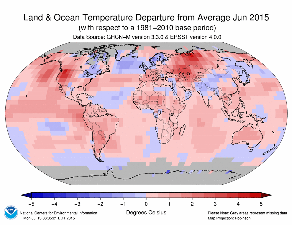
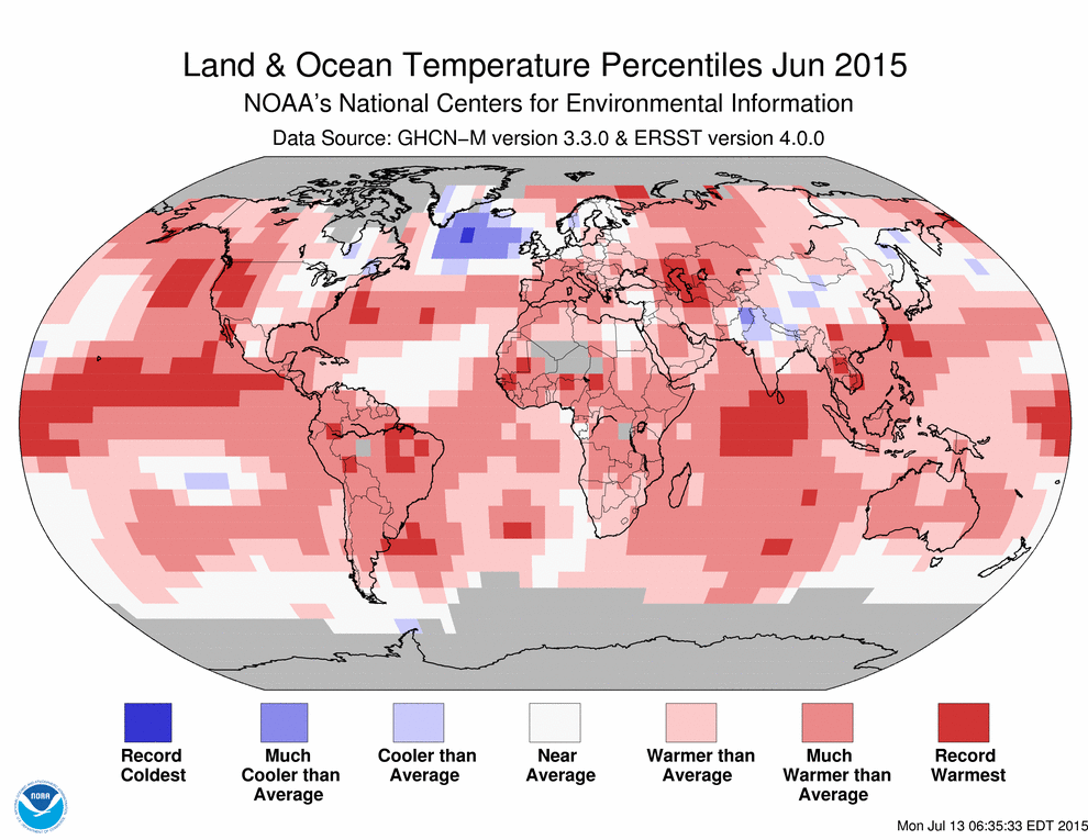
Temperature anomalies and percentiles are shown on the gridded maps below. The anomaly map on the left is a product of a merged land surface temperature (Global Historical Climatology Network, GHCN) and sea surface temperature (ERSST.v4) anomaly analysis as described in Huang et al. (2015). Temperature anomalies for land and ocean are analyzed separately and then merged to form the global analysis. For more information, please visit NCDC's Global Surface Temperature Anomalies page. The percentile map on the right provides additional information by placing the temperature anomaly observed for a specific place and time period into historical perspective, showing how the most current month, season or year compares with the past.
The most current data may be accessed via the Global Surface Temperature Anomalies page.
Temperatures
In the atmosphere, 500-millibar height pressure anomalies correlate well with temperatures at the Earth's surface. The average position of the upper-level ridges of high pressure and troughs of low pressure—depicted by positive and negative 500-millibar height anomalies on the  June 2015 and
  April–June 2015 maps—is generally reflected by areas of positive and negative temperature anomalies at the surface, respectively.
June
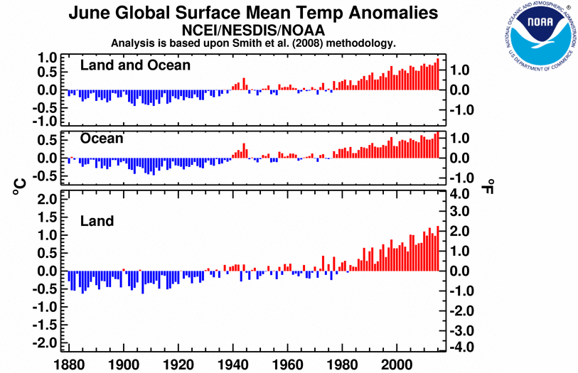
The combined average temperature over global land and ocean surfaces for June 2015 was the highest for June in the 136-year period of record, at 0.88°C (1.58°F) above the 20th century average of 15.5°C (59.9°F), surpassing the previous record set just one year ago by 0.12°C (0.22°F). This was also the fourth highest monthly departure from average for any month on record. The two highest monthly departures from average occurred earlier this year in February and March, both at 0.90°C (1.62°F) above the 20th century average for their respective months, while January 2007 had the third highest, at 0.89°C (1.60°F) above its monthly average.
June 2015 also marks the fourth month this year that has broken its monthly temperature record, along with February, March, and May. The other months of 2015 were not far behind: January was second warmest for its respective month and April was third warmest. These six warm months combined with the previous six months (four of which were also record warm) to make the period July 2014–June 2015 the warmest 12-month period in the 136-year period of record, surpassing the previous record set just last month (June 2014–May 2015). As shown in the table below, the 10 warmest 12-month periods have all been marked in the past 10 months.
| Rank 1 = Warmest Period of Record: 1880–2015 |
12-month Period | Anomaly °C | Anomaly °F |
|---|---|---|---|
| 1 | July 2014–June 2015 | 0.83 | 1.49 |
| 2 | June 2014–May 2015 | 0.82 | 1.48 |
| 3 | May 2014–April 2015 | 0.81 | 1.46 |
| 4 | April 2014–March 2015 | 0.80 | 1.44 |
| 5 | March 2014–February 2015 | 0.79 | 1.42 |
| 6 (tie) | January–December 2014 | 0.78 | 1.40 |
| 6 (tie) | February 2014–January 2015 | 0.78 | 1.40 |
| 8 | December 2013–November 2014 | 0.77 | 1.39 |
| 9 | November 2013–October 2014 | 0.74 | 1.33 |
| 10 (tie*) | October 2013–September 2014 | 0.73 | 1.31 |
*ties with four other 12-month periods.
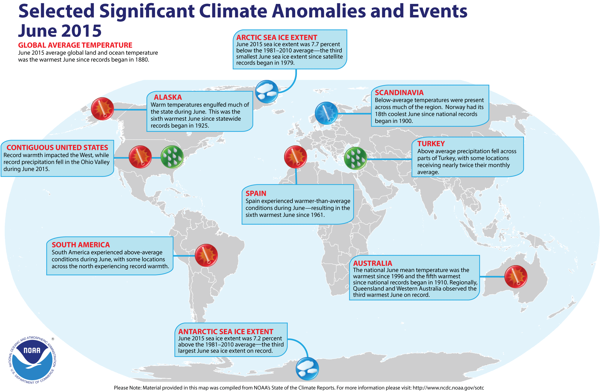
The average global temperature across land surfaces was 1.26°C (2.27°F) above the 20th century average of 13.3°C (55.9°F), the highest June temperature over land on record, surpassing the previous record set in 2012 by 0.06°C (0.11°F). Large regions of Earth's land surfaces were much warmer than average, according to the Land & Ocean Temperature Percentiles map above, with record warmth across the western United States, parts of northern South America, several regions in central to western Africa, central Asia around and to the east of the Caspian Sea, and parts of southeastern Asia. Western Greenland and some areas in India and China were cooler than average, and northern Pakistan was much cooler than average..
Select national information is highlighted below. (Please note that different countries report anomalies with respect to different base periods. The information provided here is based directly upon these data):
- The first month of winter in Australia was the fifth warmest June in the country's 106-year period of record, with a temperature that was 1.35°C (2.43°F) higher than the 1961–1990 average. Much of the warmth was driven by daily maximum temperatures, which were the sixth highest on record when averaged across the country. Western Australia experienced its highest maximum June temperature on record, at 2.23°C (4.01°F), smashing the previous record of 1962 by 0.48°C (0.86°F). Many locations in Western Australia had their warmest June overall, according to the Bureau of Meteorology.
- Scandinavia represented one of the few cold spots around the world in June. Norway reported its 18th coolest June since records began in 1900, at 1.7°C (3.1°F) below the 1961–1990 average. According to the Finnish Meteorological Institute, most of Finland experienced temperatures 1–2°C (2–4°F) below the 1981–2010 average.
- Spain experienced a June temperature that was 1.4°C (2.5°F) above the 1981–2010 national average. This marks the sixth warmest June for the country since records began in 1961. The six highest June temperatures have all occurred since 2003.
- It was also warm in Austria during June, at 1.4°C (2.5°F) higher than the 1981–2010 average. This marked the 10th warmest June for the country in the 249-year period of record.
- Overall, temperatures were near-average across New Zealand during June at 0.4°C (0.7°F) above the 1981–2010 average. However, a polar outbreak at the end of the month affected the entire country, but was particularly notable in Canterbury and Otago. Parts of inland Canterbury had the coldest temperatues recorded anywhere in New Zealand in the past two decades. The lowest temperature of -21.0°C (-5.8°F) recorded at Tara Hills in the Mackenzie Country on June 24th was the fourth lowest temperature ever recorded in New Zealand.
For the oceans, the June global sea surface temperature was 0.74°C (1.33°F) above the 20th century average of 16.4°C (61.5°F), the highest for June on record, surpassing the previous record set last year by 0.06°C (0.11°F). This also tied with September 2014 as the highest monthly departure from average for any month for the globally-averaged sea surface temperature. Nine of the ten highest monthly departures from average have occurred since May 2014.
Moderate El Niño conditions were present across the central and eastern equatorial Pacific Ocean during the month. According to NOAA's Climate Prediction Center, there is a greater than 90 percent chance that El Niño will continue through Northern Hemisphere winter 2015/16, and around an 80 percent chance it will last into early spring 2016. The current atmospheric and oceanic features reflect an ongoing and strengthening El Niño. This forecast focuses on the ocean surface temperatures between 5°N and 5°S latitude and 170°W to 120°W longitude, called the Niño 3.4 region.
Notably during June, record warmth was observed across much of the northeastern and equatorial Pacific as well as parts of the equatorial and southern Indian Ocean, various regions of both the North and South Atlantic Ocean, and the Barents Sea to the northeast of Scandinavia. Only part of the North Atlantic between Greenland and the United Kingdom was much cooler than average, an area that had been record cold for several months in 2015.
| June | Anomaly | Rank (out of 136 years) | Records | ||||
|---|---|---|---|---|---|---|---|
| °C | °F | Year(s) | °C | °F | |||
| Global | |||||||
| Land | +1.26 ± 0.13 | +2.27 ± 0.23 | Warmest | 1st | 2015 | +1.26 | +2.27 |
| Coolest | 136th | 1885, 1907 | -0.63 | -1.13 | |||
| Ocean | +0.74 ± 0.03 | +1.33 ± 0.05 | Warmest | 1st | 2015 | +0.74 | +1.33 |
| Coolest | 136th | 1911 | -0.48 | -0.86 | |||
| Land and Ocean | +0.88 ± 0.08 | +1.58 ± 0.14 | Warmest | 1st | 2015 | +0.88 | +1.58 |
| Coolest | 136th | 1904, 1911 | -0.44 | -0.79 | |||
| Northern Hemisphere | |||||||
| Land | +1.26 ± 0.13 | +2.27 ± 0.23 | Warmest | 2nd | 2012 | +1.42 | +2.56 |
| Coolest | 135th | 1907 | -0.69 | -1.24 | |||
| Ocean | +0.87 ± 0.03 | +1.57 ± 0.05 | Warmest | 1st | 2015 | +0.87 | +1.57 |
| Coolest | 136th | 1913 | -0.53 | -0.95 | |||
| Land and Ocean | +1.02 ± 0.11 | +1.84 ± 0.20 | Warmest | 1st | 2015 | +1.02 | +1.84 |
| Coolest | 136th | 1913 | -0.53 | -0.95 | |||
| Southern Hemisphere | |||||||
| Land | +1.26 ± 0.17 | +2.27 ± 0.31 | Warmest | 1st | 2015 | +1.26 | +2.27 |
| Coolest | 136th | 1911 | -0.98 | -1.76 | |||
| Ocean | +0.64 ± 0.04 | +1.15 ± 0.07 | Warmest | 1st | 2015 | +0.64 | +1.15 |
| Coolest | 136th | 1911 | -0.53 | -0.95 | |||
| Land and Ocean | +0.74 ± 0.06 | +1.33 ± 0.11 | Warmest | 1st | 2015 | +0.74 | +1.33 |
| Coolest | 136th | 1911 | -0.60 | -1.08 | |||
| Arctic | |||||||
| Land and Ocean | +1.29 ± 0.18 | +2.32 ± 0.32 | Warmest | 5th | 2012 | +1.69 | +3.04 |
| Coolest | 132nd | 1885 | -1.34 | -2.41 | |||

The most current data June be accessed via the Global Surface Temperature Anomalies page.
Year-to-date (January–June)
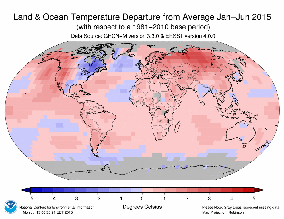

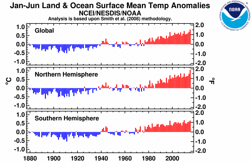
The first six months of 2015 comprised the warmest such period on record across the world's land and ocean surfaces, at 0.85°C (1.53°F) above the 20th century average, surpassing the previous record set in 2010 by 0.09°C (0.16°F). It should be noted that 2010 was the last year with El Niño conditions; however El Niño had ended by this point in 2010, while it appears to be continuing to mature at the same point in 2015.
The average global sea surface temperature of +0.65°C (+1.17°F) for the year-to-date was the highest for January–June in the 136-year period of record, surpassing the previous record of 2010 by 0.04°C (0.07°F). The average land surface temperature of +1.40°C (2.52°F) was also record high, surpassing the previous record of 2007 by 0.13°C (0.23°F).
Most of the world's land areas were much warmer than averge, that is falling within the top 10 percent of their historical temperature range for the January–June period, as in dicated by the Temperature Percentiles map above. These regions include nearly all of Eurasia, South America, Africa, and western North America, with pockets of record warmth across these areas. All of Australia was warmer than average. The oceans were also much warmer than average across vast expanses, with much of the northeastern and equatorial Pacific, large parts of the western North Atlantic, and the Barents Sea notably record warm. Over land, only northeastern Canada was much cooler than average during the first half of 2015, as was the North Atlantic Ocean to the south of Greenland, with a region of observed record cold.
| January–June | Anomaly | Rank (out of 136 years) | Records | ||||
|---|---|---|---|---|---|---|---|
| °C | °F | Year(s) | °C | °F | |||
| Global | |||||||
| Land | +1.40 ± 0.20 | +2.52 ± 0.36 | Warmest | 1st | 2015 | +1.40 | +2.52 |
| Coolest | 136th | 1893 | -0.87 | -1.57 | |||
| Ocean | +0.65 ± 0.03 | +1.17 ± 0.05 | Warmest | 1st | 2015 | +0.65 | +1.17 |
| Coolest | 136th | 1911 | -0.50 | -0.90 | |||
| Land and Ocean | +0.85 ± 0.09 | +1.53 ± 0.16 | Warmest | 1st | 2015 | +0.85 | +1.53 |
| Coolest | 136th | 1911 | -0.51 | -0.92 | |||
| Northern Hemisphere | |||||||
| Land | +1.57 ± 0.24 | +2.83 ± 0.43 | Warmest | 1st | 2015 | +1.57 | +2.83 |
| Coolest | 136th | 1893 | -0.99 | -1.78 | |||
| Ocean | +0.74 ± 0.04 | +1.33 ± 0.07 | Warmest | 1st | 2015 | +0.74 | +1.33 |
| Coolest | 136th | 1904, 1911 | -0.46 | -0.83 | |||
| Land and Ocean | +1.05 ± 0.13 | +1.89 ± 0.23 | Warmest | 1st | 2015 | +1.05 | +1.89 |
| Coolest | 136th | 1893 | -0.61 | -1.10 | |||
| Southern Hemisphere | |||||||
| Land | +0.97 ± 0.17 | +1.75 ± 0.31 | Warmest | 3rd | 2005, 2010 | +1.07 | +1.93 |
| Coolest | 134th | 1917 | -0.83 | -1.49 | |||
| Ties: 1998, 2013 | |||||||
| Ocean | +0.60 ± 0.04 | +1.08 ± 0.07 | Warmest | 2nd | 2010 | +0.61 | +1.10 |
| Coolest | 135th | 1911 | -0.53 | -0.95 | |||
| Land and Ocean | +0.66 ± 0.07 | +1.19 ± 0.13 | Warmest | 2nd | 2010 | +0.68 | +1.22 |
| Coolest | 135th | 1911 | -0.55 | -0.99 | |||
| Arctic | |||||||
| Land and Ocean | +2.03 ± 0.25 | +3.65 ± 0.45 | Warmest | 1st | 2015 | +2.03 | +3.65 |
| Coolest | 136th | 1966 | -1.48 | -2.66 | |||

The most current data June be accessed via the Global Surface Temperature Anomalies page.
Precipitation
June
The maps below represent precipitation percent of normal (left, using a base period of 1961–1990) and precipitation percentiles (right, using the period of record) based on the GHCN dataset of land surface stations. As is typical, precipitation anomalies during June 2015 varied significantly around the world.
Select national information is highlighted below. (Please note that different countries report anomalies with respect to different base periods. The information provided here is based directly upon these data):
- Heavy rainfall brought torrential floods to the captial city of Tbilisi, Georgia as the Vere River overflowed its banks. At least 49 mm of rain fell on June 14, with locally heavier amounts in places. At least 19 people were killed due to the floods and the local zoo was destroyed, with animals freely roaming streets in the city.
- New Zealand experienced both wet and dry extremes during June. Due to heavy rains, major flooding impacted areas of the lower North Island during June 20th–21st. Whanganui experienced its worst flood on record, as more than 100 mm reportedly fell within a 24-hour period. On the other hand, it was dry in the eastern parts of both the North and South Islands. Soil moisture was particulalry dry around East Cape, around Napier, coastal Wairarapa, southern Marlborough, and eastern parts of Canterbury north of Christchurch.


References
- Peterson, T.C. and R.S. Vose, 1997: An Overview of the Global Historical Climatology Network Database. Bull. Amer. Meteorol. Soc., 78, 2837-2849.
- Huang, B., V.F. Banzon, E. Freeman, J. Lawrimore, W. Liu, T.C. Peterson, T.M. Smith, P.W. Thorne, S.D. Woodruff, and H-M. Zhang, 2015: Extended Reconstructed Sea Surface Temperature Version 4 (ERSST.v4). Part I: Upgrades and Intercomparisons. J. Climate, 28, 911-930.