Introduction
Temperature anomalies and percentiles are shown on the gridded maps below. The anomaly map on the left is a product of a merged land surface temperature (Global Historical Climatology Network, GHCN) and sea surface temperature (ERSST.v3b) anomaly analysis developed by Smith et al. (2008). Temperature anomalies for land and ocean are analyzed separately and then merged to form the global analysis. For more information, please visit NCDC's Global Surface Temperature Anomalies page. The percentile map on the right provides additional information by placing the temperature anomaly observed for a specific place and time period into historical perspective, showing how the most current month, season or year compares with the past.
The most current data may be accessed via the Global Surface Temperature Anomalies page.
Temperatures
In the atmosphere, 500-millibar height pressure anomalies correlate well with temperatures at the Earth's surface. The average position of the upper-level ridges of high pressure and troughs of low pressure—depicted by positive and negative 500-millibar height anomalies on the  February 2015 and
  December 2014–February 2015 maps—is generally reflected by areas of positive and negative temperature anomalies at the surface, respectively.
February


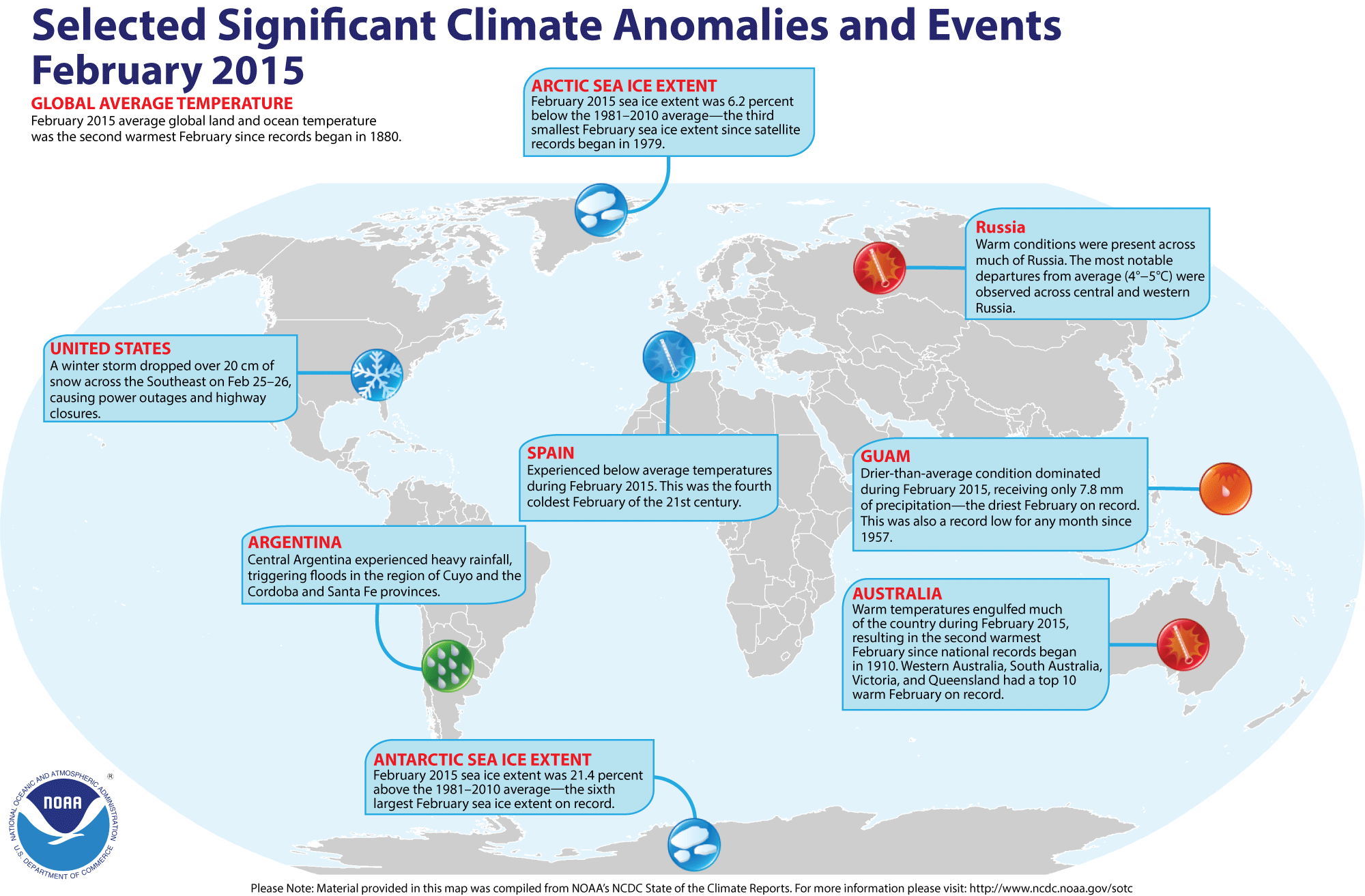
The combined average temperature over global land and ocean surfaces for February 2015 was the second highest for February in the 136-year period of record, at 0.82°C (1.48°F), above the 20th century average of 12.1°C (53.9°F). The warmest February occurred in 1998, which was 0.86°C (1.55°F) above average. Nine of the past 12 months have been either warmest or second warmest on record for their respective months (March and July 2014 were each fourth warmest, while November was seventh warmest).
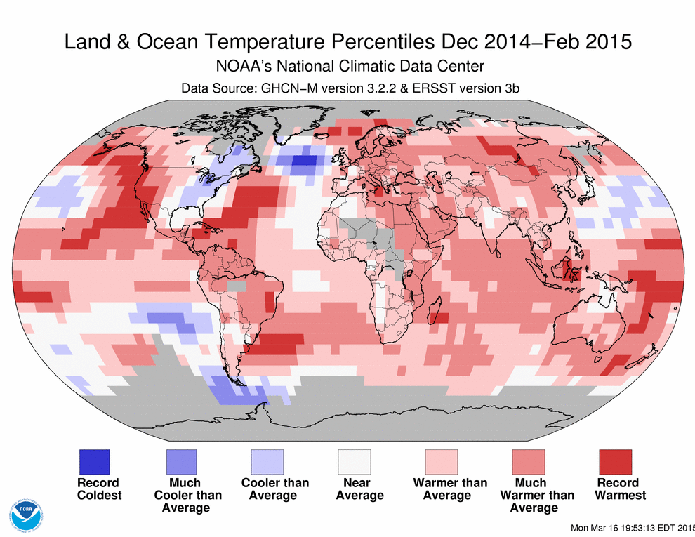
The average global temperature across land surfaces was 1.68°C (3.02°F) above the 20th century average of 3.2°C (37.8°F), the second highest February temperature on record, behind only 2002. This February (2015) was much warmer than last February (2014), when the average global land surface temperature was just 0.31°C (0.56°F) above average and the 44th warmest on record. However, there were some similarities between this February and last, most notably colder-than-average temperatures across the central to eastern United States and much warmer-than-average temperatures over Scandinavia, a result of the subpolar jet stream position during each of those months. In February 2015, cooler to much-cooler-than average conditions overtook the entire eastern half of the United States and the eastern third of Canada, with some record cold pockets seen around the Great Lakes region and part of northeastern Canada near Hudson Bay. The majority of the world's land surfaces, however, were warmer than average, with much-warmer-than average temperatures widespread across Central America, northern and central South America, Australia, most of Africa, and much of Eurasia, including a broad swath that covered most of Russia. In stark contrast to the eastern United States, the western United States was encompassed by record warmth. The warm-cold pattern over the country has been observed over much of the past two years.
Select national information is highlighted below. (Please note that different countries report anomalies with respect to different base periods. The information provided here is based directly upon these data):
- With its second highest maximum February temperature on record and fifth highest minimum, Australia reported its second warmest average February temperature, behind 1983, since national records began in 1910, at 1.93°C (3.01°F) above the 1961–1990 average. Western Australia had the highest departure from average among all states and the Northern Territory, at +2.30°C (+4.14°F), its second warmest February on record. Queensland, Victoria, and South Australia each observed a February among their eight warmest.
- Norway was 4.2°C (7.6°F) warmer than its 1961–1990 average during February, with some regions as much as 6–9°C (11–16°F) warmer than their monthly averages. This marks one of the five warmest Februarys for the country since national records began in 1900.
- Spain was among the few countries in the world with a below-average temperature for February, at 1.1°C (2.0°F) below its 1981–2010 average, marking the fourth coldest February of the 21st century (2005, 2006, and 2012 were cooler).
For the oceans, the February global sea surface temperature was 0.51°C (0.92°F) above the 20th century average of 15.9°C (60.6°F), the third highest for February on record, behind 2010 (warmest) and 1998 (second warmest). After nearly two years of ENSO-neutral conditions, a weak El Niño officially emerged across the central and eastern equatorial Pacific Ocean during February 2015. According to NOAA's Climate Prediction Center, there is about a 50–60 percent chance that El Niño conditions will continue through the Northern Hemisphere summer 2015. This forecast focuses on the ocean surface temperatures between 5°N and 5°S latitude and 170°W to 120°W longitude, called the Niño 3.4 region. However, much of the global ocean temperature warmth this month was driven by record warmth across much of the eastern North Pacific and part of the western equatorial Pacific. An area of record warmth was also observed in the central North Atlantic Ocean, while farther north, much cooler-than-average tempratures and even an area of record cold was observed in the waters between northern Canada and the United Kingdom.
| February | Anomaly | Rank (out of 136 years) | Records | ||||
|---|---|---|---|---|---|---|---|
| °C | °F | Year(s) | °C | °F | |||
| Global | |||||||
| Land | +1.68 ± 0.19 | +3.02 ± 0.34 | Warmest | 2nd | 2002 | +1.70 | +3.06 |
| Coolest | 135th | 1893 | -1.62 | -2.92 | |||
| Ocean | +0.51 ± 0.04 | +0.92 ± 0.07 | Warmest | 3rd | 2010 | +0.57 | +1.03 |
| Coolest | 134th | 1911 | -0.52 | -0.94 | |||
| Land and Ocean | +0.82 ± 0.08 | +1.48 ± 0.14 | Warmest | 2nd | 1998 | +0.86 | +1.55 |
| Coolest | 135th | 1893 | -0.65 | -1.17 | |||
| Northern Hemisphere | |||||||
| Land | +1.94 ± 0.18 | +3.49 ± 0.32 | Warmest | 4th | 2002 | +2.25 | +4.05 |
| Coolest | 133rd | 1893 | -1.95 | -3.51 | |||
| Ocean | +0.56 ± 0.04 | +1.01 ± 0.07 | Warmest | 2nd | 2010 | +0.57 | +1.03 |
| Coolest | 135th | 1904, 1911 | -0.47 | -0.85 | |||
| Land and Ocean | +1.09 ± 0.10 | +1.96 ± 0.18 | Warmest | 2nd | 2002 | +1.10 | +1.98 |
| Coolest | 135th | 1893 | -0.97 | -1.75 | |||
| Southern Hemisphere | |||||||
| Land | +1.00 ± 0.12 | +1.80 ± 0.22 | Warmest | 4th | 2010 | +1.16 | +2.09 |
| Coolest | 133rd | 1917 | -1.03 | -1.85 | |||
| Ties: 2005 | |||||||
| Ocean | +0.49 ± 0.06 | +0.88 ± 0.11 | Warmest | 6th | 1998 | +0.59 | +1.06 |
| Coolest | 131st | 1911 | -0.56 | -1.01 | |||
| Land and Ocean | +0.57 ± 0.07 | +1.03 ± 0.13 | Warmest | 4th | 2010 | +0.67 | +1.21 |
| Coolest | 133rd | 1911 | -0.57 | -1.03 | |||
| Ties: 2007 | |||||||
| Arctic | |||||||
| Land and Ocean | +2.56 ± 0.86 | +4.61 ± 1.55 | Warmest | 5th | 1934 | +3.77 | +6.79 |
| Coolest | 132nd | 1895 | -3.38 | -6.08 | |||


The most current data may be accessed via the Global Surface Temperature Anomalies page.
Seasonal (December–February)

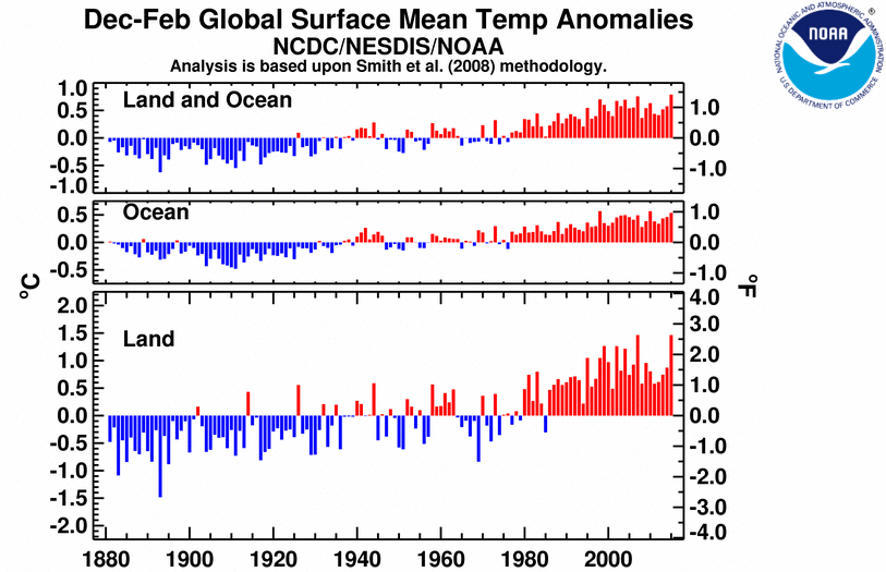
Together, the record warm December, second warmest January, and second warmest February made the combined average temperature over global land and ocean surfaces for the December–February period (austral summer / boreal winter) the highest on record for this period, at 0.79°C (1.42°F) above the 20th century average of 12.1°C (53.8°F), surpassing the previous record warmth of December–February 2006/07 by 0.04°C (0.07°F). The Northern Hemisphere had its warmest winter on record and the Southern Hemisphere had its fourth warmest summer.
The globally-averaged temperature across land surfaces tied with 2007 as the highest on record for December–February, at 1.46°C (2.63°F) above the 20th century average of 8.1°C (46.4°F). Even with cooler-than-average temperatures observed across eastern North America, the Northern Hemisphere land was also record warm for the period, largely due to much warmer-than-average temperatures across southern Mexico, Central America into northern South America, Alaska, and much of Eurasia extending into Africa, with record warmth in the western United States and part of central Siberia and eastern Mongolia. Part of central Siberia had temperatures more than 5°C (9°F) above average, the highest departure from average anywhere in the world during the season, according to the Land & Ocean Temperature Departure from Average map above. The Southern Hemisphere land overall was ninth warmest on record, with only far southern South America cooler than average during austral summer (based on the percentiles map above). Northern South America, eastern Africa, southeastern Asia, and large parts of Australia were much warmer than average.
Select national information is highlighted below. (Please note that different countries report anomalies with respect to different base periods. The information provided here is based directly upon these data):
- The second warmest February on record contributed to Australia's fifth warmest summer (December–February 2014/15) in its 105-year period of record, at 0.86°C (1.55°F) above the 1960–1990 average. The average maximum temperature for this period was fourth highest on record, at 0.94°C (1.69°F) above average. The highest maximum summer temperature was observed in 2013. Western Australia had the greatest departures from average among all states and the Northern Territory, observing its fourth highest maximum temperature, third highest minimum temperature, and overall third highest average daily temperature on record for the season.
- Winter was 1.6°C (2.9°F) warmer than the 1961–1990 average for Germany. According to DWD, Atlantic low pressure systems brough mild weather in December and January. On January 10th, several stations, including Piding in Upper Bavaria, recorded temperatures above 20°C (68°F) for the first time ever in January.
Across the world's oceans, the December–February sea surface temperature was 0.54°C (0.97°F) above the 20th century average of 16.0°C (60.7°F), the third highest for December–February on record behind 1998 and 2010 (tied for record highest). Parts of the western North and western South Atlantic, a large swath of the eastern North Pacific, parts of the tropical central Pacific and western South Pacific, the Indian Ocean off the eastern Madagascar coast, and scattered regions in the Arctic were record warm. An area of the eastern South Pacific, the Southern Ocean south of South America, and part of the central North Atlantic were much cooler than average, with a section of the central North Atlantic between northeastern Canada and the United Kingdom record cold. Additionally, a weak El Niño officially formed during February, ending a nearly two-year streak of ENSO-neutral conditions in the eastern equatorial Pacific Ocean. El Niño conditions are generally associated with enhanced global temperatures, although the weaker the event the smaller the impact is likely to be.
| December–February | Anomaly | Rank (out of 136 years) | Records | ||||
|---|---|---|---|---|---|---|---|
| °C | °F | Year(s) | °C | °F | |||
| Global | |||||||
| Land | +1.46 ± 0.18 | +2.63 ± 0.32 | Warmest | 1st | 2007, 2015 | +1.46 | +2.63 |
| Coolest | 136th | 1893 | -1.48 | -2.66 | |||
| Ties: 2007 | |||||||
| Ocean | +0.54 ± 0.05 | +0.97 ± 0.09 | Warmest | 3rd | 1998, 2010 | +0.57 | +1.03 |
| Coolest | 134th | 1911 | -0.48 | -0.86 | |||
| Land and Ocean | +0.79 ± 0.08 | +1.42 ± 0.14 | Warmest | 1st | 2015 | +0.79 | +1.42 |
| Coolest | 136th | 1893 | -0.62 | -1.12 | |||
| Northern Hemisphere | |||||||
| Land | +1.73 ± 0.21 | +3.11 ± 0.38 | Warmest | 1st | 2015 | +1.73 | +3.11 |
| Coolest | 136th | 1893 | -1.83 | -3.29 | |||
| Ocean | +0.60 ± 0.07 | +1.08 ± 0.13 | Warmest | 1st | 2015 | +0.60 | +1.08 |
| Coolest | 136th | 1910 | -0.47 | -0.85 | |||
| Land and Ocean | +1.03 ± 0.12 | +1.85 ± 0.22 | Warmest | 1st | 2015 | +1.03 | +1.85 |
| Coolest | 136th | 1893 | -0.95 | -1.71 | |||
| Southern Hemisphere | |||||||
| Land | +0.77 ± 0.14 | +1.39 ± 0.25 | Warmest | 9th | 2010 | +0.97 | +1.75 |
| Coolest | 128th | 1904 | -0.82 | -1.48 | |||
| Ocean | +0.51 ± 0.05 | +0.92 ± 0.09 | Warmest | 4th | 1998 | +0.60 | +1.08 |
| Coolest | 133rd | 1911 | -0.50 | -0.90 | |||
| Ties: 2002, 2004 | |||||||
| Land and Ocean | +0.55 ± 0.07 | +0.99 ± 0.13 | Warmest | 4th | 1998 | +0.65 | +1.17 |
| Coolest | 133rd | 1911 | -0.51 | -0.92 | |||
| Arctic | |||||||
| Land and Ocean | +2.17 ± 0.31 | +3.91 ± 0.56 | Warmest | 1st | 2015 | +2.17 | +3.91 |
| Coolest | 136th | 1966 | -2.21 | -3.98 | |||

The most current data may be accessed via the Global Surface Temperature Anomalies page.
Year-to-date (January–February)


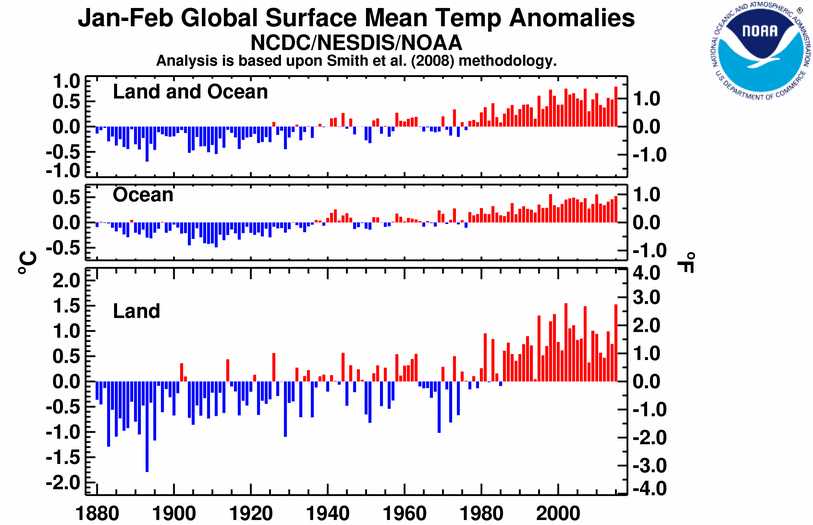
The first two months of 2015 were the warmest such period on record across the world's land and ocean surfaces, at 0.79°C (1.42°F) above the 20th century average. The average global sea surface temperature was the third highest for January–February in the 136-year period of record, behind 1998 and 2010 (tied for highest on record), while the average land surface temperature was second highest, behind only 2002. Most areas around the world were warmer or much warmer than average. Record warmth was scattered across various areas and was particularly notable across parts of the western United States, a large swath of the eastern North Pacific Ocean, regions of the western South Pacific, and parts of the western North Atlantic Ocean. Part of the Great Lakes region, an area of northeastern Canada, and a broad section of the North Atlantic between northern Canada and the United Kingdom were record cold.
| January–February | Anomaly | Rank (out of 136 years) | Records | ||||
|---|---|---|---|---|---|---|---|
| °C | °F | Year(s) | °C | °F | |||
| Global | |||||||
| Land | +1.53 ± 0.20 | +2.75 ± 0.36 | Warmest | 2nd | 2002 | +1.55 | +2.79 |
| Coolest | 135th | 1893 | -1.79 | -3.22 | |||
| Ocean | +0.52 ± 0.05 | +0.94 ± 0.09 | Warmest | 3rd | 1998, 2010 | +0.56 | +1.01 |
| Coolest | 134th | 1911 | -0.49 | -0.88 | |||
| Land and Ocean | +0.79 ± 0.09 | +1.42 ± 0.16 | Warmest | 1st | 2015 | +0.79 | +1.42 |
| Coolest | 136th | 1893 | -0.69 | -1.24 | |||
| Northern Hemisphere | |||||||
| Land | +1.81 ± 0.24 | +3.26 ± 0.43 | Warmest | 2nd | 2002 | +2.02 | +3.64 |
| Coolest | 135th | 1893 | -2.24 | -4.03 | |||
| Ocean | +0.57 ± 0.07 | +1.03 ± 0.13 | Warmest | 1st | 2015 | +0.57 | +1.03 |
| Coolest | 136th | 1904 | -0.49 | -0.88 | |||
| Land and Ocean | +1.04 ± 0.13 | +1.87 ± 0.23 | Warmest | 1st | 2015 | +1.04 | +1.87 |
| Coolest | 136th | 1893 | -1.11 | -2.00 | |||
| Southern Hemisphere | |||||||
| Land | +0.80 ± 0.14 | +1.44 ± 0.25 | Warmest | 8th | 2010 | +1.04 | +1.87 |
| Coolest | 129th | 1904 | -0.88 | -1.58 | |||
| Ocean | +0.50 ± 0.06 | +0.90 ± 0.11 | Warmest | 6th | 1998 | +0.59 | +1.06 |
| Coolest | 131st | 1911 | -0.52 | -0.94 | |||
| Land and Ocean | +0.55 ± 0.08 | +0.99 ± 0.14 | Warmest | 4th | 2010 | +0.65 | +1.17 |
| Coolest | 133rd | 1911 | -0.53 | -0.95 | |||
| Arctic | |||||||
| Land and Ocean | +2.18 ± 0.43 | +3.92 ± 0.77 | Warmest | 3rd | 1981 | +2.77 | +4.99 |
| Coolest | 134th | 1966 | -2.78 | -5.00 | |||

The most current data may be accessed via the Global Surface Temperature Anomalies page.
Precipitation
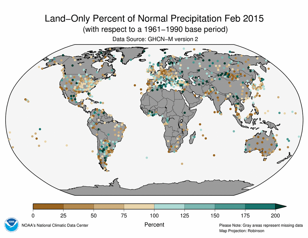
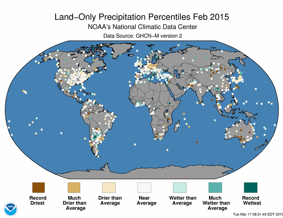
February
The maps below represent precipitation percent of normal (left, using a base period of 1961–1990) and precipitation percentiles (right, using the period of record) based on the GHCN dataset of land surface stations. As is typical, precipitation anomalies during February 2015 varied significantly around the world.
Select national information is highlighted below. (Please note that different countries report anomalies with respect to different base periods. The information provided here is based directly upon these data):
- The end of summer was a dry one for Australia, with February receiving just 49 percent of its average monthly precipitation, the country's 11th driest February on record. The dryness encompassed most of the country, with every state and the Northern Territory reporting below-average rainfall.
- Guam International Airport observed just 7.8 mm of precipitation during February. This was the lowest monthly rainfall for any month at this location in the 1957–2015 record.
Seasonal (December–February)
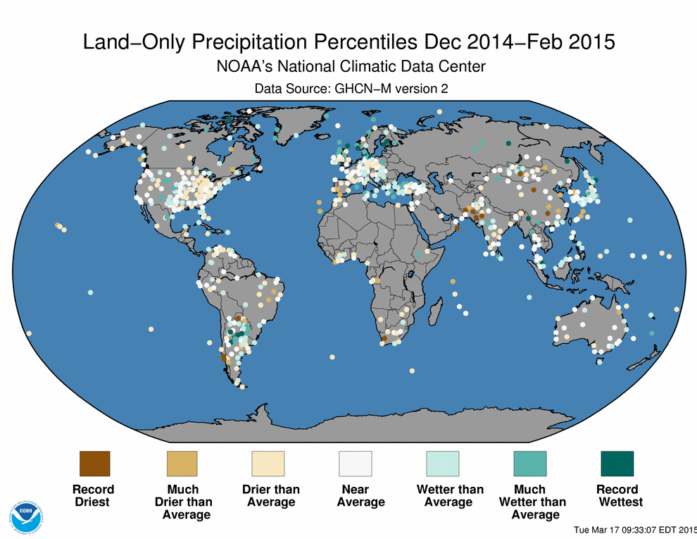
The maps below represent precipitation percent of normal (left) and precipitation percentiles (right) based on the GHCN dataset of land surface stations using a base period of 1961–1990. As is typical, precipitation anomalies during December 2014–February 2015 varied significantly around the world.
- Summer was dry overall in New Zealand, with almost all of the country receiving below-normal (50–79 percent) or much below-normal (less than 50 percent) rainfall for the season. This translated to below-normal soil moistures across extensive areas of New Zealand, according to NIWA.
- Denmark recorded its seventh wettest winter since national records began in 1874, with about 150 percent of the 1961–1990 average rainfall.

References
- Peterson, T.C. and R.S. Vose, 1997: An Overview of the Global Historical Climatology Network Database. Bull. Amer. Meteorol. Soc., 78, 2837-2849.
- Quayle, R.G., T.C. Peterson, A.N. Basist, and C. S. Godfrey, 1999: An operational near-real-time global temperature index. Geophys. Res. Lett., 26, 333-335.
- Smith, T.M. and R.W. Reynolds, 2005: A global merged land air and sea surface temperature reconstruction based on historical observations (1880-1997), J. Clim., 18, 2021-2036.
- Smith et al., 2008, Improvements to NOAA's Historical Merged Land-Ocean Surface Temperature Analysis (1880-2006), J. Climate., 21, 2283-2293.