Contents of this Section:
Global Highlights
- The combined global land and ocean average surface temperature for June 2010 was the warmest on record at 16.2°C (61.1°F), which is 0.68°C (1.22°F) above the 20th century average of 15.5°C (59.9°F). The previous record for June was set in 2005.
- June 2010 was the fourth consecutive warmest month on record (March, April, and May 2010 were also the warmest on record). This was the 304th consecutive month with a global temperature above the 20th century average. The last month with below-average temperature was February 1985.
- The June worldwide averaged land surface temperature was 1.07°C (1.93°F) above the 20th century average of 13.3°C (55.9°F)—the warmest on record.
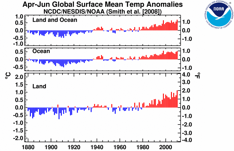
- It was the warmest April–June (three-month period) on record for the global land and ocean temperature and the land-only temperature. The three-month period was the second warmest for the world's oceans, behind 1998.
- It was the warmest June and April–June on record for the Northern Hemisphere as a whole and all land areas of the Northern Hemisphere.
- It was the warmest January–June on record for the global land and ocean temperature. The worldwide land on average had its second warmest January–June, behind 2007. The worldwide averaged ocean temperature was the second warmest January–June, behind 1998.
- Sea surface temperature (SST) anomalies in the central and eastern equatorial Pacific Ocean continued to decrease during June 2010. According to NOAA's Climate Prediction Center, La Niña conditions are likely to develop during the Northern Hemisphere summer 2010.
Please Note: The data presented in this report are preliminary. Ranks and anomalies may change as more complete data are received and processed. Effective with the July 2009 State of the Climate Report, NCDC transitioned to the new version (version 3b) of the extended reconstructed sea surface temperature (ERSST) dataset. ERSST.v3b is an improved extended SST reconstruction over version 2. For more information about the differences between ERSST.v3b and ERSST.v2 and to access the most current data, please visit NCDC's Global Surface Temperature Anomalies page.
Introduction
Temperature anomalies for June 2010 are shown on the dot maps below. The dot map on the left provides a spatial representation of anomalies calculated from the Global Historical Climatology Network (GHCN) dataset of land surface stations using a 1961–1990 base period. The dot map on the right is a product of a merged land surface and sea surface temperature (SST) anomaly analysis developed by Smith et al. (2008). For the merged land surface and SST analysis, temperature anomalies with respect to the 1971–2000 average for land and ocean are analyzed separately and then merged to form the global analysis. For more information, please visit NCDC's Global Surface Temperature Anomalies page.
June


Warmer-than-average conditions dominated the globe during June 2010, with the most prominent warmth in Mexico, northern Africa, and most of Europe, Asia, South America, and the contiguous U.S. Cooler-than-average conditions were present across Scandinavia, southeastern China, and the northwestern contiguous U.S. The world land surface temperature June 2010 anomaly of 1.07°C (1.93°F) was the warmest on record, surpassing the previous June record set in 2005 by 0.12°C (0.22°F). The anomalous warm conditions that affected large portions of each inhabited continent also contributed to the warmest June worldwide land and ocean surface temperature since records began in 1880. The previous June record was set in 2005. Separately, the worldwide ocean surface temperatures during June 2010 were 0.54°C (0.97°F) above the 20th century average—the fourth warmest June on record. Warmer-than-average conditions were present across most of the Atlantic, Indian, and the western Pacific oceans. Meanwhile, cooler-than-average conditions were present across the eastern and equatorial Pacific Ocean, the southern oceans, and a small region in the northwestern Atlantic Ocean. Sea surface temperature (SST) anomalies were below average across the eastern and central equatorial Pacific, as temperatures continued to decrease during June 2010. SST anomalies in the Niño 3.4 region decreased to -0.43°C (-0.77°F), a cooling of 0.34°C (0.61°F) compared to May's anomaly. According to NOAA's Climate Prediction Center (CPC), La Niña conditions are likely to develop during the Northern Hemisphere summer 2010 as SSTs continue to decrease across the equatorial Pacific Ocean.
The June 2010 average temperature across China was 20.5°C (68.9°F), which is 1.0°C (1.8°F) above the 1971–2000 average. According to the Beijing Climate Center (BCC), Inner Mongolia, Heilongjiang, and Jilin (northeastern China) experienced their warmest June since national records began in 1951. Meanwhile, Guizhou (southern China) had its coolest June on record. On June 9th–11th and again on June 23rd–28th, northeastern China was engulfed by heat waves that brought scorching temperatures to the area. Heilongjiang and Jilin set new maximum number of hot days (defined as daily maximum temperatures greater or equal to 35°C [95°F]) records (BCC).
Spain's meteorological office (Agencia Estatal de Meteorología) reported that the country experienced normal-to-slightly above average temperatures during June 2010. Overall, Spain's nationwide average temperature was 0.4°C (0.7°F) above the 1971–2000 average—the coolest June since 1997.
Three-month (April–June)


June 2010 was the fourth consecutive month with reported warmest averaged global land and ocean temperature on record (March, April, and May 2010 were also the warmest on record). When averaging the last three months, the combined global land and ocean surface temperature during April–June 2010 (three-month period) ranked as the warmest April–June on record, with an anomaly of 0.70°C (1.26°F) above the 20th century average. The previous April–June record was set in 1998, which had an anomaly of 0.66°C (1.19°F) above the 20th century average.
During this three-month period, warmer-than-average temperatures enveloped much of world's land surface, with the most notable warm anomalies in Canada, the eastern half of the contiguous U.S., northern Africa, and western Asia. The worldwide land surface temperature during April–June 2010 was 1.12°C (2.02°F) above the 20th century average—the warmest on record. This value surpassed the previous record of 1.02°C (1.84°F) set in 2005. Meanwhile, warmer-than-average temperatures were present across much of the world's oceans, with the exception of cooler-than-average conditions across parts of the southern oceans, the northeastern and southeastern Pacific Ocean, and the northeastern Atlantic Ocean. The worldwide average ocean surface temperature had an anomaly of 0.54°C (0.97°F) above the 20th century average—the second warmest April–June on record, behind 1998.
Year-to-date (January–June)
The  January–June 2010 map of temperature anomalies shows that for the first half of the year anomalous warm temperatures were present over much of the world, with the exception of cooler-than-average conditions across the higher-latitude southern oceans, the northern Pacific Ocean, along the western South American coast, Mongolia, northeastern China, the south central and southeastern U.S., central Russia, and parts of Scandinavia. The combined global average land and ocean surface temperature for January–June period was the warmest such period on record. This value is 0.68°C (1.22°F) above the 20th century average. Separately, the average worldwide land surface temperature ranked as the second warmest on record, behind 2007, while the worldwide average ocean surface temperature ranked as the second warmest January–June on record—behind 1998.
The average position of the upper-level ridges of high pressure and troughs of low pressure (depicted by positive and negative 500-millibar height anomalies on the  June 2010 map, respectively) are generally reflected by areas of positive and negative temperature anomalies at the surface, respectively. For other Global products, please see the Climate Monitoring Global Products page.
Images of sea surface temperature conditions are available for all weeks during 2009 from the weekly SST page.
Temperature Rankings and Graphics
| June | Anomaly | Rank (out of 131 years) | (Next) Warmest on Record | ||||
|---|---|---|---|---|---|---|---|
| °C | °F | Year | °C | °F | |||
| Global | |||||||
| Land | +1.07 | +1.93 | Warmest | (2005) | +0.95 | +1.71 | |
| Ocean | +0.54 | +0.97 | 4th warmest | 1998 | +0.58 | +1.04 | |
| Land and Ocean | +0.68 | +1.22 | Warmest | (2005) | +0.66 | +1.19 | |
| Northern Hemisphere | |||||||
| Land | +1.22 | +2.20 | Warmest | (2006) | +1.11 | +2.00 | |
| Ocean | +0.54 | +0.97 | 4th warmest | 2009 | +0.62 | +1.12 | |
| Land and Ocean | +0.79 | +1.42 | Warmest | (2006)* | +0.73 | +1.31 | |
| Southern Hemisphere | |||||||
| Land | +0.66 | +1.19 | 5th warmest | 2005 | +1.03 | +1.85 | |
| Ocean | +0.55 | +0.99 | 2nd warmest* | 1998 | +0.60 | +1.08 | |
| Land and Ocean | +0.56 | +1.01 | 4th warmest* | 1998 | +0.63 | +1.13 | |
*Signifies a tie


| April–June | Anomaly | Rank (out of 131 years) | (Next) Warmest on Record | ||||
|---|---|---|---|---|---|---|---|
| °C | °F | Year | °C | °F | |||
| Global | |||||||
| Land | +1.12 | +2.02 | Warmest | (2005) | +1.02 | +1.84 | |
| Ocean | +0.54 | +0.97 | 2nd warmest | 1998 | +0.56 | +1.01 | |
| Land and Ocean | +0.70 | +1.26 | Warmest | (1998) | +0.66 | +1.19 | |
| Northern Hemisphere | |||||||
| Land | +1.25 | +2.25 | Warmest | (2007) | +1.16 | +2.09 | |
| Ocean | +0.55 | +0.99 | 2nd warmest | 2005 | +0.56 | +1.01 | |
| Land and Ocean | +0.81 | +1.46 | Warmest | (2005) | +0.74 | +1.33 | |
| Southern Hemisphere | |||||||
| Land | +0.78 | +1.40 | 3rd warmest | 2005 | +0.98 | +1.76 | |
| Ocean | +0.56 | +1.01 | 2nd warmest | 1998 | +0.61 | +1.10 | |
| Land and Ocean | +0.58 | +1.04 | 2nd warmest* | 1998 | +0.64 | +1.15 | |
*Signifies a tie

| January–June | Anomaly | Rank (out of 131 years) | (Next) Warmest on Record | ||||
|---|---|---|---|---|---|---|---|
| °C | °F | Year | °C | °F | |||
| Global | |||||||
| Land | +1.07 | +1.93 | 2nd warmest | 2007 | +1.12 | +2.02 | |
| Ocean | +0.54 | +0.97 | 2nd warmest | 1998 | +0.56 | +1.01 | |
| Land and Ocean | +0.68 | +1.22 | Warmest | (1998) | +0.66 | +1.19 | |
| Northern Hemisphere | |||||||
| Land | +1.15 | +2.07 | 3rd warmest | 2007 | +1.34 | +2.41 | |
| Ocean | +0.53 | +0.95 | Warmest | (1998) | +0.52 | +0.94 | |
| Land and Ocean | +0.77 | +1.39 | 2nd warmest | 2007 | +0.78 | +1.40 | |
| Southern Hemisphere | |||||||
| Land | +0.86 | +1.55 | 2nd warmest | 2005 | +0.90 | +1.62 | |
| Ocean | +0.56 | +1.01 | 2nd warmest | 1998 | +0.60 | +1.08 | |
| Land and Ocean | +0.60 | +1.08 | 2nd warmest | 1998 | +0.63 | +1.13 | |
*Signifies a tie


The most current data may be accessed via the Global Surface Temperature Anomalies page.
Precipitation
The maps below represent anomaly values based on the GHCN dataset of land surface stations using a base period of 1961–1990. Precipitation anomalies on a month-to-month basis are often highly variable across the globe and even within regions. The areas with the wettest anomalies during June 2010 included southern India, southern China, southern Europe, the midwestern contiguous U.S., and parts of northwestern South America. The driest anomalies were present across northern India and across parts eastern Asia, northeastern South America, and Australia.
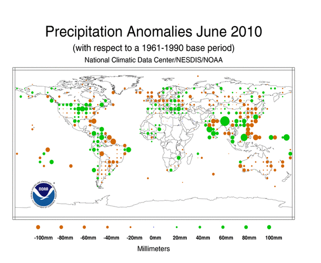

According to the Beijing Climate Center (BCC), the provinces of Guizhou, Fujian, and Qinghai had above-average precipitation during June 2010, ranking as the second wettest June since national records began in 1951. The BCC also reported that ten provinces in southern China were affected by storms that brought heavy rainfall across the area—resulting in record breaking daily rainfall in some places of Jiangxi and Fujian. The copious rainfall prompted floods that killed nearly 200 people. Meanwhile, the province of Jiangsu had its driest June on record, while Shanxi had its second driest on record. Overall, the monthly averaged precipitation in China during June 2010, 95.0 mm (3.7 inches), was near the 1971–2000 average.
According to the German Meteorological Service (Deutscher Wetterdienst), the monthly averaged precipitation across Germany was 48.8 mm (1.9 inches), which is 35.8 mm (1.4 inches) below average. The nationally-averaged precipitation value ranks as the seventh driest June since 1901.
Most of Australia experienced below-average precipitation during June 2010, according to Australia's Bureau of Meteorology (BoM). The monthly averaged precipitation for June 2010 was 11.2 mm (0.4 inch), which is 52 percent below the 1961–1990 average—the fourth driest June since national records began in 1900 and the driest June since 1984. The BoM reported that all states and territories experienced drier-than-average conditions, with less than five percent of the country receiving its mean monthly precipitation for June.
According to New Zealand's National Institute of Water and Atmospheric Research (NIWA), June 2010 was a very wet month in most regions of the country, with Marlborough and parts of Waikato and Bay of Plenty receiving double their average June rainfall. NIWA reported that Whakatane and Blenheim had their wettest June since records began in 1952 and 1927, respectively.
The first six months of 2010 were the second driest on record and the driest since 1929 for the United Kingdom as a whole, according to the United Kingdom Met Office. The average rainfall during January–June 2010 was 362.5 mm (14.3 inches), which is 86.8 mm (3.4 inches) above January–June 1929. The January–June long-term average is 511.7 mm (20.1 inches).
Additional details on flooding and drought can also be found on the June 2010 Global Hazards page.
For additional details on precipitation and temperatures in June, see the Global Hazards page.
References
Peterson, T.C. and R.S. Vose, 1997: An Overview of the Global Historical Climatology Network Database. Bull. Amer. Meteorol. Soc., 78, 2837-2849.
Quayle, R.G., T.C. Peterson, A.N. Basist, and C. S. Godfrey, 1999: An operational near-real-time global temperature index. Geophys. Res. Lett., 26, 333-335.
Smith, T.M., and R.W. Reynolds (2005), A global merged land air and sea surface temperature reconstruction based on historical observations (1880-1997), J. Clim., 18, 2021-2036.
Smith, et al (2008), Improvements to NOAA's Historical Merged Land-Ocean Surface Temperature Analysis (1880-2006), J. Climate., 21, 2283-2293.