Global Highlights:
|
Contents of this Section: |
| The data presented in this report are preliminary. Ranks and anomalies may change as more complete data are received and processed. The most current data may be accessed via the Global Surface Temperature Anomalies page. |
Temperature anomalies for March-May and May 2005 are shown on the
two maps below. These dot maps use anomalies that were calculated
from the Global Historical Climatology Network (GHCN) data set of
land surface stations using a 1961-1990 base period. During the
boreal spring, above average temperatures occurred over Alaska,
Canada, Venezuela, Russia, the western half of the U.S., the
majority of Africa, southeastern Asia and most of Australia. Cooler
than average temperatures were observed over the eastern seaboard
of the U.S., central Mexico, Finland, western Mongolia and parts of
Japan. Despite a brief heat wave that
occurred in India during the week of May 17th, central areas of
India had cold anomalies for the season. |
 larger image |
 larger image |
| The map below is a weekly product based on data from the Comprehensive Ocean-Atmosphere Data Set (COADS) of SST data. During May 2005, slightly warmer than average conditions occurred over large parts of the western and central Pacific, reflecting a transition from El Niño conditions to a neutral ENSO phase. SSTs were also warmer than average in much of the northern Pacific and northern Atlantic. Cooler than average SSTs were observed off the eastern coast of the U.S., the western coast of Ecuador and Peru, as well as in the Gulf of Guinea southward along the coast of Africa to Angola. |
 larger image |
| The mean position of upper level ridges of high pressure and troughs of low pressure (depicted by positive and negative 500 millibar height anomalies on the May 2005 and the March-May 2005 maps) are generally reflected by areas of positive and negative temperature anomalies at the surface, respectively. For other Global products see the Climate Monitoring Global Products page. |
| Images of sea surface temperature conditions are available for all months during 2005 at the weekly SST page |
|
| Current Month / Seasonal / Year-to-date |
| May | Anomaly | Rank | Warmest Year on Record |
|---|---|---|---|
| Global Land Ocean Land and Ocean |
+0.80°C (+1.44°F) +0.43°C (+0.77°F) +0.54°C (+0.97°F) |
4th warmest 2nd warmest 2nd warmest |
1998 (+0.93°C/1.67°F) 1998 (+0.53°C/0.95°F) 1998 (+0.65°C/1.17°F) |
| Northern Hemisphere Land Ocean Land and Ocean |
+0.82°C (+1.48°F) +0.53°C (+0.95°F) +0.65°C (+1.17°F) |
4th warmest 1st warmest 2nd warmest |
2001 (+0.98°C/1.76°F) 2nd - 1998 (+0.51°C/0.92°F) 1998 (+0.66°C/1.19°F) |
| Southern Hemisphere Land Ocean Land and Ocean |
+0.74°C (+1.33°F) +0.38°C (+0.68°F) +0.45°C (+0.81°F) |
4th warmest 5th warmest 4th warmest |
2002 (+0.98°C/1.76°F) 1998 (+0.56°C/1.01°F) 1998 (+0.64°C/1.15°F) |
 larger image |
 larger image |
| March-May | Anomaly | Rank | Warmest Year on Record |
|---|---|---|---|
| Global Land Ocean Land and Ocean |
+1.07°C (+1.93°F) +0.42°C (+0.76°F) +0.62°C (+1.12°F) |
3rd warmest 2nd warmest 2nd warmest |
2002 (+1.10°C/1.20°F) 1998 (+0.51°C/0.92°F) 1998 (+0.68°C/1.22°F) |
| Northern Hemisphere Land Ocean Land and Ocean |
+1.08°C (+1.94°F) +0.48°C (+0.86°F) +0.72°C (+1.30°F) |
4th warmest 2nd warmest tied for warmest |
2000 (+1.17°C/2.11°F) 1998 (+0.49°C/0.88°F) 1998 (+0.72°C/+1.30°F) |
| Southern Hemisphere Land Ocean Land and Ocean |
+0.87°C (+1.57°F) +0.40°C (+0.72°F) +0.49°C (+0.88°F) |
3rd warmest 5th warmest 3rd warmest |
1998 (+1.03°C/1.85°F) 1998 (+0.53°C/0.95°F) 1998 (+0.63°C/1.13°F) |
 larger image |
 larger image |
| January-May | Anomaly | Rank | Warmest Year on Record |
|---|---|---|---|
| Global Land Ocean Land and Ocean |
+0.92°C (+1.66°F) +0.43°C (+0.77°F) +0.58°C (+1.04°F) |
4th warmest 2nd warmest 3rd warmest |
2002 (+1.24°C/2.23°F) 1998 (+0.52°C/0.94°F) 1998 (+0.71°C/1.30°F) |
| Northern Hemisphere Land Ocean Land and Ocean |
+0.90°C (+1.62°F) +0.48°C (+0.86°F) +0.65°C (+1.17°F) |
9th warmest 2nd warmest 4th warmest |
2002 (+1.40°C/2.52°F) 1998 (+0.51°C/0.92°F) 1998 (+0.79°C/1.42°F) |
| Southern Hemisphere Land Ocean Land and Ocean |
+0.82°C (+1.48°F) +0.42°C (+0.76°F) +0.50°C (+0.90°F) |
2nd warmest 5th warmest 3rd warmest |
1998 (+0.89°C/1.60°F) 1998 (+0.54°C/0.97°F) 1998 (+0.61°C/1.10°F) |
 larger image |
 larger image |
The most current data may be accessed via the Global Surface Temperature Anomalies page.
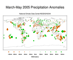
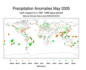
The maps below represent anomaly values based on the GHCN data set
of land surface stations using a base period of 1961-1990. During
the 2005 boreal spring, above average precipitation fell over the
the Caribbean, northwestern, northeastern and southeastern portions
of the U.S., southern Brazil and Uruguay, the western coast of
Australia, western Europe and far eastern Europe. Below average
precipitation was observed along the Gulf of Alaska, the U.S.
central Great Plains and middle Mississippi Valley, Peru, parts of
Argentina, the majority of Australia, the Philippines and most of
southeastern Asia. |
 larger image |
 larger image |
|
|
Peterson, T.C. and R.S. Vose, 1997: An Overview of the Global
Historical Climatology Network Database. Bull. Amer. Meteorol.
Soc., 78, 2837-2849. |
 NOAA's National Centers for Environmental Information

