PLEASE NOTE: The ranks and temperature anomalies in this report represent the values known at the time the report was issued. The actual ranks will change as subsequent years are added to the dataset. The anomalies themselves may change slightly as missing or erroneous data is resolved. Also, in 2009, NCDC switched to ERSST version 3b (from version 2) as a component of its global surface temperature dataset. Because the versions have slightly different methodologies, the calculated temperature anomalies will differ slightly. For more information about this switch please see the Global Surface Temperature Anomalies FAQ .

| The 2005 global temperature was statistically
indistinguishable from the standing record set in 1998. One data
set, in use at NCDC since the late 1990s, produced a global annual
temperature for 2005 that was slightly below 1998 (below left). An
improved data set, which incorporates innovative algorithms that
better account for factors such as changes in spatial coverage and
evolving observing methods, results in 2005 being slightly warmer
than 1998. (below right) |
| The time series on the left shows that the global
annual temperature for combined land and ocean surfaces in 2005 was
0.58°C (1.04°F) above average, ranking 2nd. The time series
from the improved
Smith & Reynolds data set on the right provides a global
temperature of 0.62°C (1.12°F) above the 1880-2004 mean,
while 1998 was 0.59°C (1.06°F) above average. This data set
also provides for the calculation of uncertainties in global
temperature attributable to factors such as changes in spatial coverage and evolving
observing methods. The range of uncertainty is shown for each
year with the uncertainty bounds smaller in more recent years as
sampling and random errors decrease with time due to improved
coverage and better instruments and measurement techniques. |
| When calculating global temperatures, NCDC
scientists, as well as those at NASA and in the United Kingdom, use
methods that address areas of the globe with sparse observations or
measurement biases. The various methodologies result in very small
differences (on the order of a few hundredths of a degree Celsius)
between the global temperature estimates, and these differences can
affect individual yearly rankings. Although the ranking of
individual years may differ slightly from data set to data set, all
records indicate that during the past century, global surface
temperatures have increased at a rate near 0.6°C/century
(1.1°F/century), but the trend has been three times larger
since 1976, with some of the largest temperature increases
occurring in the high latitudes. |
| The widespread anomalous warmth in 2005 is evident
in the map to the lower left. Temperature anomalies in 1998 are
shown in the map to the right. |
|
The 1880-2004 average combined land and ocean annual
temperature is 13.9°C (56.9°F), the annually averaged land
temperature for the same period is 8.5°C (47.3°F), and the
long-term annually averaged sea surface temperature is 16.1°C
(60.9°F). |

larger image
|
Warmer than average
conditions occurred throughout most land areas of the world in
2005. The largest anomalies were widespread throughout high
latitude regions of the Northern Hemisphere that include much of
Russia, Scandinavia, Canada and Alaska. Temperatures in these
regions were 3-5°C (5.4-9.0°F) above the 1961-1990 average.
There were no widespread areas of negative anomalies.
The map to the left was created using data from the
Global
Historical Climatology Network (GHCN), a network of more than
7,000 land surface observing stations. |
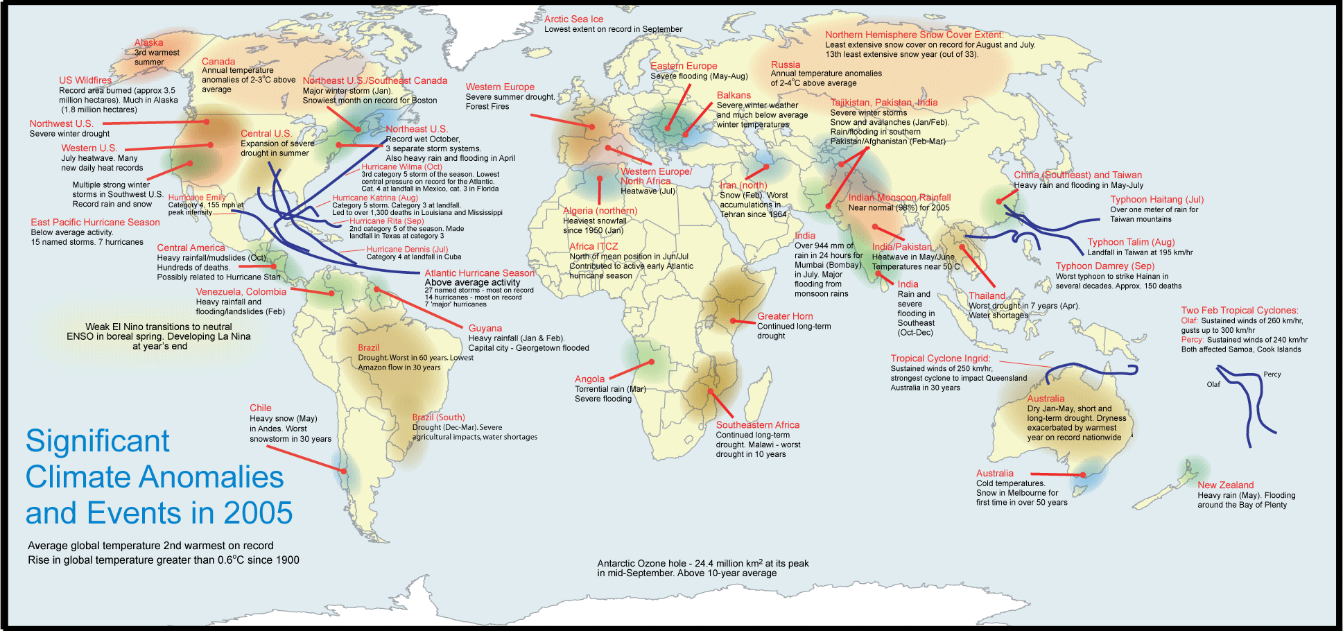
Notable temperature extremes in 2005 include a
severe heat wave that gripped the southwestern United States during
early to mid-July. Maximum temperatures above 40°C (104°F)
affected parts of Nevada, California, Arizona and southern Utah.
Numerous temperature records were set around the region. Las Vegas,
NV tied their all-time record high temperature of 47.2°C
(117°F) on the 19th. Death Valley had 7 consecutive days (July
14-20) with high temperatures equal to or above 51.7°C
(125°F). Across Australia, exceptionally warm and dry weather
prevailed during March-May 2005. The Australian mean temperature
during March-May was 1.62°C (2.92°F) above the long-term
average, which is the warmest on record.
In February, extremely cold temperatures affected much of the
Balkan region for the first half of the month. In Sevlievo,
Bulgaria, a 50-year temperature record was broken when temperatures
reached as low as -34°C (-29°F). For more information on
temperature extremes during 2005 see the annual report of Significant
Events
Additional information on other notable weather events can be found
in the Significant
Events section of this report.
|

larger image
|
Global precipitation
in 2005 was near the 1961-1990 average. Regionally drier than
average conditions were widespread across eastern Australia,
parts of Western Europe, and the U.S. Mississippi Valley and
southern Great Plains region. In Australia, Victoria and South
Australia experienced the second-driest May on record. In the U.S.,
Chicago's O'Hare International Airport had the driest spring,
summer and fall on record with a total of 420 mm (16.54
inches).
Little to no rain has fallen in Brazil since December 2004.
Rainfall was much below average in the Amazon Basin in 2005,
producing the worst drought in 60 years in some parts of the region
and resulting in the lowest water levels in at least 30 years along
the world's second longest river. Across southeastern Africa,
long-term drought affected parts of Mozambique, southern Malawi and
Zimbabwe. For further information on precipitation events during
2005, see the annual report of Significant
Events. |
In contrast, several regions of the globe
experienced heavy precipitation during 2005. India monsoon rainfall
was near normal (98 percent). In July, a new 24-hour rainfall event
record was established on the 26th in the city of Mumbai, when over
944 mm (37 inches) of rain fell. A winter storm brought heavy
snowfall to much of the northeastern U.S. Boston recorded it's
snowiest month on record in January with 1095 mm (43.1 inches) of
snow. In Colombia, heavy rains in October and November triggered
floods and landslides. In Saudi Arabia, heavy rains during January,
produced some of the worst flooding in 20 years in the city of
Medina. In August, heavy rainfall affected areas of central and
eastern Europe with flooding reported in sections of Romania,
Hungary and Macedonia. Farther to the west, flooding also affected
areas of Germany, Austria and Switzerland. For more information
about precipitation extremes during 2005, see the annual report of
Significant
Events.
Additional information on other notable weather events can be found
in the Significant
Events section of this report.
|
NOAA's National Climatic Data Center is the
world's largest active archive of weather data. The preliminary
temperature and precipitation rankings are available from the
center by calling: 828-271-4800.
NOAA works closely with the academic and science communities on
climate-related research projects to increase the understanding of
El Niño and improve forecasting techniques. NOAA's Climate
Prediction Center monitors, analyzes and predicts climate events
ranging from weeks to seasons for the nation. NOAA also operates
the network of data buoys and satellites that provide vital
information about the ocean waters, and initiates research projects
to improve future climate forecasts. |
References:
Quayle, R. G., T. C. Peterson, A. N. Basist, and C. S. Godfrey,
1999: An operational near-real-time global temperature index.
Geophys. Res. Lett., 26, 333-335.
Smith, T. M., and R. W. Reynolds (2005), A global merged land air
and sea surface temperature reconstruction based on historical
observations (1880-1997), J. Clim., 18,
2021-2036.
|


