Global Highlights:
|
Contents of this Section: |
| The data presented in this report are preliminary. Ranks and anomalies may change as more complete data are received and processed. The most current data may be accessed via the Global Surface Temperature Anomalies page. |
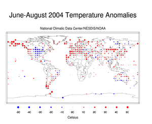
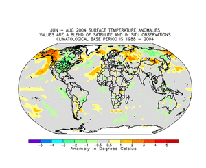
The two maps below utilize different base periods and may reflect
different anomaly values of land surface temperatures. The dot map
on the left uses anomalies that were calculated from the Global
Historical Climatology Network (GHCN) data set of land surface
stations using a 1961-1990 base period. The map on the right is a
blended product
which uses satellite and surface anomaly values of measured land
and ocean temperatures as well as SSTs with the base period of
1988-2004. Both maps reflect conditions during summer 2004,
indicating above average temperatures in Alaska, Mongolia,
Argentina and Iceland, with cooler than average temperatures over
most of the U.S., parts of far eastern Russia and portions of
Brazil. During the month of August
2004, above average temperatures occurred in Europe, the
pacific northwest of the U.S. and Alaska while cooler than average
conditions occurred in the central portion of the U.S., parts of
Brazil and western Australia. |
 |
 |
Current Month / Seasonal /
Year-to-date
|
| August | Anomaly | Rank | Warmest Year on Record |
|---|---|---|---|
| Global Land Ocean Land and Ocean |
+0.47°C (+0.85°F) +0.42°C (+0.76°F) +0.44°C (+0.80°F) |
12th warmest 4th warmest 6th warmest |
1998
(+0.97°C/1.75°F) 1998 (+0.50°C/0.90°F) 1998 (+0.64°C/1.15°F) |
| Northern Hemisphere Land Ocean Land and Ocean |
+0.62°C (+1.12°F) +0.58°C (+1.04°F) +0.59°C (+1.06°F) |
8th warmest 3rd warmest 4th warmest |
2003
(+1.08°C/1.94°F) 2003 (+0.61°C/1.10°F) 2003 (+0.80°C/1.44°F) |
| Southern Hemisphere Land Ocean Land and Ocean |
+0.05°C (+0.09°F) +0.31°C (+0.56°F) +0.26°C (+0.47°F) |
49th warmest 7th warmest 12th warmest |
1884
(+1.42°C/2.56°F) 1998 (+0.42°C/0.76°F) 1998 (+0.47°C/0.85°F) |
 |
 |
|
 |
 |
|
 |
 |
The most current data may be accessed via the Global Surface Temperature Anomalies page.
The maps below represent anomaly values based on the GHCN data set
of land surface stations using a base period of 1961-1990. The map
to the left is precipitation anomalies measured in millimeters, the
map to the right is the percentage of average (1961-1990)
precipitation. During June-August 2004, much above average
precipitation fell across the eastern half of the U.S., Scandinavia
and western Europe. Below average precipitation was observed in
Alaska, India and eastern Australia. During the month of August
2004, above average precipitation occurred in the southeastern
U.S., Chile and coastal Alaska while drier than average conditions
were observed in the southern Brazil, Malaysia and Norway. |
 |
 |
The satellite images below were acquired from SSM/I satellite data using a base period of 1988-2004. The map on the left reflects surface liquid wetness conditions, while the map on the right reflects snow cover conditions for the month. Snow covered areas that are normally snow-free during this month will appear drier than average on the wetness image since a wetness value cannot be determined for regions that are snow covered. Data in these areas that are normally snow covered are displayed as missing. This is due to the snow crystalline structure which produces a considerable amount of scatter and makes it difficult for the SSM/I to accurately detect the surface conditions. The SSM/I products are experimental and are under continuing review and development. Additional data and information can be found on the SSM/I Browser. |
 |
 |
|
|
References: Peterson, T.C. and R.S. Vose, 1997: An Overview of the Global
Historical Climatology Network Database. Bull. Amer. Meteorol.
Soc., 78, 2837-2849. |
 NOAA's National Centers for Environmental Information
 Introduction