Global Highlights:
|
Contents of this Section: |
| The data presented in this report are preliminary. Ranks and anomalies may change as more complete data are received and processed. The most current data may be accessed via the Global Surface Temperature Anomalies page. |
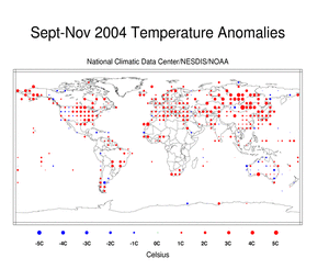
Temperature anomalies for the boreal fall are shown on the two
maps* below. The dot map on the left uses anomalies that were
calculated from the Global Historical Climatology Network (GHCN)
data set of land surface stations using a 1961-1990 base period.
The map on the right is a blended product
which uses satellite and surface anomaly values of measured land
and ocean temperatures as well as SSTs with the base period of
1988-2004. Both maps reflect conditions during boreal fall
(September-November) 2004, indicating above average temperatures in
the eastern half of the U.S., Japan, the majority of Asia, Europe
and Alaska, with cooler than average temperatures over western
Mongolia, parts of Australia, the northern Rockies in the U.S., and
the Caribbean. During the month of November
2004, above average temperatures occurred in Russia, the United
Kingdom, Alaska, the southeastern U.S. and Japan while cooler than
average conditions occurred in the western U.S., Algeria and
eastern Australia. |
 |
 |
Above average sea surface temperatures are also evident in the blended product, above right. Warmer than average conditions covered large parts of the central and eastern Pacific in association with weak El Niño conditions. Sea surface temperatures were also warmer than average in much of the northern Pacific. The combination of anomalous warmth over many land and ocean areas led to a record warm November and boreal fall (September-November) for land surfaces and for the combined land and ocean surfaces as shown in the table a graphs below. Values for the Northern and Southern Hemisphere are also included.
The mean position of upper level ridges of high pressure and troughs of low pressure (depicted by positive and negative 500 millibar height anomalies on the September-November 2004 and November 2004 maps) are generally reflected by areas of positive and negative temperature anomalies at the surface, respectively. For other Global products see the Climate Monitoring Global Products page.
Current Month / Seasonal /
Year-to-date
|
| November | Anomaly | Rank | Warmest Year on Record |
|---|---|---|---|
| Global Land Ocean Land and Ocean |
+1.26°C (+2.27°F) +0.50°C (+0.90°F) +0.73°C (+1.31°F) |
warmest 2nd warmest warmest |
2nd -
2001(+1.04°C/1.87°F) 1997 (+0.58°C/1.04°F) 2nd - 2001 (+0.64°C/1.15°F) |
| Northern Hemisphere Land Ocean Land and Ocean |
+1.58°C (+2.84°F) +0.60°C (+1.08°F) +1.00°C (+1.80°F) |
warmest warmest warmest |
2nd -
2001(+1.42°C/2.56°F) 2nd - 2003 (+0.58°C/1.04°F) 2nd - 2001 (+0.84°C/1.51°F) |
| Southern Hemisphere Land Ocean Land and Ocean |
+0.31°C (+0.56°F) +0.43°C (+0.77°F) +0.41°C (+0.74°F) |
17th warmest 7th warmest 7th warmest |
1990
(+0.90°C/1.62°F) 1941 (+0.70°C/1.26°F) 1941 (+0.61°C/1.10°F) |
 |
 |
|
 |
 |
|
 |
 |
The most current data may be accessed via the Global Surface Temperature Anomalies page.
The maps below represent anomaly values based on the GHCN data set
of land surface stations using a base period of 1961-1990. The map
to the left is precipitation anomalies measured in millimeters, the
map to the right is the percentage of average (1961-1990)
precipitation. During September-November 2004, much above average
precipitation fell in the southeastern quarter of the U.S., Alaska,
Japan, Iceland, and the Caribbean. Below average precipitation was
observed in southeastern Asia, northwestern U.S., France, Spain and
parts of Brazil. During the month of November
2004, above average precipitation occurred in the southern
U.S., the Caribbean, Norway and parts of eastern Australia while
drier than average conditions were observed in India, Thailand,
northwestern U.S. and western Europe. |
 |
 |
The satellite images below were acquired from SSM/I satellite data using a base period of 1988-2004. The map on the left reflects surface liquid wetness conditions, while the map on the right reflects snow cover conditions for the month. Snow covered areas that are normally snow-free during this month will appear drier than average on the wetness image since a wetness value cannot be determined for regions that are snow covered. Data in these areas that are normally snow covered are displayed as missing. This is due to the snow crystalline structure which produces a considerable amount of scatter and makes it difficult for the SSM/I to accurately detect the surface conditions. The SSM/I products are experimental and are under continuing review and development. Additional data and information can be found on the SSM/I Browser. |
 |
 |
|
|
References: Peterson, T.C. and R.S. Vose, 1997: An Overview of the Global
Historical Climatology Network Database. Bull. Amer. Meteorol.
Soc., 78, 2837-2849. |
 NOAA's National Centers for Environmental Information
 Introduction