Issued: 18 January 2017
NH Snow Cover Extent
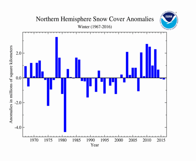
The Northern Hemisphere snow cover extent (SCE) during winter (December 2015-February 2016) was 120,000 square km (46,000 square miles) below the 1981-2010 average— the 20th smallest winter SCE for the Northern Hemisphere since records began in 1967 and smallest since 2006-07. The North American winter SCE was above average while the Eurasian winter SCE was below average. Northern Hemisphere winter SCE has changed only slightly in the 50-year record, with a seasonal increase of about 0.4 percent per decade.
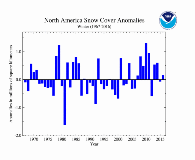
Across North America during the 2015-16 winter, the SCE was 150,000 square km (58,000 square miles) below the 1981-2010 average, the 19th smallest on record. For December, the snow cover was slightly below average. During January, several large winter storms moved across North America and increased the monthly snow cover to the 6th largest on record at 810,000 square km (320,000 square miles) above the 1981-2010 average. A warm end of January and warmer-than-average February arcoss North America caused the snow cover extent to shrink to below-average levels. The February SCE for North America was 40,000 square km (170,000 square miles) below average, the 13th smallest on record. The North American SCE for winter is increasing at an average rate of 0.3 percent per decade. For more information on the snow season across the U.S., please read the U.S. annual snow report.
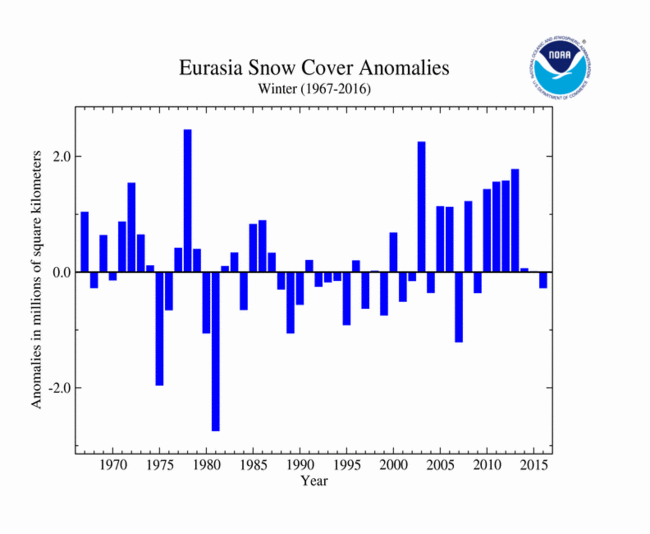
In Eurasia, the winter SCE for 2015-16 was 270,000 square km (104,000 square miles) below average and the 16th smallest winter SCE on record for the continent. This was also the smallest winter SCE since 2006/07. Similar to North America, the Eurasian SCE was below average during December and February and above-average during January. Rapid snow melt in late January and February caused the continental SCE to drop to fourth lowest on record for February at 1.65 million square km (640,000 square miles) below average. For the entire season, SCE for Eurasia is increasing at an average rate of 0.4 percent per decade.
Sea Ice Extent
Arctic sea ice, which is measured from passive microwave instruments onboard NOAA satellites, usually expands during the cold season to a March maximum, and then contracts during the warm season to a September minimum. According to the National Snow and Ice Data Center (NSIDC), during each month of 2016, the Arctic sea ice extent was below average. In fact, seven of the 12 months of 2016 had a record small Arctic sea ice extent. When averaged for the entire year, the Arctic sea ice extent was 12.6 percent below average, the smallest on record.
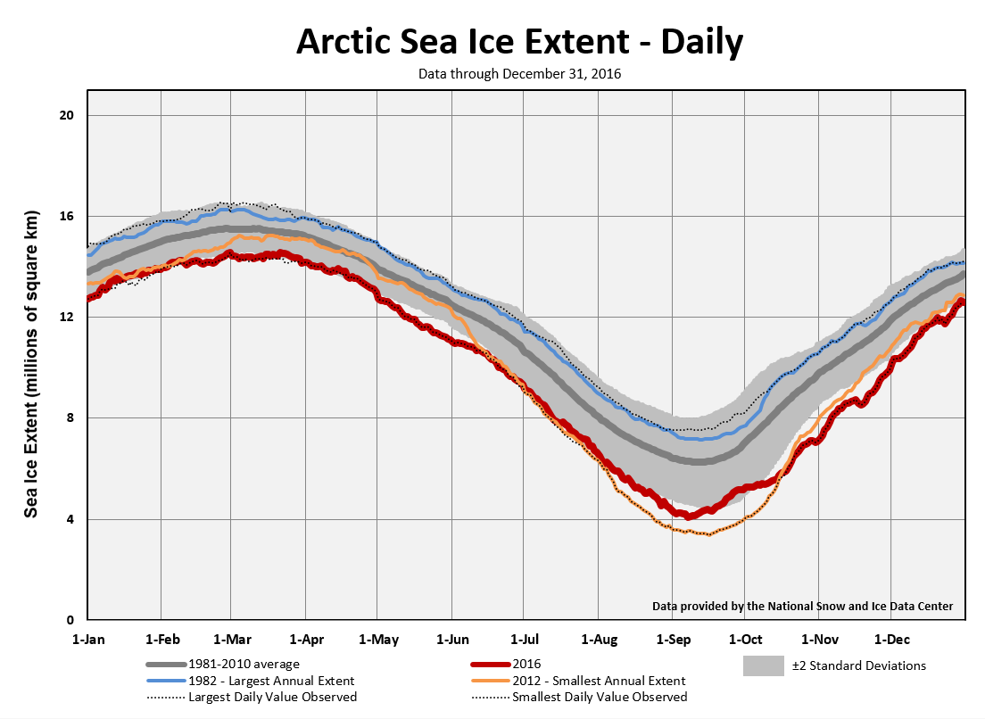
On March 24th, the Arctic sea ice reached its annual maximum extent, marking the start of the annual melt season. The 2016 annual maximum extent was the smallest in the satellite record with below-average sea ice observed for most regions of the Arctic with notable exceptions in the Labrador Sea, Baffin Bay, and Hudson Bay. The maximum extent was 1.12 million square km (431,000 square miles) below the 1981-2010 average, or roughly the size of Bolivia, and about 13,000 square km (5,000 square miles) smaller than the previous record that occurred in 2015. The maximum extent occurred 12 days later than average, with previous maximum extents occurring as early as February 24th (1996) and as late as April 2nd (2010).
On September 10th, Artic sea ice reached its annual minimum extent, five days earlier than average. The 2016 minimum was 4.14 million square km (1.60 million square miles), 2.08 million square km (800,000 square miles) below the 1981-2010 average, statistically tying the second smallest minimum Arctic sea ice extent that occurred in 2007. The 2016 minimum sea ice extent was 750,000 million square km (290,000 square miles) larger than the record smallest annual minimum extent that occurred in 2012. Large areas of open ocean that are typically ice covered in mid-September were observed on the date of the minimum, including large areas of the Beaufort and Chukchi Seas on the Pacific side of the Arctic, and in the Laptev and East Siberian Seas on the Atlantic side.
Antarctic sea ice typically contracts during the Southern Hemisphere warm season to a minimum extent in late summer (February or March) and expands during the cold season to a September maximum extent. Antarctic sea ice was near average during the first eight months of 2016. In early September 2016, Antarctic sea ice extent began a rapid decline and was near record low levels for the rest of the year with record small sea ice extent during November and December. When averaged for the entire year, the Antarctic sea ice extent was 4.2 percent below average, the second smallest on record.
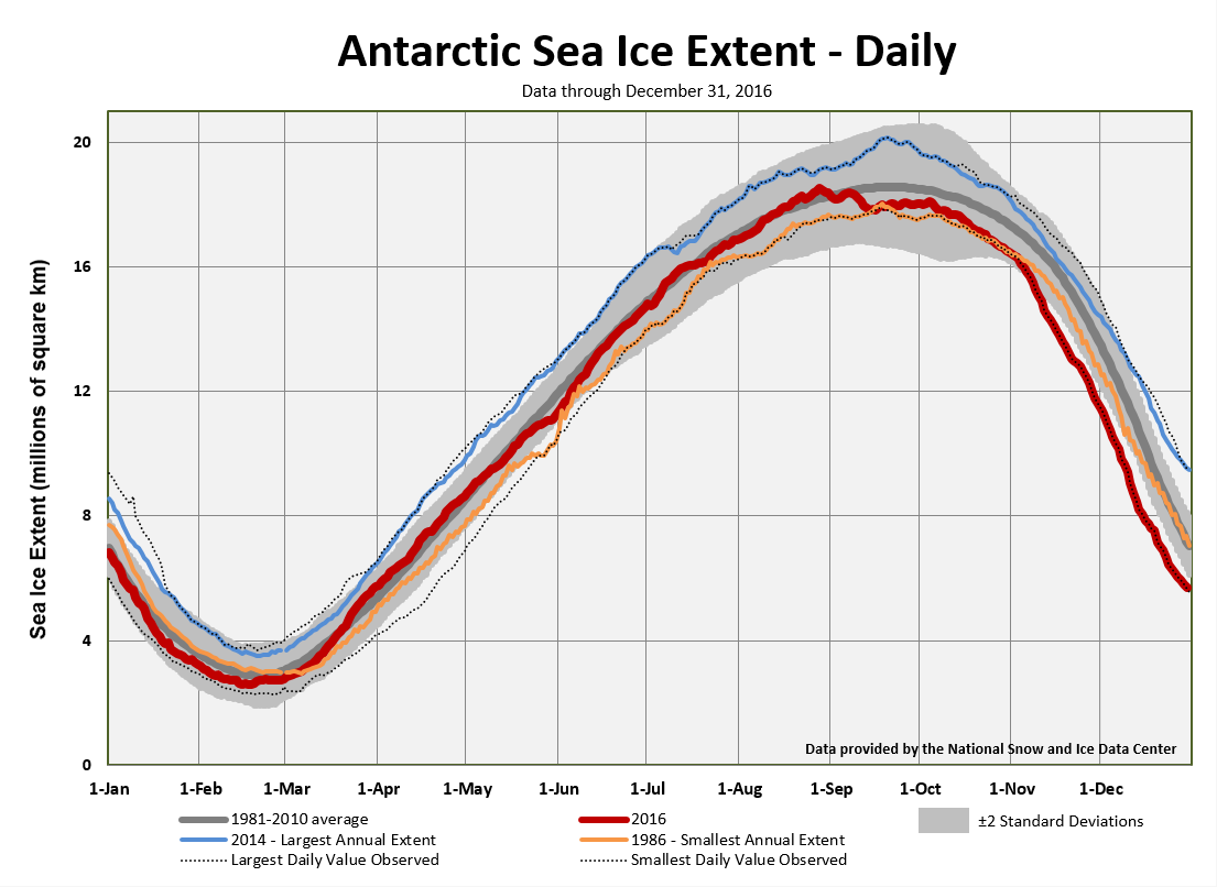
On February 19th the sea ice extent in the Southern Hemisphere reached its annual minimum extent at 2.6 million square kilometers (1.0 million square miles). This was the ninth lowest Antarctic sea ice minimum extent in the satellite record. The annual minimum extent has varied greatly over the past few years, approaching record low levels in 2011 and record high levels in 2013.
On August 31st, the Antarctic sea ice reached its maximum extent at 18.44 million square km (7.12 million square miles). This was the earliest occurrence of the maximum extent since satellite records began in 1979. This was the 10th smallest maximum extent for the Antarctic with sea ice 240,000 square km (93,000 square miles) larger than the average extent for the date. After the maximum extent occurred in late August, sea ice shrank early in September with the extent remaining nearly constant throughout the rest of the month.
For further information on the Northern and Southern Hemisphere snow and ice conditions, please visit the NSIDC News page.