NH Snow Cover Extent
Data were provided by the Global Snow Laboratory, Rutgers University. Period of record is 1966-2012 (46 years).
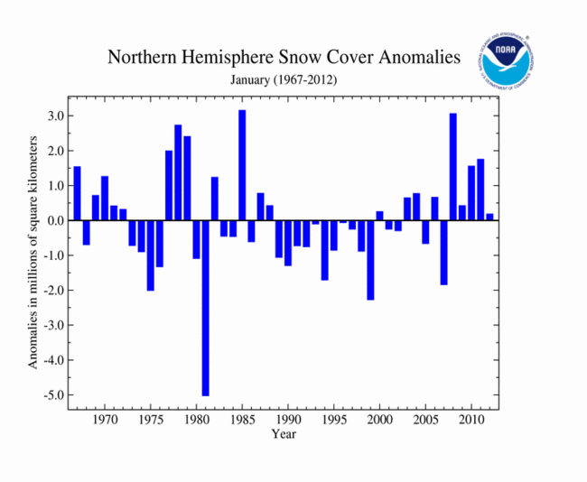
The Northern Hemisphere snow cover extent during January 2012 was slightly above average, and ranked as the 21st largest (26th smallest) January snow cover extent in the 46-year period of record. The monthly snow cover extent of 46.9 million square km (18.1 million square miles) was 185,000 square km (71,400 square miles) above average. Despite the snow cover extent being above average, January 2012 marked the smallest January snow cover extent since 2007. There was significant variability between continents, with Eurasia having above-average snow cover, and North America below-average snow cover.

During January, the North American snow cover extent was much below average, ranking as the 3rd smallest January snow cover extent on record. Only January 2006 and 1981 had smaller snow cover extents for the continent. The monthly snow cover extent was 16.1 million square km (6.2 million square miles), which is 1.4 million square km (540,500 square miles) below average. During the month, the contiguous U.S. and southern Canada were drier and warmer than average, which limited snow across those regions.

Eurasian snow cover extent was 30.3 million square km (11.7 million square miles) during January, which is 1.1 million square km (424,700 square miles) above average, ranking as the 9th largest January snow cover extent on record for the continent. This was the 5th consecutive January with above-average snow cover for Eurasia, and the largest since January 2008. Above-average snow cover was observed across central and eastern Europe, central Asia, and central and western China. Above-average snow cover was also observed across parts of North Africa, which is not part of the Eurasian continent. Below-average snow cover was present across parts of Iran and eastern China.
Sea Ice Extent

According to the National Snow and Ice Data Center (NSIDC), the Northern Hemisphere sea ice extent — which is measured from passive microwave instruments onboard NOAA satellites — averaged for January 2012 was 13.73 million square km (5.3 million square miles). This was 7.5 percent below the 1979-2000 average and ranked as the 4th smallest January Arctic sea ice extent on record. January 2012 is the 19th consecutive January and 128th consecutive month with below-average Arctic sea ice extent. January Arctic sea ice extent has decreased at an average rate of 3.3 percent per decade.
According to analysis from the NSIDC, sea ice was below average on the Atlantic side of the Arctic, especially in the Berants Sea. Conversely, on the Pacific side of the Arctic, much-above-average ice was observed for the Bering Sea, which had its second-highest amount of ice for January in the satellite record. The above-average ice extent across the Bering compensated somewhat for the below-average ice on the Atlantic side, but the overall ice extent was far below average.
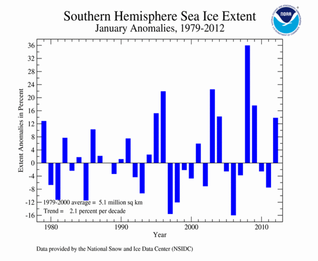
The January 2012 Southern Hemisphere sea ice extent was 13.8 percent above average — the 9th largest January extent on record. Throughout the entire month, which is part of the annual melt season for the Antarctic, sea ice trended much above-average. Southern Hemisphere January sea ice extent has increased at an average rate of 2.1 percent per decade, with significant inter-annual variability.
For further information on the Northern and Southern Hemisphere snow and ice conditions, please visit the NSIDC News page.