NH Snow Cover Extent
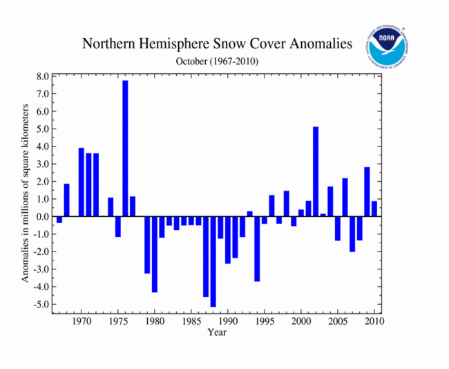
October marks the beginning of the cold season for the Northern Hemisphere and storms begin bringing snow to the higher latitudes and elevations. During October 2010, the Northern Hemisphere snow cover extent was 331,275 square miles (858,000 square km) above the long–term average of 6.9 million square miles (17.9 million square km). The monthly value ranks as the 15th largest October snow cover extent in the 43–year period of record.
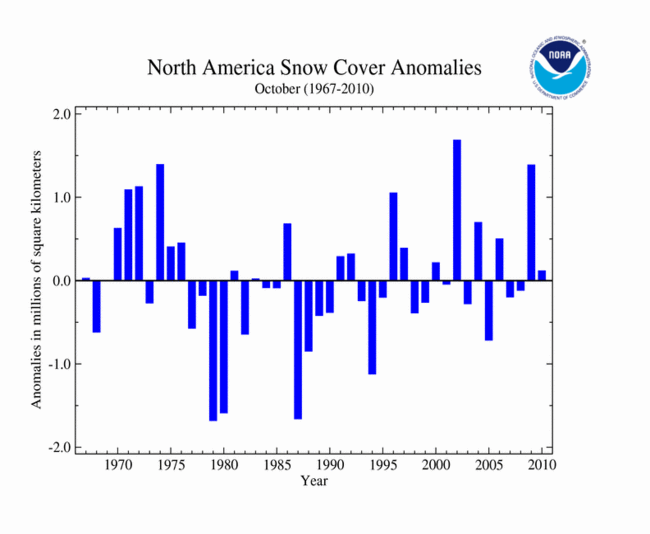
Across North America, snow cover extent for October 2010 was slightly above average. Canada and Greenland had above average snowfall, while Alaska and the contiguous U.S. had below average snowfall. The North American snow cover extent was 45,175 square miles (117,000 square km) above the long term average of 3.1 million square miles (8.1 million square km). This ranks the North American snow cover extent as the 17th largest October extent (26th smallest) since the satellite record began in 1967. For more information on the U.S. October 2010 snow events, please visit the U.S. October Snow/Ice Summary page.
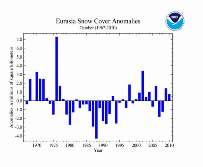
Eurasian snow cover extent was also above average for October 2010 with an areal extent of 4.1 million square miles (10.6 million square km), 286,100 square miles (741,000 square km) above average. This ranks as the 13th largest October snow cover extent on record.
Data were provided by the Global Snow Laboratory, Rutgers University.
Sea Ice Extent
Did You Know?
Expand "Arctic Sea Ice Measurements"
Arctic Sea Ice Measurements
Arctic sea ice extent is virtually impossible to accurately measure from the Earth's surface. The edges of the ice are ever changing and the sheer size of the ice mass (averaging two and half times the size of Canada) makes it difficult to measure directly on short time scales. To overcome the shortcomings of in situ observations, polar orbiting satellites began collecting data over the Arctic (as well as the Antarctic) in the 1970s. Scientists use radiometry data and visible imagery collected from the satellites to determine the sea ice extent. Each technique has its advantages and disadvantages, and more information can be found through the National Snow and Ice Data Center. Today a suite of NASA, NOAA, and Department of Defense satellites provide the data which is needed to accurately monitor sea ice extent on a daily, monthly, and annual basis.
The transition from ice–covered to ice–free ocean can occur over a large distance. When measuring the Arctic Sea ice extent from satellites, a threshold of minimum ice concentration is defined to mark where the ice sheet ends. NOAA uses a threshold of 15 percent ice concentration over an areal extent, because it provides the most consistent agreement between satellite and ground observations. At this low ice concentration, ocean waters are generally navigable by ships, one of the earliest motivations for better understanding changes in Arctic ice.
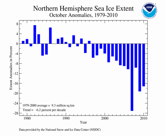
According to the National Snow and Ice Data Center (NSIDC), the Northern Hemisphere sea ice extent — which is measured from passive microwave instruments onboard NOAA satellites — averaged for October 2010, was 2.97 million square miles (7.69 million square km). The monthly extent was 17.2 percent below the 1979–2000 average and ranked as the third smallest October Northern Hemisphere sea ice extent in the satellite record, behind 2007 (smallest) and 2009 (second smallest). Northern Hemisphere October sea ice has declined at a rate of 6.2 percent per decade. The anomalously low extent for the month was partially driven by the third lowest annual minimum occurring one month before in September and above–average temperatures across the Arctic during October. It was the 14th consecutive October with below–average Northern Hemisphere sea ice.
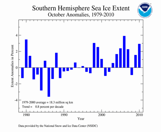
Conversely, the October Southern Hemisphere sea ice extent was 2.9 percent above the long-term average at 7.2 million square miles (18.7 million square km). The monthly extent marks the fourth largest October Southern Hemisphere sea ice extent since the satellite record began in 1979, and it was the eighth time since 2000 the Southern Hemisphere sea ice extent was above average during October.
For further information on the Northern and Southern Hemisphere snow and ice conditions, please visit the NSIDC News page, provided by NOAA's National Snow and Ice Data Center (NSIDC).