
Updated: 7 March 2011
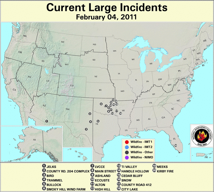
February is not typically considered part of the U.S. wildfire season, with fire activity typically being low during the month. However, dry and warm conditions across the southern and southeastern U.S., particularly the second half of the month, were associated with an early start to the 2011 wildfire season. Please see the monthly temperature and precipitation discussion for more information. The number of new wildfires and the acreage burned during the month were much-above average. The 8,226 new wildfires that occurred during February 2011, marked the highest February wildfire count on record, and the 187,021 acres (75,685 hectares) was the second most February acreage burned, behind February 2008 when 214,183 acres (86,677 hectares) burned. Wildfire records for the U.S. date back to 2000. On February 4th, there were 20 large wildfires burning across the U.S. — ten in Oklahoma, four each in Arkansas and Texas, and one each in Arizona and Florida. By the middle of the month, large wildfire activity shifted more eastward, with 16 large wildfires burning nationally — six in Missouri, two each in Alabama, Florida, North Carolina, Virginia, and one in both Texas and Georgia. By the end of the month, wildfire activity was concentrated in the Southern Plains and the Florida Peninsula. On the 28th, there were 25 large fires burning in the U.S., 18 in Texas, five in Florida, and one each in New Mexico, and Virginia.
[ February 4
 |
February 23
|
February 23 |
February 28
|
February 28 ]
]
Note: Unless conditions warrant it, the U.S. Forest Service updates out of season large fire maps once per week on Fridays.
2011 Wildfire Statistics
(Source: NIFC)| Year–To–Date Totals as of February 28th | Nationwide Number of Fires | Nationwide Number of Acres Burned |
|---|---|---|
| 02/28/2011 | 9,752 | 204,373 |
| 02/28/2010 | 2,302 | 34,543 |
| 02/28/2009 | 7,976 | 177,597 |
| 02/28/2008 | 5,829 | 254,987 |
| 02/28/2007 | 4,178 | 35,351 |
| 02/28/2006 | 5,936 | 411,011 |
| 02/28/2005 | 4,192 | 28,149 |
| 02/28/2004 | 4,587 | 55,173 |
| 02/28/2003 | 3,994 | 49,695 |
| 02/28/2002 | 6,032 | 65,566 |
| 02/28/2001 | 7,792 | 163,206 |
| 02/28/2000 | 8,467 | 208,967 |
| 5–yr average (2006 – 2010) |
5,244 | 182,698 |
| 10–yr average (2001 – 2010) |
5,571 | 134,931 |
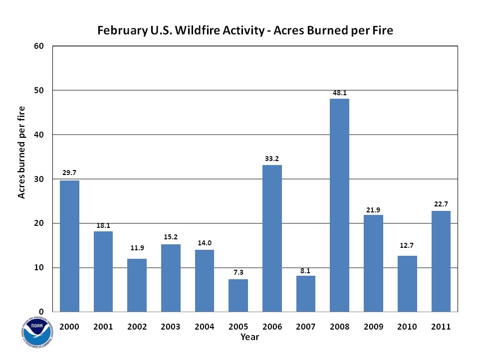
According to statistics from the National Interagency Fire Center (NIFC), at the end of February, the nationwide number of fires year-to-date was 9,752, which burned 204,373 acres (82,707 hectares), with an average of 21.0 acres (8.5 hectares) per fire. This marks the largest number of fires for the year-to-date period and the fourth largest acreage burned since records began in 2000. During February, an estimated 187,021 acres (75,684 hectares) burned across the U.S., which is more than twice the 2000-2010 average. A total of 8,226 fires were reported during the month, which is also more than two times the average. The average number of acres burned per fire was 22.7 acres (9.2 hectares), which was also above average.

According to the U.S. Drought Monitor the overall size of the drought footprint changed little during February, but many locations that were experiencing drought at the beginning of the month experienced worsening drought conditions during February. By March 1st, most of the West continued to be drought free, with the exception of parts of the Southwest. Across southern New Mexico, Arizona, and western Texas, drought conditions worsened from moderate to severe drought during the month. Severe drought also expanded across the Front Range in Colorado and across central Oklahoma. Severe and extreme drought conditions expanded across most of Texas, and the footprint of extreme drought grew across the Lower Mississippi River Valley. Moderate drought conditions developed across northern Alabama and Mississippi and severe drought covered much of the Carolina piedmont. The overall size of the extreme drought in Florida shrank, but moderate-to-severe drought continued to plague most of the state on March 1st. Across Hawaii, precipitation amounts were mixed, the overall size of the extreme drought footprint shrank, but moderate drought developed over much of the Big Island. In Alaska, abnormally dry conditions expanded into central parts of the state.

As stated above, wildfire activity across the Southern Plains of the U.S. was extremely high during February, particularly across parts of Texas. Seventy one individual wildfires broke out across Texas on the weekend of February 25th, burning nearly 137,700 acres (55,725 hectares) according to the Texas Forest Service. The acreage burned in Texas accounted for nearly three-quarters of all acres burned nationwide during February. The wildfires were driven by warm, dry, and windy conditions. On the 27th, the temperature in Laredo, Texas reached 103°F (39.4°C), which was the first 100°F reading for the year for any location in the U.S., and it broke a daily record for the city. Several fires reached over 20,000 acres (8,094 hectares) in size, particularly in Potter, Motley, and Andrews counties. Interstate Highway 20 was shut down for several hours on the 27th after heavy smoke from the fires limited visibility. An automobile accident caused by the smoke left one dead. Across the state, 60 homes were destroyed over the weekend. The weather conditions improved on the 28th when moisture and calm winds returned to the region.
A large wildfire in western Virginia took 10 days to fully contain, and burned nearly 3,500 acres (1,416 hectares), 10 miles west of Harrisonburg in the George Washington National Forest. The fire burned between the 18th and 28th. Several roads were forced to close due to the fire and the associated smoke, including U.S. Highway 33. Several miles east of Harrisonburg, in the Shenandoah National Park, another fire burned 1,800 acres (728 hectares) during the same period — the most acres burned in the national park in over 100 years. Both fires were contained by March 1st, after beneficial rains came to the region, aiding firefighters. No personal property was lost in the fires, although over 300 homes were threatened.
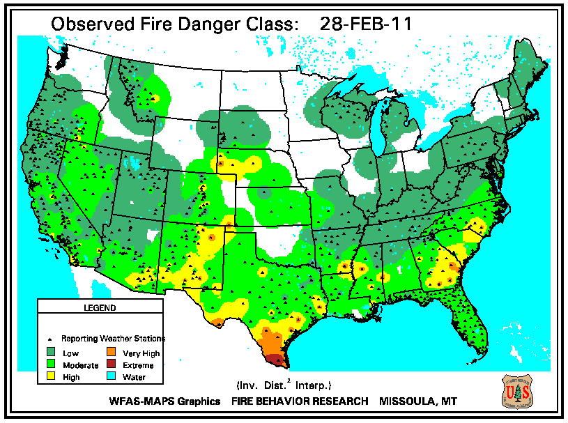
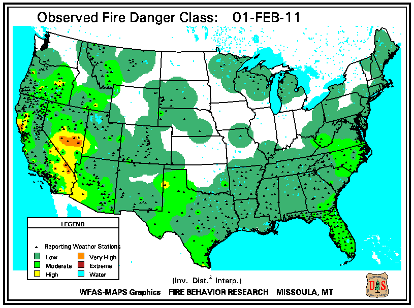
According to the U.S. Forest Service (USFS) – Wildland Fire Assessment System, on February 1st, high fire danger was confined to the Great Basin and the Southwest. By the 15th, high fire danger expanded into the Southern Plains and the along Eastern Seaboard. High fire danger was reported across the Great Basin, the Southwest, the central Plains, and the East Coast from Georgia into New Jersey. Precipitation the last week of the month quieted the fire danger across parts of the West, but high fire danger continued in New Mexico, southern Texas, and along the Southeast coast, where dry conditions persisted.
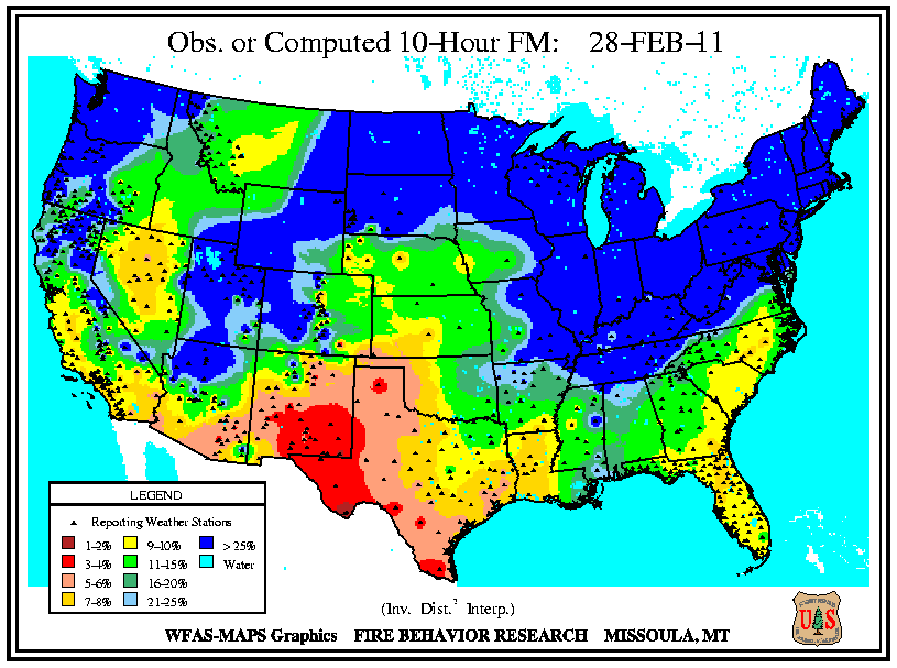
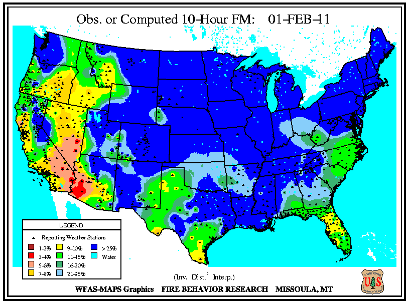
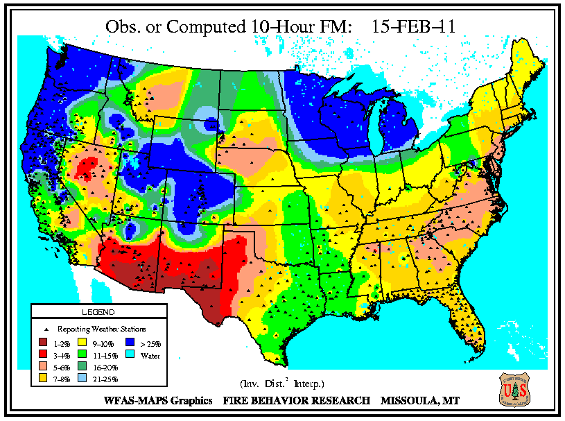
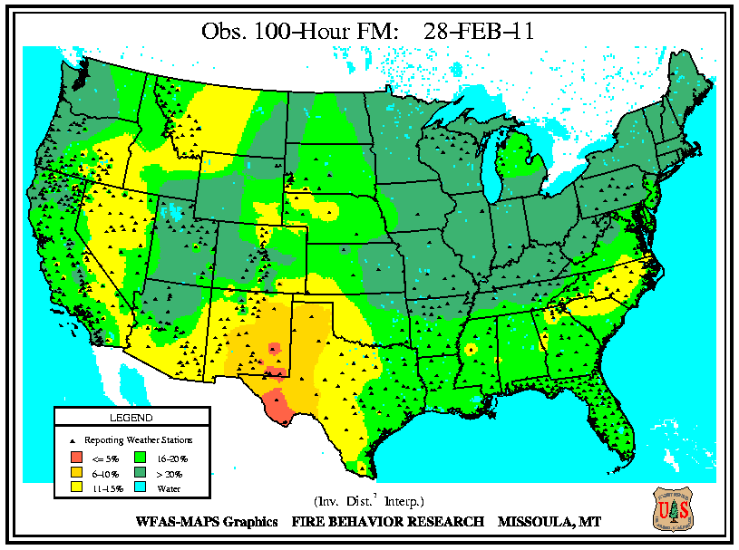
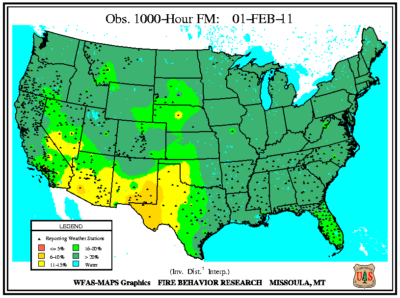
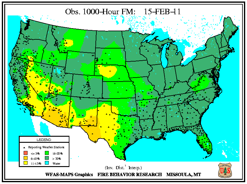
According to the U.S. Forest Service (USFS) – Wildland Fire Assessment System, at the beginning of February, low fuel moistures of all sizes were present in the West, with the exception of the Pacific Northwest and the Sierra Nevada Mountains. Dry larger fuels (100-hour and 1,000-hour fuel moistures) extended eastward into New Mexico, Oklahoma, and Texas. Dry conditions the first half of the month for most of the country caused a large expansion of low 10-hour fuel moistures by the 15th. Low 10-hour fuel moistures were present in all locations of the U.S., except the Pacific Northwest, the central Rockies, and the western Great Lakes. The lowest 10-hour fuel moistures were present across the Great Basin, the Southwest, and the Mid-Atlantic. Low 100-hour fuel moistures were also widespread across the southern two-thirds of the country, except for the central Rockies and the Gulf Coast. Dry large fuels (1,000-hour fuel moistures) were confined to the Southwest. By the end of the month, an active storm pattern in the West, Northern Plains, Great Lakes, and Northeast moistened 10-hour and 100-hour fuel moistures there. Low 10-hour and 100-hour fuel moistures were reported in the Florida Peninsula, western Texas, and southern New Mexico. The only low 1,000-hour fuel moistures across the U.S. continued in the Southwest.
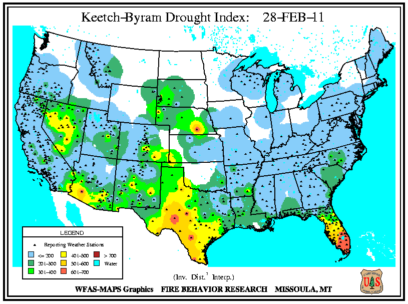
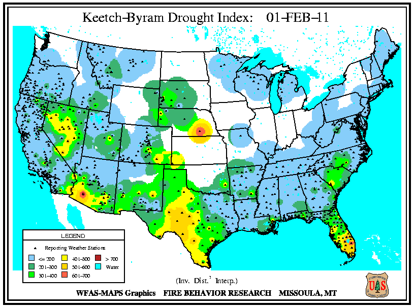
According to the U.S. Forest Service (USFS) – Wildland Fire Assessment System, at the beginning of the month, high Keetch–Byram Drought Index (KBDI) values were reported across southern Florida, most of Texas, central Nevada, and southern Arizona. The KBDI remained generally unchanged by the 15th. On the 28th, the high KBDI values across southern Florida expanded into northern portions of the peninsula, and in Texas the high KBDI values expanded and increased in the western regions of the state.