Updated: 6 December 2010

*Data are for the period October 29th–November 26th, and are from the National Interagency Fire Center.
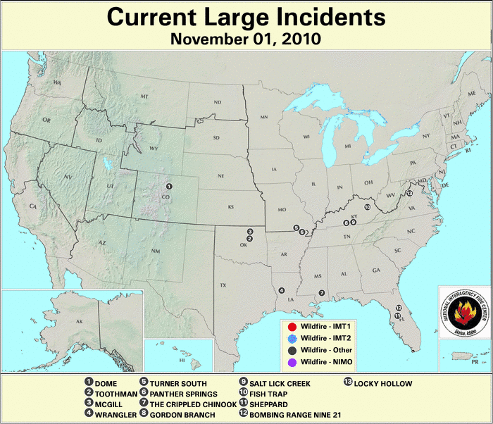
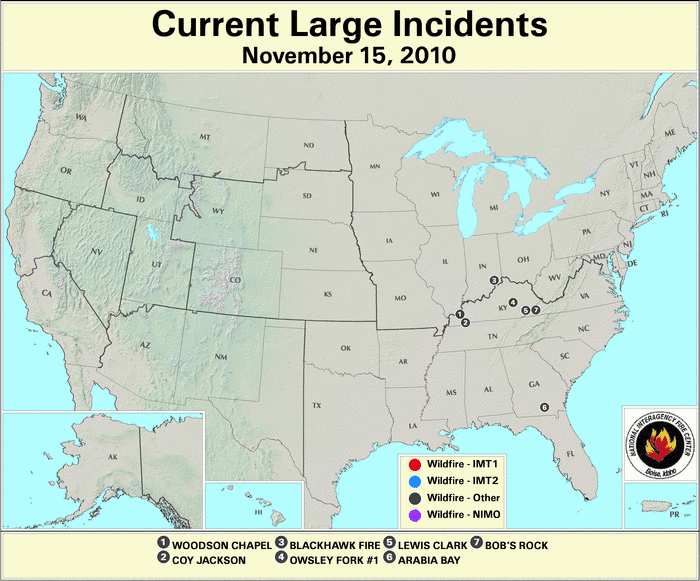

During the 2010 year–to–date period, 66,013 fires have burned 3.31 million acres across the U.S., which is the lowest year–to–date acreage burned in the last decade. November historically tends to be a relatively inactive fire month, and November 2010 was no exception. Weather conditions, when averaged across the U.S. for the month, indicated that precipitation amounts and temperatures were near normal. The western states tended to be cooler and drier than normal, while the Midwest tended to be wetter and warmer than normal. See the national temperature and precipitation State of the Climate report for additional information on temperatures and precipitation. On November 1st, there were 13 large wildfires burning across the U.S., three in Kentucky; two in Missouri, Oklahoma, and Florida; and one each in Virginia, Colorado, Louisiana, and Mississippi. By the 15th, large wildfire activity was confined to the driest parts of the country — the Ohio River Valley and the Southeast. Four fires were burning in Kentucky, and one was burning in Indiana, Virginia, and Georgia. By the end of the month, wetness in the eastern half of the country helped quiet wildfire activity. Only one large wildfire was burning nationwide — in Oklahoma.
2010 Wildfire Statistics
(Source: NIFC)| Year–To–Date Totals as of November 26th | Nationwide Number of Fires | Nationwide Number of Acres Burned |
|---|---|---|
| 11/26/2010 | 66,013 | 3,305,227 |
| 11/26/2009 | 77,044 | 5,835,801 |
| 11/26/2008 | 75,786 | 5,131,089 |
| 11/26/2007 | 79,129 | 8,900,885 |
| 11/26/2006 | 89,792 | 9,508,251 |
| 11/26/2005 | 60,678 | 8,433,600 |
| 11/26/2004 | 64,220 | 8,063,941 |
| 11/26/2003 | 57,637 | 3,815,952 |
| 11/26/2002 | 71,342 | 7,117,812 |
| 11/26/2001 | 79,513 | 3,355,138 |
| 11/26/2000 | 91,094 | 7,309,887 |
| 5–yr average (2005 – 2009) |
76,486 | 7,656,854 |
| 10–yr average (2000 – 2009) |
74,624 | 6,794,700 |
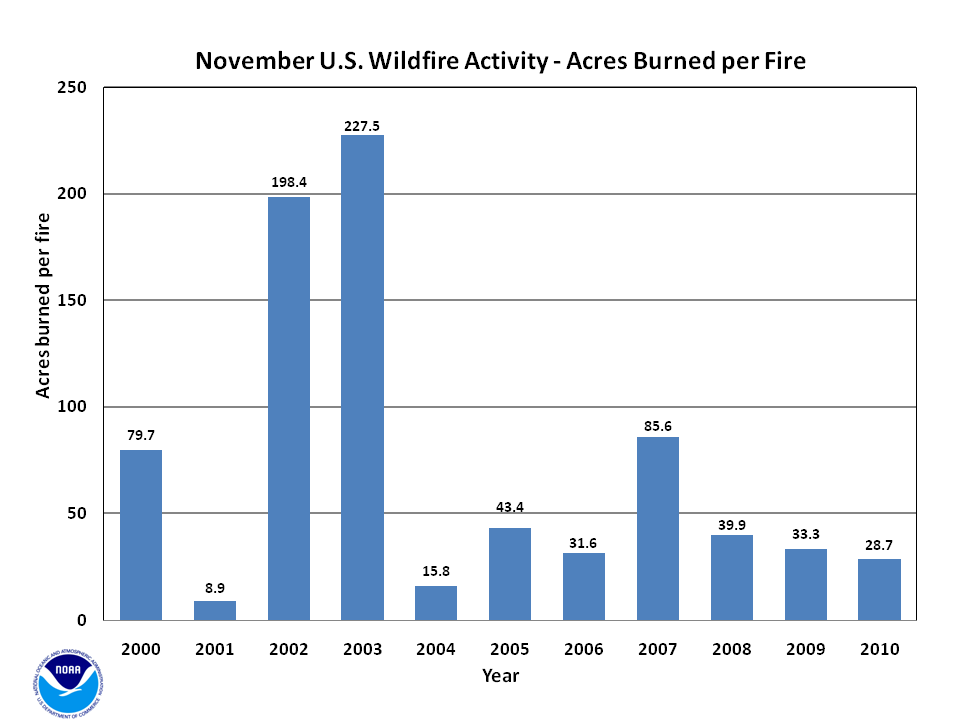
According to statistics from the National Interagency Fire Center (NIFC), at the end of November, the nationwide number of fires year–to–date was 66,013 which burned 3.31 million acres (1.3 million hectares), with an average of 50.1 acres (20.3 hectares) per fire. During November, an estimated 122,728 acres (49,667 hectares) burned across the U.S., which is 39 percent below the 2000–2009 average. A total of 4,277 new fires were reported during the month, which is 9 percent above the 2000–2009 average. The average number of acres burned per fire was 28.7 acres (11.6 hectares) during November, which is 38 percent (less than half) of the ten-year mean.

According to the U.S. Drought Monitor, the overall size of the drought footprint increased little during November 2010, while some areas experienced drought improvement and others experienced deteriorating conditions. Drought conditions generally improved one to two categories across the Ohio River Valley where numerous storm systems dropped several inches of rain during the month. Drought worsened for most of Florida during November, where very little to no precipitation fell. Nearly the entire state was experiencing drought conditions by the end of the month. Drought also worsened for south Texas and parts of southeast Colorado by two to three categories. Across the rest of the contiguous U.S., drought conditions did not change much. The ongoing drought conditions across Hawaii improved during November; at the end of the month only 49 percent of the state was experiencing drought, compared to 72 percent at the end of October.

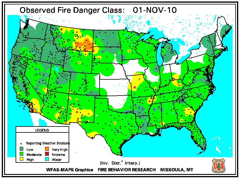
According to the U.S. Forest Service (USFS) Wildland Fire Assessment System, on November 1st, high fire danger was present across areas of the Ohio and mid-Mississippi River Valleys, the northern Rockies, and the Southwest. By the middle of the month, the high fire danger lessened across the northern Rockies, where snowfall was widespread. High fire danger spread in dry areas including the Southeast, lower Mississippi River Valley, western Texas, and the Southwest. A storm system moving through the eastern half of the country during the last few days of the month lowered the fire danger across the Southeast. Dry conditions persisted across the central and southern Plains, where very high fire danger was observed. The high fire danger in the Southwest persisted through the end of November.
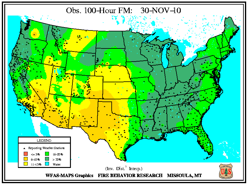
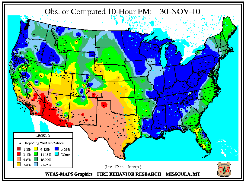
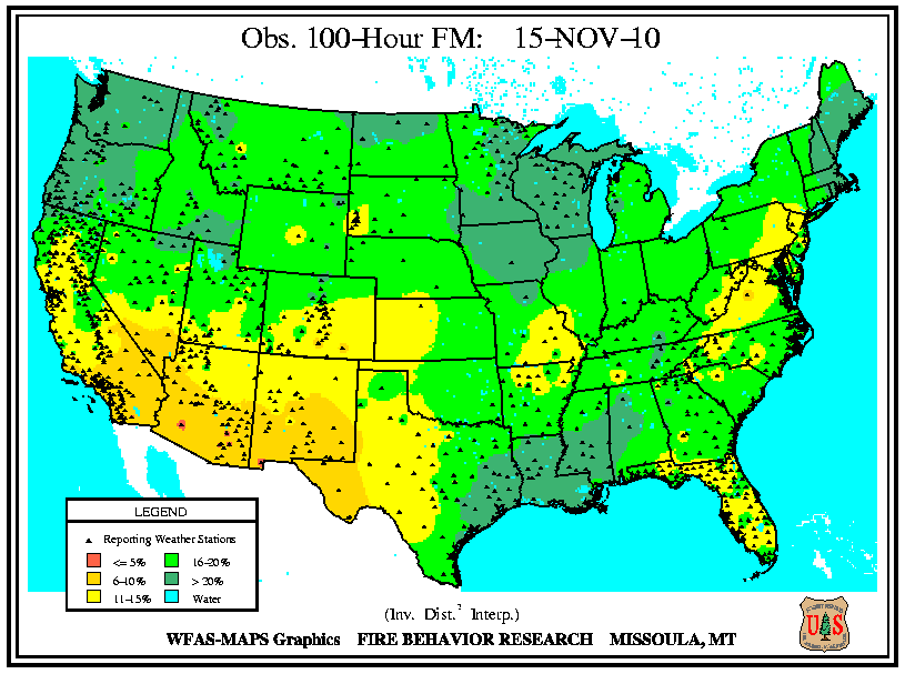
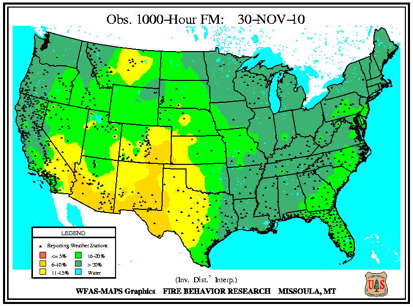
According to the USFS Wildland Fire Assessment System, at the beginning of the month, 10-hour and 100-hour fuel moistures were low across a large portion of the country stretching from the Southwest, into the Rockies, across the central and southern Plains, and into the Ohio River Valley. The largest fuels (1,000-hour fuel moistures) were dry across the mid-Mississippi River Valley, the High Plains, and the Southwest. Precipitation across the interior Southeast and lower Mississippi River Valley increased 10-hour and 100-hour fuel moistures by November 15th. While low 10-hour and 100-hour fuel moistures persisted for the mid-Mississippi River Valley and the Southwest. Low 1,000-hour fuel moistures were present across the Southwest and High Plains of Colorado and New Mexico. By the end of the month, precipitation across the eastern and northern regions of the country increased fuel moistures of all sizes there. The only dry fuel moistures were present in the Southwest.

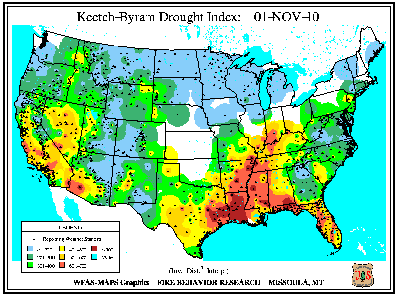
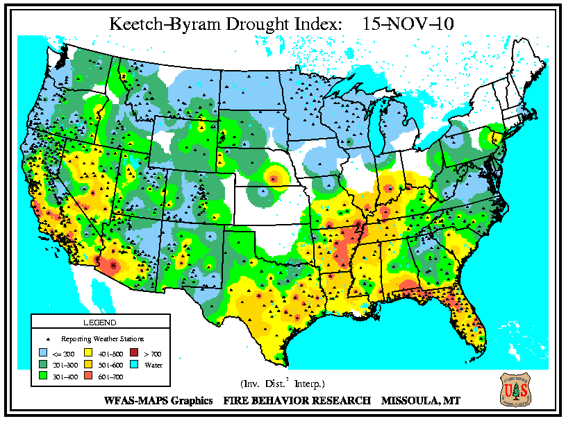
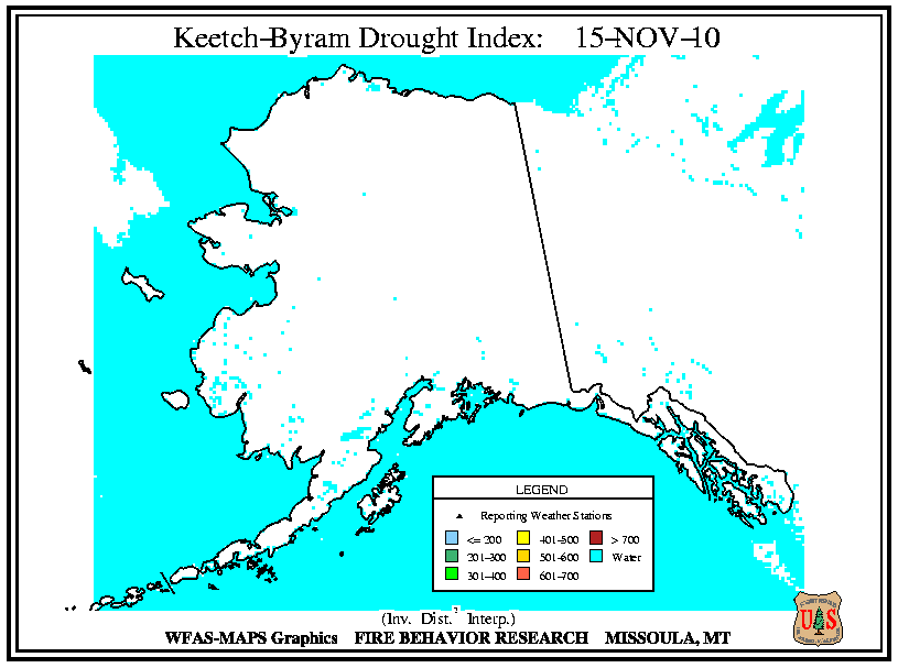
According to the USFS Wildland Fire Assessment System, at the beginning of the month, high Keetch–Byram Drought Index (KBDI) values were consistent with regions experiencing drought. By November 1st, the highest KBDI values were observed across the lower Mississippi River Valley, the Gulf Coast, the Ohio River Valley, and the Southwest. By the 15th, conditions improved for Louisiana and Mississippi, while high KBDI values persisted for the Ohio River Valley, the eastern Gulf Coast, and the Southwest. On November 30th, conditions improved across most of the central and eastern parts of the United States, while they worsened in Florida and Texas. Conditions also worsened for the Great Basin and the Southwest.