

Updated: 3 February 2010
January is not considered to be part of the U.S. wildfire season, with fire activity typically being slow during the month. January 2010 was below average in terms of number of fires, acres burned, and acres burned per fire. At the beginning of the month, there were no large fire instances anywhere in the United States. By mid-January, there were three large fires in the Southwest, one in California and two in Arizona. The end of 2009 and the first two weeks of 2010 were dry for the region, with relatively low fuel moistures. Significant precipitation fell across the Southwest between the 17th and 23rd, increasing fuel moistures and eliminating any large fire footprints by the end of the month — see the monthly temperature and precipitation discussion. On the 29th, the only large fire incident was in southwestern Florida where moderately low 10-hour fuel moistures were reported. Eight large fires were contained during the month.
[ January 1
 |
January 15
|
January 15 |
January 22
|
January 22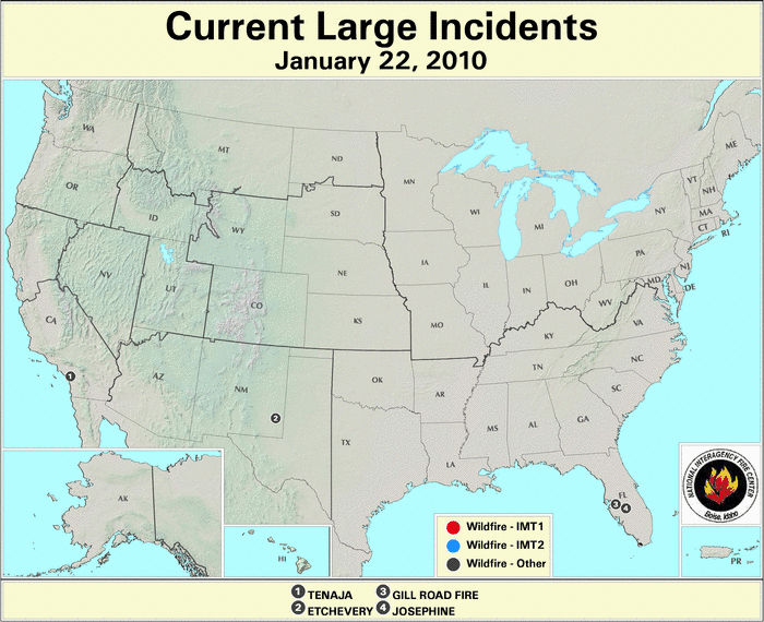 |
January 29
|
January 29 ]
]
Note: Unless conditions warrant it, the U.S. Forest Service updates out of season large fire maps once per week on Fridays.
2010 Wildfire Statistics
(Source: NIFC)| Year–To–Date Totals as of January 29th | Nationwide Number of Fires | Nationwide Number of Acres Burned |
|---|---|---|
| 01/29/2010 | 1,081 | 19,052 |
| 01/29/2009 | 2,481 | 57,150 |
| 01/29/2008 | 1,380 | 40,804 |
| 01/29/2007 | 387 | 4,597 |
| 01/29/2006 | 3,166 | 322,197 |
| 01/29/2005 | 1,740 | 15,386 |
| 01/29/2004 | 1,964 | 18,818 |
| 01/29/2003 | 1,120 | 10,721 |
| 01/29/2002 | 1,383 | 10,079 |
| 01/29/2001 | 1,231 | 44,334 |
| 01/29/2000 | 2,796 | 40,757 |
| 5–yr average (2005 – 2009) |
1,831 | 88,207 |
| 10–yr average (2000 – 2009) |
2,005 | 56,574 |
According to statistics from the National Interagency Fire Center (NIFC), between January 1st and January 29th, approximately 19,052 acres (7,710 hectares) were burned across the United States, which is 37,522 acres (15,185 hectares) below the 2000–2009 average of 56,574 acres (22,895 hectares). A total of 1,081 new wildfires were reported for the month, which is 684 fires below the 2000–2009 average of 1,765. This ranks January 2010 as the second slowest month in terms of number of fires and sixth slowest (out of 11 years) month for acres burned since 2000. The average acreage burned per fire was 17.6 acres (7.1 hectares) per fire, which is 7.8 acres (3.2 hectares) below the 2000–2009 average of 25.4 acres (10.3 hectares).

The U.S. Drought Monitor indicated that drought conditions generally improved across the U.S. during the month of January. Precipitation in the Southwest improved drought conditions 1-2 categories over a large area. At the end of the month, extreme drought covered 0.13 percent of the country, and was confined to northern Arizona and the Hawaiian Islands. Small pockets of severe drought, amounting to 1.27 percent of the country, persisted in central Washington, northern California, Nevada, northern Arizona, northern Wisconsin, southern Texas, and Hawaii. The eastern third of the country remained generally drought free, as cool and wet conditions have persisted for the past several months.

According to the U.S. Forest Service (USFS) – Wildland Fire Assessment System, at the beginning of the month, high fire danger was present across portions of southern California and western Texas. Moderate fire danger was more widespread, including southern California, northwestern Texas, the Ozark Mountains, and parts of the Southeast. Significant precipitation over most of the contiguous U.S. had eliminated any high fire danger by the end of the month. Moderate fire danger was present in southern Texas, the central Rockies, and parts of the Gulf Coast and Southwest.

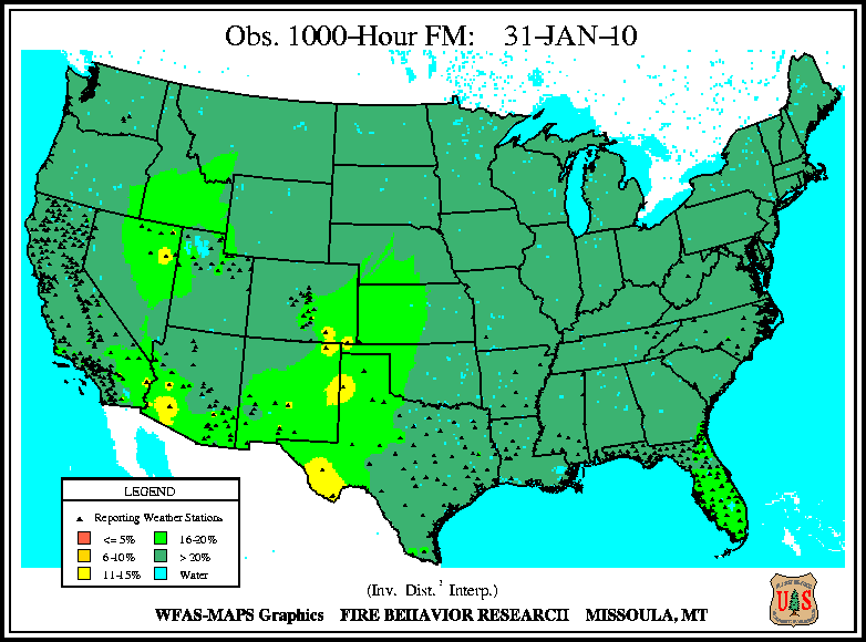
According to the U.S. Forest Service (USFS) – Wildland Fire Assessment System, at the beginning of 2010, low 10-hour fuel moistures were present across southern California, eastern New Mexico, and western Texas. Moderately dry small fuels stretched into western Nevada, southern Oklahoma, and parts of the Southeast. Low 100-hour and 1000-hour fuel moistures were present in generally the same locations as the low 10-hour fuel moistures. By the end of the month, the dry 10-hour fuel moistures in the Southwest shrank due to heavy precipitation during January, with the exception of dry small fuels extending into Arizona. A larger footprint of dry small fuels was also present across central Louisiana by the end of January. Low 100-hour and 1000-hour fuel moistures followed a similar pattern as the 10-hour levels at the end of the month.

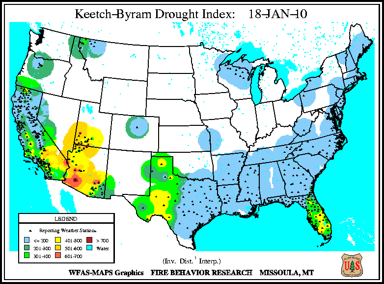
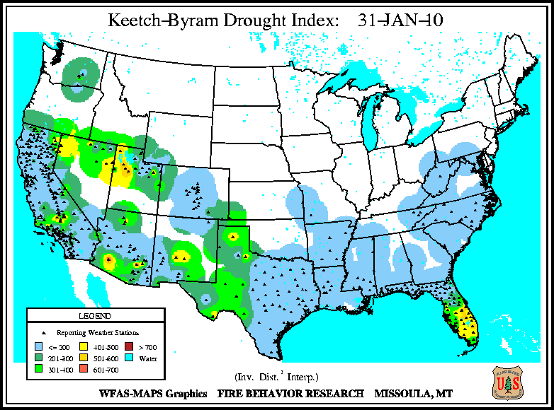
According to the U.S. Forest Service (USFS) – Wildland Fire Assessment System the Keetch–Byram Drought Index (KBDI), at the beginning of the month indicated continued dryness and thus fire risk across southern California, northern Arizona, southwest Utah, Nevada, western Texas, and central Florida. At the month's mid point, conditions worsened in western Arizona and parts of Southern California, while they improved in northern Utah and Nevada. By the end of the month, precipitation had lowered the fire risk across most of Arizona and Southern California, while conditions worsened in western Utah and southern Florida.