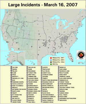
The beginning of the month saw large wildland fire activity in southern California, but as the month progressed, numerous wildland fires occurred in the Southeast. The areas of fire activity were in parts of the country experiencing drought and abnormally dry conditions. A satellite image depicts fires burning in the Southeast on 20 March.
From the beginning of 2007 until the beginning of April, there have been over 18,000 wildland fires across the Lower 48 States, and over 300,000 acres were burned, according to estimates from the National Interagency Fire center. More than 75 percent of the fires and acres burned so far this year have been in the Southern area (which encompasses 13 states, Puerto Rico, the Virgin Islands and the District of Columbia).
| Totals as of 9 April 2007 | Nationwide Number of Fires | Nationwide Number of Acres Burned |
|---|---|---|
| 4/9/2007 | 18,080 | 308,838 |
| 4/9/2006 | 24,004 | 1,944,835 |
| 4/9/2005 | 11,352 | 176,486 |
| 4/9/2004 | 18,189 | 231,773 |
| 4/9/2003 | 9,377 | 157,852 |
| 4/9/2002 | 17,470 | 283,647 |
| 4/9/2001 | 15,307 | 284,907 |
Dead fuel moisture levels were very dry in March. The 10–hour fuel moisture levels on 1 April were extremely dry throughout most of the Southwest.
Medium to larger fuels (i.e., the 1 April 100–hr and 1 April 1000–hr fuel moistures) were unusually dry over the past month in most of the western and eastern thirds of the country.
The Keetch–Byram Drought Index (KBDI), a widely used index for fire risk, had the largest potential for wildland fire activity in the contiguous U.S. in southern California, Montana and Wyoming. In addition, the observed experimental fire potential index was anomalously high in southern California and northern New England.
 NOAA's National Centers for Environmental Information
