ENSO WARM EVENT CONTINUES TO DEVELOP:
SSTs WARM ACROSS THE EQUATORIAL PACIFIC
SSTs WARM ACROSS THE EQUATORIAL PACIFIC
|
|
Sea-Surface Temperatures
(SSTs) and
Mixed-Layer Conditions: A large area of Sea-Surface Temperature (SST) anomalies greater than +0.5°C (+0.9°F) stretched from the central Pacific to the South American coast in September, with anomalies greater than +1.0°C (+1.8°F) between 120°W and the South American coast. Water temperatures in the mixed-layer also continued to warm over the past month, with a large area of +1.0°C (+1.8°F) and greater temperature anomalies as deep as 150 meters in the central and eastern Pacific. For the month of September, the SST anomaly in the Niño 3.4 Index region was +0.61°C (+1.1°F), which was an increase of +0.23°C (+0.41°F) compared to the August anomaly. The SSTs in the Niño 4 Index region of the western equatorial Pacific also continued to warm during September, resulting in a monthly anomaly of 0.73°C (1.31°F) above the mean (map of Niño regions). For the most recent global ocean surface temperatures, please see the loop of satellite-derived weekly SST anomalies for September 2006. With warmer SSTs in the Niño 3.4 index region in September, the 3-month running mean in this region was above average for the third month in a row, but remained below the +0.5°C (+0.9°F) threshold that would indicate the onset of an El Niño episode (NOTE: For NOAA's official ENSO classification scheme, please see NOAA's El Niño/La Niña Index Definition). The Climate Prediction Center's most recent ENSO Diagnostic Discussion indicated that a warm event (El Niño) had developed by early September, but the future strength of the event remains uncertain at this time. The ENSO forecast from the Australian Bureau of Meteorology (BoM) remains somewhat more conservative for the evolution of the current conditions (see the Australian BoM ENSO Wrap-Up). |


|
|
Equatorial Zonal
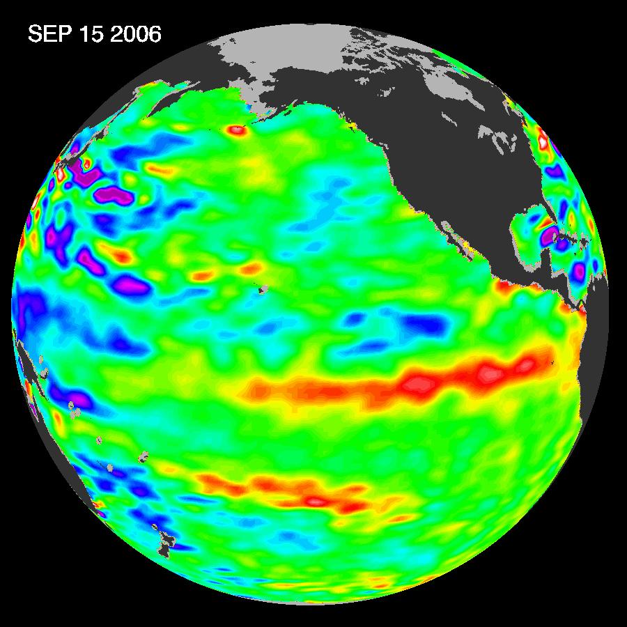
Winds (U-Component Winds) and Sea-Level Topography: The easterly Trade winds were stronger-than-normal across much of the eastern and central equatorial Pacific during September, while anomalous westerly winds were observed in the western Pacific. Significant week-to-week variability in the near-surface winds has been observed along the equatorial region of the Pacific over the past month, as shown in the loop of September zonal winds. A period of westerly flow in the equatorial region during early September gave way to stronger than normal easterly Trade winds later in the month. Pacific sea levels measured by the NASA/JPL Jason-1 satellite were above average in the central and eastern tropical Pacific in September, reflecting the warmer-than-average ocean temperatures and the developing El Niño event (see the 15 September 2006 sea level anomalies image to the left). |

|
|
Outgoing
Longwave Radiation (OLR): The map to the left shows the spatial pattern of global OLR (in W m-2) observed by satellite during September. The absence of strong positive or negative OLR anomalies (typically associated with La Niña and El Niño, respectively) is indicative of neutral ENSO conditions. At present, the lack of any large-scale atmospheric signal suggests that the atmosphere has lagged the ocean during the formative phase of the current El Niño event. The monthly OLR index for September was -0.2 W m-2 averaged across an area in the western Pacific between 160° E and 160° W. This was the second consecutive month that the index was below the long-term mean. At present, NOAA's Climate Prediction Center has forecasted the current El Niño episode to persist through the end of 2006. Therefore, it is expected that the OLR Index will decrease further as the Walker Circulation shifts to the east and tropical convection in the central and eastern equatorial Pacific intensifies. Note that high frequency variability in OLR is typically associated with the Madden-Julian Oscillation (MJO, which is convective activity that propagates west to east in the near-equatorial region from the Indian Ocean into the Pacific Ocean approximately every 30-60 days). The latest MJO activity can be seen in CPC's graphs of Daily MJO Indices. |
 Larger image of
September OLR
Larger image of
September OLR Larger image of
September OLR Index
Larger image of
September OLR Index| Southern
Oscillation Index (SOI): The standardized SOI was negative in September, with an averaged value of -0.7 for the month. Therefore, September was the fifth consecutive month with a below average SOI. Note that consistently negative (positive) values of the SOI are typical of El Niño (La Niña) conditions, and persistence of negative SOI values will likely occur as the current El Niño episode develops over the next few months. |

Additional Links
- ENSO Monitoring
- NOAA El Niño / La Niña Index Definition
- NOAA's Pacific Marine Environmental Laboratory (PMEL):
- NOAA's Climate Prediction Center (CPC):
- NOAA's Physical Science Laboratory
- NASA/JPL Ocean Surface Topography from Space
- Australian Bureau of Meteorology (BoM) Climate Driver Update
- IRI - International Research Institute