|
Contents Of This Report: |

|
National Drought Overview
|
|
[top]
Detailed Drought Discussion
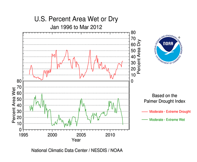
March 2012 was another warmer-than-average, but wetter-than-average, month (warmest on record and 25th wettest, based on data back to 1895) when weather conditions are averaged across the country. The March warmth is reflected in regional patterns of temperature anomalies at the monthly level as well as persistence of the warm anomalies at the weekly level (weeks 1, 2, 3, 4, 5). The pattern for precipitation was variable, both on a monthly basis as well as a weekly basis (weeks 1, 2, 3, 4, 5), although persistent dryness did occur over parts of the Southwest, Northern Plains, Southeast, and Northeast. Beneficial rainfall in the Southern Plains continued to shrink drought coverage with much of eastern Texas and eastern Oklahoma now drought-free. Winter storms brought beneficial rain and snow to parts of the West, especially northern regions, but did little to erase long-term deficits or replenish continued below-normal snow pack. Beneficial rains helped reduce drought coverage in Hawaii, but continued dryness expanded drought and abnormally dry areas in parts of the Northern Plains and Northeast. Nationally, the moderate-to-exceptional (D1-D4) drought footprint decreased slightly at about 31 percent of the country while the percentage in the abnormally dry category increased slightly to about 50 percent.
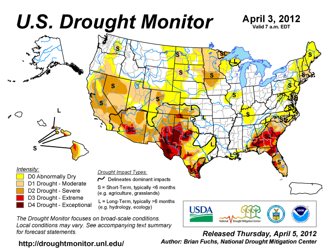
The U.S. Drought Monitor drought map valid April 3, 2012.
By the end of the month, the core drought areas in the U.S. included:
- a large area of moderate (D1) to exceptional (D4) drought across the Southwest to Southern and Central Plains;
- moderate to exceptional drought in the Southeast;
- areas of moderate to severe (D2) drought in the Upper Midwest to Northern Plains;
- expanding moderate drought across parts of the Northeast;
- expanding moderate to severe drought across much of the West; and
- parts of Hawaii, where moderate to extreme drought persisted.
Palmer Drought Index
The Palmer drought indices measure the balance between moisture demand (evapotranspiration driven by temperature) and moisture supply (precipitation). The Palmer Z Index depicts moisture conditions for the current month, while the Palmer Hydrological Drought Index (PHDI) and Palmer Drought Severity Index (PDSI) depict the current month's cumulative moisture conditions integrated over the last several months.
|
 |
As seen on the March 2012 Palmer Z Index map, low precipitation and warm temperatures (with the accompanying increased evapotranspiration) led to short-term drought across much of the Central Rockies to Northern Plains, Northeast, and parts of the Midwest and Southeast this month. Wet conditions are evident on the Z Index map across parts of the Southern Plains and Northwest. Compared with the February 2012 PHDI map, the March 2012 PHDI map indicates that drought conditions improved in parts of the Southern Plains and Northwest but intensified in parts of the Southeast, Southwest, and Upper Mississippi Valley, and wet conditions decreased across much of the Northern Plains and Northeast to Ohio Valley. The March 2012 PHDI map also reflects the long-term nature of the drought conditions. The Z Index and PHDI maps in combination show that precipitation brought relief to parts of the Southern Plains and Northwest drought areas, and moisture conditions further declined across the Northeast, Ohio Valley, and Northern Plains; but for much of the Southeast, Southwest, and Upper Mississippi Valley — it was drier than normal over the existing drought areas.
Standardized Precipitation Index
The Standardized Precipitation Index (SPI) measures moisture supply. The SPI maps here show the spatial extent of anomalously wet and dry areas at time scales ranging from 1 month to 24 months.
 |
 |
 |
The Pacific Northwest is wet at 1 to 3 months and 24 months, but dry at the 6 to 12 month time scales. The rest of the West shows some dryness at all time scales from 1 to 12 months with the Southwest dry at all time scales out to 24 months. The Southern Plains is wet at 1 to 6 months but dry from 9 to 24 months. Dry conditions dominate the Central Rockies to Northern Plains from 1 to 6 months, with dryness evident in the Upper Midwest from 6 to 12 months. The SPI shows dryness in the Northeast from 1 to 6 months and in the Southeast for 2 to 24 months.
 |
 |
 |
Agricultural and Hydrological Indices and Impacts
 |
 |
Drought conditions were reflected in numerous agricultural, hydrological, and other meteorological indicators, both observed and modeled:
hydrological:

USGS groundwater map.
- USGS (U.S. Geological Service) observed streamflow;
- NOAA Climate Prediction Center (CPC) modeled runoff percentiles;
- VIC (University of Washington Variable Infiltration Capacity macroscale hydrologic model) 1-, 2-, 3-, and 6-month runoff percentiles;
- USGS groundwater observations (real-time network, climate response network, total active network);
- USDA snow pack and snow water content observations for the West (SNOTEL station percentiles, SNOTEL station percent of normal, SNOTEL basin percent of normal and percent of average) and Alaska (SNOTEL station percent of normal, SNOTEL basin percent of normal);
- USDA reservoir storage as percent of capacity;
agricultural:

Map showing VegDRI (Vegetation Drought Response Index).
- CPC modeled soil moisture anomalies and percentiles for end of March, soil moisture anomaly change;
- VIC modeled soil moisture percentiles, soil moisture percentile change;
- Vegetation Drought Response Index (VegDRI);
- the NOAA/NESDIS satellite-based Vegetation Health Index (VHI);
meteorological:

Map of number of rain days.
- total precipitation (plotted by the USGS, NOAA National Weather Service [NWS], and NOAA High Plains Regional Climate Center [HPRCC]);
- percent of normal precipitation and precipitation percentiles (NWS, HPRCC station observations, Leaky Bucket model);
- USGS number of days with precipitation and maximum number of consecutive dry days;
- temperature departures from normal (HPRCC) and percentiles (Leaky Bucket);
- number of record warm daily low temperatures, record daily high temperatures, record daily low temperatures, and record cool daily high temperatures set in March 2012 (from NCDC's daily records analysis).
![NOAA National Weather Service [NWS]](/img/climate/research/2012/mar/noaa-nws-ahps-pcp-amt-us-0331-mtd.jpg)
![NOAA High Plains Regional Climate Center [HPRCC]](/img/climate/research/2012/mar/hprcc-pcp-amt-0331-us-1m.png)
Regional Discussion
March 2012 was drier than normal for some stations in the southern Hawaiian Islands but wetter than normal for most others. The beneficial rains shrank the D1-D3 areas (from 48 percent of the islands last month to 44 percent this month) and eliminated the D4 (exceptional drought). Longer-term conditions continued drier than normal (last 2, 3, 6, 12, 24, 36 months), especially for the southern islands. As noted by the NWS, drought impacts continued in many areas.
The precipitation pattern over Alaska during March 2012 was mixed. Precipitation deficits are evident at longer time scales at some interior and southern stations (2, 3, 6, 12, 24, 36 months). However, snowpack and snow water content (for most stations and basins) were generally near to above normal, and there was no drought or abnormal dryness indicated on the April 3rd USDM.
March was generally wetter than normal across Puerto Rico. Drier-than-normal conditions become evident in the southeastern areas at longer time scales (2, 3, and 6 months). With streamflow much above average, the April 3rd USDM map had no drought or abnormally dry areas on the island.
 |
 |
On a statewide basis, March 2012 ranked in the top ten driest Marches for eight states in the Northeast and from the Central Rockies to Northern Plains. Colorado had the driest March on record and Wyoming second driest. Eleven other states in the West, Southeast, Midwest, and Northeast ranked in the driest third of the historical record. The last three months have been a dry start to the year for parts of the West and much of the East Coast, especially the Northeast and the Rocky Mountains. January-March 2012 was the driest such 3-month period in the 1895-2012 record for Connecticut, third driest for New Jersey, and fourth driest for Massachusetts. In total, ten states had the tenth driest, or drier, January-March and 16 others ranked in the driest third of the historical record. Dryness was more widespread in the West at six months, with California having the eighth driest October-March. Most states in the West, three in the Northern Plains, and several along the East Coast ranked in the driest third of the historical record for October 2011-March 2012. Wet conditions dominate in the Northeast at twelve months, but six states in the Southeast, Southern Plains, and southern parts of the West ranked in the top ten driest category for April 2011-March 2012. Georgia had the second driest such 12-month period, Texas fifth driest, and South Carolina sixth driest. Five other states in the southern tier ranked in the driest third of the historical record.

Percent area of the Western U.S. in moderate to extreme drought, based on the Palmer Drought Index.
Pacific weather systems moving across the West brought above-normal precipitation to the Pacific Northwest during March 2012. But the Southwest and the intermountain basin to Rocky Mountains were drier than normal. Dry weather has been the rule for the water year to date (October-present), as reflected in low elevation as well as high elevation (SNOTEL) precipitation. Mountain snow pack and snow water equivalent (basin averages as well as station percent of normal and percentiles) were near to above normal in parts of the Northwest, but to the south conditions were much drier with many stations having near-record low snow water content. Mountain snowpack is a crucial water supply during the following melt season. Fortunately, the reservoirs in most states were near to above normal, with just Arizona and New Mexico averaging below normal statewide. According to the USDM, 49 percent of the West was experiencing moderate to exceptional drought at the end of March, a 4-point increase compared to February. The Palmer Drought Index statistic was about 45 percent, 6 percent lower than last month's value but 9 percent higher than January's and 27 percent higher than December's.
Pacific Islands: According to reports from National Weather Service offices, the Pacific ENSO Applications Climate Center (PEAC), and partners, conditions varied across the Pacific Islands. March was drier than normal for Kosrae, Kwajalein, and Saipan, but near to above normal for the rest of the stations. Total rainfall for the last 12 months (April 2011-March 2012) was near to above normal for all stations except Pago Pago.
| Station Name** | Apr 2011 | May 2011 | Jun 2011 | Jul 2011 | Aug 2011 | Sep 2011 | Oct 2011 | Nov 2011 | Dec 2011 | Jan 2012 | Feb 2011 | Mar 2012 | Apr 2011-Mar 2012 |
| Chuuk | 100% | 77% | 218% | 125% | 144% | 118% | 97% | 136% | 125% | 57% | 181% | 107% | 123% |
| Guam IAP | 220% | 170% | 96% | 203% | 102% | 129% | 135% | 83% | 103% | 162% | 94% | 215% | 133% |
| Kapingamarangi | 73% | 86% | 130% | 147% | 162% | 107% | 57% | 81% | 124% | 109% | 71% | 121% | 107% |
| Koror | 168% | 171% | 129% | 152% | 155% | 266% | 122% | 62% | 97% | 36% | 126% | 121% | 136% |
| Kosrae | 92% | 160% | 114% | 87% | 122% | 104% | 154% | 95% | 174% | 65% | 185% | 60% | 116% |
| Kwajalein | 71% | 117% | 121% | 104% | 144% | 111% | 125% | 130% | 84% | 134% | 114% | 84% | 115% |
| Majuro | 33% | 125% | 97% | 131% | 108% | 115% | 115% | 119% | 91% | 107% | 65% | 194% | 108% |
| Pago Pago | 43% | 38% | 132% | 42% | 72% | 29% | 137% | 157% | 75% | 61% | 98% | 131% | 86% |
| Pohnpei | 44% | 92% | 128% | 92% | 138% | 115% | 77% | 123% | 110% | 82% | 138% | 98% | 100% |
| Saipan | 184% | 187% | 174% | 96% | 93% | 68% | 140% | 57% | 110% | 77% | 183% | 35% | 108% |
| Yap | 128% | 176% | 113% | 138% | 129% | 156% | 101% | 112% | 116% | 33% | 117% | 185% | 126% |
** Clicking on the station name will reveal a climatology graph of the normal monthly rainfall.

[top]
State/Regional/National Moisture Status
A detailed review of drought and moisture conditions is available for all contiguous U.S. states, the nine standard regions, and the nation (contiguous U.S.):
| northeast u. s. | east north central u. s. | central u. s. |
| southeast u. s. | west north central u. s. | south u. s. |
| southwest u. s. | northwest u. s. | west u. s. |
| Contiguous United States |
[top]
Drought Indicators
- Palmer Drought Indices
- Standardized Precipitation Index
- long-term (36 to 60 month) percent of normal precipitation maps
- airport station percent of normal precipitation maps
- statewide precipitation rank maps
- Cooperative station percent of normal precipitation maps
- percent of average maps for the SNOTEL stations in the western mountains provided by the Western Regional Climate Center
- hydrologic year precipitation
- snow water equivalent of snowpack
- satellite-based observations of vegetative health
- National Weather Service model calculations of soil moisture, runoff, and evaporation
- National Weather Service model calculations of soil moisture using the Leaky Bucket Model
- Midwest Regional Climate Center model calculations of soil moisture
- topsoil moisture conditions observed by the USDA and mapped by the Climate Prediction Center
- pasture and range land conditions observed by the USDA and mapped by the Climate Prediction Center
- streamflow maps maintained by the USGS
[top]
Contacts & Questions