|
Contents Of This Report: |

|
National Drought Overview
|
|
[top]
Detailed Drought Discussion
Overview
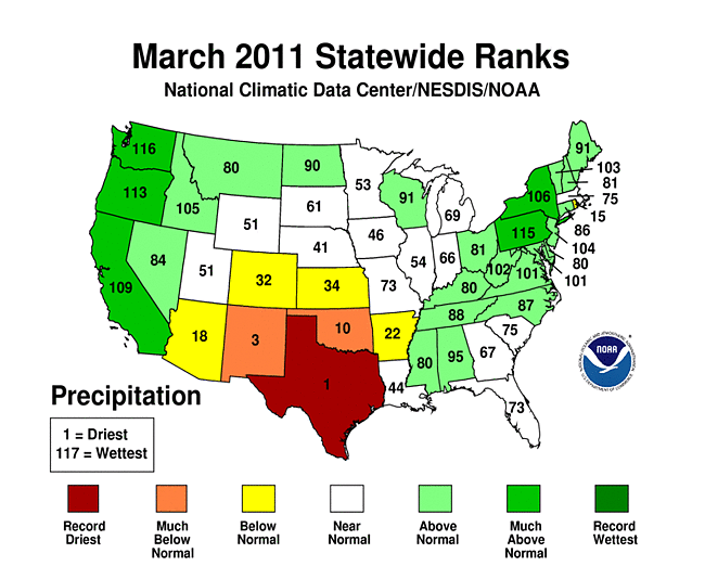
March 2011 was wetter than normal, when precipitation was averaged across the contiguous United States. Statistically, the nationally-averaged precipitation of 2.62 inches made it the 34th wettest March since national records begin in 1895. However, this national average belied regional specifics and even extremes in precipitation when viewed on a map. This pattern can best be described as very dry March conditions in the South Central United States, anchored by the driest March on record for Texas, transitioning to wetter conditions with distance from Texas, finally to very wet conditions along the Pacific Coast and in the Northeast. Regional precipitation extremes were most apparent in the South Climate Region (11th driest March on record) and the Northwest (8th wettest).
The U.S. Drought Monitor drought map valid March 1, 2011.
In a similar sense, the size of drought's footprint remained relatively unchanged, as improvments in the mid-Atlantic and in the Deep South were counterbalanced by deterioration in the Southern Plains and Southern Rockies. By month's end, drought covered about 28% of the contiguous U.S., virtually the same as on March 1st. However, the area of the U.S. that experienced drought conditions of D2 ("Severe") or greater expanded by almost half of its early March coverage, from about 12.5% to about 18.2%. This intensification occurred primarily in the Southern Plains, southern Rockies, and especially in South and West Texas.

The U.S. Drought Monitor drought map valid March 1, 2011.
The March weather pattern was quite active over the United States, as is typical for transition seasons. During the early spring, precipitation tends to be well organized and broad patterns are indeed visible in March's preciptiation values. The series of storm systems that brought this larger-scale precipitation tended to miss, or only lightly brush, much of the Four Corners and Southern Plains regions of the United States, where drought intensified significantly. The Midwest and Northeast were beneficiaries of substantial early-March precipitation, while the Pacific Coast (especially the Pacific Northwest) and Northern Plains saw plentiful precipitation in late March. For a more detailed description of the weather patterns during March, please see the National Overview for March 2011.
By the end of the month, the core drought areas in the U.S. included:
- a wide band of mostly severe (D2) to extreme (D3) drought stretching from southeastern Arizona and the southern Rockies, across the central High Plains and Southern Plains, to the Lower Mississippi River;
- a composite of moderate (D1) to extreme (D3) drought generally worsening from the Piedmont through the Southeast and into the Florida Peninsula; and
- parts of Hawaii, where moderate to extreme drought only modestly declined.
Palmer Drought Index
|
 |
The Palmer drought indices measure the balance between moisture demand (evapotranspiration driven by temperature) and moisture supply (precipitation). The Palmer Z Index depicts moisture conditions for the current month, while the Palmer Hydrological Drought Index (PHDI) and Palmer Drought Severity Index (PDSI) depict the current month's cumulative moisture conditions integrated over the last several months. As seen on the Palmer Z Index map, low precipitation resulted in dry conditions for March 2011 in a band stretching from the Four Corners region to the Arklatex, with an additional area of dryness in the High Plains of Colorado. Wet conditions for March are evident on the Z Index map across much of the Pacific Coast states, from Central California northward, in the Great Basin, Northern Plains, the Appalachians, and Northeast. Near-normal conditions occurred across much of the Central Mississippi and Ohio Valeys. The March 2011 PHDI map indicates that long-term drought remains entranched in the Lower Mississippi Valley, southern Rockies and parts of the Southern Atlantic Coast.
Standardized Precipitation Index
 |
 |
 |
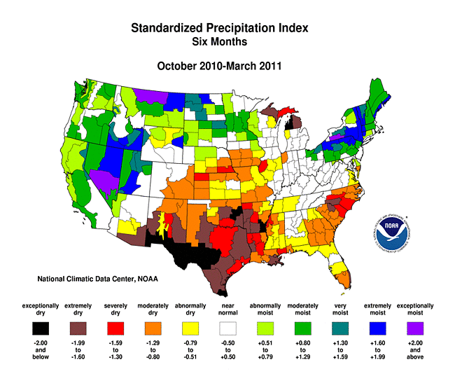
The Standardized Precipitation Index (SPI) measures moisture supply. The SPI maps here show the spatial extent of anomalously wet and dry areas at time scales ranging from 1 month to 24 months. The shorter-term maps (i.e., those sensitive on the one- to three-month timescale) confirm the general patterns described by the Palmer Z index and March precipitation statistics above. On longer timescales, the SPI indicates that lack of precipitation is entrenched in the Lower Mississippi Valley, Gulf Coast and Southern Atlantic Coast and Southern Appalachians on timescales out to 12 months, while the 24-month periods shows little abnormal dryness on a regional scale. The last 12 months have been extraordinarily wet across much of the Midwest and Northern Plains, and the last six months have been quite wet across much of the intermountain West.
 |
 |
 |
Agricultural Indices
 |
 |
Abnormal dryness and drought were evident in several indicators. There were hardly any days with precipitation across Oklahoma, Texas, New Mexico and southern Arizona. This resulted in long runs of consecutive dry days in these areas. Long dry runs (2 weeks or longer) also occurred along much of the U.S. Gulf Coast. On the other hand, it rained or snowed half or more of the days of the month along and near the Appalachians into New England and, especially, in the Northwestern CONUS. During the winter cold season, vegetation goes dormant across much of the country. But soil moisture, as monitored by several models (such as: NOAA Climate Prediction Center percentiles, Leaky Bucket), continued very dry from the Mid-Atlantic states, across the Lower Mississippi Valley and into the Desert Southwest, with areas of dryness in southern Alaska, the High Plains, and the Great Lakes region. Satellite monitoring of vegetation health (Vegetation Drought Response Index) also indicated stress on vegetation in these regions, with additional stress signaled in the Midwest, Ohio Valley and the Piedmont of the Carolinas.
Hydrological Indices
Streamflow (observed and modeled anomalies was below average for the month across much of the South and Southeast, especially the Lower Mississippi River Valey, which has been under longer-term drought.
 |
 |
Regional Discussion
March brought near normal temperatures and very low precipitation for much of Alaska, with the most unusual dryness focused along the mountainous Gulf of Alaska coastline. Dryness in the southern portions of the state is also reflected in the mountain snowpack. For the second straight month, the March 29th USDM map had about a sixth of the state in the abnormally dry category. Longer-term precipitation deficits persisted at the one-year time scale.
Puerto Rico's March precipitation was wetter-than-normal across the western two-thirds of the island, following two dry months island-wide. With the exception of December along the northern coast, Puerto Rico has been mostly dry since October 2010. Abnormally dry (D0) conditions were depicted in southeastern Puerto Rico on the March 15th USDM, marking the first depiction of drought or near-drought conditions for more than a year. At month's end, 29.3 percent of the island was depicted in D0 conditions.
Hawai'i experienced generally near normal precipitation for the month. However, compared to much of 2009 and 2010, the near-normal values were welcomed, as the state is still feeling the effects of long-term drought. Drought conditions improved slightly during the month, but their presence was still widespread.
|
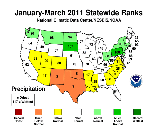 |
On a statewide basis, three states (Texas: driest; New Mexico: 3rd driest; Oklahoma: 10thdriest) had March precipitation among their ten driest in the 1895-present record. Dryness is evident for much of the last 12 months across the Nation's southern tier states, especially Louisiana (4th driest), Arkansas (5th driest), Florida (9thdriest) and Mississippi (10th driest).
Record dryness occurred for several climate divisions for the last several months:
March 2011:
- Louisiana climate division 1;
- New Mexico climate divisions 5, 6, and 8;
- Oklahoma climate division 9;
- Texas climate divisions 3 and 5.
Year-to-date (January-March):
Last 6 months (October-March):
Last 12 months (April-March):
The record dry March 2010-February 2011 followed a record wet March 2009-February 2010 in Arkansas climate divisions 8 and 9. Nine or 10 of the last 12 years had a very dry start (January-February) to the year in the piedmont areas of North Carolina (climate division 3) and Virginia (climate division 3). This is true on a statewide basis for these 2 states (North Carolina, Virginia) and on a regionwide basis for the Southeast region.
More detailed discussion of drought and surrounding weather and climate issues, provided by the NOAA Regional Climate Centers, can be found in the Regional Highlights section of the National Overview. Very brief summaries follow.
- Northeast RCC: March was wet regionally, though southern New England and the coastal mid-Atlantic was dry; Regional precipitation was 139 percent of normal.
- Midwest RCC: " ... at the end of the month, stream flow conditions in the southern half of the region were at or below normal, while they were much above normal in the Upper Mississippi River Basin ... "
- Southeast RCC: Northern Alabama and Georgia recovered from drought during March, along with parts of Virginia and North Carolina. The driest locations in the region were "found across the Florida Panhandle, south Florida, and southeast Puerto Rico ... large parts of eastern and southern Florida remained under extreme (D3) drought conditions throughout the month."
- High Plains RCC: The region was dry overall, and "large areas of Colorado, Kansas, Nebraska, and Wyoming received 50 percent or less of normal precipitation. Pockets of southeastern Nebraska, north-central Colorado, west-central Wyoming, and southern Kansas only got 25 percent or less of normal precipitation ..."
- Southern RCC: Highly variable precipitation occurred in the region, with precipitation generally decreasing toward the west. "Extreme March dryness in Oklahoma and Texas has led to dramatic changes in drought conditions over the past month. As of March 1, 2011, only 10.76 percent of the Southern Region was classified as extreme drought. As of March 29, 2011, that value is now 28.53 or almost three times as high. Most of the extreme drought expansion occurred in southwestern Texas, where precipitation totals for the month of march ranged from 0 to 25 percent of normal ..."
- Western RCC: Much above nromal precipitation from Central California northward. "April 1st snow pack was very healthy throughout the west. Except for those in Arizona and New Mexico, almost all river basins were above 100% of normal for April 1st, on average the date of peak snow water content, and the most important indicator date of the year for spring-summer runoff forecasts ... "
[top]
State/Regional/National Moisture Status
A detailed review of drought and moisture conditions is available for all contiguous U.S. states, the nine standard regions, and the nation (contiguous U.S.):
| northeast u. s. | east north central u. s. | central u. s. |
| southeast u. s. | west north central u. s. | south u. s. |
| southwest u. s. | northwest u. s. | west u. s. |
| Contiguous United States |
[top]
Drought Indicators
- Palmer Drought Indices
- Standardized Precipitation Index
- long-term (36 to 60 month) percent of normal precipitation maps
- airport station percent of normal precipitation maps
- statewide precipitation rank maps
- Cooperative station percent of normal precipitation maps
- percent of average maps for the SNOTEL stations in the western mountains provided by the Western Regional Climate Center
- hydrologic year precipitation
- snow water equivalent of snowpack
- satellite-based observations of vegetative health
- National Weather Service model calculations of soil moisture, runoff, and evaporation
- National Weather Service model calculations of soil moisture using the Leaky Bucket Model
- topsoil moisture conditions observed by the USDA and mapped by the Climate Prediction Center
- pasture and range land conditions observed by the USDA and mapped by the Climate Prediction Center
- streamflow maps maintained by the USGS
[top]
Contacts & Questions