|
Contents Of This Report: |

|
National Drought Overview
|
|
[top]
Detailed Drought Discussion
August 2010 was drier (34th driest) and warmer (7th warmest) than normal when weather conditions are averaged across the country. But considerable variability occurred throughout the month (weeks 1, 2, 3, 4, 5) and on a regional basis. Spotty beneficial rain fell across parts of the drought (D1-D4) and abnormally dry (D0) areas of the Southeast, West, and Alaska, but the remaining D0-D4 areas saw little beneficial rain. Areas of D0-D2 expanded (end of August USDM compared to end of July USDM) from the southern Plains to the East Coast under excessive heat and deficient rainfall. The unusually warm conditions enhanced evaporation which, combined with the sub-normal precipitation, stressed vegetation in many areas. August continued a period of prolonged dryness over Hawaii. By the end of August, drought or abnormally dry areas intensified or expanded in parts of the northern and central East Coast, southern and northern Plains, Lower to mid-Mississippi Valley, and Ohio Valley, but contracted in Alaska and parts of the Southeast, and changed very little in Hawaii and the West.

The U.S. Drought Monitor drought map valid August 31, 2010.
The  weather pattern for August was a continuation of the pattern which has dominated this summer. The North Atlantic High pressure system held sway over much of the eastern and southern United States, bringing sunny skies and much above-normal temperatures, while dips — or troughs — in the upper-level jet stream kept above-normal temperatures from dominating much of the western states. The hot temperatures in the East and South increased evaporation, and August 2010 ranked in the top ten warmest category for several Great Lakes and southern states. While the North Atlantic High (also known as the Bermuda High) dominated in the South, the jet stream was active across the northern tier states. A number of summertime low pressure systems and cool fronts brought areas of rain and severe weather to the north. But precipitation in the northern states, as well as across the rest of the country, was spotty — typical of late summer. With the Bermuda High prevailing over the South, tropical systems were mostly deflected out into the Atlantic. Moisture from a dissipated Gulf of Mexico tropical depression, and a few cold fronts that penetrated into the southern states, brought scattered showers and thunderstorms to the South, but a large swath of the country from Texas to the southern Great Lakes and Mid-Atlantic was drier than normal.
By the end of August, core drought areas in the U.S. included:
- much of Hawaii, where moderate (D1) to exceptional (D4) drought was entrenched;
- the Lower Mississippi Valley, where moderate (D1) to extreme (D3) drought persisted;
- the western Great Lakes, where moderate (D1) to severe (D2) drought conditions lingered; and
- the Mid-Atlantic coast (displayed on the Northeast and Southeast maps), where moderate (D1) to severe (D2) drought developed this summer.
 |
 |
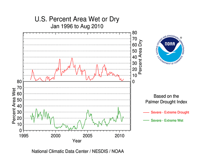
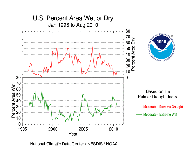
The Palmer drought indices measure the balance between moisture demand (evapotranspiration driven by temperature) and moisture supply (precipitation). The Palmer Z Index depicts moisture conditions for the current month, while the Palmer Hydrological Drought Index (PHDI) and Palmer Drought Severity Index (PDSI) depict the current month's cumulative moisture conditions integrated over the last several months. As seen on the Palmer Z Index map, low precipitation and hot temperatures resulted in unusually dry conditions for August 2010 over the much of the southern and eastern United States, although enough beneficial rain fell in some areas to create a spotty pattern on the map. Rain from Atlantic Tropical Depression Five brought above-normal precipitation to southeast Louisiana and southern Mississippi, and frontal showers and thunderstorms gave the northern Plains and northern Rockies states a wet month. Compared with the July 2010 PHDI map, the August 2010 PHDI map indicates that drought conditions worsened over the Mid-Atlantic states and Mid-Mississippi Valley to lower Ohio Valley. The August 2010 PHDI map also reflects the long-term nature of the drought conditions. The Z Index and PHDI maps in combination show that the dryness in the Lower to mid-Mississippi Valley is both a short-term and long-term phenomenon, that dryness in the Mid-Atlantic to Southeast states has persisted long enough to show up in the long-term PHDI depiction, and dryness is expanding in the short-term into the Ohio Valley, southern Great Lakes, and more of the southern Plains.
 |
 |
 |
The Standardized Precipitation Index (SPI) measures moisture supply. The six SPI maps here show the spatial extent of anomalously wet and dry areas at time scales ranging from one month to 24 months. Summer rainfall has reduced the drought footprint in the western Great Lakes, but residual deficits remained at longer (12-24 months) timescales. The Southeast and Mid-Atlantic states have had a dry spring and summer this year, marking a shift from a wet 12- to 24-month timescale. The Lower to mid-Mississippi Valley dryness extends back nine months, but wet conditions dominated earlier. The southern Plains, Ohio Valley to southern Great Lakes, and Pacific Northwest dryness is a recent (1- to 2-month) phenomenon. The northern Rockies have been wet this spring and summer, but the dry winter has kept the 12-month SPI in the negative (dry) category. A wet winter in the Southwest is responsible for wet SPI values at 9 months, but the area has had spotty dryness in recent months and spotty dry conditions at the longer (24-month) timescale. The central to northern Plains and adjoining Midwest are depicted as persistently wet at most time scales.
 |
 |
 |
Did You Know?
Expand "Satellite-Based Drought Indicators"
Satellite-Based Drought Indicators
The most accurate assessment of drought and climatic conditions can be made by taking measurements of the climatic conditions where the climate is happening — on the ground or in the atmosphere. These are called in situ observations. There are several valuable in situ observational networks around the world that provide crucial data to support weather forecasters, industries and economies, and government and private sector decision makers and policy makers. To get the best information, networks with many stations spaced close together (high spatial density) are needed, but this kind of dense spatial coverage can be expensive. In their high earth orbits, satellites can supplement in situ data by providing consistent observations at high spatial density with global coverage.
Satellites measure energy intensities (radiances) at several wavelengths of the electromagnetic spectrum. This information is useful because everything — the ground, the oceans, the atmosphere, clouds, rain, vegetation, cities, people, etc. — absorbs energy at certain wavelengths and emits energy at other wavelengths. You may be familiar with some of these: visible satellite imagery of clouds showing the movement and strength of storms and fronts; infrared imagery which measures the temperature of clouds and weather systems; water vapor maps generated from a spectroscopic analysis of satellite data.
Two commonly-used satellite-based drought indicators are the Vegetation Health Index (VHI) and Vegetation Drought Response Index (VegDRI).
- The VHI is a NOAA product that contains several indices derived from polar-orbiting NOAA satellites. The data and images have global coverage and represent average conditions over a 7-day period. The VHI monitors the health of vegetation regardless of the cause. Poor vegetation health, as indicated by the VHI, may be due to stress caused by drought, stress caused by too much water (e.g., flooding), or some other cause (such as insect infestation).
- The VegDRI product is produced by the National Drought Mitigation Center (NDMC) in collaboration with several other partners. It is a national map covering the contiguous U.S. produced every two weeks and provides regional to sub-county scale information about drought's effects on vegetation. It is a unique hybrid product, in that the VegDRI calculations integrate satellite-based observations of vegetation conditions with in situ climate data and other information such as land cover/land use type, soil characteristics, and ecological setting. The VegDRI monitors the health of vegetation as it is specifically related to drought.
The precipitation pattern in Alaska for August 2010 was mixed, but enough rain fell to further contract the D0 area in the south. Precipitation surpluses existed across many stations at the three month to six month and year-to-date time scales. However, significant precipitation deficits remained at many stations at longer time scales (water year to date, 12 months, 24 months, and 36 months). The streamflow pattern in Alaska during August was mixed.
The precipitation pattern during August in Puerto Rico was mixed, with above-normal rainfall in the northwestern half of the island and below-normal rainfall in the southeastern half. A similar pattern is evident in precipitaton anomaly maps for other time periods (last 60, 90, and 180 days, year-to-date, and water year-to-date [October-August]). Streamflow for Puerto Rico was above normal and the island remained drought free on the August 31st USDM map.

June-August precipitation, 1940s or 1950s through 2010, at 4 Hawaiian stations.
While above-normal precipitation fell across a few parts of the Hawaiian Islands during August, for most stations it was a drier-than-normal month. Long-term deficits (last 3, 6, 12, 24, 36 months) continued to mount. At four of the primary weather stations in the state, 2010 has had near-record dryness at several levels (percentile maps at 90 days and 365 days). At Honolulu, Kahului, and Lihue, summer (June-August) is the dry season, but substantial rain normally falls at Hilo every month of the year. The summer rainfall pattern at these four stations shows a noticeable drying trend over the last 20 years, most notably at Hilo. Although 2010 and recent years have been dry, records dating back to the 1940s and 1950s reveal drier periods in the past, especially in the late 1970s and early 1980s, and around 1960. The precipitation data for 12-month, 24-month, and 36-month time periods ending in August also show drying trends over the last 30 to 40 years at the four stations (Hilo, Honolulu, Kahului, Lihue). The percent area of the state classified in moderate (D1) to exceptional (D4) drought at the end of August remained unusually high (69 percent), with virtually the entire state experiencing abnormally dry to exceptional drought conditions. Very poor pasture conditions significantly impacted cattle ranching operations. Early August reports indicated that, on Oahu, the Waimanalo Reservoir remained low, and a mandatory 30 percent cutback was still active for irrigation water use. As noted in the narrative discussion for the August 31, 2010, USDM: Mandatory water conservation measures remained in effect for Maui and Honolulu Counties. By the end of August, a wildfire on the Big Island in the mountains southeast of Waikoloa was still not fully contained. The fire had charred nearly 1,400 acres of brush and grass. August streamflow levels were below normal across most of the islands and much below normal on Maui.
 |
 |
 |
 |
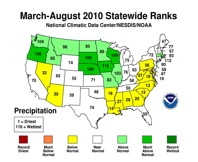
On a statewide basis, August 2010 was drier than normal for some states in the intermountain basin of the West and in the Northeast, and for many states from the southern Great Lakes to southern Great Plains. Indiana had the third driest August in the 116-year record. The summer (June-August) and last six months (March-August) were drier than normal for parts of the West and especially dry for the Mid-Atlantic to coastal Southeast states. New Jersey had the 12th driest summer and 6th driest April-August on record. The opposite conditions prevailed for the East and South at the 12-month time scale with many states having a wetter-than-average September-August.
 |
 |
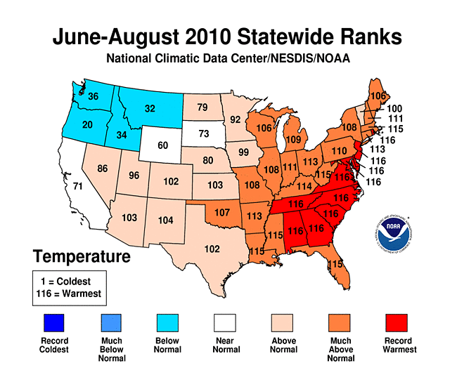
Unusually hot temperatures increased evaporation across much of the country east of the Rockies during August. This month culminated in a record hot summer for the Mid-Atlantic to Southeast states and a record hot March-August for the Mid-Atlantic to Northeast states.
 |
 |
Abnormal dryness and drought were evident in several indicators. August is the dry season across the coastal West, so it is normal to have few days with rain in this area. But there were just a handful of days with rain this month across much of the southern Plains to southern Great Lakes and in parts of the northern Plains and Mid-Atlantic to Northeast. This resulted in long runs of consecutive dry days in some areas. The August heat magnified the effects of the dry weather, drying soils and stressing vegetation. Soil moisture, as observed (percent of topsoil dry and very dry, and comparison to 5-year average and 10-year average) and as monitored by several models (NOAA Climate Prediction Center anomalies and percentiles, Leaky Bucket, NLDAS [North American Land Data Assimilation System] top soil layer and total soil layer, VIC [University of Washington Variable Infiltration Capacity macroscale hydrologic model]), was drier than average across much of the country from the Mid-Atlantic to the southern Plains; most of New England, the Pacific Northwest, the central Plains, and the central Rockies; and parts of the intermountain basin, Alaska and Hawaii. According to September 5th U.S. Department of Agriculture (USDA) reports, 80 percent or more of the topsoil was rated short or very short (dry or very dry) in Arkansas (86 percent), West Virginia (82 percent), Kentucky and Connecticut (both 80 percent).

Vegetation Drought Response Index (VegDRI), September 6, 2010.
Like last month, rainfall was spotty during August and persistently hot temperatures led to heat stress in some crops in the Mid-Atlantic to Southeast by the end of the month. These impacts are reflected in the weekly Palmer Crop Moisture Index (CMI), which was developed to assess moisture conditions as they specifically relate to crops, and in other indicators. The beginning-of-September CMI showed excessively dry conditions from the Mid-Atlantic to Southeast, from the Ohio Valley to Lower Mississippi Valley, and across parts of the West. Satellite monitoring of vegetation health (Vegetation Drought Response Index, Vegetation Health Index), and the U.S. Geological Survey (USGS) agro-hydrologic model (Soil Water Index [SWI], Water Requirement Satisfaction Index), indicated stress on vegetation across much of the country, with the greatest stress ("wilting" category on the SWI) from the southern Great Lakes to southern Plains, much of the West, and parts of New England and the central Plains. In fact, the only widespread areas without stress were across parts of the Gulf Coast including much of Florida, the Midwest centered around Iowa, and the northern High Plains. Drought impacts were showing up on the pastures and rangeland from New England to the Lower Mississippi Valley, with half or more of the pastures and rangeland rated in poor or very poor condition in Arkansas (67 percent), Virginia (56 percent), West Virginia (55 percent), and Connecticut (50 percent). According to September 5th USDA reports, a third or more of the corn and/or soybeans were rated in poor or very poor condition in Virgnia (55 and 34 percent, respectively), West Virginia (44 and 35 percent), Maryland (46 and 30 percent), Delaware (44 and 22 percent), and North Carolina (37 and 20 percent). In addition, 72 percent of the apple crop in West Virginia was rated poor or very poor. Virginia's preliminary 2010 corn yield estimate of 65 bushels per acre, if realized, will be the state's lowest since 1993 (60 bushels per acre) (USDA).
More well monitoring stations (real-time network, climate response network, total active network) in many areas showed low groundwater this month compared to a month ago. Streamflow (observed and modeled [CPC 1-month, VIC 1-month, 3-month, 6-month]) was below average across parts of the East from New England to the Lower Mississippi Valley, and most of Hawaii.

Percent area of the Western U.S. in moderate to extreme drought, January 1900-August 2010, based on the Palmer Drought Index.
August 2010 was drier than normal across much of the western United States. But more important for the West is precipitation that falls throughout the water year, defined as October through the following September. The water-year-to-date (October-August) precipitation pattern has been mixed at the low elevation stations and high elevation (SNOTEL network) stations. An analysis by the USDA indicated that reservoir levels were generally below average from parts of the Pacific Northwest to the interior basins. Based on data from the U.S. Bureau of Reclamation, Lake Mead water levels have dropped as low as they were during the 1950s drought and in the 1960s when Lake Powell upstream was filled. The August 2010 level was at 1086.91 feet, compared to 1083.57 feet in March 1956 and 1088.14 feet in December 1964. A forecast of La Niña, which would bring continued dry conditions to the region for the next year or more, has prompted concerns that the lake could recede to a level not seen since it was first being filled in the 1930s, resulting in water supply problems for Arizona, Nevada, California, and northern Mexico (Greenwire, 8/12, revised with the latest statistics). According to the USDM, six percent of the West was experiencing moderate to severe drought at the end of August, about the same as July, while the Palmer Drought Index statistic hovered around twelve percent.
As noted by the Southeast Regional Climate Center, monthly precipitation was highly variable across the Southeast in August. In particular, there was a marked increase from July in the areal coverage of above average precipitation. The wettest locations were found through central portions of Virginia and North Carolina, eastern South Carolina, central and southern Georgia, western Alabama, and southern Florida, where precipitation for the month was between 200 and 300 percent of normal. Along coastal sections of Alabama and western Florida, the remnants of Tropical Depression Five brought heavy rain over a three-day period in the middle of the month. More than 4 inches (101.6 mm) of rain fell near Mobile, Alabama, resulting in major flooding and disruption to the city's water supply system. The storm had earlier produced heavy rain and severe weather over Florida prior to becoming a tropical depression. In particular, Bradenton, Florida, recorded a monthly record 24-hr rainfall of 6.12 inches (155.45 mm) on the 8th of the month, which broke the old record by over two inches. The driest locations across the Southeast in August (less than 50 percent of normal) were in southeastern portions of Virginia and North Carolina, southwest North Carolina, and eastern portions of Alabama and Florida. Monthly precipitation was highly variable across Puerto Rico (200 percent of normal across the northern half of the island to less than 50 percent across the southern half). The summer rainfall total of 26.15 inches (664.21 mm) recorded at San Juan airport was just 0.03 inch (0.76 mm) shy of breaking the old record set back in 1950. In contrast, there were many locations in the Southeast that experienced significant summer season precipitation deficits. It was the third driest summer ever and the driest in over 80 years in the Richmond, Virginia area, in a record extending back to 1887. The Orlando, Florida area experienced its driest summer ever in a record extending back to 1948 with just 13.11 inches (332.99 mm).
The beneficial rainfall in August helped ameliorate drought conditions in many parts of the Southeast, although roughly half the region still displayed D0 (abnormally dry) or greater conditions by the end of the month. The most notable change in the USDM occurred through central portions of Virginia and North Carolina, where regions of moderate drought (D1) were completely eliminated. Conditions in western North Carolina and northwest South Carolina improved from D1 to D0, while D0 conditions in northern Alabama, Georgia, and southeast South Carolina were also eliminated. Unfortunately, the beneficial August rains did not extend to the driest parts of the region. Severe drought (D2) continued to be observed across large portions of eastern Virginia, with moderate drought (D1) persisting across much of southeastern North Carolina. This has resulted in a loss of up to 80 percent in corn crop yields in the region and further reductions in soybean, cotton, and peanuts. In addition, the increased rainfall coupled with warm temperatures in Georgia lead to one of the worst infestations of army worms and white mold in hayfields and pastures in more than 25 years.
Average temperatures for August 2010 were above normal across the Southeast. Departures from normal ranged from 1 to 3 °F (0.5 to 1.6 °C) above normal near the coasts (including Puerto Rico) to 5 to 6 °F (2.7 to 3.3 °C) above normal across portions of central Alabama and North Carolina. Over 20 locations experienced their warmest August on record, including Gainesville, Florida; Columbus, Georgia; Greensboro, North Carolina; Charleston, South Carolina; and Greenville, South Carolina. Much of the overall warmth observed across the region since April can be tied to exceptionally warm overnight temperatures. This was again the case in August, with over 1,800 record daily high minimum temperatures tied or broken during the month. Atmospheric water vapor contents were unusually high in August across much of the Southeast and this contributed to the warm overnight temperatures and greater rainfall (see below). The end of August marked one of the warmest meteorological summers (June-August) on record across a large portion of the Southeast. Over 150 locations in the region experienced their warmest summer on record, including Miami, Florida; Washington, D.C.; Greensboro, North Carolina; Roanoke, Virginia; Birmingham, Alabama; and Charleston, South Carolina. The anomalous warmth this summer, particularly overnight, resulted in significant increases in air conditioning cooling demand. In Atlanta, Georgia, for example, cooling demand was 28 percent above normal for the summer, up from 23 percent last summer.
As explained by the Southern Regional Climate Center, August precipitation totals varied significantly throughout the Southern region. In general, the majority of the region experienced a drier than normal month; however, there were some areas where it was quite wet. Conditions were quite dry in southern Texas, with the majority of stations reporting less than five percent of the monthly normal. In fact, some stations did not receive any rainfall for the entire month. Some examples include San Manuel, Mercedes 6 SSE, La Joya, Eagle Pass and Calliham. The state of Texas averaged 1.23 inches (31.24 mm) of precipitation for the month, which was the 21st driest August on record (1895-2010). Conditions were also quite dry in southern Oklahoma and northeastern Arkansas, where most stations reported less than a quarter of the monthly normal. Arkansas averaged 1.75 inches (44.45 mm) of precipitation for the month, which was the 15th driest August on record (1895-2010). In northern Mississippi, conditions were also dry, with the majority of stations reporting between 50 to 70 percent of normal for the month.
August was a very warm month throughout the region. The highest departures from normal were observed in Arkansas, eastern Oklahoma, northeastern Texas, northern Mississippi and western Tennessee. Most stations in the region reported average monthly temperatures that ranged from 2 to 6 °F (1.11-3.33 °C) above expected normals, while some stations reported as high as 8 °F (4.44 °C) above normal. Louisiana reported a state-wide average temperature of 84.9 °F (29.39 °C), which was the second warmest August on record (1895-2010). This monthly average was also tied for the third warmest month in Louisiana (1895-2010). Tennessee also reported its second warmest August on record (1895-2010) with an average temperature of 80.10 °F (26.72 °C). Elsewhere, Arkansas reported its eighth warmest August (1895-2010) with a state average temperature of 83.90 °F (28.83 °C), while in Texas, temperatures averaged 84.40 °F (29.11 °C), which was the ninth warmest August on record (1895-2010). The state-wide average August temperature for Mississippi was 83.50 °F (28.61 °C), or the ninth warmest August on record (1895-2010). In Oklahoma, it was the 16th warmest August on record (1895-2010) with an average state temperature of 83.80 °F (28.78 °C). In total, the Southern Region's weighted average temperature was 83.89 °F (28.83 °C), which is the fourth warmest August on record (1895-2010).
Drought conditions in the Southern region changed significantly over the past month. Due to dry conditions throughout most of Arkansas, much of the eastern and northern areas of the state were classified as being in moderate drought conditions by the end of the month. In Texas, a new area of moderate drought was designated within and about the Edwards Plateau Climate Division. In addition, much of central Texas now had abnormally dry conditions, meaning that if dry conditions do not improve, drought could be observed in the very near future. Elsewhere, drought conditions did not change significantly. In total, 21.8 percent of the Southern region was experiencing moderate drought by the end of August, which is 10.3 percent higher than the start of the month. In Texas, excessive heat gripped the state through most of the month. Unfortunately, there were several reports of heat-related deaths, including at least 3 small children that were left in vehicles for prolonged periods of time. The heat caused electricity usage in Texas to reach a new record level of 65,715 megawatts on August 30, 2010, the fourth straight week of record-setting usage in Texas. Reports of grassfires increased as the month progressed, as dry conditions turned vegetation that grew during a moisture-rich first seven months of 2010 into kindling. By the end of the month, 80 Texas counties had burn bans including Austin, Brownsville, Fort Worth, and San Angelo. (Information provided by the Texas State Climate Office.)
As summarized by the Northeast Regional Climate Center, August averaged on the dry side in the Northeast. The regional total of 3.51 inches (89.2 mm) of precipitation was 89 percent of normal and 0.43 inches (10.9 mm) less than the same month in 2009. It was the driest August since 2002. Three states — Maryland (102 percent), Massachusetts (105 percent) and New York (114 percent) — had above normal totals; departures in the remaining states ranged from 51 percent of normal in New Jersey to 96 percent of normal in Vermont. New Jersey had its 15th driest August since 1895. The three-month average of 11.62 inches (295.1 mm) was 96 percent of the normal amount. New Jersey had its 15th driest summer in 116 years with only 67 percent of the normal summer rainfall. Of the 12 states in the region, New York had the wettest summer, with 113 percent of normal precipitation.
While August 2010 was not as steamy as July 2010, the run of above normal temperatures that began in January 2010 continued. With an average of 69.8 °F (21.0 °C), the Northeast had its 8th consecutive warmer-than-normal month. In addition, it was the 6th month in a row with all states in the region having above normal averages. Four states in the region — Delaware, Maryland, New Jersey and Rhode Island — had their warmest summer (June through August) since 1895. In addition, it was the 2nd warmest in Massachusetts and West Virginia; the Northeast also placed 2nd warmest with a 3-month average of 70.0 °F (21.1 °C).
The drought situation changed slightly during the month as indicated in the August 31, 2010 USDM. By the end of August, portions of east central Maine had moderate drought conditions (D1), and abnormally dry conditions (D0) were present in the rest of the state except for coastal Maine, which was normal. D0 conditions expanded in New Hampshire and West Virginia, but conditions improved in most of Pennsylvania. In West Virginia, severe drought conditions (D2) expanded into eastern Mineral and all of Hampshire and Handy Counties in the eastern panhandle, while D1 conditions stretched into Preston, Tucker and Pendleton Counties. In New York, rainfall eased the abnormally dry conditions in the southern Hudson Valley, but the lack of rain along the coast led to D1 conditions in central portions of Long Island. Conditions in the western Maryland panhandle deteriorated from D0 at the end of July to D1 on August 31st, while southeastern Maryland saw improvement from D2 to D1 conditions in Wicomico, Worcester and Somerset Counties.
Warm and dry weather impacted crops and pastures in West Virginia, Maryland and Delaware, with reports of reduced yields and conditions mainly ranging from poor to fair. Conditions elsewhere in the region were not as bad, with most crop progress ahead of normal and in fair to excellent condition, especially fruit and vegetables with access to irrigation.
While the agricultural industry suffered in parts of the Northeast, the tourist industry benefitted from terrific vacationing weather. The New Hampshire State Climatologist reported that "the nearly perfect weather conditions this August led to an increase in tourism revenue, compared to the disappointing summer 2009 season, including an increase in hotel occupancy, with packed beaches and state parks."
According to the New Jersey State Climatologist, there were reports of flow ceasing in a few small streams and some ponds were close to drying up, shallow-rooted trees (deciduous and conifers) were dying, and the understory of forests and many shrubs were withered.
As noted by the Western Regional Climate Center, the precipitation pattern was mixed. The West Coast and Sierra/Cascades were dry but the intermountain region had pockets of above and below normal rainfall. The Four Corners region of the Southwest had a definite positive departure for the month. The monsoon season has been active near the Arizona/New Mexico border. Parts of northern Arizona experienced a very wet July and August. The 9.45 inches (240 mm) of rain in Flagstaff was the wettest July-August total in Flagstaff since 1986. Some automated stations in Arizona received nearly 16 inches (406 mm) of rain for these two months. Billings, Montana recorded its 2nd wettest August since 1934, with 2.78 inches (71 mm), and 2nd wettest summer (Jun-Aug) with its 9.58 inches (243 mm) just shy of the 1944 record of 9.90 inches (251 mm). Conversely, the Pacific Northwest rainfall totals for July and August have been well below average with Seattle's July and August total at roughly 30 percent of normal. The first snows of the new winter coated the mountaintops of southwest Montana on the 22nd.
Temperatures were moderately above normal in the western High Plains, Southern Rockies, and New Mexico and Arizona. They were slightly cooler than normal in the northwest quarter of the region, and in central California and all along the West Coast. Coastal California continued its foggy summer, one of the coolest on record, up until the 24th when the first brief summer heat wave finally arrived. Until then, San Diego had recorded all but one day with below normal temperatures for the month as had San Francisco to the north. From May 1st until the 71 °F (21.6 °C) reading on August 23rd, Bodega Bay, California, had failed to rise above 64 °F (17.8 °C). Eureka, California, has had only one day with a temperature of 70 °F (21.1 °C) or higher (73 °F on August 24th) from May through August. The month and summer have been the coolest in a decade along the California coast, and the coolest since 1982 in San Jose. Daytime maximum temperatures have been notably low, and in San Diego were the coldest since 1933. By contrast, Clayton, New Mexico saw its 2nd warmest August since 1897.
As explained by the High Plains Regional Climate Center, precipitation varied across the High Plains region, but August 2010 was warmer than normal for much of the region. In the wet areas, the warm temperatures were welcome as this aided in crop development and the harvest of small grains. However, in areas which have been dry, the warm temperatures stressed some row crops and livestock. Overall, the summer (June, July, and August) was also warmer than normal for many locations in the region.
Precipitation was spotty across the High Plains region this month. Some areas, including central South Dakota, northern Nebraska, eastern and west central Kansas, and central and eastern Wyoming, received precipitation which was only 50 percent of normal or less. Meanwhile, other areas, including southeastern South Dakota, eastern Colorado into southwestern Nebraska, and central Kansas, received greater than 150 percent of normal precipitation. These precipitation totals were not enough to break records in August, however new precipitation records were set for the summer.
While overall, summer 2010 was wet for many locations across the High Plains region, some locations were drier than normal which led to significant changes in the USDM depiction this month. Early in the month, pockets of abnormally dry conditions (D0) were introduced to north central South Dakota, southeastern Nebraska, and northern Kansas. Later in the month, moderate drought conditions (D2) developed in north central South Dakota as little rain fell, and D0 conditions were also expanded into North Dakota. Meanwhile, drought conditions remain unchanged in Wyoming and the D0 area in Colorado was trimmed slightly.
As summarized by the Midwest Regional Climate Center, August was warm across the Midwest. Daily temperature records were skewed strongly towards record highs (over 1000) versus record lows (less than 100) for the month. Summer (June, July, and August) temperatures were also above normal. August precipitation ranged from less than 50 percent of normal to more than 200 percent of normal. Several states reported both extremes. There were three areas that reported less than 50 percent of normal precipitation: southern Missouri, southern Indiana, and southern Michigan. Summer precipitation was more than double the normal amount in a swath that included northwest, central, and southeast Iowa, northeast Missouri, and west central Illinois. Most of the region was above normal with only southern Missouri and the lower Ohio River valley less than 75 percent of normal for the summer. Dry weather in the southern and eastern parts of the Midwest led to the introduction of drought and large areas of abnormally dry conditions in the USDM.
[top]
State/Regional/National Moisture Status
A detailed review of drought and moisture conditions is available for all contiguous U.S. states, the nine standard regions, and the nation (contiguous U.S.):
| northeast u. s. | east north central u. s. | central u. s. |
| southeast u. s. | west north central u. s. | south u. s. |
| southwest u. s. | northwest u. s. | west u. s. |
| Contiguous United States |
[top]
Drought Indicators
- Palmer Drought Indices
- Standardized Precipitation Index
- long-term (36 to 60 month) percent of normal precipitation maps
- airport station percent of normal precipitation maps
- statewide precipitation rank maps
- Cooperative station percent of normal precipitation maps
- percent of average maps for the SNOTEL stations in the western mountains provided by the Western Regional Climate Center
- hydrologic year precipitation
- snow water equivalent of snowpack
- satellite-based observations of vegetative health
- National Weather Service model calculations of soil moisture, runoff, and evaporation
- National Weather Service model calculations of soil moisture using the Leaky Bucket Model
- Midwest Regional Climate Center model calculations of soil moisture
- topsoil moisture conditions observed by the USDA and mapped by the Climate Prediction Center
- pasture and range land conditions observed by the USDA and mapped by the Climate Prediction Center
- streamflow maps maintained by the USGS
[top]
Contacts & Questions