|
Contents Of This Report: |

|
National Drought Overview
|
|
[top]
Detailed Drought Discussion
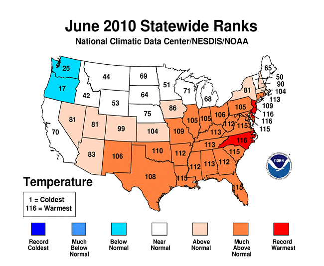
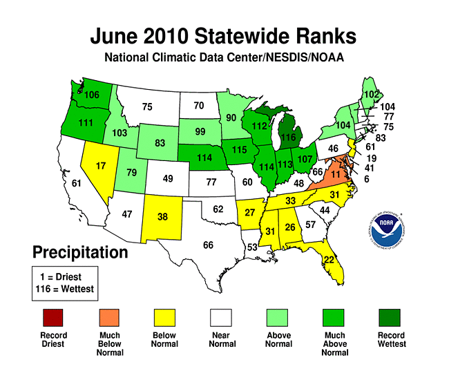
June 2010 was wetter (17th wettest) and warmer (8th warmest) than normal when weather conditions are averaged across the country. But considerable variability occurred throughout the month (weeks 1, 2, 3, 4, 5) and on a regional basis. Beneficial rain fell across the Great Lakes, Pacific Northwest, and northern Rockies, while much of the Southwest, Lower Mississippi Valley, Southeast, and mid-Atlantic states were drier than normal. The dryness in the South and East was accompanied by unusually warm conditions which enhanced evaporation. Prolonged dryness continued over Hawaii. By the end of June, drought or abnormally dry areas intensified or expanded in parts of the Southwest, Lower Mississippi Valley, southern Plains, mid-Atlantic states, and Hawaii, but contracted in the Pacific Northwest, northern Rockies, western Great Lakes, and Northeast.

The U.S. Drought Monitor drought map valid June 29th, 2010.
The  weather pattern for June consisted of an extension of the North Atlantic High pressure system which brought hot and dry weather to the southern and eastern United States. A few cold fronts managed to penetrate into the Southeast and mid-Atlantic states, but widespread frontal precipitation was inhibited by the descending air associated with the North Atlantic High. An upper-level trough persisted over the Northwest, keeping cool and wet weather over the area. The storm track was sandwiched in between these two controlling systems, with several weather systems moving along the storm track bringing record and near-record wet conditions to several central states, including beneficial rain over the drought areas of the western Great Lakes.
By the end of June, core drought areas in the U.S. included:
- parts of Hawaii, where moderate (D1) to exceptional (D4) drought expanded;
- the western Great Lakes, where moderate (D1) to extreme (D3) drought conditions persisted in spite of some recovery this month;
- the Lower Mississippi Valley and southern Plains, where extreme (D3) drought was introduced over northern Louisiana and moderate (D1) to severe (D2) drought developed over north central Texas;
- parts of the Far West and northern to central Rockies, which had areas of moderate (D1) to severe (D2) drought, and Southwest, where the delayed onset of the Southwest monsoon resulted in expansion of moderate to severe drought; and
- parts of the Southeast to mid-Atlantic states, where areas of moderate drought (D1) had developed or abnormal dryness (D0) had expanded.
|
 |
The Palmer drought indices measure the balance between moisture demand (evapotranspiration driven by temperature) and moisture supply (precipitation). The Palmer Z Index depicts moisture conditions for the current month, while the Palmer Hydrological Drought Index (PHDI) and Palmer Drought Severity Index (PDSI) depict the current month's cumulative moisture conditions integrated over the last several months. Unusually dry conditions for June 2010 were evident on the Palmer Z Index map over the much of the mid-Atlantic to Southeast, while unusually wet conditions occurred over the Pacific Northwest to northern Rockies, central Plains to Midwest, and Great Lakes to northern parts of the Northeast. Compared with the May 2010 PHDI map, the June 2010 PHDI map indicates that drought conditions improved over parts of the northern Rockies and Great Lakes, but they deteriorated over parts of the mid-Atlantic, Southeast, and Lower Mississippi Delta states. The June 2010 PHDI map also reflects the long-term nature of the drought conditions over the western Great Lakes. The Z Index and PHDI maps in combination show that the dryness in the Lower Mississippi Valley is both a short-term and long-term phenomenon and that the short-term dryness in the mid-Atlantic to Southeast states is beginning to be reflected in the long-term conditions.
 |
 |
 |
The Standardized Precipitation Index (SPI) measures moisture supply. The six SPI maps here show the spatial extent of anomalously wet and dry areas at time scales ranging from one month to 24 months. Abundant precipitation over the western Great Lakes and northern and central Rockies in recent months has brought short-term relief, but it has not been enough to erase deficits that extend out six to 24 months. Recent precipitation in the Pacific Northwest, however, has largely negated the longer-term dryness in that region. The Northeast areas bordering the Great Lakes have received above-normal rainfall in recent months but still have precipitation deficits at six to nine months. On the other hand, areas of the Northeast along the Atlantic coast have been dry in recent months but wet at the longer time scales. Likewise, parts of the mid-Atlantic to Southeast states have precipitation deficits from one to six months but precipitation surpluses at the longer time scales. The Lower Mississippi River Valley has been dry for the last six months, with the dryness in northern Louisiana being so severe that it has neutralized the longer-term precipitation surplus. The precipitation pattern for the Southwest is dry in recent months, wet at mid-temporal scales (six to nine months), and dry at the longer time scales (12 to 24 months). The central Plains to adjoining Midwest is depicted as persistently wet at all time scales.
 |
 |
 |
Did You Know?
Streamflow Drought Indicators
Streamflow levels are a useful indicator for drought as well as floods, but they must be used with considerable caution. For streams that are regulated, the streamflow may reflect management decisions at upstream reservoirs which will not reflect true drought conditions. Streams that are unregulated are better for drought monitoring. A hydrograph is used to show stream discharge (water level) over time. When a precipitation event occurs over a river basin, the discharge increases to a high level (peak flow), then gradually decreases to near the base flow after the precipitation event ends. The time it takes to reach peak flow and the magnitude of the peak flow are useful for flood forecasting. Base flow is the level the stream would have if no precipitation occurred over the basin and is generally fed by groundwater. Base flow is the best streamflow indicator for drought monitoring. In practice, however, the weather doesn't cooperate to provide widespread measurements of base flow at a network of river gauge stations on an operational basis — at any given time, streamflow measurements across the nation are a mix of peak flow, base flow, and everything in between. Consequently, streamflow measurements are averaged over several days to a month to indicate areas with low streamflow and, by implication, low groundwater levels. The values are compared to the local streamflow history, converted into percentiles, and grouped into above- and below-normal percentile classes to be used as an indicator for drought classification.
In Hawaii, the percent area classified in moderate (D1) to exceptional (D4) drought rose from 50 percent at the end of May to 73 percent by June 29. When abnormally dry (D0) conditions are factored in, the D0 to D4 depiction covered virtually the entire state by the end of June. This resulted from below-normal June precipitation at most stations across the islands, marking a continuation of sub-normal rainfall which has characterized much of 2010 and the last six to 12 to 24 and even 36 months. There were reports on the Big Island of fires and drought impacts on range and pasture conditions, livestock health, and water quality and supply. June streamflow levels were below normal across most of the islands and much below normal on Maui.
The June 2010 precipitation pattern in Alaska was mixed, with several stations in the eastern end of the abnormally dry (D0) area receiving above-normal precipitation. This resulted in a contraction of the D0 area in the east, but D0 expanded into the Aleutian chain this month. The bulk of the abnormally dry area, including a spot of moderate drought (D1) in the interior, remained in place, reflecting below-normal precipitation at most stations at many time scales from the last three, six, 12, and even 24 to 36 months. Several large wildfires broke out in the state during the month.
Precipitation was generally above normal across Puerto Rico during June 2010, resulting in much above normal streamflow. Below-normal precipitation was slightly evident across parts of the interior for the last 180 days, but the deficits were not sufficient for any drought depiction on the USDM map for the island.

Maryland statewide precipitation, June, 1895-2010.
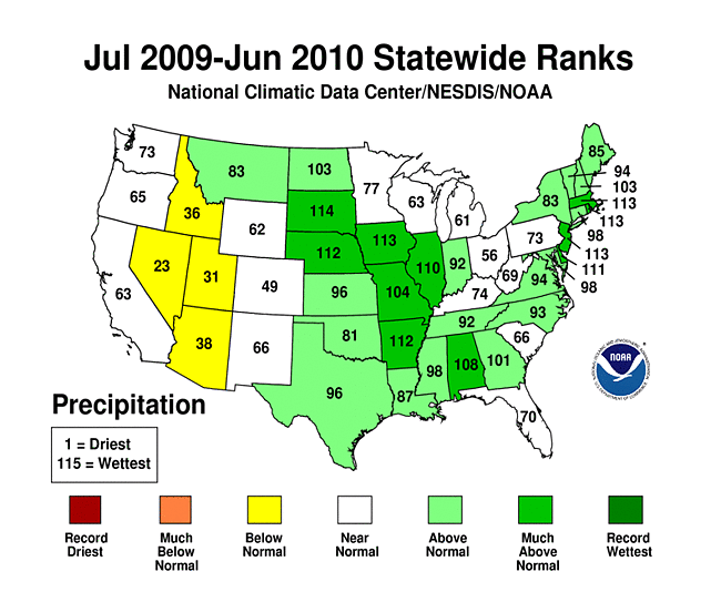
On a statewide basis, June 2010 was drier than normal for states in the mid-Atlantic and Southeast and for a couple in the West. Maryland ranked sixth driest and Virginia eleventh driest. The last three months (April-June 2010) were drier than normal for several states along the Atlantic seaboard, in the Lower Mississippi Valley, and a few in the West. Maryland (seventh driest), Delaware (ninth driest), and New Jersey (tenth driest) all ranked in the top ten driest category, with Connecticut and Virginia ranking eleventh driest and Louisiana twelfth driest. Louisiana also had the sixth driest year-to-date, with several other states from the Southeast to the mid-Atlantic drier than normal for January-June 2010. The last twelve months (July 2009-June 2010) ranked drier than normal for four states in the interior West.
The dryness was exacerbated by increased evaporation associated with unusually hot temperatures in many southern and eastern states. Delaware, New Jersey, and North Carolina each had the warmest June on record, with many stations in the South and East setting new daily maximum temperature records. Eleven states, from Louisiana to Maine, had the warmest April-June in the 116-year record. Even the last six months (January-June 2010) was the warmest such year-to-date on record for four New England states.
 |
 |
Abnormal dryness and drought were evident in several indicators. Much of the Southwest and parts of the southern Plains and mid-Atlantic states had just a few days with precipitation during June 2010. The dry spell in the Southwest lasted most of the month, while dry spells lasted two weeks or longer in parts of the southern Plains and mid-Atlantic states. Soil moisture, as observed (percent of topsoil dry and very dry, and comparison to 5-year average and 10-year average) and as monitored by several models (NOAA Climate Prediction Center anomalies and percentiles, Leaky Bucket, NLDAS [North American Land Data Assimilation System] top soil layer and total soil layer), was drier than average across much of the country from New England to the Lower Mississippi Valley, much of Alaska, and parts of the Southwest and Hawaii. According to July 4th U.S. Department of Agriculture (USDA) reports, half or more of the topsoil moisture was rated very dry (short to very short) in New Mexico, Arkansas, Mississippi, Tennessee, North Carolina, Virginia, West Virginia, Maryland, Delaware, Pennsylvania, New Jersey, Connecticut, Rhode Island, Massachusetts, and New Hampshire. An epicenter of worst soil moisture conditions was the mid-Atlantic, where 80 percent or more of the topsoil was rated very dry in Virginia (83 percent), Maryland (85 percent), and Delaware (87 percent).

Vegetation Drought Response Index (VegDRI), June 28, 2010.
Rainfall was spotty, but persistently hot temperatures, with daily highs in the 90s and 100s °F, led to heat stress in some crops in the Southeast by the end of the month. Hot weather (90-plus °F daily highs) combined with continuing low precipitation to dry soils and halt grass and pasture growth in the mid-Atlantic states. These impacts are reflected in the weekly Palmer Crop Moisture Index (CMI), which was developed to assess moisture conditions as they specifically relate to crops, and in other indicators. The end of June CMI showed excessively dry conditions along the mid-Atlantic coast and Lower Mississippi Valley. Satellite monitoring of vegetation health (Vegetation Drought Response Index, Vegetation Health Index) revealed stress on vegetation along the Great Lakes, Ohio Valley, Lower Mississippi Valley, and parts of Alaska, with lingering stress in parts of the West. The U.S. Geological Survey (USGS) agro-hydrologic model (Soil Water Index, Water Requirement Satisfaction Index) indicated stress on vegetation along the Atlantic seaboard and across the South, with severe stress in the Southwest. The impacts were showing up on the pastures and rangeland in the mid-Atlantic states where, according to July 4th USDA reports, nearly half or more of the pastures and rangeland were in "poor" or "very poor" condition in Virginia and Delaware. On a national scale, 65 percent of the nation's rangeland and pastures were rated in good to excellent condition (compared to 69 percent last month), while eleven percent were rated poor to very poor (compared to seven percent last month). By early July, however, row-crop conditions were equal to or better than this time last year for all major U.S. commodities, including corn (71 percent good to excellent on July 4th), sorghum (71 percent), soybeans (66 percent), winter wheat (63 percent), spring wheat (83 percent), rice (72 percent), peanuts (72 percent), and cotton (65 percent).
Well monitoring stations (real-time network, climate response network, total active network) showed low groundwater across parts of the Southwest and mid-Atlantic regions. Streamflow (observed and modeled [CPC, VIC]) was below average in the western Great Lakes, across parts of the Atlantic seaboard to Lower Mississippi Valley, parts of the West, and much of Hawaii.

Percent area of the Western U.S. in moderate to extreme drought, January 1900-June 2010, based on the Palmer Drought Index.
October through the following September is defined as the water year for the West. The water-year-to-date (October-June) precipitation pattern has been mixed at both the low elevation stations and high elevation (SNOTEL network) stations. The late-season snow water content pattern was below-average at most locations (WRCC depiction, USDA depiction), but this is late in the snow season so long-term baseline averages ("normals") are low to begin with. Winter and spring mountain snowpack provides a crucial water source for the summer melt season across much of the West. An analysis by the USDA indicated that reservoir levels were generally below average across much of the interior basins. According to the USDM, eleven percent of the West was experiencing moderate to severe drought at the end of June, a decrease from May, while the Palmer Drought Index statistic rose to eight percent.
As noted by the Southeast Regional Climate Center, June was an exceptionally warm month with generally below normal precipitation across the Southeast owing to a deep ridge of high pressure that remained anchored over the region for most of the month. However, localized areas that experienced more thunderstorm activity had near normal or slightly above normal precipitation. Rainfall totals were less than 50 percent of normal across broad portions of Virginia, while precipitation totals in the northern and southeast parts of the state were less than 25 percent of normal. Clarksville, Virginia received 0.65 inches (16.5 mm) of precipitation for the month, which was only 16 percent of normal. Outside of Virginia, the driest locations across the Southeast (less than 25 percent of normal) were along the immediate coast from the Outer Banks of North Carolina to the southern tip of Florida, east-central Alabama, and northwest South Carolina. The 2010 calendar year continued to be exceptionally wet across Puerto Rico; monthly precipitation totals were over 200 percent of normal along the southern end of the island in June. Mean temperatures ranged from 2 °F above normal along the Florida Panhandle to over 7 °F above normal across central North Carolina and Virginia. Mean temperatures for the month were near normal across Puerto Rico. Over 60 locations in the Southeast experienced their warmest June on record. There were over 1,000 record daily high minimum temperatures tied or broken across the region. Despite the lack of rainfall across much of the Southeast, there were no areas displaying drought conditions (D1 or greater) during June. By the end of the month, abnormally dry (D0) conditions had developed throughout much of Virginia, northeast North Carolina, and northwest South Carolina where precipitation deficits were the greatest. Abnormally dry conditions also developed in the mountains of North Carolina.
As explained by the Southern Regional Climate Center, June precipitation totals in the Southern Region varied dramatically from state to state, and from climate division to climate division. The majority of the stations in the region reported values for the month that varied between 70 and 110 percent of normal. Relative to the monthly normals, the wettest areas of the region occurred in eastern Oklahoma, where many stations recorded between 150 to 200 percent of normal. Similar values were also observed in east central Texas, western Texas and southwestern Louisiana. The driest location within the region was eastern Arkansas, where most stations reported less than half the monthly allotment. There were many similar pockets of dryness in: western Oklahoma, Southern Texas, and northwestern Mississippi. It was a generally warm June for much of the Southern Region. In total, the six states combined had a monthly average temperature of 81.95 °F (27.8 °C), making it the fourth warmest June on record (1895-2010) for the entire region.
Drought conditions in the Southern Region significantly changed during June. Areal coverage of moderate drought or worse increased from 12 percent to 14.1 percent. New drought locations included north central Texas, southern Arkansas, and the northwestern Mississippi border. In addition, conditions worsened in northern Louisiana, which now had extreme drought (D3) conditions. The D3 area made up 1.5 percent of the Southern Region and 16.8 percent of the state of Louisiana.
As summarized by the Northeast Regional Climate Center, rainfall in the Northeast averaged above normal in June; however, the totals were quite variable, with above normal rainfall in the west and north and dry conditions in the southeastern third of the region. The regional total was 4.30 inches (109 mm) and this was 106 percent of normal. Vermont, Maine and New York were the wettest states, with 141, 136 and 131 percent of normal rainfall, respectively. It was the 13th wettest June since 1895 in Vermont and New York and the 15th wettest in Maine. Maryland, on the other hand, had its 6th driest June in 116 years with only 53 percent of the normal rainfall amount. Four consecutive months of below normal precipitation in Pennsylvania and three consecutive drier than normal months in Connecticut, Delaware, Maryland, Massachusetts and New Jersey have resulted in some drought concerns as of June 29, 2010. According to the USDM of that date, all of New Jersey and Delaware, parts of southern New York, eastern and southern Pennsylvania, eastern West Virginia and most of Maryland were abnormally dry, while the southernmost part of Maryland was under moderate drought conditions.
June 2010 was the 6th consecutive month with above normal temperatures in the Northeast and the 18th warmest June in 116 years. The region averaged 67.3 °F (19.6 °C), which was 2.2 °F (1.2 °C) above normal. Departures increased from north to south and ranged from 0.3 °F (0.2 °C) below normal in Vermont to 5.8 °F (3.2 °C) above normal in Delaware. It was the warmest June since 1895 in Delaware and New Jersey, the 2nd warmest in Maryland, the 4th warmest in Rhode Island and the 5th warmest in West Virginia.
As noted by the Western Regional Climate Center, precipitation was well above normal in the Pacific Northwest, near normal in the Intermountain and very low in the Southwest. A new record June rainfall total of 4.27 inches (108.5 mm) fell in Portland, Oregon. It was the wettest June in Billings, Montana, since 1991. One exception in the dry Southwest was Roswell, New Mexico. Their total of 4.21 inches (107 mm) was the most in June since 1986. An unusually strong late season rain event hit northwest California and southwest Oregon early in the month leading to the wettest June in over 70 years in some locations. Temperatures throughout the West were 1 to 4 °F (0.5 to 2.5 °C) below normal in the northern tier with the Northwest having the coolest temperatures. In the southern portions of the West, temperatures were generally 1 to 4 °F (0.5 to 2.5 °C) above normal with portions of New Mexico having the greatest positive departures. Significant wildfires occurred in Arizona and New Mexico. The Schultz fire north of Flagstaff, Arizona, was started by an abandoned campfire and quickly spread due to very dry, hot and windy conditions. As of June 30th, the fire was 90 percent contained and had burned over 15,000 acres. Luckily, no homes were destroyed. The South Fork Fire, near Los Alamos, New Mexico, was caused by lightning on June 10th and had burned over 17,000 acres by the 30th with only 50 percent containment. Again, no structures were burned.
As explained by the High Plains Regional Climate Center, June 2010 was a wet month for much of the High Plains Region as a large swath extending from Wyoming, into Nebraska, and South Dakota received over 200 percent of normal precipitation. The heavy rains led to flooding along many rivers and also in fields. However, June brought only minor changes to the High Plains Region depiction on the U.S. Drought Monitor. North Dakota, South Dakota, Nebraska, and Kansas remained drought free this month, but little to no precipitation fell in southern Colorado which led to the development of abnormally dry conditions (D0). D0 in northern Colorado persisted and D0 and moderate drought conditions (D1) in western Wyoming remained largely unchanged during June. However, in the northwest corner of Wyoming, the severe drought conditions (D2) were downgraded to D1 and D0.
As summarized by the Midwest Regional Climate Center, June precipitation was above normal for most of the Midwest. Only southern Missouri, western and central Kentucky, extreme northeast Ohio, and parts of northwest Minnesota saw below normal precipitation. Only southern Missouri received less than 75 percent of normal with southeast Missouri the driest as some locations got less than a quarter inch (6 mm) for the month. On the other hand, parts of several states got at least twice their normal rainfall. The June rains improved drought conditions in the Upper Midwest. Multi-year precipitation deficits and the low lake levels they caused remained but the shorter-term conditions were much improved.
[top]
State/Regional/National Moisture Status
A detailed review of drought and moisture conditions is available for all contiguous U.S. states, the nine standard regions, and the nation (contiguous U.S.):
| northeast u. s. | east north central u. s. | central u. s. |
| southeast u. s. | west north central u. s. | south u. s. |
| southwest u. s. | northwest u. s. | west u. s. |
| Contiguous United States |
[top]
Drought Indicators
- Palmer Drought Indices
- Standardized Precipitation Index
- long-term (36 to 60 month) percent of normal precipitation maps
- airport station percent of normal precipitation maps
- statewide precipitation rank maps
- Cooperative station percent of normal precipitation maps
- percent of average maps for the SNOTEL stations in the western mountains provided by the Western Regional Climate Center
- hydrologic year precipitation
- snow water equivalent of snowpack
- satellite-based observations of vegetative health
- National Weather Service model calculations of soil moisture, runoff, and evaporation
- National Weather Service model calculations of soil moisture using the Leaky Bucket Model
- Midwest Regional Climate Center model calculations of soil moisture
- topsoil moisture conditions observed by the USDA and mapped by the Climate Prediction Center
- pasture and range land conditions observed by the USDA and mapped by the Climate Prediction Center
- streamflow maps maintained by the USGS
[top]
Contacts & Questions