|
Contents Of This Report: |

|
National Drought Overview
|
|
[top]
Detailed Drought Discussion
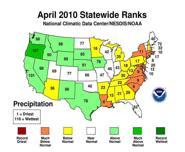
April 2010 was drier and warmer than normal when weather conditions are averaged across the country, with the national precipitation ranking in the bottom one-third of the historical distribution (36th driest). But considerable variability occurred throughout the month (weeks 1, 2, 3, 4, 5) and on a regional basis. Beneficial rain and snow fell across parts of the West, while parts of the Southwest, the western Great Lakes, and much of the country along and east of the Mississippi River was drier than normal. The dryness was especially severe from the Great Lakes to Mid-Atlantic States. By the end of April, drought or abnormally dry areas expanded in the East. In the Hawaiian Islands, drought intensified on Molokai, reflecting worsening pasture conditions, but the moderate to exceptional drought area decreased slightly for the islands as a whole.

The U.S. Drought Monitor drought map valid April 27th, 2010.
The  weather pattern for April was dominated by frequent upper-level ridging in the eastern United States and troughs in the West. Pacific weather systems brought generally cooler-than-normal temperatures and areas of above-normal precipitation to the West. Although weather systems occasionally pushed through the ridge to bring areas of rain to the East, warm and dry conditions dominated east of the Mississippi.
By the end of April, core drought areas in the U.S. included:
- parts of Hawaii, where moderate (D1) to exceptional (D4) drought persisted;
- parts of the West, High Plains, and Upper Mississippi Valley, which had areas of moderate (D1) to severe (D2) drought; and
- parts of the East and South, where areas of moderate drought had developed.
|
 |
The Palmer drought indices measure the balance between moisture demand (evapotranspiration driven by temperature) and moisture supply (precipitation). The Palmer Z Index depicts moisture conditions for the current month, while the Palmer Hydrological Drought Index (PHDI) and Palmer Drought Severity Index (PDSI) depict the current month's cumulative moisture conditions integrated over the last several months. Unusually dry conditions were evident on the April 2010 Palmer Z Index map over much of the country east of the Mississippi River, and across parts of the southern Plains. The April 2010 PHDI map indicates that the drought conditions over the Great Lakes and West were due to long-term dryness, whereas the southern Plains to eastern seaboard dry conditions were a recent development.
 |
 |
 |
The Standardized Precipitation Index (SPI) measures moisture supply. The six SPI maps here show the spatial extent of anomalously wet and dry areas at time scales ranging from one month to 24 months. With the exception of Florida, the coastal Southeast (Louisiana to the Carolinas) shows significant precipitation departures for the last three months. Dry conditions are evident on the maps from one month to six months for an area stretching from the southern Mississippi Valley to the Ohio Valley and into the eastern Great Lakes. Parts of the western Great Lakes have been drier than normal at all time scales. While April was wetter than normal for large parts of the West, the northern Rockies have dry anomalies for the last 2 to 3 months out to 12 to 24 months.
 |
 |
 |
Did You Know?
Water Supply vs. Water Demand
It is important for drought indices to have a term for water demand (evaporation or evapotranspiration, ET) as well as water supply (precipitation). Drought indices like the Standardized Precipitation Index (SPI) or precipitation percentiles measure only water supply, while indices like the Palmer Drought Index incorporate a balance between water supply and water demand. Indices that measure just water supply tell only part of the story. Indices that are based on the hydrological balance between water supply and water demand give a more complete picture. Water supply is easy to measure -- it is just precipitation, maybe with some component that looks at soil moisture. Water demand is harder to calculate and is frequently based on temperature. Warmer temperatures generally result in more ET and greater water demand, increasing the risk of drought.
In Hawaii, the percent area of the state in moderate to exceptional (D1-D4) drought shrank from 57 percent at the end of March to 51 percent by the end of April. However, April 2010 was drier than normal at many stations in the islands and continued a trend of drier-than-normal weather which has lasted for at least the last three to 12 to 24 to even 36 months. The National Weather Service reported that portions of the state have had the driest wet season (October-March) in 30 years. According to the U.S. Department of Agriculture (USDA), crops were in fair condition but required much irrigation. Pastures, especially in leeward areas, continued to deteriorate. Voluntary irrigation water use reductions remained in effect in Maui and Honolulu Counties. Worsening pasture conditions resulted in the expansion of drought on Molokai. Streamflow across the islands averaged near normal.
The precipitation pattern across Alaska was mixed for April 2010. However, drier-than-normal conditions have prevailed for most stations for the last 3 to 6 to at least 12 months. Some stations in south central Alaska have dry anomalies for the last 24 to 36 months. Precipitation for the hydrologic year (October to the following September) to date in central Alaska has been especially dry, as reflected by end-of-April snowpack (SNOTEL snow water content, snow course observations).
Precipitation anomalies varied across Puerto Rico during April 2010 and the year to date. The southeast part of the island had below-normal rainfall for the water year to date (October 1-May 5). But streamflow averaged above normal for the month island-wide.

Michigan statewide precipitation, year-to-date (Jan-Apr), 1895-2010.
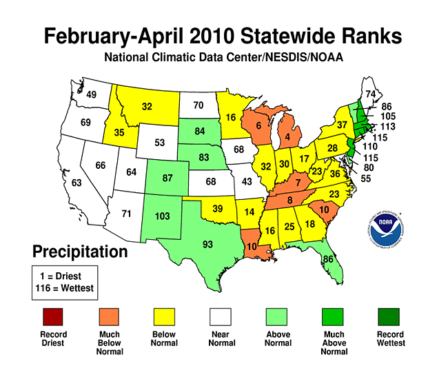
On a statewide basis, April 2010 was the tenth driest, or drier, April in the 1895-2010 record for Louisiana (sixth driest) and six states along the eastern seaboard (South Carolina [sixth driest], Connecticut [eighth driest], North Carolina [ninth driest], Virginia [ninth driest], Maryland [tenth driest], Massachusetts [tenth driest]). The last three months (February-April 2010) were among the ten driest February-April's on record for several states along and east of the Mississippi River (Michigan [fourth driest], Wisconsin [sixth driest], Kentucky [seventh driest], Tennessee [eighth driest], Louisiana [tenth driest], South Carolina [tenth driest]). Michigan had the second driest year-to-date (January-April 2010). The last six months (November 2009-April 2010) were third driest for Kentucky and Michigan and eighth driest for Ohio.
![South Carolina [sixth driest]](/sotc/service/national/timeseries01/038-00/201004-201004.gif)
![Connecticut [eighth driest]](/sotc/service/national/timeseries01/006-00/201004-201004.gif)
![North Carolina [ninth driest]](/sotc/service/national/timeseries01/031-00/201004-201004.gif)
![Virginia [ninth driest]](/sotc/service/national/timeseries01/044-00/201004-201004.gif)
![Maryland [tenth driest]](/sotc/service/national/timeseries01/018-00/201004-201004.gif)
![Massachusetts [tenth driest]](/sotc/service/national/timeseries01/019-00/201004-201004.gif)
![Michigan [fourth driest]](/sotc/service/national/timeseries01/020-00/201002-201004.gif)
![Wisconsin [sixth driest]](/sotc/service/national/timeseries01/047-00/201002-201004.gif)
![Kentucky [seventh driest]](/sotc/service/national/timeseries01/015-00/201002-201004.gif)
![Tennessee [eighth driest]](/sotc/service/national/timeseries01/040-00/201002-201004.gif)
![Louisiana [tenth driest]](/sotc/service/national/timeseries01/016-00/201002-201004.gif)
![South Carolina [tenth driest]](/sotc/service/national/timeseries01/038-00/201002-201004.gif)
The area around Lake Superior and northern Lake Michigan had record or near-record dryness during the last three months. February-April 2010 was the driest such three-month period in the 1895-2010 record for portions of northern Wisconsin (climate division 2) and northern Michigan (divisions 1, 2, 3).

NLDAS Model total column soil moisture percentile, April 29, 2010.
Abnormal dryness and drought were evident in several indicators. The Southwest and parts of the Southeast had just a few days with precipitation during April 2010. The dryness in parts of these regions, as well as the northwest Great Lakes, lasted two consecutive weeks or longer. Soil moisture, as observed (percent of topsoil dry and very dry, and comparison to 5-year average and 10-year average) and as monitored by several models (NOAA Climate Prediction Center anomalies and percentiles, NLDAS [North American Land Data Assimilation System] top soil layer and total soil layer), was drier than average across much of the Great Lakes to Mid-Atlantic States, Louisiana, and parts of the West.
Satellite monitoring of vegetation health (Vegetation Drought Response Index, Vegetation Health Index) indicated lingering stress on vegetation in parts of the West and developing stress in parts of the East. USDA pasture and rangeland condition reports (percent in "poor" or "very poor" condition, anomaly) revealed just a few states with deteriorating (above average percent in "poor" or "very poor") conditions. According to the USDA, U.S. corn planting reached the halfway mark on the earliest date on record this year, with information available from 1974 to 2010. Fifty percent of the nation's corn was planted by April 25th. The previous record for April 25 was 37 percent in 2004. While the warm and dry weather of the last several weeks, following very wet fall and winter months, was beneficial for fieldwork and planting of crops in some midwestern and northern locations, the lack of rain was beginning to take its toll on small grains, pastures, and newly planted crops in parts of the Southeast. Well monitoring stations (real-time network, climate response network, total active network) had sporadic reports of low groundwater in parts of the West, Great Lakes, and East. Streamflow (both observed and modeled) was below average across much of the Great Lakes and Ohio Valley, and parts of the West and South.

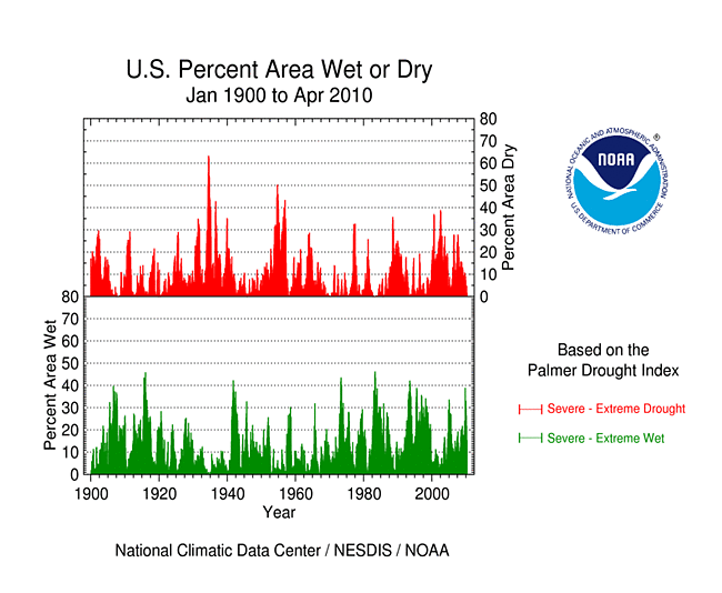
Percent area of the Western U.S. in moderate to extreme drought, January 1900-April 2010, based on the Palmer Drought Index.
October through the following September is defined as the water year for the West. Water-year-to-date (October-April) precipitation has been mixed at low elevation stations, but a spatial pattern of above-average conditions in the southern portions of the West and below-average conditions in the northern portions is evident at high elevation (SNOTEL network) stations. This pattern (of much heavier precipitation in the southern compared with the northern West) is very characteristic of El Niño years. The pattern was more evident in the high-elevation maps of the end-of-April snowpack and snow water content. Winter and spring mountain snowpack provides a crucial water source for the summer melt season across much of the West. An analysis by the USDA indicated that reservoir levels were generally below average across much of the interior basins. According to the USDM, 19 percent of the West was experiencing moderate to severe drought at the end of April, which was about the same as the value for March, while the Palmer Drought Index statistic was 14 percent.
As noted by the Midwest Regional Climate Center, April precipitation was below normal for most of the Midwest. For southern Missouri to Michigan and areas to the southeast, totals were generally below normal with southeast Ohio receiving less than 50 percent of normal. Another swath of below-normal precipitation extended form northwest Iowa, across most of Minnesota, northern Wisconsin, and the Upper Peninsula of Michigan. Near Lake Superior, totals were less than 50 percent of normal with the northeast tip of Minnesota getting less than 25 percent of normal. Above-normal rains fell in northern Missouri, southwest Iowa, northwest Illinois, southern Wisconsin, and the Red River Valley in northwest Minnesota.
Minnesota recorded its first April with no measurable snow since at least 1891 when modern records began. Duluth reported just a trace of snow on the 7th of April. The snowless April followed a nearly snowless March when just a couple stations reported measureable snow on one or two days. Duluth, Minnesota reported no measureable snow in March or April with just a trace on one day each month.
Corn planting proceeded on a record pace with 50 percent of the nationwide crop planted by April 25th. The previous high was 37 percent since 1974 when records began. Midwest states were also at record paces with planting going very quickly, especially in the latter half of April. As of April 25th, Kentucky had 74 percent of its corn planted, Illinois 73 percent, Missouri 69 percent, Iowa 68 percent, Minnesota 63 percent, Indiana 56 percent, Ohio 45 percent, Michigan 32 percent, and Wisconsin 20 percent. Wisconsin was 13 percent ahead of the past 5-year average; Kentucky, Ohio, Michigan, and Missouri were 20 percent to 40 percent ahead of the average; and Iowa, Illinois, Indiana, and Minnesota were more than 40 percent ahead of the average.
As summarized by the High Plains Regional Climate Center, precipitation varied across the region this month. While western Wyoming received above normal precipitation in April 2010, it was not enough to make a dent in the ongoing drought conditions. Abnormally dry conditions (D0) developed in central Kansas and also spread from Montana east into the northwest corner of North Dakota. Both areas have experienced below normal precipitation over the past few months. The drought conditions in Colorado and Wyoming remained largely unchanged from last month.
As explained by the Southern Regional Climate Center, monthly precipitation totals for the month of April were quite variable over the Southern Region. The highest negative precipitation anomalies were observed in central and southern Louisiana, where most stations reported less than one quarter of the monthly normal. Similar values were also observed in southwestern Mississippi and southeastern Texas. The state of Louisiana reported a state-wide average precipitation value of 1.23 inches (31.24 mm), which was the sixth driest April on record (1895-2010). Mississippi reported a state-wide average precipitation of 2.71 inches (68.83 mm), which was the 15th driest April on record (1895-2010). In contrast, conditions were quite wet in the western half of Texas, with many stations reporting more than 200 percent of normal precipitation. Elsewhere in the region, most stations reported slightly below normal precipitation for the month. Precipitation values generally ranged from 50 to 75 percent of normal. After nine consecutive weeks of the Southern Region being completely drought-free, a small area of moderate (D1) drought was introduced in northeastern Louisiana. The drought level was declared on the April 20, 2010 United States Drought Monitor map and persisted to the end of the month. The area of D1 drought made up 1.3 percent of area of the Southern Region and 11.92 percent of the area of Louisiana.
As noted by the Southeast Regional Climate Center, continuing the trend from March, precipitation totals for April 2010 were below normal across most of the region. In general, precipitation totals were between 50 and 75 percent of normal across Virginia, North and South Carolina, and much of Georgia and Alabama. Precipitation was close to normal across Puerto Rico. In contrast, monthly precipitation across the southern half of Florida was between 200 to more than 300 percent of normal. Additionally, narrow swaths of above-normal precipitation (100-150 percent) were recorded in Georgia and Alabama. Much of this precipitation was connected with a series of strong thunderstorms that tracked across the region on the 25th of the month. In other parts of the Southeast, monthly precipitation totals were well below normal (5-25 percent). These areas included southwest Alabama, northeast Florida, and much of the coastal Carolinas. Federal Point, Florida, located near St. Augustine, recorded only 0.20 inch (5.08 mm) of precipitation, which was 9 percent of normal for the month. Charleston International Airport in South Carolina experienced the fifth driest April in a record extending to 1938, with only 0.70 inch (17.78 mm) of precipitation. It was the driest April in New Bern and Lumberton, North Carolina, according to records extending back to 1948 at both stations. Drought conditions returned to the Southeast region in April, which had been drought-free since January. A small area of abnormal dryness (D0) developed in southern Alabama and extreme western Florida early in the month. By the end of the month, abnormally dry conditions had developed in northern Alabama as well as through central and eastern regions of the Carolinas where precipitation deficits were the greatest.
As summarized by the Northeast Regional Climate Center, April 2010 was the second month in a row that the average temperature for the region ranked among the top ten warmest since 1895. The weather pattern that kept the Northeast warm in April also kept it dry. The region's precipitation total was 2.19 inches (55.6 mm), which was 61 percent of normal. It was the Northeast's 13th driest April since recordkeeping began in 1895. Two months of below normal precipitation in western portions of the region led to drought concerns as the growing season began. According to the April 27, 2010 USDM, the region had two areas in moderate drought — the New York counties at the east end of Lake Ontario and northwest Pennsylvania. A larger area, stretching from northern New York to western Pennsylvania and into northern West Virginia, was experiencing abnormally dry conditions.
[top]
State/Regional/National Moisture Status
A detailed review of drought and moisture conditions is available for all contiguous U.S. states, the nine standard regions, and the nation (contiguous U.S.):
| northeast u. s. | east north central u. s. | central u. s. |
| southeast u. s. | west north central u. s. | south u. s. |
| southwest u. s. | northwest u. s. | west u. s. |
| Contiguous United States |
[top]
Drought Indicators
- Palmer Drought Indices
- Standardized Precipitation Index
- long-term (36 to 60 month) percent of normal precipitation maps
- airport station percent of normal precipitation maps
- statewide precipitation rank maps
- Cooperative station percent of normal precipitation maps
- percent of average maps for the SNOTEL stations in the western mountains provided by the Western Regional Climate Center
- hydrologic year precipitation
- snow water equivalent of snowpack
- satellite-based observations of vegetative health
- National Weather Service model calculations of soil moisture, runoff, and evaporation
- National Weather Service model calculations of soil moisture using the Leaky Bucket Model
- Midwest Regional Climate Center model calculations of soil moisture
- topsoil moisture conditions observed by the USDA and mapped by the Climate Prediction Center
- pasture and range land conditions observed by the USDA and mapped by the Climate Prediction Center
- streamflow maps maintained by the USGS
[top]
Contacts & Questions