| Contents Of This Report: |
 |

|

|
|
|
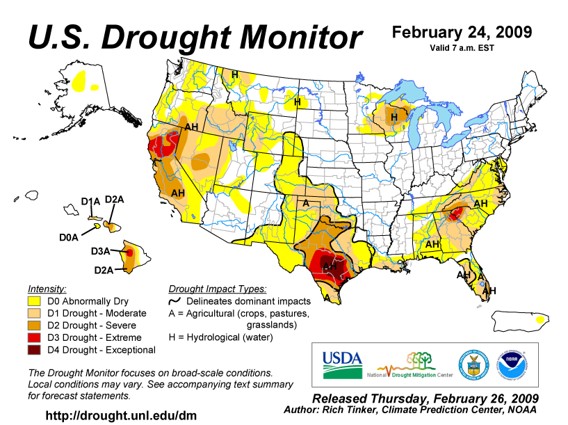
The
 weather pattern
for the beginning of February was dominated by
an upper-level
high pressure ridge over the western U.S. and an upper-air
trough over the East. Several Pacific weather systems were able to
break through the western ridge, bringing abundant
moisture to parts of the region, especially California.
East of the Rockies, the dominant upper-air flow generally cut off
the Gulf of Mexico moisture supply. Several cold fronts and weather
systems moved across the central and eastern U.S. during the month,
but moisture surpluses were mainly limited to the northern
Plains and Great Lakes regions where most of the low pressure
centers tracked. The upper-air jet stream flattened into a
generally zonal flow by the end of the month. As a result, drought
conditions improved slightly in the Southwest but intensified in
the southern Plains and Southeast (February 24
USDM versus January 27
USDM). weather pattern
for the beginning of February was dominated by
an upper-level
high pressure ridge over the western U.S. and an upper-air
trough over the East. Several Pacific weather systems were able to
break through the western ridge, bringing abundant
moisture to parts of the region, especially California.
East of the Rockies, the dominant upper-air flow generally cut off
the Gulf of Mexico moisture supply. Several cold fronts and weather
systems moved across the central and eastern U.S. during the month,
but moisture surpluses were mainly limited to the northern
Plains and Great Lakes regions where most of the low pressure
centers tracked. The upper-air jet stream flattened into a
generally zonal flow by the end of the month. As a result, drought
conditions improved slightly in the Southwest but intensified in
the southern Plains and Southeast (February 24
USDM versus January 27
USDM). |
 |
 |
| Much of the country
received below-average
precipitation during the month, resulting in the eighth driest
February for the contiguous United States. The
areas with the driest anomalies included the coastal Northeast
to mid-Atlantic states, parts of the Southeast and southern Plains,
and parts of the Rockies to Pacific Northwest. February was drier
than normal across the southern and eastern portions of Puerto
Rico, with the year-to-date drier than normal across the
southeast.
Most of the stations in Hawaii reported below-normal
precipitation in February, resulting in little change to the
drought
areas. Beneficial rains in December improved the 3-month
precipitation totals, but the
last 12 months were generally dry. February
was wet across much of Alaska, but dry along parts of the
southern coast. The precipitation pattern for the last
three months and
last 12 months was mixed. Only a few areas in Alaska had
below-average
snowpack as of the end of February. By the end of February, the core drought areas included:
|
| Soil moisture conditions, as estimated by NASA's Mosaic model (surface layers, deeper layers) and the NOAA Climate Prediction Center, improved in the Southwest but worsened in Florida, compared to a month ago. Surface moisture improved across the West, western Great Lakes/Upper Mississippi Valley, and parts of the Southeast (as measured by the Mosaic model). Streamflow levels (both modeled and observed) decreased in the mid-Atlantic states, Southeast, southern Plains, and Pacific Northwest when compared to a month ago (modeled, observed). Data from the USGS network of wells indicated lingering groundwater impacts across the Southeast, southern Plains, and in a few other areas. The impact of drought on vegetation is normally reduced this time of year due to seasonally colder weather, but the satellite-based Vegetation Health Index indicated stress to vegetation in southern Texas. |
  |
 |
 |
 |
| The dryness in February is a continuation of prolonged dryness in some parts of the country. In the Northeast and mid-Atlantic states, January and February 2009 were dry, but the latter months of 2008 were wet. The recent dryness across parts of the Southeast can be traced back two to four months, while in the southern Plains and parts of the West, it can be traced back 12 months or longer. |
 |
 |
 |
   |
Several states had the
driest February on record (Delaware,
New
Jersey) or ranked in the top ten driest for February (Connecticut,
Maryland,
New
York, North
Carolina, Pennsylvania,
Virginia,
Washington,
West
Virginia, Wyoming). The February dryness extended back into January for most of these states, especially in the Mid-Atlantic and Northeast where Delaware, New Jersey, and Virginia all had the driest January-February on record. January-February 2009 was also dry in several Southeast and southern Plains states, with Georgia, Louisiana, New Mexico, North Carolina, South Carolina, and Texas all ranking in the top ten driest category. For the contiguous U.S., 2009 had the driest January-February in the 1895-2009 record. For winter (December 2008-February 2009), the dryness was especially severe in the southern Plains, where Texas had the driest winter on record, and the Southeast. Florida, Georgia, Louisiana, and Oklahoma all ranked in the top ten driest for winter. Nationally, this winter ranked as the fifth driest on record. |
 |
 |
The drought has impacted
agriculture in the southern Plains and contributed to numerous
wildfires which continued across parts of Texas and into Oklahoma
during February. Based on March 1 USDA reports, top soil moisture
was mostly very short to short (very dry to dry) across the Lone
Star State. The drought ravaged crops, with 85 percent of the oats,
63 percent of the wheat, and 73 percent of the pasture and
rangeland in very poor to poor condition. In Oklahoma, March 2 USDA
statistics indicated that the percent in very poor or poor
condition was greater than 35 percent for several crops: oats
(47%), winter wheat (42%), and rye (36%). Forty percent of pasture
and rangeland was in very poor to poor condition. Areas
particularly hard-hit by moisture shortages include:
|
| Beneficial rain and
snow fell across parts of California
during February, bringing short-term relief. But the precipitation
largely missed the Pacific
Northwest and Rocky
Mountains. As mentioned earlier, Oregon and Wyoming had their
sixth driest February, with all of the Rocky Mountain and Pacific
Northwest states ranking in the "below
normal" category. According to local reports, small lakes and
stock ponds were drying up in eastern Washington state, soil
moisture was very dry, and a decreasing water table has dried out
some irrigation wells. Long-term moisture deficits remained over much of the West. In spite of the February wetness, parts of northern California and northern Nevada had record to near-record dryness for March 2008-February 2009 (last 12 months) and March 2007-February 2009 (last 24 months). March 1 mountain snowpack over California improved compared to February 1, but snowpack and snow water content remained below average across large parts of the West. Reservoir levels were above average in Arizona, Colorado, and Washington, but below average across many other states. According to the Palmer Drought Index, about 56 percent of the region was in moderate to extreme drought at the end of the month, while the USDM estimated the statistics at about 27 percent in moderate to exceptional drought and about 63 percent experiencing abnormally dry to exceptional drought conditions. The differences between the Palmer and USDM statistics are due to the extreme seasonality of precipitation in the West and other hydrologic components in the drought calculations. |
   
|
| A more detailed drought discussion, provided by the NOAA Regional Climate Centers and others, can be found below. |
|
|
|
According to the Southeast Regional Climate Center, February was an exceptionally dry month as monthly precipitation totals were less than 50 percent of normal across most of the region. Precipitation was less than 25 percent of normal across portions of Florida, southern Alabama, and northern Virginia. Washington, DC recorded only 0.35 inch (9 mm) of precipitation for the month, making it the driest February in a record extending back to 1872. Also, much of southern Florida received less than 0.25 inch (6 mm) of precipitation for the month. Most of Puerto Rico experienced below-normal precipitation totals for the month, although Arecibo in the western interior of the island recorded nearly 8.00 inches (203 mm), more than 4 inches above average. Above normal precipitation totals were largely restricted to small portions of north central Alabama, Georgia and central South Carolina. This rainfall provided some short term relief from the drought persisting across portions of the area. Given the persistence of relatively dry weather, drought conditions expanded across the region. Extreme drought conditions continued across northwestern South Carolina and extreme northeast Georgia and regions of severe drought, which were limited to west central Florida in January, expanded to include portions of western North Carolina as well as south Florida. The region of moderate drought expanded considerably to include much of western Virginia, western North Carolina and South Carolina as well as large portions of Georgia and Florida. The extreme winter dryness across south Florida has left the vegetation extremely vulnerable to wildfire. As noted by the Southern Regional Climate Center, the Southern Region experienced a second consecutive dry month. The driest areas included southern Texas, the western Texas panhandle, northern Louisiana, southern Arkansas, and parts of central Oklahoma. Total precipitation averaged below 50 percent of normal in those areas. The persistent dry pattern in southern Texas led to further expansion of drought conditions. Over the past month, more areas of the Texas and Oklahoma panhandles deteriorated to moderate drought. Exceptional drought expanded to the central Texas coastline. There was also an eastern expansion of moderate drought in east central Texas. Dry conditions led to moderate drought in the southern Louisiana parishes and Mississippi gulf coastline. Texas: Numerous wildfires burned across parts of Texas and eastern Oklahoma during February. As reported in the Southwest Farm Press (3/5), the Texas AgriLife Extension Service and the Texas Forest Service described major fire activity in counties affected by the prolonged drought. Rich Hirsch, AgriLife Extension agent for agriculture and natural resources, said, "Things are so dry and the humidity so low that when something does start, it just takes off. It's unbelievable how fast it can spread." Taylor County Judge George Newman declared the county a disaster area on March 2 due to wildfires (Abilene Reporter News, 3/2). "It is a tinderbox out there because of the drought conditions," Newman said. As explained by the Midwest Regional Climate Center, precipitation was near to above normal across much of the region. As noted by the High Plains Regional Climate Center, substantial precipitation fell across the Dakotas and west-central Nebraska, with improvement in moderate drought conditions over southwestern North Dakota. However, moderate drought conditions developed in southeastern Kansas and drought conditions persisted across southwestern Wyoming and southeastern Colorado. Kansas: As described by the Kansas Water Office, February 2009 was the fourth consecutive dry month on a statewide basis, with an average total precipitation of 0.50 inch. Several locations reported no precipitation during the month. Nearly the entire state has received less than 70 percent of normal precipitation over the winter (December-February), with much of the southwest receiving less than 25 percent of normal. Moderate Drought was depicted by the U.S. Drought Monitor in 20 southwest or south central Kansas counties. The Cimarron National Grassland in Morton County reported extensive soil erosion due to wind and drought-killed grass. Some 10,000 acres out of a total of 108,000 acres have been blown-out. In some places, only sagebrush and yucca were left to hold the soil. Major wildfires have been reported from nine Kansas counties in 2009, well above the number expected at this time of year. Dry, heavy fuel loadings were a contributing factor. As summarized by the Western Regional Climate Center, a parade of storms affected California beginning on the 5th and continuing to the end of the month. Total rainfall amounts exceeded 20 inches (508 mm) in some locations and helped put a small dent in the serious drought conditions plaguing the state. The February rainfall in Redding of 8.94 inches (227 mm) totaled more than the previous four months combined. Otherwise, conditions were dry throughout the West. Although Shasta Reservoir in northern California rose 35 feet from the beginning of the month to the end, lake level was still well below normal. The Intermountain West was extremely dry. Albuquerque, New Mexico, has not recorded any measurable precipitation yet for 2009 while Denver, Colorado has had only 0.17 inch (4.3 mm) for the year so far (18 percent of normal). It was the first February in Denver back to 1949 where no measurable snow fell. In Lander, Wyoming, it was only the second February on record dating back to 1948 with no measurable precipitation. Along the Washington coast, Quillayute had their second driest February in 43 years. Juneau, Alaska, however continued with their snowy winter as another 30 inches (76 cm) of snow fell giving them 146 inches (371 cm) for the year. Their annual average snowfall is 90 inches (229 cm). Mountain snowpack at the end of the month remained near or slightly above normal for the Southwest and Intermountain West, but the coastal states were between 70 and 80 percent of normal. California snowpack was still only 70-75 percent of normal even after a very wet month. California: As noted by the California State Climatologist (Michael Anderson), mandatory water rationing was announced in several California local water districts, including San Juan, Sacramento, Placer, and Sonoma counties. On February 19, the Monterey County Director of Environmental Health said that he was getting frequent reports of problems with water supply from wells. Mandatory water conservation measures have been implemented in 18 local agencies, and 57 agencies have implemented general voluntary conservation goals, programs, incentivized pricing or restrictions on water deliveries. California governor Arnold Schwarzenegger declared a state of emergency on February 27 because of three years of below-average rain and snowfall in the state (AP 2/27, E&E News PM 2/27). According to media reports, the governor said, "This drought is having a devastating impact on our people, our communities, our economy and our environment, making today's action absolutely necessary." The emergency declaration is a step that urges urban water agencies to reduce water use by 20 percent. Gov. Schwarzenegger declared a statewide drought in June but stopped short of calling a state of emergency then. On February 26, Secretary of the Interior Ken Salazar and Agriculture Secretary Tom Vilsack announced the creation of a Federal Drought Action Team that will work cooperatively to respond to communities facing significant drought (USDA, 2/26). With California currently facing one of its worst droughts in decades, the Drought Action Team will work with Governor Schwarzenegger's state drought response team to minimize the social, economic, and environmental impacts of the current drought. The announcement followed a February 20 announcement by the Department of the Interior's Bureau of Reclamation that, based on water forecasts, initial Water Year (WY) 2009 allocations for the Federal Central Valley Project (CVP) will be significantly limited for agricultural, municipal, industrial, and environmental uses. As noted by the Northeast Regional Climate Center, the region received only 58 percent of its normal monthly precipitation amount, making February 2009 the seventh driest since 1895. Delaware and New Jersey had their driest February in 115 years. Delaware's total of 0.30 inch (12.7 mm) was only 9 percent of normal. States that fell within the ten driest since 1895 were Connecticut (6th), Maryland (6th), New York (8th), and Pennsylvania (10th). None of the states in the region received above-normal precipitation; however, the three northernmost states had totals that approached normal: New Hampshire (76 percent), Maine (86 percent), and Vermont (97 percent). The Northeast's average precipitation total was 1.57 inches (39.9 mm). Unlike last month, snow totals were generally near or below normal. Only Maine ended up with more than the average February snowfall, thanks in part to storms from the 20th to 24th that blanketed much of the state with 1 to 2 feet (30-60 cm) of new snow. Once again this month, portions of Pocohontas, Monroe and Mercer Counties along the West Virginia-Virginia border were in moderate drought when the US Drought Monitor was updated on March 3, 2009. The same report indicated abnormally dry conditions in most of Delaware, southern, central and eastern Maryland and eastern West Virginia along the Virginia border. |
|
| A detailed review of
drought and moisture conditions is available for all contiguous U.S.
states, the nine standard regions, and
the nation (contiguous U.S.): STATES: REGIONS:

|
|