|
Contents Of This Report: |

|
National Drought Overview
|
|
[top]
Detailed Drought Discussion
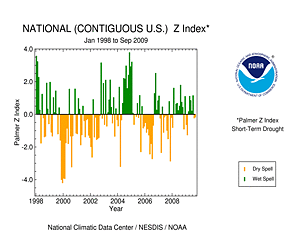
September brought mixed results for drought conditions across the United States. In terms of overall area, drought continued August's modest expansion from a very small early-summer footprint. However, the national coverage of drought's most severe category (D4) retreated dramatically. As of Tuesday September 29th, D4 covered 0.28 percent of the contiguous U.S., less than one-fifth of D4's Spetember 1st footprint.
In central and southern Texas, where the nation's most intense drought episode of 2009 has occurred, short-term conditions improved significantly during September's second week, when "widespread beneficial rains" fell on the region. This resulted in the near-eradication of D4 in the region and a substantial reduction in D3 coverage. Despite the welcome improvements to soil moisture, depressed streamflow continued in the region, indicating that the longer-term hydrologic drought persisted. Moderate rains during late September whittled away at the western extent of Texas drought, but did not substantially help drought conditions in coastal South Texas, where some locations have observed less than half of their normal year-to-date rainfall.
Did You Know?
U.S. Drought Monitor Scale

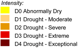
The U.S. Drought Monitor (USDM) established a drought scale much like those that rate hurricanes and tornadoes. The "D-scale" speaks to the "unusualness" of a drought episode. Over the long run, D1 conditions are expected to occur about 10 to 20 percent of the time. D4 is much rarer, expected less than 2 percent of the time. For more detailed information about drought definitions, please visit the U.S. Drought Monitor.
Other areas plagued by drought coming into the month did not improve. In Hawai'i, drought on the southeast tip of the Big Island intensified to D3 . The remainder of the state saw drought conditions persist throughout September. In the Upper Midwest, August improvements were erased by a warm and dry September
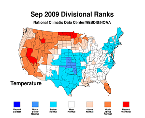
 . A large area of D3 re-emerged in western Wisconsin and near Minnesota's Twin Cities. D2 also spread across the northern half of Wisconsin, into Michigan's Upper Peninsula, and a small part of northern Minnesota. In the West, widespread D1 coverage persisted and expanded into the Four Corners region. D2 coverage remained entrenched across half of California, which observed its warmest September on record and endured a new spate of wildfire activity. The western warmth and dryness extended into the Northwest, where D0 conditions expanded dramatically from Washington and western Oregon into and across the Rocky Mountains of northern Idaho and western Montana.
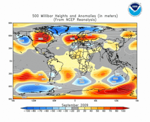
The first three weeks of September were dominated by weak large scale weather patterns across much of the contiguous United States. During this period the jet stream and associated storm track remained largely north of the U.S.-Canadian border. This position is north of the long-term average , and was reflected at the surface by record and near-record warmth along the border
 . With few exceptions, these areas received little precipitation during early September, intensifying incipient drought conditions near the western Great Lakes. To the south, storm systems were slow moving, as were any surface fronts, which tend to focus precipitation. This resulted in localized very heavy precipitation, exemplified by catastrophic mid-month floods in parts of the South. At September's end, the dominant pattern had shifted, and several punches of cool air invaded the central and southern United States. West of the Rockies, high pressure dominated late September, bringing very warm air and little precipitation. This resulted in the flourishing of D0 conditions in western regions not already in drought.
By the end of September, core drought areas in the U.S. included:
- central and southern Texas, where severe (D2) to extreme (D3) drought remained entrenched, with areas of exceptional (D4) drought along the southern Texas coast.
- portions of the western Great Lakes Region, especially northern Wisconsin, Michigan's Upper Peninsula and portions of Minnesota;
- Large areas of the West and Southwest in moderate (D1) drought, plus large areas of severe (D2) drought in Nevada, California, and northern Washington;
- Hawai'i, where moderate (D1) to extreme (D3) drought persisted across the central and eastern islands;
Several drought episodes emerged during September. Northwestern Ohio, the Monongahela Valley of Pennsylvania and West Virginia, and the eastern Carolinas all had D1 conditions erupt. Parts of South Carolina deteriorated to D2 by month's end. The footprint of these features was relatively small, compared to the major drought areas described above.
The most substantial improvement in drought conditions occurred in south Texas, as noted above. Minor improvements also occurred in southwest New Mexico and upstate South Carolina.


U.S. streamflow, expressed as percentiles, during September 2009. Each frame represents a day during the month. Click map to expand. From USGS.
Early September streamflow, reported by the U.S. Geological Survey, reflected the wet summer in the lower Mississippi Valley. This elevated streamflow spread eastward across the Gulf states during the last half of the month, when a slow-moving storm system dumped large amounts of rain across much of the South. The relief in Texas, from a streamflow perspective, was short-lived, and by month's end, streams returned to lower-than-normal values, improved only slightly from two weeks earlier. Values in the Upper Midwest, most notably northern Wisconsin , dropped to the fifth percentile (one-in-twenty-Septembers). Streamflow in the west also reflected prolonged dryness.
State-level topsoil moisture reports, aggregated and provided by the U.S. Department of Agriculture, indicated five states (Montana, New Mexico, Oregon, South Carolina, and Washington) with more than half of their area in short or very short supply of topsoil moisture. Idaho, Utah and West Virginia reported that more than one-third of arable land was in short or very short supply. However, only New Mexico, Oregon, and Washington were more than ten percentage points above their recent average for September. Pasture and rangeland conditions strongly reflected the situation in the Southwest and in Wisconsin.
[top]
State/Regional/National Moisture Status
A detailed review of drought and moisture conditions is available for all contiguous U.S. states, the nine standard regions, and the nation (contiguous U.S.):
| northeast u. s. | east north central u. s. | central u. s. |
| southeast u. s. | west north central u. s. | south u. s. |
| southwest u. s. | northwest u. s. | west u. s. |
| Contiguous United States |
[top]
Drought Indicators
- Palmer Drought Indices
- Standardized Precipitation Index
- long-term (36 to 60 month) percent of normal precipitation maps
- airport station percent of normal precipitation maps
- statewide precipitation rank maps
- Cooperative station percent of normal precipitation maps
- percent of average maps for western SNOTEL stations from the Western Regional Climate Center (hydrologic year precipitation, snow water equivalent of snowpack)
- satellite-based observations of vegetative health
- National Weather Service model calculations of soil moisture, runoff, and evaporation
- National Weather Service model calculations of soil moisture using the Leaky Bucket Model
- Midwest Regional Climate Center model calculations of soil moisture
- topsoil moisture conditions observed by the USDA and mapped by the Climate Prediction Center
- pasture and range land conditions observed by the USDA and mapped by the Climate Prediction Center
- streamflow maps maintained by the USGS
[top]
Contacts & Questions
 NOAA's National Centers for Environmental Information
