The data presented in this drought report are preliminary. Ranks, anomalies, and percent areas may change as more complete data are received and processed.
|
Contents Of This Report: |

|
National Drought Overview

As with temperature extremes during the year, widespread precipitation extremes occurred during 2009, with large areas of the country very dry and large areas very wet from month to month. About a fifth to a fourth of the contiguous U.S. had monthly precipitation totals very dry (at the tenth percentile of the historical record or drier) during January, February, and November, while roughly one- to two-fifths of the country was very wet (monthly precipitation totals at the 90th percentile of the historical record or wetter) during May, June, October, and December. Based on early analysis of data, November 2009 ranked as the 18th driest November, nationally, in the 1895-2009 record, February 2009 ranked as the eighth driest February, and January 2009 ranked as the fifth driest January.
Dry conditions occurred during much of the year across parts of the Southwest, Upper Mississippi Valley, and southern Texas. Below-normal precipitation occurred intermittently in portions of a ring around the country -- from the northern Rockies, Far West, and Southwest, to the southern Plains and Southeast, then up along the East Coast and back across the Great Lakes. This precipitation pattern is evident in the January-November precipitation anomalies. The year was dominated by weather patterns which brought large areas of wetness to the central parts of the country and to other regions at various times. The wettest October on record occurred during 2009, bringing drought relief to many areas. Rains during December brought additional relief to the south Texas drought areas and virtually eliminated drought from the eastern United States.
The percent area* of the contiguous U.S. experiencing moderate to extreme drought contracted from about 27 percent in February to 16 percent by July, expanded in late summer and early autumn to about 22 percent, then contracted late in the year (reaching about 12 percent by the end of December). According to U.S. Drought Monitor statistics, the percent of the U.S. (including Alaska, Hawaii, and Puerto Rico) experiencing moderate (D1) to exceptional (D4) drought was about 16 percent at the beginning of the year, peaked at 22 percent in late March, then progressively declined during the rest of the year to about 10 percent by the end of December.

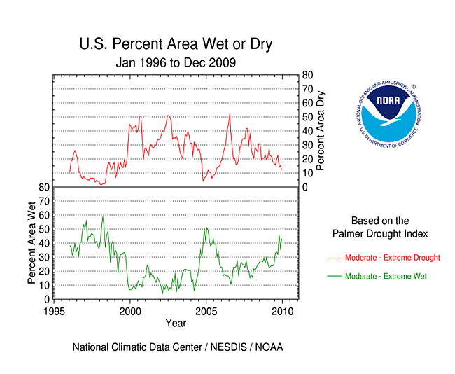
*This drought statistic is based on the Palmer Drought Index, a widely used measure of drought. The Palmer Drought Index uses numerical values derived from weather and climate data to classify moisture conditions throughout the contiguous United States and includes drought categories on a scale from mild to moderate, severe and extreme.
[top]
Regional Drought Overview
The drought epicenters during 2009 were southern Texas, the southern Appalachians, California, and Hawaii. Severe agricultural impacts were felt, especially in Texas. Low streams, reservoirs and stock ponds, and depleted soil moisture combined to ravage agricultural (pasture, range and crop) lands early in the growing season. Nationally, short to very short (i.e., dry to very dry) topsoil moisture conditions reached a peak area in early July, with dry soils persisting in some areas through September. The percent area of the nation with below-to-much-below normal streamflow peaked in February, but low streams occurred in various areas as the year progressed.


Parts of south central and southern Texas (map) have been drier than normal for most of the last two years. Beneficial rains since September brought drought relief, but not before these areas turned in their driest September-August on record (climate divisions seven and nine).
Parts of the Southeast began 2009 with lingering moderate to extreme drought, with drought peaking in southern Florida in April. But by the beginning of summer, drought in the Southeast was mostly gone. Below normal precipitation during August-October brought areas of moderate to severe drought back to parts of the Carolinas.
Parts of the West, especially California, have suffered through three years of drought. Northern California began the year with moderate to extreme drought. Conditions improved throughout the year, but the state ended 2009 with areas of moderate to severe drought remaining.
Parts of the Upper Mississippi Valley and adjacent western Great Lakes have been in some level of dryness or drought for most of the last seven years. Northwest Wisconsin (climate division 1) had the driest 12-month October-September period on record in 2009 (October 2008-September 2009).
Moderate to extreme drought afflicted parts of Hawaii throughout 2009. Below-normal precipitation departures for the year were widespread across the islands. The U.S. Drought Monitor (USDM) depicted abnormal dryness across parts of Alaska during most of the year, with a small area of moderate drought along the southern coast during the summer months. Annual precipitation departures were below normal at many southern Alaska and central Alaska stations, with the USDM abnormally dry depiction expanding into central Alaska by year end. While drought was not depicted on the U.S. Drought Monitor map for Puerto Rico during 2009, annual precipitation was below normal for the southeastern third of the island.
[top]
Pre-Instrumental Perspective
Tree ring records provide a useful paleoclimatic index that extends our historical perspective of droughts centuries beyond the approximately 100-year instrumental record. Several paleoclimatic studies have shown that droughts as severe or worse, both in magnitude and duration, than the major 20th century droughts have occurred in the U.S. during the last thousand years. The following paleodrought report was prepared by the NOAA/NCDC Paleoclimatology and Climate Monitoring branches during 2009:
[top]
Contacts & Questions