|
Contents Of This Report: |

|
National Drought Overview
|
|
[top]
Detailed Drought Discussion
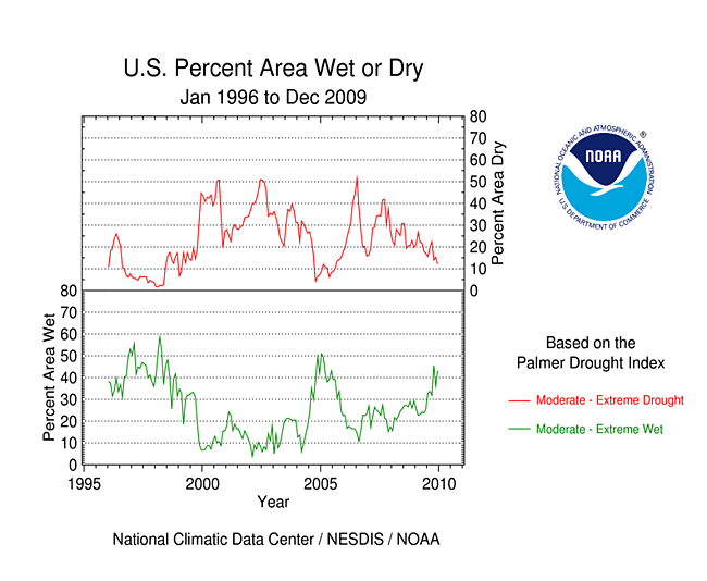
December 2009 was an exact opposite of November, with wetter- and cooler-than-normal conditions dominating much of the country. Drought all but disappeared from the eastern U.S. during December, and beneficial rains reduced the drought intensity in southern Texas. Drought and abnormally dry conditions continued in the Upper Mississippi River Valley, parts of Hawaii, and parts of the West, with the Pacific Northwest having a December rank of 14th driest out of 115. Abnormally dry conditions expanded across central Alaska. Unusually moist conditions prevailed from the northern Plains to the Southeast, and along the Mid-Atlantic coast to New England.

The U.S. Drought Monitor drought map valid December 29th, 2009.
December's 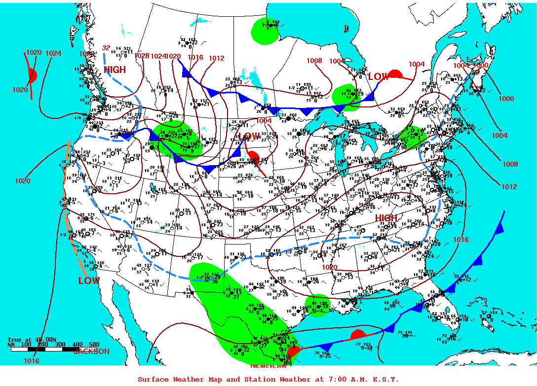 weather pattern was dominated by a series of low pressure systems and cold fronts which dumped heavy rain and widespread snow east of the Rockies. Large masses of Arctic air behind the lows dove deep into the United States. The excessively wet weather missed most of the drought areas of the West, however. While wintry weather dominated much of the contiguous U.S., warmer- and drier-than-normal weather dominated Alaska beneath an
  upper-level ridge of high pressure. This upper-level blocking ridge over Alaska and the eastern Pacific forced an upper-level cold trough downstream over Canada and the U.S., which was associated with the wet and cold weather over the Lower 48 States.
By the end of December, core drought areas in the U.S. included:
- parts of Hawaii and the Southwest, where moderate (D1) to extreme (D3) drought persisted; and
- the Far West, Upper Mississippi Valley, and southern Texas, which had areas of moderate (D1) to severe (D2) drought.
 |
 |
 |
Precipitation during the last one to three months benefited the drought areas of the Upper Mississippi Valley and south Texas, but long-term precipitation deficits were evident at the 9- to 24-month time scales. A near- to wetter-than-average December in the Southwest was a minor interruption to a long period of dryness which dominated for the last three to 24 months. These Standardized Precipitation Index (SPI) maps reveal dryness in the Northwest at the 1- to 3-month time scales and also longer-term (24-months). Dryness in the inter-mountain basin is evident at the 3- and 6-month time scales. A few pockets of dryness appear in the upper Ohio Valley at the 6- to 12-month time scales. The last one to two months have been drier than normal for parts of the southern Plains centered around Oklahoma, but impacts were minimal as this is the dry season for this area. The November-December map shows a swath of drier-than-normal weather from the Tennessee River Basin to the central Great Lakes. The SPI maps also clearly show the persistent wetness across the central and southeastern parts of the country.
 |
 |
 |
Did You Know?
Standardized Precipitation Index
Drought results from an imbalance between water supply and water demand. The Standardized Precipitation Index (SPI), one of several drought indices that have been developed over the decades, measures water supply, specifically precipitation. The SPI is computed over several time scales, typically from one month to 24 months, to evaluate both short-term drought and long-term drought. It can also measure precipitation excess. The U.S. Drought Monitor incorporates information from the SPI and many other drought indices, as well as drought impacts, in depicting drought.
The drought situation in Hawaii changed little during the month as drier-than-normal weather continued a trend that has lasted for the last three to 12 months. Many stations in central and southern Alaska were persistently drier than normal for December, the last three months, and the last 12 months. Most of the state was warmer than normal for December. Abnormally dry conditions (D0 on the USDM) expanded during the month into central Alaska where end-of-December snowpack and snow water equivalent percentages were low. December was drier than normal across north coastal Puerto Rico, and the last 90 days were drier than normal across the eastern half of the island. The year ended up drier than normal across parts of northeast to south central Puerto Rico. By the end of December, an area of abnormally dry D0 was added to the USDM map in the northeast corner of the island where precipitation deficits and streamflow levels were lowest.
On a statewide basis, Washington ranked eleventh driest for December precipitation, while Idaho had the fifth driest November-December and eighth driest September-December. Utah's July-December 2009 precipitation rank was 13th driest. But for Arizona, all time scales from August-December back through January-December ranked in the top ten driest category, including third driest for March-December and fourth driest for July-December, June-December, and the year (January-December).
Abnormal dryness and drought were evident in several indicators. A large part of the country, from the Southwest and western Texas to the northern Plains, had few days with significant precipitation. Part of the southern Plains around the Oklahoma panhandle had over three consecutive weeks with no significant precipitation. Soil moisture, as monitored by several models (NOAA Climate Prediction Center, NLDAS top soil layer and total soil layers, Leaky Bucket), was drier than average across parts of the West, northwestern Great Lakes, eastern Ohio Valley and Great Lakes, Florida, Hawaii, and Alaska. Well monitoring stations had sporadic reports of low groundwater in the Southwest, parts of the Great Plains, and even still in the East. Below-normal streamflow was measured across Hawaii and parts of the West and Texas, Wisconsin and adjoining Upper Michigan, and east central Florida. Satellite monitoring of vegetation health (Vegetation Drought Response Index, Vegetation Health Index) indicated stressed vegetation in the Southwest.

October through the following September is defined as the water year for the West. Water-year-to-date (October-December) precipitation has been near average over parts of the West but drier than average over other parts. The precipitation pattern was mixed, with the total precipitation percentages lowest in the intermountain basin and over Arizona. Snowpack water content percentages were lowest from the interior basins to northern Rockies, but above average over Arizona. The snow water equivalent at some high elevation remote stations in north central Utah to southwest Montana ranked in the driest fifth percentile. Winter and spring mountain snowpack provides a crucial water source for the summer melt season across much of the West. An analysis by the USDA indicated that reservoir levels were generally below average aross the Northwest to interior basins. By the end of December, data from the California Department of Water Resources indicated that levels in some California reservoirs were still below-average, especially in the north. According to the USDM, 28 percent of the West was experiencing moderate to extreme drought at the end of December, while the Palmer Drought Index statistic was 39 percent.
As summarized by the Southeast Regional Climate Center, December precipitation totals were above normal across the entire region, with exception to a small portion of northwest Alabama and several small sections of the Florida peninsula. The heavy precipitation contributed to a further reduction of drought and dryness across the region. A small area of abnormal dryness (D0) disappeared in the Carolinas during the first two weeks of the month along with a small region of moderate drought (D1) in central Florida. By the end of the month, only a very small area of south central Florida was classified as abnormally dry (D0).
As noted by the Southern Regional Climate Center, anomalously low precipitation totals for December were observed in northern Texas, western Oklahoma, northwestern Arkansas and in northeastern Texas. Anomalously high precipitation totals in the south of Texas helped alleviate drought conditions. At the start of the month, there were two significant areas of extreme drought. By the middle of the month, heavy precipitation totals allowed for a one to two category improvement. This improvement marked the first time since February 12, 2008, that there was no extreme drought in the state of Texas. Small areas of severe and moderate drought still prevailed in the southern part of the state. All other states in the Southern Region remained drought free. The National Weather Service reported a record low level for Lake Meredith, which is a major supplier of drinking water to the Texas panhandle.
As explained by the Midwest Regional Climate Center, long-term drought continued in northwest Wisconsin, extending slightly into Minnesota and upper Michigan. Long-term precipitation deficits were not yet overcome and lake levels remained low in the area.
[top]
State/Regional/National Moisture Status
A detailed review of drought and moisture conditions is available for all contiguous U.S. states, the nine standard regions, and the nation (contiguous U.S.):
| northeast u. s. | east north central u. s. | central u. s. |
| southeast u. s. | west north central u. s. | south u. s. |
| southwest u. s. | northwest u. s. | west u. s. |
| Contiguous United States |
[top]
Drought Indicators
- Palmer Drought Indices
- Standardized Precipitation Index
- long-term (36 to 60 month) percent of normal precipitation maps
- airport station percent of normal precipitation maps
- statewide precipitation rank maps
- Cooperative station percent of normal precipitation maps
- percent of average maps for the SNOTEL stations in the western mountains provided by the Western Regional Climate Center
- hydrologic year precipitation
- snow water equivalent of snowpack
- satellite-based observations of vegetative health
- National Weather Service model calculations of soil moisture, runoff, and evaporation
- National Weather Service model calculations of soil moisture using the Leaky Bucket Model
- Midwest Regional Climate Center model calculations of soil moisture
- topsoil moisture conditions observed by the USDA and mapped by the Climate Prediction Center
- pasture and range land conditions observed by the USDA and mapped by the Climate Prediction Center
- streamflow maps maintained by the USGS
[top]
Contacts & Questions