| Contents Of This Report: |
 |

|

|
|
|
The
 weather pattern
during October was variable, with periodic
storms affecting the entire U.S., and without major tropical
influence. As a result, drought conditions improved in some areas
of the West and High Plains (October 28
USDM versus September 30
USDM). But drought conditions deteriorated in parts of the
Southeast that missed the rains, and across parts of the Far West
and Hawaii. weather pattern
during October was variable, with periodic
storms affecting the entire U.S., and without major tropical
influence. As a result, drought conditions improved in some areas
of the West and High Plains (October 28
USDM versus September 30
USDM). But drought conditions deteriorated in parts of the
Southeast that missed the rains, and across parts of the Far West
and Hawaii. October was generally dry from the southern and middle Atlantic Coast States, across parts of the Ohio Valley, central Appalachians, southern Plains, Great Lakes, and across much of the West. Dry weather remained throughout central Alaska during October and the northwestern regions for the last 3 months. Drought conditions continued to deteriorate in Hawaii as drier-than-normal weather continued (October, last 3 months).  Dry weather continued across portions of Georgia and South Carolina this month, and extended into the Kentucky and the lower Ohio Valleys. Statewide precipitation totals trended toward average and the Southeast as a whole ranked 57th wettest. Streamflow, groundwater, and soil moisture levels (both observed and modeled - CPC, LDAS root zone, LDAS total column) continued low, with pasture and rangeland conditions worsening (observed and anomalous conditions). According to USDM statistics, about 30% of the Southeast was in moderate to exceptional drought by the end of the month.  |
 October saw some relief come to Minnesota, Wisconsin, and Michigan with all receiving precipitation near or above the 114 year average. Lingering drought impacts are still being felt through Wisconsin and the upper peninsula of Michigan as reflected in soil moisture, streamflow, and vegetative response. According to USDM statistics, about 20% of the Great Lakes-Midwest was in moderate to severe drought by the end of the month, a decline of three percent from September. Drought conditions persisted at both ends of the Great Plains. Parts of western North Dakota and adjacent Montana, and parts of southern Texas were still suffering from prolonged moisture shortages, despite above normal rainfall through the central and northern areas of these states. October in Nebraska was the wettest on record and North Dakota experienced their 11th wettest October. Lingering moisture deficits could be seen in soil moisture, streamflow, and vegetative response. According to USDM statistics, about 16% of the South and 8% of the northern High Plains were in moderate to extreme drought by the end of the month.   A more detailed drought discussion, provided by the NOAA Regional Climate Centers and others, can be found below. |
|
|
|
According to the Southeast Regional Climate Center, monthly precipitation totals were below normal across Virginia, North Carolina, extreme northern South Carolina, northeast Georgia, and Puerto Rico with many locations reporting less than half of the normal precipitation. In contrast, large portions of Georgia and South Carolina as well as eastern Alabama displayed above normal precipitation with many locations recording totals exceeding 150 percent of normal. Much of this rain was associated with the movement of two cyclonic systems across the region on the 9th to 11th and the 24th to 25th of the month. The second system produced exceptional totals in coastal Georgia and South Carolina with Charleston, South Carolina recording 6.57 inches (167mm) of rain. This rainfall contributed substantially to the monthly totals of 11.10 and 9.29 inches (282 and 236mm) at Charleston, South Carolina and Savannah, respectively, which rank as the 2nd and 4th wettest Octobers on record. Florida displayed much variability in monthly precipitation totals with Key West reporting over 12 inches (305mm) and Mayport, immediately east of Jacksonville, reporting only 0.55 inches (14mm). Strong northwesterly flow produced orographic snowfall across higher elevations of the southern Appalachians during the late month cold air outbreak. Mount Mitchell, North Carolina and Burkes Garden, Virginia reported 4 and 2 inches (50 and 25mm) of snow, respectively, between the 27th and 29th of the month. Lake Hartwell on the South Carolina / Georgia border set a new record for extreme minimum pool elevation today, October 21, 2008 when it dropped to 642.385 feet - 18 feet below normal pool level of 660 feet! This beat the previous record minimum set on 12/24/1981 when the minimum was 642.40 feet. There was little change in the drought lingering across portions of the region during the month. Exceptional drought continued to plague northwestern South Carolina, while extreme drought conditions continued to affect western North Carolina and northern Georgia. Moderate drought conditions affected areas farther south including central Georgia and extreme northeastern Alabama as well as northeastern North Carolina. As noted by the Southern Regional Climate Center, with the exception of the Texas and Oklahoma panhandles, precipitation for the month of October was generally below the expected monthly values. In the northwestern corner of the Southern region, precipitation totals varied from 150-400 percent of normal. In Oklahoma, there was a sharp precipitation gradient, with monthly totals decreasing rapidly over the central portions of the state. In eastern Oklahoma, precipitation totals were as low as 5-25 percent of normal, but generally between 25 and 50 percent of normal. Similar anomalies were also observed in southern Louisiana, southern Mississippi, and in particular, south east Texas where serious drought conditions have persisted from the previous month. Northern Mississippi and western Tennessee recorded near normal precipitation values for the month as did the south central counties of Arkansas. Drought conditions in the Southern Region changed little from last month. Extreme drought conditions are still being observed in central Texas, and in eastern Tennessee. Central Tennessee is currently in a state of severe drought, as is a small area in south central Texas. Abnormally dry conditions are currently being observed in southern Louisiana, where precipitation has been quite scarce since the tropical cyclone activity associated with Hurricanes Gustav and Ike. Finally, some moderate drought is also present in eastern Oklahoma. As explained by the Midwest Regional Climate Center, October 2008 precipitation was near to above average across most of the western half of the Midwest, while eastern portions of the region saw only 50 percent to 75 percent of normal precipitation. Rainfall was heaviest this month in extreme western parts of Iowa and Minnesota, where as much as 300 percent of normal rainfall was reported. Some areas of the Midwest also saw their first snowfall of the winter season this month. Parts of northern and northwestern Minnesota, and northern Wisconsin received up to an inch of snow, with isolated totals of more than two inches across upper Michigan. As noted by the High Plains Regional Climate Center, for October 2008 the region was wet, receiving ample precipitation, with the exceptions being portions of Wyoming and Colorado. Parts of Kansas, Nebraska, and even Colorado received 500 to 750 percent of normal precipitation with Minden and Kearney, NE having their wettest October ever. This precipitation was welcome as it helped alleviate drought conditions in a number of locations. According to the Drought Monitor, drought conditions have improved in South Dakota, western North Dakota, and across the Colorado-Kansas border. California: The California Department of Water Resources (www.water.ca.gov/drought) called the drought of the past two years, "the most significant water crisis in California's history." The drought was also arguably the biggest factor in the wildfires that made this year's "the worst fire season in California's history," according to Governor Schwarzenegger and CalFire. California said Thursday that it plans to cut water deliveries to their second-lowest level ever next year, raising the prospect of rationing for cities and less planting by farmers. The Department of Water Resources projects that it will deliver just 15 percent of the amount that local water agencies throughout California request every year. The amount of water being stored in California reservoirs is at its lowest point in 14 years, underscoring the severity of a worsening drought that could prompt providers to order rationing in San Diego and Riverside counties as early as January. According to media reports, the California Department of Water Resources estimated that, so far this year, the agricultural industry has lost $260 million statewide as almost 80,000 acres were left unplanted or abandoned. The hardest hit sectors were rangeland for cattle and cotton, which lost $95 million and $62 million, respectively. Farmers in the Central Valley say they'll be forced to fallow fields, while cities from the San Francisco Bay area to San Diego might have to require residents to ration water. As noted by the Northeast Regional Climate Center, overall, the Northeast averaged 3.18 inches (8.08 cm) of rain, or 91 percent of normal in October 2008, but totals were quite variable. West Virginia and Maryland were the driest states, with only 44 percent and 47 percent of the normal October rainfall, respectively. New York, at 128 percent of normal and Vermont, with 137 percent of normal, were the wettest states. Drought conditions worsened in southern West Virginia, according to the U. S. Drought Monitor issued at the end of October. Moderate drought conditions expanded farther north, to the middle of the state, while the southern tip of the state was in the severe drought category. The northern part of West Virginia and far western Pennsylvania were abnormally dry, as was much of Delaware, parts of eastern Maryland and southern New Jersey. Dry conditions in South Jersey resulted in a fire that burned over 2,000 acres within the Wharton State forest from the 21st to the 25th. |
|
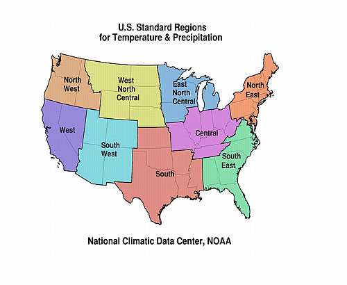
| A detailed review of
drought and moisture conditions is available for all contiguous U.S.
states, the nine standard regions, and
the nation (contiguous U.S.): STATES: REGIONS:
|
|