U.S. Drought Summary:

The data presented in this drought report are preliminary. Ranks, anomalies, and percent areas may change as more complete data are received and processed.
National Drought Overview
Dry conditions occurred during much of the year across large parts of the Southeast, West, northwestern Great Lakes, and south central Texas. Most months (February-December) had severe dryness over one or more of these areas. The year was dominated by weather patterns which brought large areas of wetness to the central and northeastern areas of the country, especially from February through October and December, with other areas missing the precipitation. The December 30 U.S. Drought Monitor map depicts conditions at the end of 2008.
Several short-lived dry episodes occurred in other regions throughout the year, notably along the mid-Atlantic coast states in January and August (Delaware had its driest August on record), the Gulf Coast states in March and July, the eastern Great Lakes in April, New England and Florida in May, the Ohio Valley in August and September, and parts of the northern Plains in March, April, July, and August. The percent area* of the contiguous U.S. experiencing moderate to extreme drought expanded and contracted several times during the year, starting at about 27 percent at the beginning of January, reaching a peak of about 31 percent in June, and declining to about 21 percent by the end of December. According to U.S. Drought Monitor statistics, the percent of the U.S. (including Alaska, Hawaii, and Puerto Rico) experiencing moderate (D1) to exceptional (D4) drought was about 29 percent at the beginning of the year, peaked at 30 percent in mid-January, then generally declined throughout the year to about 16 percent by December 30 (after a slight surge during the summer).


*This drought statistic is based on the Palmer Drought Index, a widely used measure of drought. The Palmer Drought Index uses numerical values derived from weather and climate data to classify moisture conditions throughout the contiguous United States and includes drought categories on a scale from mild to moderate, severe and extreme.
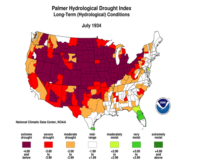
The most extensive national drought coverage during the past 110 years (the period of widespread reliable instrumental records) occurred in July 1934 when 80 percent of the contiguous U.S. was in moderate to extreme drought. Although the current drought and others of the 20th century have been widespread and of lengthy duration, tree ring records indicate that the severity of these droughts was likely surpassed by other droughts including that of the 1570s and 1580s over much of the western U.S. and northern Mexico.
Regional Drought Overview
The very dry conditions of 2007 continued into 2008 in some areas. Similar to last year, impacts from drought in 2008 were felt largely by the agricultural and hydrological communities. Low streams, reservoirs and stock ponds, and depleted soil moisture ravaged pastures, range land, and cropland as the growing season progressed. Nationally, short to very short (i.e., dry to very dry) topsoil moisture conditions reached a peak area at the end of July, with August showing recovery in some areas but worsening conditions in others. As the year progressed, the percent area of the nation with below to much below normal streamflows generally decreased, but increased again later in the year.


Conditions in the Southeast U.S. were especially dry. The year started with low streamflows across much of the region. Voluntary and mandatory water restrictions continued in many communities. April 2007-March 2008 was the driest April-March on record for North Carolina, prompting then-Governor Easley to ask local officials to continue their aggressive water conservation efforts. Beneficial April rains improved conditions slightly, but dry weather returned in the summer.


USGS streamflow for July 2008. Brown shades are below-average streamflow, blue shades are above-average streamflow.


By the end of June, more than half of the topsoil in several southeastern states was in dry to very dry condition, and pasture and range land was in poor to very poor condition across one-third of North Carolina, 44 percent of Georgia, and two-thirds of South Carolina. Upstate South Carolina (climate division 2) experienced the driest August-July in its 115-year record. While its duration was not a record, the intensity of the 2008 drought reached record low levels for Upstate South Carolina, according to the Palmer Drought Index. By October, river levels and well levels in the North Carolina-South Carolina-Georgia border area were at all-time record low levels or approaching these levels. On October 21, Lake Hartwell set a new record for extreme minimum pool elevation when it dropped to 642.385 feet, 18 feet below normal pool level of 660 feet. The lake is located in northeast Georgia along the Georgia-South Carolina border and is one of the Southeast's largest and most popular public recreation lakes. Built by the U.S. Army Corps of Engineers between 1955 and 1963 as part of a flood control, hydropower, and navigation project, authorized purposes now include recreation, water quality, water supply, and fish and wildlife management. According to media reports (AP 10/19), communities in the Southeast continued to struggle in the face of the lingering drought:
- Some communities faced water restrictions.
- Burning bans and warnings were common in the Virginias.
- Tennessee Governor Phil Bredesen requested a federal designation of agricultural disaster for 39 counties because of crop and livestock losses.


Persistent dryness spread into the Ohio Valley and Great Lakes by August. Topsoil was dry to very dry across 70 to 80 percent of Kentucky, Indiana, Ohio, Michigan, and Wisconsin, with half of the pastures and range land of Kentucky and Michigan, and nearly half in Ohio, in poor to very poor condition. By the end of September, the percentages had reached 93 percent (for topsoil) and 77 percent (for pastures and range land) in Kentucky, which had the second driest August-September on record.
Three main areas of the Great Plains suffered from drought in 2008: the northern Plains, south central Texas, and the area where the Oklahoma panhandle touches Colorado, New Mexico, and Texas.

The cold half-year (October-March) is the dry season in the northern Plains. Nevertheless, the 2007-2008 winter was much drier than normal for much of the area, with North Dakota experiencing the driest December-March and November-March in its 114-year record. Minnesota had the second driest November-March. The dryness continued into the spring, although not as severe, with North Dakota experiencing its 13th driest March-May. By the end of May, 55 percent of the state had topsoil in the dry to very dry categories and 52 percent of the pasture and range land was in poor or very poor condition. Drought was most severe in the western part of the state. Pasture and range land remained ravaged even as late as the beginning of fall.

The precipitation gradient was very sharp across the Oklahoma panhandle, with some precipitation falling over the eastern sections but mostly missing the western portions during the first six months of 2008. The Colorado State Climatologist's office reported a significant number of dust storms during the spring in southeast Colorado. By June, drought was having some severe localized impacts in the Oklahoma panhandle. According to media reports (The Oklahoman, 6/13), impacts included large-scale livestock sell-offs, wildfires, and growing risk of significant dust storms. In Cimarron County, Oklahoma, the wheat crop was nonexistent this year, pastures were dormant or dead, and wind erosion of the soil was occurring -- according to old-timers in the area -- like back in the Dust Bowl days. Governor Henry requested federal disaster aid in June for Oklahoma farmers and ranchers who were hit by drought and extreme weather conditions in nine northwest counties. Exceptional drought conditions developed in the area by the end of the month, according to the July 1 U.S. Drought Monitor map. Beneficial rains over the area beginning in July improved conditions during the summer.

Conditions were dry in the southern Plains states at the beginning of 2008. According to the USDA, end-of-January state reports indicated that the winter wheat crop was suffering, with 61 percent of the crop in poor to very poor condition in Texas, 30 percent in Oklahoma, and 25 percent in Kansas. NOAA observations noted that, at the beginning of February, Lake Meredith in the Texas Panhandle reached a record low level at 50.15 feet. At 48 feet, portable pumps must be brought in to get water from the lake as the lake level will be below the permanent pumps. Lake Meredith is a major supplier of water to the Texas Panhandle. By March 30, 47 percent of the winter wheat crop in Texas, 32 percent in Colorado, 21 percent in Oklahoma, and 20 percent in Kansas was rated poor to very poor. By the end of June, over 70 percent of the topsoil in Texas and New Mexico was rated dry to very dry. The January-June 2008 precipitation pattern showed the driest areas over south central and western Texas.
Southern Texas (climate division 9) experienced the driest October-June in its 114-year record. According to media reports, Texas agricultural specialists feared record losses in agriculture during 2008 due to heat and drought conditions combined with skyrocketing input costs. Cotton producers in southern Texas had already lost nearly their entire crop. By the end of October, 57 percent of the topsoil moisture in Texas was still short to very short. As reported by local media, the flow at Jacob's Well, a natural spring in Hays County in central Texas, stopped in September for only the second time in its recorded history. The Wimberley Valley Watershed Association's David Baker said, "In the summer of 2000 it did stop for the first time that we know of in modern times ... and in all accounts that we know of. It did flow through the drought of the 50's." The well is fed by the Trinity Aquifer, which is the primary water supply for Wimberley and much of the Hill Country. Very dry conditions during November and December ended the year, with Texas having the fourth driest December statewide. By mid-December, many streams and rivers in central Texas were below 10 percent of normal flow, causing reservoir levels to continue to fall. Precipitation in San Antonio during the 15-month period through November (September 2007-November 2008) was the lowest in any similar period since recordkeeping began in 1871. USDA crop reports at the end of the year revealed poor to very poor conditions for 74 percent of Texas oats and 46 percent of wheat. Yields were generally low (with a few areas of good yields) for the Texas cotton, sorghum, and pecan harvests.


In the three climatological regions of the western U.S. -- the West, Northwest, and Southwest regions -- the 2007-2008 winter began with above-normal precipitation, which laid down an above-normal mountain snowpack. There was hope that the spring snowmelt would fill reservoirs which were largely below normal, but the precipitation pattern shifted in March with drier weather predominating for the next several months. This resulted in a drier-than-normal hydrological year (October-September) for many western states, in spite of the wet start to the winter. Beneficial rain and snow fell over parts of the West during November and December. But, by the end of 2008, reservoirs were still below normal for several western states.
For California, October 2007-September 2008 was the second consecutive dry hydrological year. The persistent dryness in 2007 had depleted soil moisture, ravaged pastures, and dried up streams, wells, and springs. Voluntary and mandatory water restrictions were in place in many communities in California at the beginning of 2008. As the pattern starting in March 2008 exacerbated conditions, the dryness was so severe that Governor Schwarzenegger declared the first statewide drought since 1991. Numerous lightning-sparked wildfires were burning across the state by the end of June, with 97 percent of the state's pasture and range land in poor to very poor condition. By the beginning of September, this value had reached 100 percent for California and 52 percent for Oregon. Irrigated crops were thriving, but dryland agriculture was suffering.


By late summer and early autumn, soils in the Pacific Northwest states continued to dry, with topsoil moisture reaching more than 50 percent short to very short for Idaho, Oregon, and Washington. Natural vegetation was significantly stressed across much of the West. Soil moisture conditions remained dry in some areas at the end of December.
March-October 2008 was the driest such 8-month period on record for California and Nevada. California also had the driest February-September, February-November, and March-June on record. As October came to a close, the California Department of Water Resources (www.water.ca.gov/drought) called the drought of the past two years, "the most significant water crisis in California's history." The drought was also arguably the biggest factor in the wildfires that made this year's "the worst fire season in California's history," according to Governor Schwarzenegger and CalFire. Water supply problems in the months ahead were expected. As noted by the North County Times (10/20), the amount of water being stored in California reservoirs was at its lowest point in 14 years, underscoring the severity of a worsening drought that could prompt providers to order rationing in San Diego and Riverside counties as early as January 2009. According to news reports (San Francisco Chronicle, 10/30), California announced that it planned to cut water deliveries to their second-lowest level ever in 2009, raising the prospect of rationing for cities and less planting by farmers. The Department of Water Resources projected that it would deliver just 15 percent of the amount that local water agencies throughout California request every year. The reservoirs that are most crucial to the state's water delivery system were at their lowest levels since 1977, after two years of dry weather and court-ordered restrictions on water pumping out of the Sacramento-San Joaquin Delta.


Persistently dry weather during much of 2008 in Hawaii resulted in severely reduced streamflows by spring. Continued dryness resulted in poor pasture, range land, and irrigation reservoir conditions, prompting the introduction of extreme drought to the islands during the summer. Through July 22, year-to-date rainfall totals stood at just 2.86 inches (30 percent of normal) in Honolulu, Oahu; 2.98 inches (26 percent) in Kahului, Maui; and 8.22 inches (40 percent) in Lihue, Kauai. On the Big Island, Hilo's January 1-July 22 rainfall totaled 74.66 inches (109 percent of normal), although more than half (39.08 inches) of that amount fell during the first half of February. According to agricultural reports from the USDA, drought on parts of the Big Island dried up stock water ponds normally supplied by runoff. On Oahu, a mandatory 30 percent reduction in water use was issued for the Waimanalo irrigation system users. Sugar planting was suspended in July on central Maui. On the island of Oahu, deteriorating conditions led to additional requests for voluntary reductions in public water consumption. Widespread beneficial rains fell in December, but significant drought continued over Moloka'i, Maui, and the Big Island at the end of the year.
Pre-instrumental Drought Perspective
Tree ring records provide a useful paleoclimatic index that extends our historical perspective of droughts centuries beyond the approximately 100-year instrumental record. Several paleoclimatic studies have shown that droughts as severe or worse, both in magnitude and duration, than the major 20th century droughts have occurred in the U.S. during the last thousand years. The following paleodrought report was prepared by the NOAA/NCDC Paleoclimatology and Climate Monitoring branches during 2008: